All Activity
- Past hour
-

First Winter Storm to kickoff 2025-26 Winter season
MarkO replied to Baroclinic Zone's topic in New England
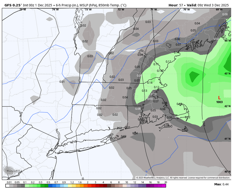
495 does seem to be the cutoff for many storms. Growing up a mile from the ocean in Peabody, we were often on the wet side of storms, but I couldn't tell you how many storms were mainly white in Lowell (including the 2008 ice storm) where it was just rain only a few miles SE of here. Once again, it seems like 495 will be where the R/S line is. I think Ray will do much better in Methuen than his old place in Wilmington. -

First Winter Storm to kickoff 2025-26 Winter season
powderfreak replied to Baroclinic Zone's topic in New England
Just rots over 495.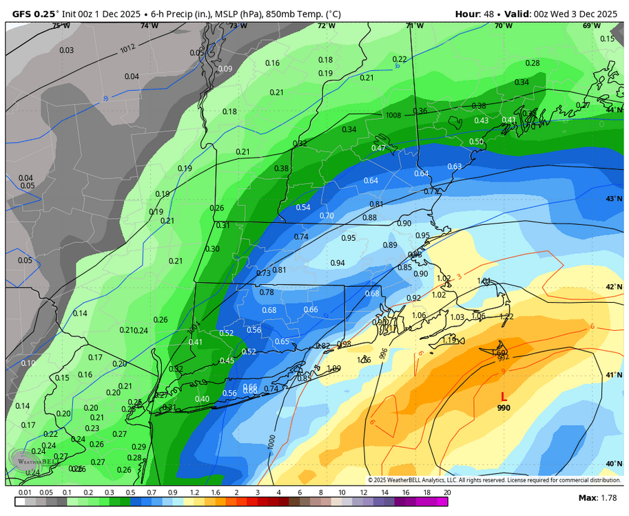
-

First Winter Storm to kickoff 2025-26 Winter season
radarman replied to Baroclinic Zone's topic in New England
NOP usually means rain in the lowlands up to Rt 2 -
models, model, models! so many models! eons ago there were two models that were the go to models. I think it was the AVN and the Eta model. I remember folks talking about the E/A rule (i believe it was called). If these two models agreed on snow, then it was a sure bet. Later the models changed and increased in number, but when the Euro came to America, it rapidly took over the kingship of models to trust most. Now with so many models printing out such a variety of possibilities when it comes to snow in a given area, I've had to put all my chips into the Ji rule: whichever model shows the least amount of snow is the one that verifies. I find if I put my faith in the snowless model, it usually verifies, and if not, I get the excitement of a surprise snow! According to the Ji rule, I should expect no snow for the next two storms, despite the fact that some of the majors are showing some snow for my area just north of Baltimore. Going with the least snow solution is depressing, but there is the thrill of a surprise, if indeed, the least snowy model is wrong and we get a decent snow. Hate to say it, but Ji is becoming my HM! He will never, ever take the place of usetobe, however. usetobe is always the EF Hutton of this board. When he says its gonna snow, it snows! All that said, my faith in the flakes/forecasts really rests in the many mets. who post on this board. Their insight, thoughts and ways of understanding the synoptics and interpret the models is really of extreme value. What a blessing it is to be able to learn from so many trained mets., forecasters, and expert teachers! And if I am too old to learn it, I just appreciate the knowledge shared by our experts!! Keep on doing what you do so well!!! There will always be onlookers (like me) who will gain from your insight.
-

First Winter Storm to kickoff 2025-26 Winter season
ORH_wxman replied to Baroclinic Zone's topic in New England
GFS looks just a smidge colder near here than 18z but at this point it’s noise unless it does it again another couple of cycles. -
Noob vs Pro progression right there guys lol
-
First Winter Storm to kickoff 2025-26 Winter season
ORH_wxman replied to Baroclinic Zone's topic in New England
This area is pretty often on the correct side of the “495 gradient” despite being a little inside 495. But so many times I’ve seen huge gradients like 2 towns east. But you do get these events sometimes where it’s really more like ORH is the line…the lower part of the city even might be on the warm side of the gradient. This happened during the ice storm in 2008. Also during the March 2023 Firehose event. Lower elevations literally had 5” of slop and it was like 15” on winter hill and then 2 feet another 5 miles NW. granted, that was the most extreme I’ve seen. -

Central PA Fall Discussions and Obs
Blizzard of 93 replied to ChescoWx's topic in Upstate New York/Pennsylvania
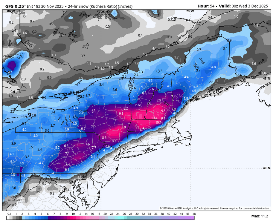
0z GFS holds serve & delivers Warning snow to most of us again for Tuesday.
-
Yes once that trough moves over Alaska in the 2nd week of December, I’d expect some milder air from the pacific to flood CONUS and lead to a moderation of temps and probably a pause in the storminess. Hopefully we can cash in before that happens
-
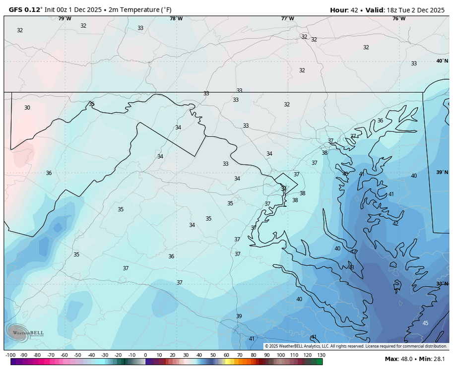
Temps stay at or below freezing until 1pm on latest GFS in my area. Icy Tuesday morning setting up.
-
We are around +1 for November. 1.5 inches of snow. The high was 29 on the 10th. Highest temp was 70. The warmest day was the 22nd, which was +18 due to its high low temperature. Today will probably end up around -8 to close the month. We were BN 16 days of the month and AN 14.
-
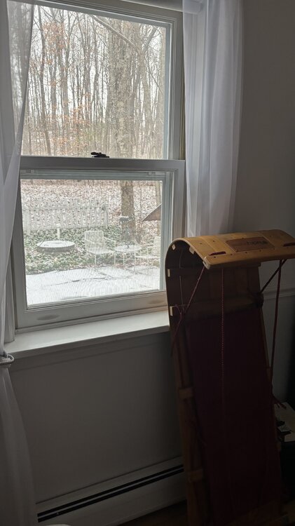
0.2” here in the valley today. It snowed on an off all day at 35°F until it flipped to drizzle and RN/SN mix for the last two hours leading up to cold front #1 at 9pm. Pretty day.
-
We are who we thought we were
-
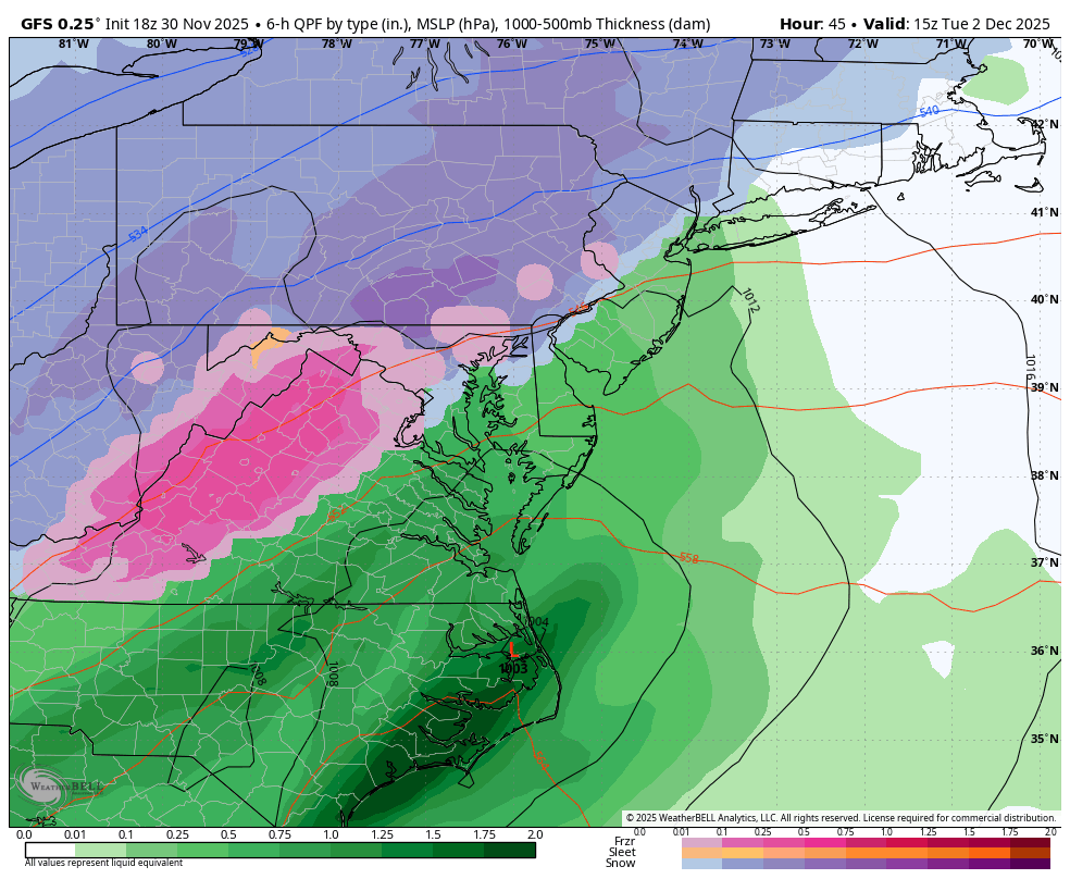
GFS keeps the northern crew happy
-
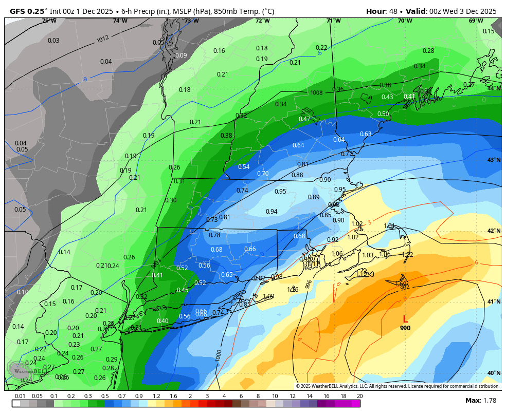
WB 0Z GFS also a little drier.


-
Here's my quick breakdown as a bit of practice for my upcoming atmosphere and weather test. I am going to start with the negatives before ending with the path to victory I can imagine. I think the more notable issue is that the high appears to go from helping to hurting before the event even starts. By Friday midday the main surface high pressure is off the coast which promotes flow in from the Atlantic (which as a reminder it is still early December). Additionally, we have no real mechanism for keeping any cold air in place for the layers below 700mb as the surface high is unhelpful. The upper level low and surface low are both in a position to eat away at the remaining cold wedge before precipitation even comes close to our area. Just take a look at this 925mb map. The flow is completely out of the south 12 hours before the event even begins. It should be noted our saving grace here is that the storm is weak so the winds are minimal. The better news is that the 850+ level is less affected by the surface high and general weak low that is "attacking" from the south. This means that the flow is firstly, not that strong; secondly, out of the southwest/westsouthwest. Once you get above 850mb the flow largely veers to be out of the west as there just isn't enough cyclogenesis to really distort the westerly flow. All of this said, I think that ultimately with currently modeling the event this Friday is not in a good spot. I believe this as in order to get a real plowable snowstorm we need two things to go right. 1. A stronger low pressure center in order to actually get lift into the area 2. A correspondingly stronger/more stubborn high. If we get 1. and not 2. all of the thermal issues I highlighted goes from bad to worse as the southern flow just becomes stronger. Meanwhile, if we get 2. but not 1. then we probably end up suppressing this storm. In the end it seems like another thread the needle event that just seems unlikely to get more than 1-3 inches. Disclaimer is that ofc I would be happy with 1-3 inches but this analysis is from a "how could we get a plowable storm" perspective. That said, I think there is room for hope as it is not impossible we get 1. and 2. to align. The 5h pattern isn't horrible after all. There is clearly a path here. Though as it stands everything is slightly off. We have a some semblance of a 50/50, though we need it to be further southwest if we want to trap the surface high pressure in. Additionally, the shortwave out west isn't in a horrible spot. However, as it stands it seemingly gets both weakened and pulled north by the larger low pressure center over central Canada. I think the path to victory here is quite simply that the low out west doesn't get stuck. Currently, the energy enters the southwest around hour 60 then languishes there through 110 before a secondary shot of energy pulls it along. I think if we're able to have the first ball of energy keep its form and progress eastwards and the second shot of energy enters faster its honestly quite possible we manage to get a stronger, more consolidated, and further south system without as much northern stream interference. Additionally, the 50/50 would naturally be in a better spot which would help offset the WAA from a stronger storm. Thank you for listening to my Ted-Talk and if any met read this through let me know if I am gonna fail my test. TDLR: As it stands I don't think Friday looks good for anything more than 1-3 inches, however, I think the path to victory for a bigger storm is still there if the energy out west is more progressive
-
 meh, even here in rockland county I’m not overly excited. I’m expecting maybe an inch or so(If that).
 -
.thumb.png.4150b06c63a21f61052e47a612bf1818.png)
First Winter Storm to kickoff 2025-26 Winter season
HIPPYVALLEY replied to Baroclinic Zone's topic in New England
It's amazing how the two E to W highways (Pike and RT2) are often viable dividing lines wrt frozen precip in winter storms with marginal temp profiles. -

First Winter Storm to kickoff 2025-26 Winter season
TheSnowman replied to Baroclinic Zone's topic in New England
Ahhhhh from Totally Screwing RI to…. Totally Screwing RI? Ya. Same Picture to me. -
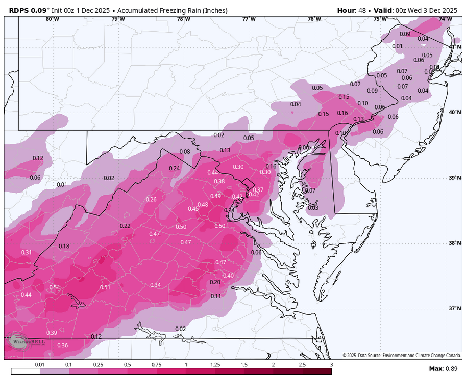
if taken verbatim, RDPS zr in the metros might be an issue with these temperatures

-
My Average was a couple degrees colder than KTRI. The high on the 10th here was 33. Some area's remained below freezing that Day. The Month was near Normal. I wonder how John's Location faired.?.
-
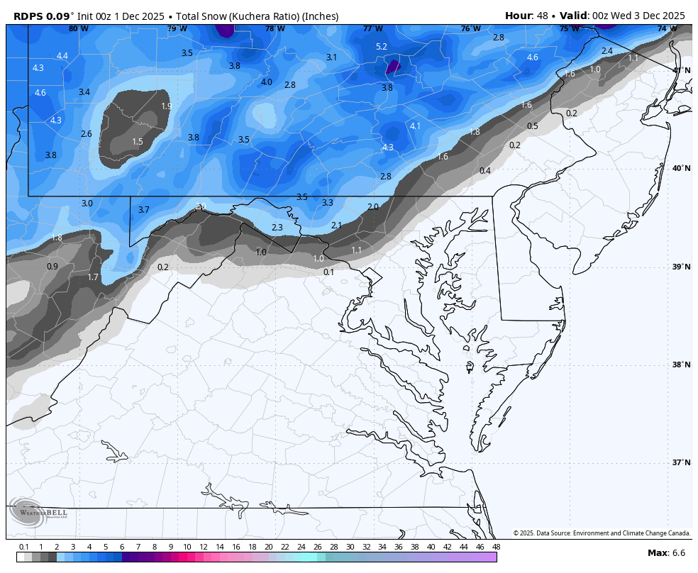
WB 0Z RDPS (less precip.)


-
First Winter Storm to kickoff 2025-26 Winter season
powderfreak replied to Baroclinic Zone's topic in New England
Elevation at that same latitude would certainly be favored. What a legendary snow spot Winter Hill is… decades of wins in winter events (proven on the forums) compared to surrounding areas. Hopefully it can go isothermal paste for your current spot. How many times is “the Pike” the boundary zone over the years? Could be another one. -
I mean this sounding from the Catoctins really says it all. Though, it appears if you're able to keep the column cool it will be dumping with a saturated atmosphere up to 500mb and good lift in the DGZ
-
First Winter Storm to kickoff 2025-26 Winter season
HIPPYVALLEY replied to Baroclinic Zone's topic in New England
Sane and realistic.