All Activity
- Past hour
-
I’ll try to stop bitching this wx has been nice lol I’m being a big baby right now

-
There's a strangeness about the local hemisphere ( along 30 N from west of California, east to the Sargasso Sea/N. Atl Basin ) where the ridges are perforated by all these pinch mid/u/a/ lows and/or TUTTs and such. That circumstance hugely limits the likeliness than any MDR TC would firstly be able to survive the increased shear quotient in the means. Also, another likeliness killer is that steering fields are not west-->east along extended distances because these punched holes in the ridge offer too many more opportunities that encourage capture into early retirements. (hint, I know why that overall circumstance is happening, but the CC explanation rubs those that swear by not denying while denying any evidence that connecs to CC ... CC is real so long as it doesn't interfere with the prospect of d-drip potency, huh )
-
Glad to hear it! Where did you go if I may ask?
-
The models are trending up with rain over the next couple weeks. Some runs are showing a series of slow-moving lows moving across the upper midwest.
-
If we finish this season below 100 ACE I for one will not be the least bit surprised
-

Central PA Summer 2025
Mount Joy Snowman replied to Voyager's topic in Upstate New York/Pennsylvania
Low of 60. Back from the beach. Kids had an awesome time and the weather was perfect. No rain in the bucket here. -
No rain in the forecast for at least the next 10 days. What will it take to break the cycle?
-
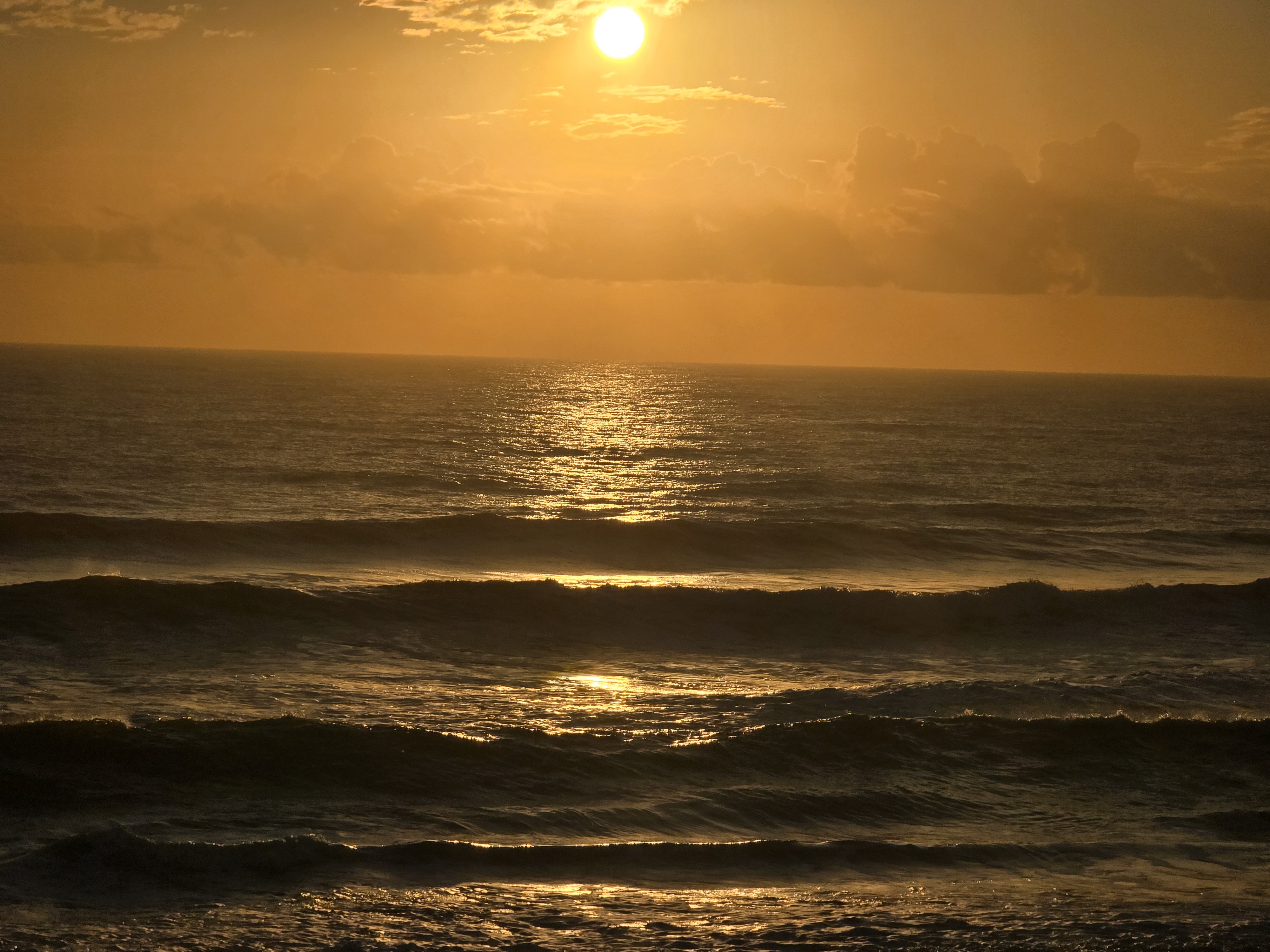
Oh man....I dearly miss that warm Florida surf. It's been too many years since I've been there.
- Today
-
The lower ACE this season than last year wasn’t that much of a surprise. All our 161+ ACE years since 2010 have seen a steep decline the following years. This year the record mid-latitude SSTs and cooling tropics are the main features creating the more stable conditions like we have been seeing more frequently in recent years. So the direction lower this season for ACE is flowing the recent pattern. But magnitudes will be unique to each season. The amount of the decline can vary from year to year. ACE step down pattern following 161+ seasons 2024….161….2025….39.3 so far 2020….180….2021…145…2022…94.4 2017….224….2018….132
-
Oh look! That's unusual! More rain and the lowlands are the bullseye. That's new lol. I hope this hot hand last into the winter.
-

2025-2026 ENSO
40/70 Benchmark replied to 40/70 Benchmark's topic in Weather Forecasting and Discussion
Mot of us have already been using this for a few seasons. -

September 2025 OBS-Discussion centered NYC subforum
bluewave replied to wdrag's topic in New York City Metro
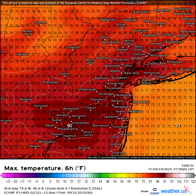
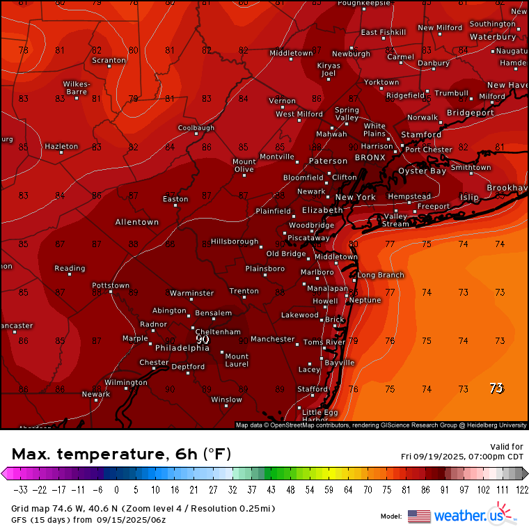
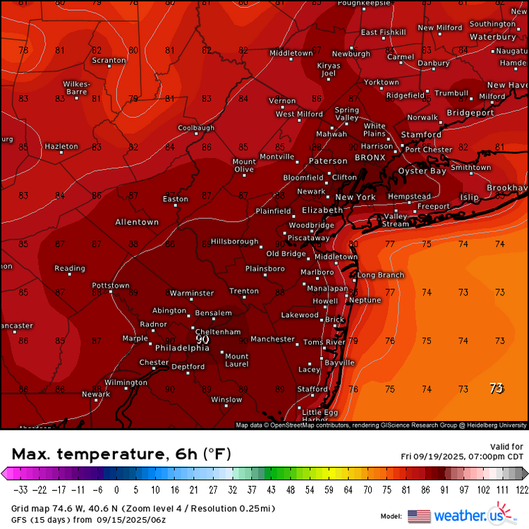
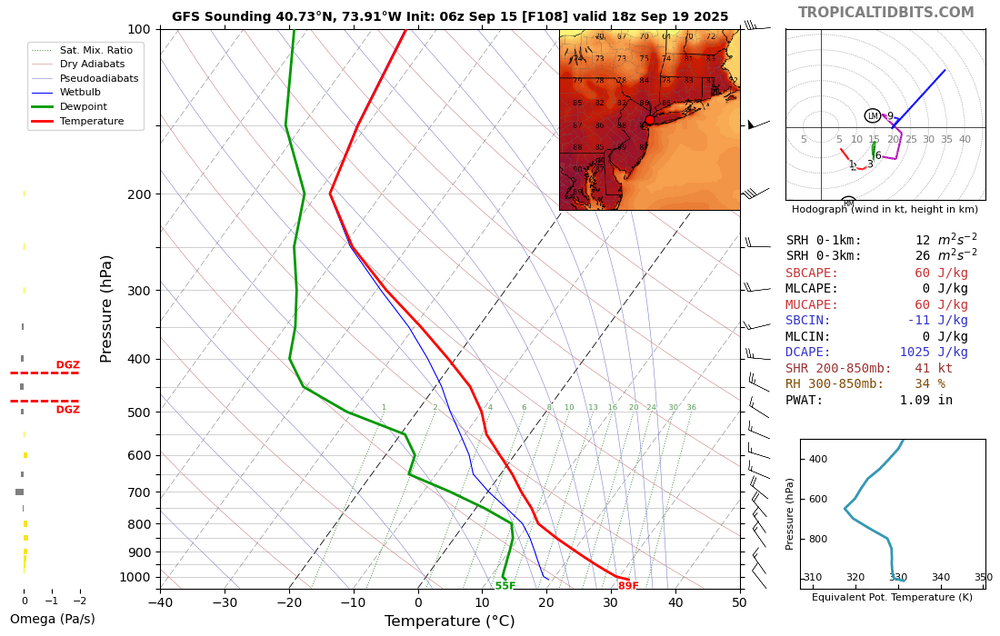
Friday looks like the warmest day of this week with Euro and GFS showing 85-90° potential on a dry W to NW downslope flow.
-
We have only seen 11 above normal temperature days in the last 44 days. Today should be one of those rare above normal temp days with highs well into the 70's to near 80 degrees. We turn cooler and possibly wetter by the middle of the week with our best chances of a little light rain coming on Tuesday night into Wednesday. We see a brief warm up by Friday before we turn quite a bit chillier once again by next weekend.
-
Brought the COC with me all the way to Florida. Record lows tonight. Surf is sweet water is so warm here.

-
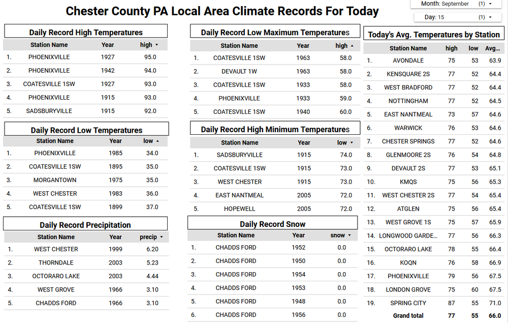
(002).thumb.png.6e3d9d46bca5fe41aab7a74871dd8af8.png)
E PA/NJ/DE Autumn 2025 Obs/Discussion
ChescoWx replied to PhiEaglesfan712's topic in Philadelphia Region
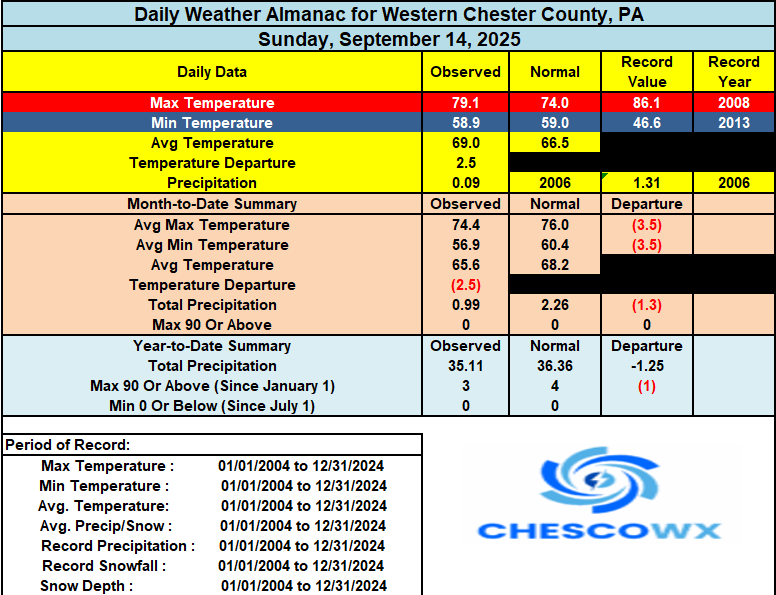
We have only seen 11 above normal temperature days in the last 44 days. Today should be one of those rare above normal temp days with highs well into the 70's to near 80 degrees. We turn cooler and possibly wetter by the middle of the week with our best chances of a little light rain coming on Tuesday night into Wednesday. We see a brief warm up by Friday before we turn quite a bit chillier once again by next weekend.
-
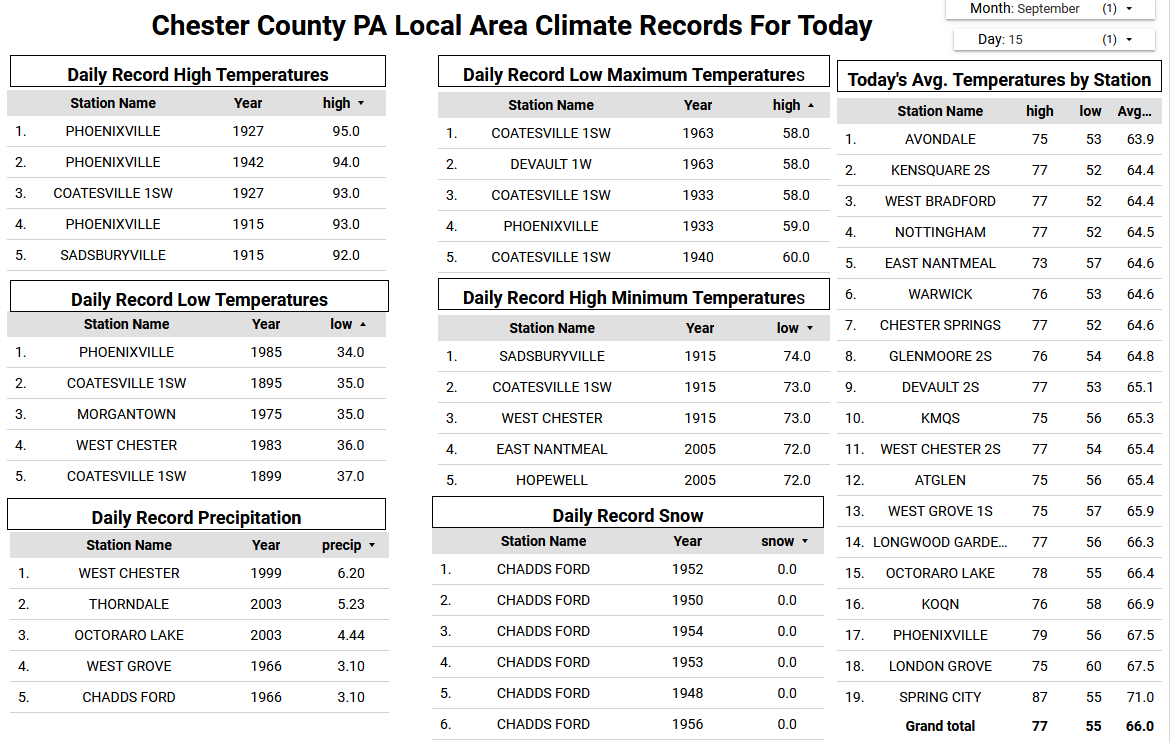
We have had .08 inches in the last 30 days with none in sight for the next 2 weeks on the models. Everyone's lawn is toast,and oak trees dropping leaves. People on the coast should get some with that low though. High 80's with some low 90's thrown in for my area for the next few weeks.
-
Torch !!
-

Pittsburgh PA Fall 2025 Thread
TimB replied to TheClimateChanger's topic in Upstate New York/Pennsylvania
Low of 61 at PIT appears to break the streak of sub-60 lows at 21 days. Earliest in the season that we’ve recorded three full weeks of sub-60 lows. -

September 2025 OBS-Discussion centered NYC subforum
jm1220 replied to wdrag's topic in New York City Metro
Yawn. But Sept is usually a yawn month here unless a hurricane is coming up. Amazing how this season is dead as a doorknob though. -

September 2025 OBS-Discussion centered NYC subforum
SnowDemon replied to wdrag's topic in New York City Metro
And the 6z this morning says what 90s? lol. -
September 2025 OBS-Discussion centered NYC subforum
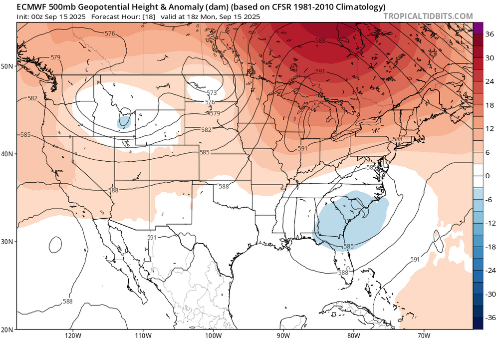
bluewave replied to wdrag's topic in New York City Metro
Record 500 mb ridge to our north will keep the heaviest rains to our south this week.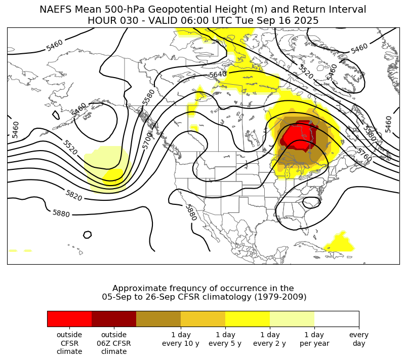
-
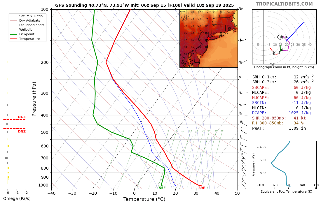
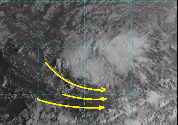
I'm not sure what the science is in this area of TC genesis ... or if there's any correlation at all, but this current high ranked invest out in the MDR has a very large initial mass field envelopment. I'm wondering if that presages a system that is also spatially larger than normal? It is evolving westerly return flow along the equatorial side, as evidence by cloud material/satellite, but these initial stages of that evolution extends to an unusually vast distance SW and S, some 500 km ...
-
Wow what a difference. 4 more days of 90s here on the other side of the state. Finally maybe some rain by Friday.
-
Soil moisture very low across the entire Northeast and Mid-Atlantic
-

September 2025 OBS-Discussion centered NYC subforum
Dark Star replied to wdrag's topic in New York City Metro
And on September first, PhiEaglesFan712 said fall had set in...