All Activity
- Past hour
-
Oh for sure…just some notable events THIS year have transpired that way. Recency bias of course. .
-
UHI, altitude, valley, surfaces, river; basically everything possible to minimize snow accumulation. DCA is particularly bad.
-
Wondering how tough it will be to measure from here. At my place I have a deck table that's good like for 1/25 but there's no way it would be tonight. AaaarrrRRRRRGH!
-

"Don’t do it" 2026 Blizzard obs, updates and pictures.
Torch Tiger replied to Ginx snewx's topic in New England
moved out in 1996 (missing Edouard hurricane) on cape cod and 1997 blizzard. sucked but there wasn't much beyond that until the 2000's -

Southern MD / Lower Eastern Shore weather discussion
Prestige Worldwide replied to PrinceFrederickWx's topic in Mid Atlantic
Wow- up to 42000 now? Wind is really ripping -

"Don’t do it" 2026 Blizzard obs, updates and pictures.
40/70 Benchmark replied to Ginx snewx's topic in New England
This what I meany by my sports analogy earlier.....the modeling build up being the regular season, but all that matters is how it actually plays out in the actual dance. This is why I sometimes get leery of being under the pixel orgy beforehand....it's like ...well, going to the Super Bowl 18-0. -

"Don’t do it" 2026 Blizzard obs, updates and pictures.
TalcottWx replied to Ginx snewx's topic in New England
Shocking for some, I know. -
.thumb.png.4150b06c63a21f61052e47a612bf1818.png)
"Don’t do it" 2026 Blizzard obs, updates and pictures.
HIPPYVALLEY replied to Ginx snewx's topic in New England
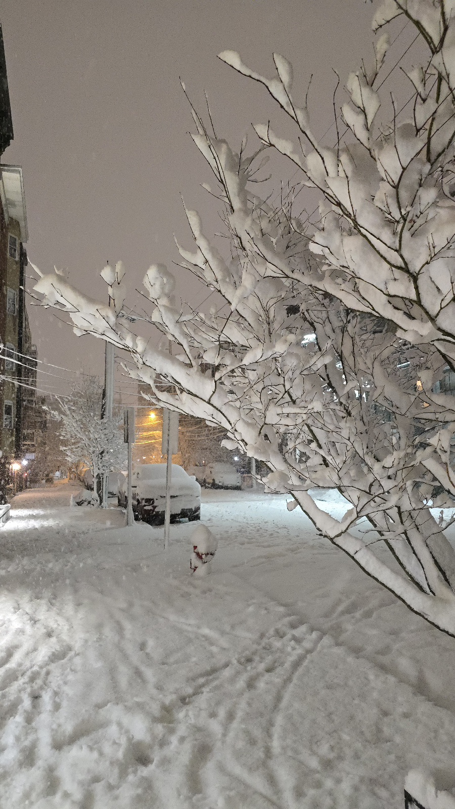
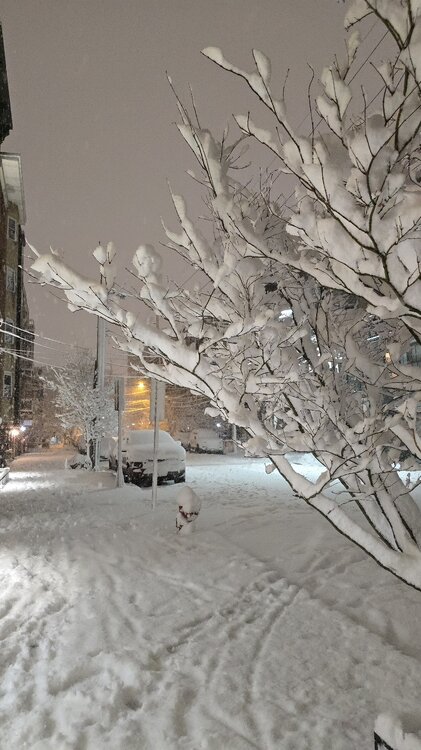
Not the best snow growth but it’s dumping here now! -
About to get wild in southern Fairfield Co with this band pushing ashore
-

"Don’t do it" 2026 Blizzard obs, updates and pictures.
Hoth replied to Ginx snewx's topic in New England
On my doorstep. Already nuking. -
"Don’t do it" 2026 Blizzard obs, updates and pictures.
TalcottWx replied to Ginx snewx's topic in New England
Snowing hard af here too now. -

"Don’t do it" 2026 Blizzard obs, updates and pictures.
bobbutts replied to Ginx snewx's topic in New England
I think you'll get 15" or better. I'll never forget Bruce Schwoegler forecasting 20-30" and getting 1" on the North Shore MA as a kid. At least this one was always a tease up here. -
Maybe by 1am Heavy snow continues
-
"Don’t do it" 2026 Blizzard obs, updates and pictures.
Torch Tiger replied to Ginx snewx's topic in New England
yeah we've been near- saturated for a while, very very light precip since 7pm -

Feb 22nd/23rd "There's no way..." Obs Thread
Eskimo Joe replied to Maestrobjwa's topic in Mid Atlantic
Finally below 32 degrees in Reisterstown. -

Feb 22nd/23rd "There's no way..." Obs Thread
NorthArlington101 replied to Maestrobjwa's topic in Mid Atlantic
Slightly sketchy drive back into DC until you get to the DC line… then it’s like nothing happened. Probably 3”+ at home with that last push and literally just over a T on my deck in downtown. Friends don’t let friends move into DC -
2.5in on top of my car in Garrison
-
Somehow this one band came back here! Man I’m shocked! I really don’t hardly ever do this well in NW flow but then again there’s hardly ever a Nor’easter of this magnitude to the NE helping pull down cold air and moisture from the Great Lakes like this. Approaching a quarter inch on the car and grass!
-
7.3” here so far
-

"Don’t do it" 2026 Blizzard obs, updates and pictures.
RI Rob replied to Ginx snewx's topic in New England
Nothing so far in Boston. Bleh. -
Just lost power here in Hoboken
-
Band pushing into Bridgeport is nuts
-
Public Information Statement National Weather Service New York NY 1025 PM EST Sun Feb 22 2026 ...LATEST SNOWFALL REPORTS SINCE 8 PM 2/22... Location Amount Time/Date Provider ...Connecticut... ...Fairfield County... 4 S Greenwich 5.5 in 1005 PM 02/22 Public Norwalk 5.2 in 1013 PM 02/22 Storm Chaser 1 SE Norwalk 5.2 in 1000 PM 02/22 Trained Spotter 1 SE Wilton 5.0 in 0938 PM 02/22 Public 4 SSE Easton 4.0 in 0940 PM 02/22 Public 3 WSW Shelton 4.0 in 0840 PM 02/22 Trained Spotter 1 N Norwalk 3.2 in 0924 PM 02/22 Public ...Middlesex County... 1 SW Westbrook 6.0 in 1005 PM 02/22 Trained Spotter ...New Haven County... 3 NNE East Haven 3.5 in 0930 PM 02/22 Public 3 ENE Branford 3.0 in 0903 PM 02/22 Public Meriden 2.2 in 0941 PM 02/22 Storm Chaser ...New London County... 1 SSW New London 5.0 in 1007 PM 02/22 Trained Spotter 1 SSE North Stonington 1.8 in 0857 PM 02/22 Public ...New Jersey... ...Bergen County... Leonia 7.7 in 1014 PM 02/22 Public 1 SW Franklin Lakes 7.0 in 0925 PM 02/22 Public 1 E Ridgefield 6.8 in 0955 PM 02/22 Public 1 NNW Carlstadt 6.3 in 0920 PM 02/22 Public 1 SSW River Edge 5.7 in 1008 PM 02/22 Cocorahs Fair Lawn 5.5 in 1009 PM 02/22 Trained Spotter Little Ferry 5.0 in 1000 PM 02/22 Amateur Radio 1 WSW Wallington 4.6 in 0902 PM 02/22 Trained Spotter New Milford 4.0 in 0900 PM 02/22 Trained Spotter Northvale 2.6 in 0803 PM 02/22 Public ...Essex County... North Caldwell 6.1 in 1000 PM 02/22 Amateur Radio Nutley 4.5 in 1000 PM 02/22 Amateur Radio 1 WSW Glen Ridge 4.0 in 0840 PM 02/22 Public Bloomfield 3.0 in 1000 PM 02/22 Amateur Radio ...Hudson County... Hoboken 5.3 in 0930 PM 02/22 Trained Spotter Harrison 5.0 in 0934 PM 02/22 CO-OP Observer Bayonne 4.5 in 1000 PM 02/22 Amateur Radio Kearny 3.7 in 0915 PM 02/22 Trained Spotter ...Passaic County... Clifton 3.9 in 1000 PM 02/22 Amateur Radio Wayne 3.5 in 1000 PM 02/22 Amateur Radio ...Union County... 1 SSW Westfield 6.0 in 0924 PM 02/22 Public 1 N Cranford 6.0 in 0923 PM 02/22 Public Newark Airport 4.0 in 0800 PM 02/22 Official NWS Obs ...New York... ...Kings County... 3 NW Flatbush 6.9 in 0915 PM 02/22 Public 1 WSW Gravesend 6.1 in 0832 PM 02/22 Public Crown Heights 6.0 in 0953 PM 02/22 Public 1 SE Battery Park 4.9 in 0905 PM 02/22 Emergency Mngr 1 N Bay Ridge 4.1 in 0804 PM 02/22 Public Sheepshead Bay 3.5 in 0813 PM 02/22 Trained Spotter ...Nassau County... 1 SSW Baldwin 7.0 in 0939 PM 02/22 Public East Williston 6.7 in 0929 PM 02/22 Public 1 N Syosset 6.6 in 0900 PM 02/22 Trained Spotter 1 WSW Levittown 6.2 in 1000 PM 02/22 NWS Employee 2 SSE Plainedge 6.0 in 0815 PM 02/22 Trained Spotter 1 NNW Bethpage 5.3 in 0852 PM 02/22 Public Lake Success 5.1 in 0825 PM 02/22 Public Rockville Centre 5.0 in 0922 PM 02/22 Public Manhasset Hills 3.1 in 0800 PM 02/22 Public ...New York (Manhattan) County... Washington Heights 6.3 in 0936 PM 02/22 Public ...Orange County... 1 WNW Monroe 3.5 in 0900 PM 02/22 Trained Spotter 2 SSW Middletown 2.0 in 0930 PM 02/22 Amateur Radio ...Queens County... 1 SW Bayside 7.1 in 1000 PM 02/22 Public 1 S Jackson Heights 7.0 in 1003 PM 02/22 Trained Spotter Flushing 6.0 in 0942 PM 02/22 Trained Spotter 1 NE Elmhurst 4.8 in 0800 PM 02/22 Public 1 E Fresh Meadows 4.5 in 0942 PM 02/22 Public 1 SSW Elmhurst 4.0 in 0815 PM 02/22 Public ...Richmond County... Dongan Hills 6.0 in 0800 PM 02/22 Public ...Rockland County... 1 SE Montebello 3.8 in 0836 PM 02/22 Public Nyack 3.0 in 0905 PM 02/22 Trained Spotter Thiells 2.5 in 0900 PM 02/22 Trained Spotter New City 2.2 in 0900 PM 02/22 Trained Spotter
-
Big dog potential always gets folks excited. The nickels and dimes less so…but definitely more snow-covered days so there’s that.
-

"Don’t do it" 2026 Blizzard obs, updates and pictures.
NeonPeon replied to Ginx snewx's topic in New England
You can see how these bands are going to pivot now, but the have and have lesses... Undetermined. I have my guess though. Up to 2 inches. Very very wet.