All Activity
- Past hour
-
with some small exceptions like 1933-34, 1942-43, 1947-48. Those were some very cold/snowy winters!!
-
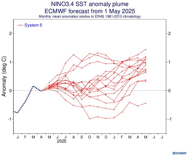
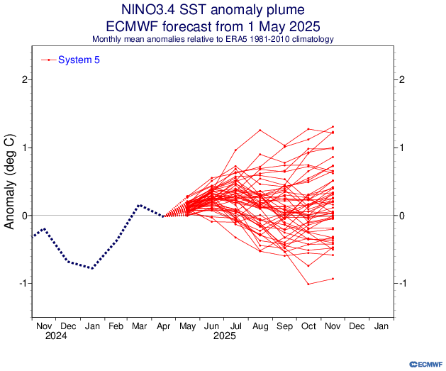
May's Euro does favor a Niño for 26/27. But that's got to be low skill.
-
-NAO is now shifting to MAM while +NAO predominates in DJF. Actually scratch March, now DJFM are all +NAO while -NAO is now AM
-
20” at Norwalk seems highly sus.
-

OBS for OKX Flood Watch (attached) into early Saturday 5/10/25
wdrag replied to wdrag's topic in New York City Metro
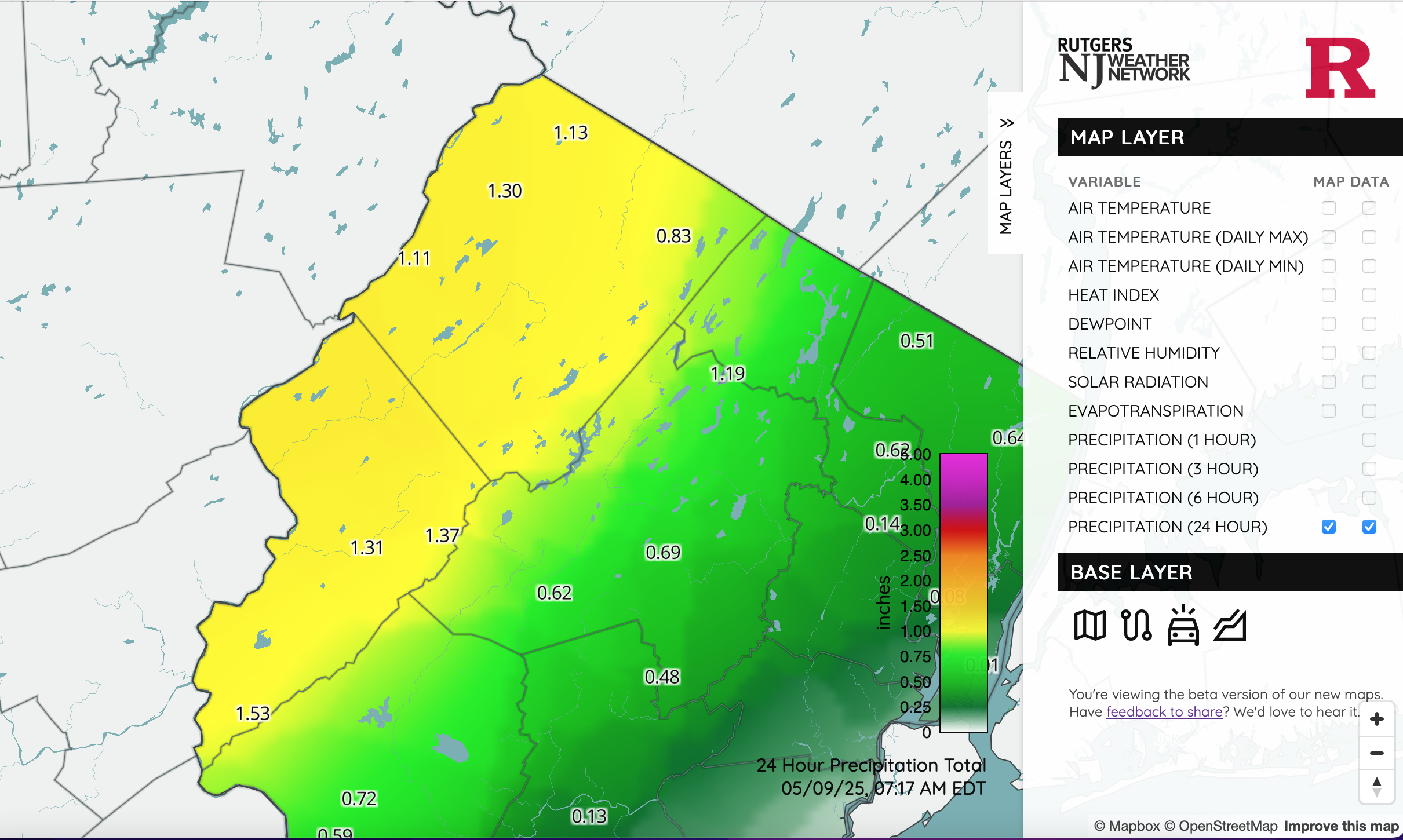
I still dont quite understand the Watch in our area and its expansion but going with it. NYS mesonet all under 1" so far. NJ however, this is legit. Click for clarity. Wantage fits with at least 1.34 so far... needed.
-
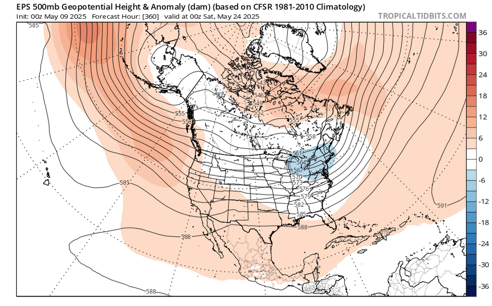
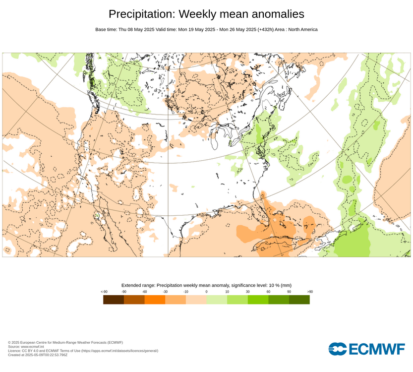
The extended EPS has this rainy pattern into late May. We may continue the recent years pattern of rain on at least one of the Memorial Day weekend days. As the upper low will still be near the Northeast.
-
Im already sitting at 1.67” since last evening in Lebanon with moderate rain continuing .
-
Looks like heaviest stays west of 84? Looks like that narrow band of heavier rain of the NJ coast gets eastern areas
-
yeah if you took away the modeled stuff yesterday aftn it was pretty much 1-2.
-
Euro's May Enso update taking the shotgun approach.
-
-
Records: Highs: EWR: 93 (2000) NYC: 94 (1979) LGA: 92 (2000) JFK: 86 (2000) Lows: EWR: 33 (1947) NYC: 3 (2020) LGA: 36 (2020) JFK: 34 (2020) Historical: 1894: Portland, OR had its latest freeze when the temperature fell to 32°. This is the only May freeze in Portland's history. 1966 - Record snows fell in the northeastern Ohio and western Pennsylvania, including 3.1 inches at Pittsburgh PA and 5.4 inches at Youngstown OH. Snow also extended across parts of New York State, with eight inches reported in the southern Adirondacks. (The Weather Channel) 1977 - A late season snowstorm hit parts of Pennsylvania, New York State, and southern and central New England. Heavier snowfall totals included 27 inches at Slide Mountain NY and 20 inches at Norwalk CT. At Boston it was the first May snow in 107 years of records. The heavy wet snow caused extensive damage to trees and power lines. The homes of half a million persons were without power following the storm. (9th-10th) (David Ludlum) (The Weather Channel) 1985 - Lightning struck some trees about 150 yards away from a home in Alabama, and followed the driveway to the home. The charge went through the house and burned all the electrical outlets, ruined appliances, and blasted a hole in the concrete floor of the basement. (The Weather Channel) 1987 - Unseasonably warm weather spread from the Pacific Northwest to the Upper Mississippi Valley. Fifteen cities reported record high temperatures for the date. It was the fourth day of record warmth for Eugene OR and Salem OR. (The National Weather Summary) 1988 - A massive cyclone in the central U.S. produced severe thunderstorms from eastern Texas to the Upper Ohio Valley. A strong (F-3) tornado ripped through Middleboro KY causing more than 22 million dollars damage. Thunderstorms in east central Texas produced hail three and a half inches in diameter at Groesbeck, and near Fairfield. (The National Weather Summary) (Storm Data) 1989 - Thunderstorms developing ahead of a cold front in the south central U.S. produced golf ball size hail and wind gusts to 62 mph at Mira LA, and during the morning hours drenched Stuttgart AR with five inches of rain. (The National Weather Summary) (Storm Data) 1990 - Thunderstorms produced severe weather in the central U.S. during the evening hours, mainly from southeastern Missouri to southwestern Indiana. Severe thunderstorms spawned four tornadoes, including two strong (F-2) tornadoes in southern Illinois. Strong thunderstorm winds gusted to 85 mph at Orient IL, and to 100 mph at West Salem. Thunderstorms drenched northeastern Illinois with up to 4.50 inches of rain. (The National Weather Summary) (Storm Data)
-
Yeah I could see the east end getting crushed again while further west gets slotted. We had that super persistent area of convection off the Jersey Shore with the last event too. Must be some sort of feedback with a Gulf Stream eddy.
-
58 / 56 light rain here / heaviest N+W. Still think we're good for 0.50 - 1.00 with areas N/W doubling or more than tripling thise amounts. Clear out Sat and make way for a nice weekend with Mothers Day and Mon the 12th approaching or into the low 80s. Next system cuts off into the south and slowly comes northeast between Tue - Thu with next round of rains. Beyond there the recent timing has been kind to weekend weather with perhaps another nice weekend 17-18. Ridging and more warmth , perhaps heat to close the last 1/3 of the month (in that period, not the whole 10 days).
-
Nice downpour currently
-
Not seeing it. The steady heavy rain is well NW and maybe the stuff developing over coastal NJ clips eastern LI. Many of us on LI probably get the shaft zone in between.
-
Elias deserves it. But it won’t be him.
-
They are on pace to lose 100+ games. Still no signs of life. Someone needs to take the fall.
-
I’m at 2.66”
-

E PA/NJ/DE Spring 2025 Obs/Discussion
LVLion77 replied to PhiEaglesfan712's topic in Philadelphia Region
1.31” overnight thus far, which beats my 1.00” all last weekend. Mighty cool at only 53.6F this am. . -
Ya I don't see anything more humid or warmer than this past week, looks like 65-75 everyday the next 2 weeks.. In terms of the rain, looks like a quick hit of heavy rain honestly, Hi res starting to ramp back up for here 1-2" .. Don't see the widespread 2-3" though once forecast..
-

OBS for OKX Flood Watch (attached) into early Saturday 5/10/25
steve392 replied to wdrag's topic in New York City Metro
Moderate rain started falling the minute I hit route 80 for work. Steady rain now in Mahwah. Stuff is slow moving too. -
I don’t think these problems are his fault, but he probably will be the sacrificial lamb.
-
Looks meh. Mostly overnight lows. No heat. No install.
-
Not a single drop.