All Activity
- Past hour
-

December 14th - Snow showers or Plowable snow?
SouthCoastMA replied to Sey-Mour Snow's topic in New England
4-6" on Cape. LFG -
Nice big dendrites mixing in now with the smaller flakes. This is fluffy AF so will pile up nicely.
-

12/14: Sunday funday? Will the south win again?
Maestrobjwa replied to TSSN+'s topic in Mid Atlantic
Maybe it will take a little more for the city...still at 38 here it seems. -

December 2025 Short/Medium Range Forecast Thread
Matthew70 replied to John1122's topic in Tennessee Valley
You can see the signs showing as Carver has said. The warm ups are more seasonal as they get closer. Active pattern seems to be showing its hand around Christmas & after. That really cold air is staying on this side of the globe. -

Central PA Winter 25/26 Discussion and Obs
Blizzard of 93 replied to MAG5035's topic in Upstate New York/Pennsylvania
18z Euro with its best run yet for the event for the Harrisburg area with bringing 3 inches of Non-Advised snow tonight.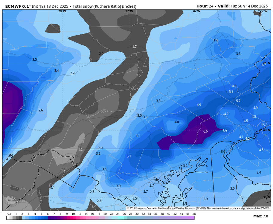
-
12/14: Sunday funday? Will the south win again?
Maestrobjwa replied to TSSN+'s topic in Mid Atlantic
Yes I realized that a few mins ago, haha -
35 here too. Dew at 29. Don’t think temps will be an issue
-
He was lost...but not forgotten. Glad to see ya'!
-
He's in Philly.
-
Steady Light snow and 35 in Pen-Mar, MD.
-
12/14: Sunday funday? Will the south win again?
Maestrobjwa replied to TSSN+'s topic in Mid Atlantic
But why use that when we have access to all the actual weather models themselves? I mean you know how to use TT (tropicaltidbits) and pivotal's sites, right? -

December 14th - Snow showers or Plowable snow?
Damage In Tolland replied to Sey-Mour Snow's topic in New England
Nice map man. That’s how I envisioned it like 4-5 days ago and then models went south before bringing it back. Hopefully this works out for everyone -
Lowest maxima for Sunday and Monday for NYC DEC 14 _ 21 (1902), 22 (1888), 23 (2010), 24 (2005), 26 (1903,1904), 27 (1898), 28 (1933) DEC 15 _ 20 (1874,1914), 22 (1917), 25 (1871), 26 (1903), 27 (1919, 1962, 2010), 28 (1904, 1905, 1916, 2017) Lowest minima for Monday DEC 15 ___ 8 (1874), 9 (1883), 10 (1914, 1917), 13 (1900, 1902), 14 (1910, 1943, 1962), 15 (1904, 1921) __ 18 (1980, 2005) coldest recent years Heaviest snowfalls 13-14 (2d totals include all > 1.0") 1917 _9.5" (8.0+1.5) 1902 _6.1" (6.0" 13th, 0.1" 14th) 1915 _6.0" (5.0+1.0) 2003 _5.8" (all on 14th) 1889 _5.5" (all on 14th) 2013 _5.0" (all on 14th) 1942 _4.1" (all on 13th) 1922, 1945 _3.2" (all on 14th) 1904 _2.8" (on 13th, followed 4.2" on 12th for 7.0" total) 1951 _2.5" (all on 14th) +0.8" 15th = 3.3" total 1933 _2.2" (2.0+0.2) 1995 _1.7" (all on 14th) 1892 _1.5" (all on 13th), 1893 and 1907 _1.5" (all on 14th) 1981 _1.4" (all on 14th) 1923, 2017 _1.2" (all on 14th) _ 2017 added 1.2" 15th for 2.4" total. 1909 _1.0" (all on 13th)
-
Lol rain. This is big boy shit. We aren't dealing with rain here lad.
-

Moderate snowfall 12/14/2025 WWA up for most of the area
psv88 replied to WeatherGeek2025's topic in New York City Metro
Started as snow here too, 37/27 -
Bee drizzling here in Frederick for the last 30ish minutes.
-
Storm after storm, followed by cold....at that rate I would be ok with Tip's flowers by February
-
(002).thumb.png.6e3d9d46bca5fe41aab7a74871dd8af8.png)
Saturday night/Sunday 12/13-12/14 Jawn
ChescoWx replied to Ralph Wiggum's topic in Philadelphia Region
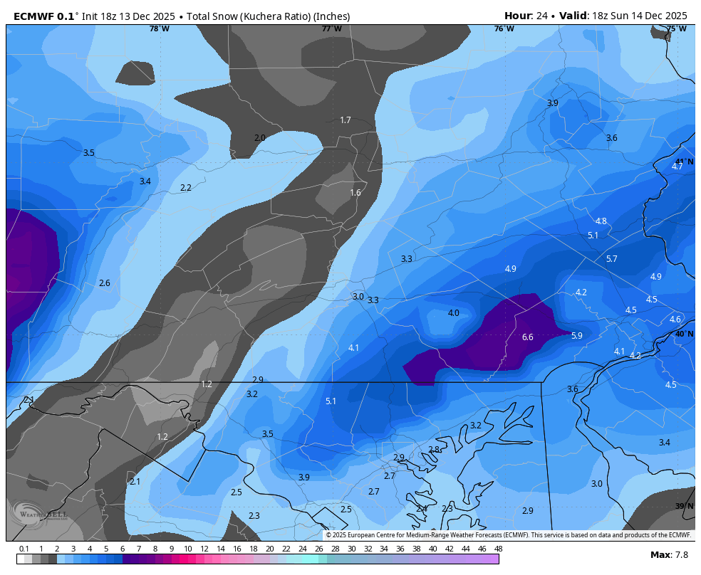
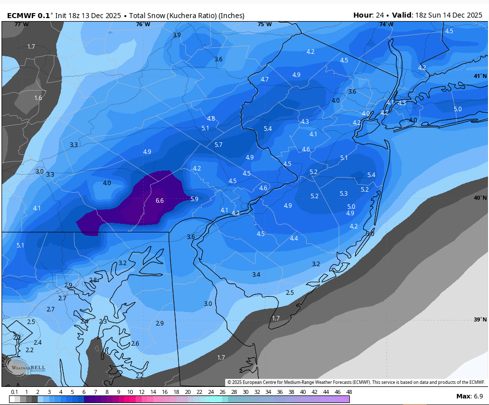
Latest European jackpots chescowx land....but alas we do not shovel model snow!
-
 grok_video_2025-12-13-18-40-20.mp4
 -
December 2025 Short/Medium Range Forecast Thread
Matthew70 replied to John1122's topic in Tennessee Valley
I remember they had snow drifts into July that year. Truly incredible to think it lasted that long. -

12/14: Sunday funday? Will the south win again?
JenkinsJinkies replied to TSSN+'s topic in Mid Atlantic
It’s gotten rain right more often than not in recent years at the local level. -

Moderate snowfall 12/14/2025 WWA up for most of the area
rclab replied to WeatherGeek2025's topic in New York City Metro
Snowing by street light on Tompkins Place. As always …. IMG_1836.mov -

Saturday night/Sunday 12/13-12/14 Jawn
Birds~69 replied to Ralph Wiggum's topic in Philadelphia Region
Enjoy! Couldn't be a better time for this to happen. A Bird's win tomorrow with complete the weekend... -
Apple weather app lol. Holy Shit. And you are an actual weather hobbyist?
-

December 2025 Short/Medium Range Forecast Thread
Daniel Boone replied to John1122's topic in Tennessee Valley
I agree completely man. NEPAC and western ridge squeeze play of the Pac Jet forcing downsloping imo. Also helping force that ridge to elongate eastward somewhat. Allows for Chinooks. If HLB sets up , even if that Pac Jet atmospheric ruver were to continue, it's going slow and back and buckle the Flow to some degree, whether alot or some depending on Blocking Strength.