All Activity
- Past hour
-
Monthly Departures: EWR: -3.6 NYC: -4.4 LGA: -4.8 JFK: -4.9
-
Thanks, figured. Only reason I included it is because it's not that far off from the surrounding 18-19" reports. I'll be doing a third update tomorrow If you have any more you think are sus or missing lmk
-
Blue Hill had 17 on the ground day before 24 total day of 28 otg next day. Its science
-
Today's split EWR: 55 / 30 (+5) NYC: 54 / 33 (+5)
-
-
Precisely.
-
Not only that, but the additional hour comes at the warmest time of the day.
-
Why do I care what they have? They are including ridiculous amounts in their PNS.
-
Tossed
-
Sure I am. That's one whole additional hour of the sun warming the ground.
-
Thanks. What's your thoughts on that 22.5 in S. Harvard?
-
You do know that that is a function of a human clock only and has no effect on length of day at all?
-
 March DCA _ NYC _ BOS _ ORD _ ATL _ IAH _ DEN _ PHX _ SEA 5.0 4.3 3.8 5.0 5.8 5.2 3.0 3.7 0.8
 -

February 2026 OBS & Discussion
donsutherland1 replied to Stormlover74's topic in New York City Metro
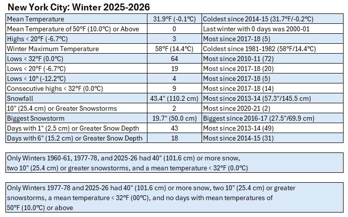
February 2026 is finishing with a mean temperature of 31.5°, which is 4.4° below normal (1991-2020 baseline). It would also be 3.8° below the 1981-2010 baseline. Winter 2025-2026 is finishing with a seasonal mean temperature of 31.9°. That is the coldest winter mean temperature since Winter 2014-2015 when the mean temperature was 31.7°. Winter 2025-2026 is only the fourth winter of the 21st century with a mean temperature of 32.0° or below. Winter 2025-2026 is just the third winter with two or more 10" snowstorms, a seasonal mean temperature of 32° or below and seasonal snowfall of 40.0" or above. The others are 1960-1961 and 1977-1978. Colder air will return for tomorrow through Tuesday. A light snowfall with coatings in places, especialy north and west of New York City, is possible tomorrow. Monday could see the temperature top out near or even below freezing in New York City after starting in the upper teens. After mid-week, a warming trend will commence. The second week of March could feature springlike readings. Long Island and coastal sections could be noticeably cooler than interior sections on a number of days on account of a chilly onshore flow. The ENSO Region 1+2 anomaly was +1.2°C and the Region 3.4 anomaly was -0.1°C for the week centered around February 11. For the past six weeks, the ENSO Region 1+2 anomaly has averaged +0.37°C and the ENSO Region 3.4 anomaly has averaged -0.32°C. Neutral ENSO conditions have now developed. Neutral ENSO conditions will continue through at least mid-spring. The SOI was +17.10 today. The preliminary Arctic Oscillation (AO) was -0.236 today. -

Outta gas and Outta Time: Early March Winter Storm finale
Warm Nose replied to Ji's topic in Mid Atlantic
By comeback, you mean you're going to Houston, right? -
 DCA _ NYC _ BOS _ ORD _ ATL _ IAH _ DEN _ PHX _ SEA 4.8 3.4 2.4 3.2 4.7 4.8 1.8 0.4 -0.4
 -
Your not serious are you
-

February 2026 OBS & Discussion
WestBabylonWeather replied to Stormlover74's topic in New York City Metro
Terrific winter. A+ cold. Ice waterways with ice skating extended snow cover we won. Ready for spring. note - to have a good winter the west has to torch -

E PA/NJ/DE Winter 2025-26 Obs/Discussion
Ralph Wiggum replied to LVblizzard's topic in Philadelphia Region
Tomorrow AM btw: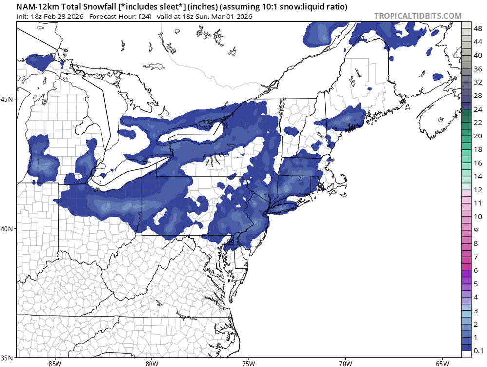
-
Not only that,with the extra hour we get from daylight savings time starting next Sunday it's going to be even harder for snow to stick around.
-
Bluewave posted this. Great winter we had
-
Not ready for spring yet, but the march is just about underway.
-
Their current closing date is April 5. I know they have to close before the 15 due to their deal with the state.
-
It wasn't even rain. Just nothing. But it came back in the 18z suite. Hopefully it stays there.