All Activity
- Past hour
-

2026-2027 Record-breaking El Nino
csnavywx replied to Stormchaserchuck1's topic in Weather Forecasting and Discussion
No surprise the CFS is having problems here. It's been having issues maintaining the initialized thermocline slope for a while now -- hence the reason it continues to underforecast Nino 1+2. Some of that may be related to the model's native climo, and/or a bias towards reverting towards stronger easterlies. This is particularly important for a very strong, very east-based event. -
I just look at 72-73,82-83,97-98 and 15-16..those are warm winters..those are the strong ninos of the past 50 years.Doesnt mean it cant snow..but many here will be complaining in December and January with temps in the 50s and rain, like we were those winters.
-
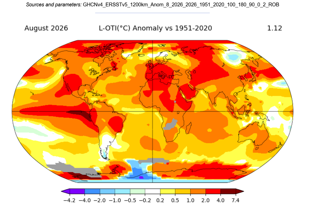
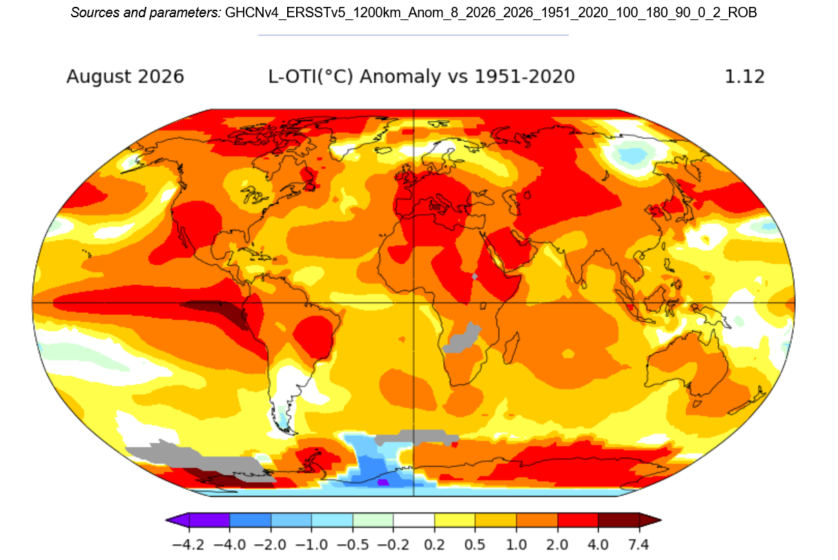
Had AI summarize an update based off the latest August readings. : ENSO 2026 The latest August readings show Niño 3.4 near +1.9°C, Niño 3 near +2.8°C, Niño 1+2 over +3.0°C, and Niño 4 still warm in the PSL dataset. MEI.v2 is also very strong at +2.54, while RONI is up to +1.67. The key point is that this is not just a weak or central-Pacific event right now. The current structure still looks very east-Pacific to east-central-Pacific, with some basinwide support depending on which Niño 4 dataset is used. Parameter Latest 2026 Reading Period What It Shows Niño 3.4 +1.89°C PSL / +1.8°C CPC Aug 2026 Strong; near very strong threshold Niño 3 +2.83°C PSL / +2.5°C CPC Aug 2026 Very strong east-central warming Niño 1+2 +3.28°C PSL / +3.4°C CPC Aug 2026 Extreme far-eastern Pacific warmth Niño 4 +1.29°C PSL / +0.1°C CPC Aug 2026 Dataset-dependent; PSL basinwide warm, CPC relative index lower RONI +1.67 Aug 2026 Strong relative Niño 3.4 signal ONI +1.80 Latest available Strong 3-month oceanic El Niño MEI.v2 +2.54 Aug 2026 Very strong coupled ocean-atmosphere signal SOI -4.00 Latest available July value Very strong atmospheric El Niño response OLR -1.00 Aug 2026 Enhanced tropical convection Heat Content +2.75 Aug 2026 Strong subsurface warm support 200mb Zonal Winds -6.44 Aug 2026 Strong upper-level easterly anomaly Looking at the August SST structure, 1997 still comes out as the best overall match because of the very strong east-Pacific signal. August 2026 is actually warmer than August 1997 in Niño 3.4, but 1997 remains a strong match in Niño 3 and Niño 1+2. 2015 is the best basinwide/intensity analog, especially with the warmer Niño 4 support. 2023 remains a useful recent analog for the eastern-Pacific SST shape, but it was much weaker on the coupled-atmosphere side at the same point. Rank Analog Year Aug Niño 3.4 Aug Niño 3 Aug Niño 1+2 Aug Niño 4 Match to Aug 2026 Baseline 2026 +1.89 +2.83 +3.28 +1.29 Current 1 1997 +1.40 +2.60 +3.64 +0.67 Closest east-Pacific structure; very strong Niño 3 / 1+2 match 2 2015 +1.49 +1.87 +1.73 +1.04 Best basinwide/central support match; weaker eastern zones than 2026 3 2023 +1.20 +1.88 +2.54 +0.90 Good recent east-Pacific analog, but weaker Niño 3.4 and coupling 4 1982 +0.44 +0.83 +0.89 +0.13 Poor August SST match, but major-event trajectory later 5 1972 +0.73 +1.60 +2.00 +0.06 Good east-Pacific analog, much weaker Niño 3.4 / Niño 4 6 1965 +0.68 +0.96 N/A N/A Useful historical analog, but weaker August intensity 7 1957 +0.81 +1.20 N/A N/A Strong older event, but weaker than 2026 in August 8 1991 +0.73 +0.63 +0.18 +0.56 Warm/coupled event, but far weaker east-Pacific structure 9 2002 +0.67 +0.40 +0.12 +0.65 More central/basinwide, not close to the east-Pacific warmth 10 2009 +0.61 +0.72 +0.75 +0.64 Developing El Niño, much weaker than 2026 The coupling side is also impressive. MEI.v2 for August 2026 is +2.54, which is higher than August 1997, 2015, and 1982. That is a major reason this event should not be dismissed as just ocean warmth without atmospheric support. SOI was also extremely negative in July, though the August SOI value was not available in the same dataset at the time of comparison. On the coupled ocean-atmosphere side, 1997 and 2015 remain the strongest matches, with 1982 still important as a major-event trajectory analog. Rank Analog Year MEI.v2 Aug RONI JJA / Latest Coupling Match Baseline 2026 +2.54 +1.67 latest Current 1 1997 +2.27 +1.8 Very close; strongest full coupling analog 2 2015 +1.95 +1.5 Very strong, but weaker than 2026 3 1982 +1.91 +1.1 Strong; event exploded later 4 1972 N/A +1.4 Strong RONI trajectory; pre-MEI.v2 5 1991 +0.37 +0.8 Weaker coupling at same time 6 1994 +0.88 +0.6 Moderate coupling, less similar 7 2002 +1.01 +0.8 Moderate, weaker than 2026 8 2009 +0.56 +0.4 Much weaker 9 2023 +0.51 +0.8 Much weaker coupled signal at same point 10 1986 +0.97 +0.6 Slower-developing event Overall, I would rank the analog package as 1997–98 first, 2015–16 second, 2023–24 third for SST structure but lower for coupling, then 1982–83 and 1972–73. The biggest takeaway is that 2026 is already running warmer than many of the classic strong El Niño years at the August checkpoint, especially in Niño 3.4 and MEI. The event still does not look like a classic Modoki right now because Niño 1+2 and Niño 3 remain extremely warm. If anything, the current look is more east-Pacific / east-central-Pacific with some basinwide support. Overall Rank Analog Current Match Why 1 1997–98 Best overall Best blend of very strong eastern-Pacific warmth, rapid strengthening, strong MEI, and major-event trajectory 2 2015–16 Very high Strongest basinwide/intensity analog; Niño 4 and Niño 3.4 support are good matches 3 2023–24 High for SST shape, lower for coupling Good recent east-Pacific SST analog, but much weaker MEI/SOI coupling at same time 4 1982–83 High trajectory analog Not close in August SSTs, but strong historical major-event analog by fall/winter 5 1972–73 High secondary Classic east-Pacific El Niño, but weaker Niño 3.4 and Niño 4 in August 6 1965–66 Moderate-high Useful historical east-Pacific/SOI analog, weaker SST intensity 7 1957–58 Moderate-high Strong older event, but August 2026 is already warmer 8 1991–92 Moderate Warm-event analog, but much weaker east-Pacific structure 9 2002–03 Moderate More central/basinwide and weaker eastern Pacific 10 2009–10 Lower-moderate El Niño winter analog, but weaker August development/coupling Bottom line: the latest August data keep 1997 as the best overall analog, 2015 as the best basinwide/intensity analog, and 1982 as a key major-event trajectory analog. 2023 is still useful for the east-Pacific SST pattern, but it is not nearly as good for coupling. Right now, this continues to look like a strong to potentially very strong east-Pacific / basinwide El Niño rather than a classic Modoki.
-
Great news. Zay is a minor injury and if it was a close game or playoff game he would have went back in. Wheww, i can now exhale.
-
I Lol great comeback Tony. Wet seems a lock white well it is winter.
-
The key will be whether it moves to west based later in the winter. East based, they're right we will roast ala 2015-16 (outside of 2 weeks)
-
If even people predicted a cold and snowy winter, its too early for winter predictions. This winter doesnt look as bad as people are making it out to be. This winter will not be as cold as last winter though.
-
I had a visit with my crazy mother this morning so I’m at Cushwa in Columbia raising my spirits.
-

Septorcher 2026 Discussion - Endless Summer
Ginx snewx replied to Damage In Tolland's topic in New England
COC -
.thumb.jpg.6a4895b2a43f87359e4e7d04a6fa0d14.jpg)
Central PA Summer 2026 Discussion/Obs Thread
Yardstickgozinya replied to Voyager's topic in Upstate New York/Pennsylvania
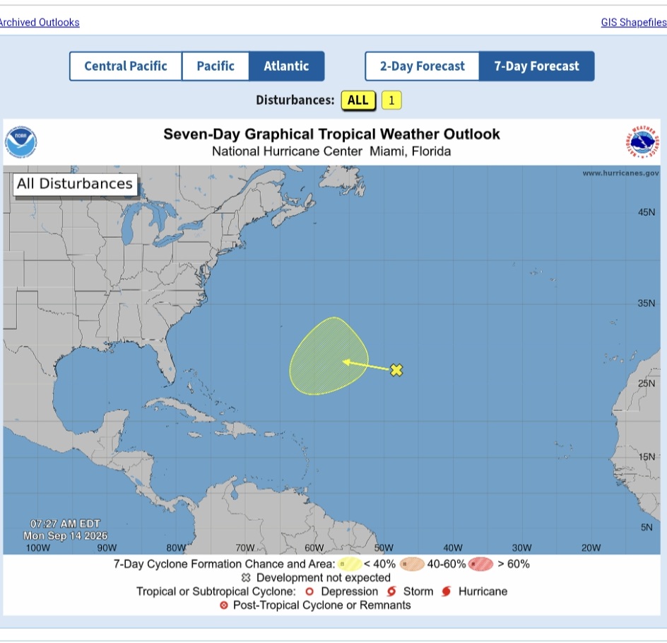
Here's something for you to watch. https://www.nhc.noaa.gov/gtwo.php?basin=atlc&fdays=7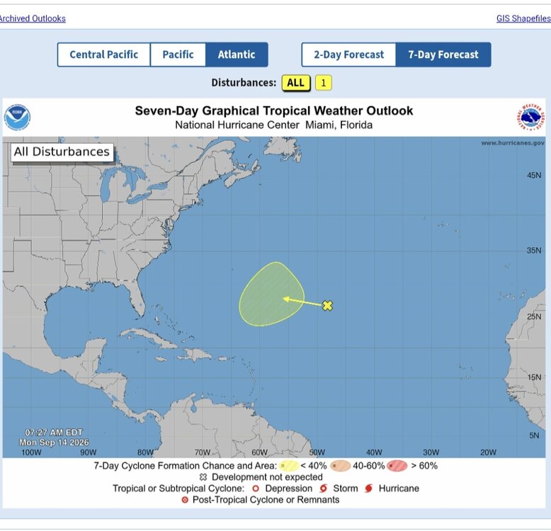
-
 https://indiagenericstore.shop/# buying medicine online in india
 -
I want another month, then 3 October’s, then Jan/feb, then 3 May’s. Deep fall and early spring are suspect here.
-
I got 0.02"
-
Huh? DEN had a low of 67 this am.
-

Septorcher 2026 Discussion - Endless Summer
ineedsnow replied to Damage In Tolland's topic in New England
lots of colors starting to pop in some areas.. beautiful crisp night incoming!! windows open and fan on.. I'll be sleeping like a baby while wifey looks for a 20th blanket -
mexican pharmacy official website and mexico pharmacy online ordering mexico pharmacy mail order online http://hanamura.shop/link.cgi?url=https://mexicogenerics.com reliable mexican pharmacies or http://www.1gmoli.com/home.php?mod=space&uid=1054538 mexican pharmacies that ship to the united states [url=https://cse.google.gg/url?sa=t&url=https://mexicogenerics.com]farmacia pharmacy mexico[/url] mexican pharmacy order online and [url=http://jonnywalker.net/user/kreaxiprap/]mexico pharmacy order online free shipping[/url] mexican pharmacies that ship
-
Bingo. Rarely see September change patterns these days. Hot dry crunchy leaves.
- Today
-
The dumbest choice for a shovel pass
-
Fall 2019 was similar, at least in turns of a long, drawn-out, hot fall with a sudden dramatic change in mid/late October. The heat wave culminated in the infamous "100 degree day" at RDU on October 3 (one of the first times I remember skepticism on this site with RDU being at least 2 degrees warner than any other site in the area). Within a relatively short amount of time after a 100 degree day, there were flurries somewhere in the state.
-

Septorcher 2026 Discussion - Endless Summer
Typhoon Tip replied to Damage In Tolland's topic in New England
-
-
Septorcher 2026 Discussion - Endless Summer
Ginx snewx replied to Damage In Tolland's topic in New England
Link to yours? -
Occasional Thoughts on Climate Change
Typhoon Tip replied to donsutherland1's topic in Climate Change
Mm... not going to defend that meme, no... however, it smacked me as more of the humorist voice - an attempt at sarcasm, perhaps sardonic giggles. I do that sometimes. I write something outlandish, with vivid descriptions of the physicality in dire consequences, over-the-top, as though people are in the room with me and can actually hear my tone of voice. Oops... It may be possible this was where he was coming from - if he had just said something like 'nyuk nyuk' on the end of it, you could hear that as Jay Leno-ism sarcastic barb -
What if there is blocking and a negative epo ?
-
what if there's never just enough cold because of the strongest el nino in history