All Activity
- Past hour
-
Why do you come to CT to golf ?
-
My goodness that cycle lasted for 30 years?? So "decadal" isn't so much a literal decade but just however many decades it lasts? (I'm sure you would've loved it back then...lol Although the 60s were snowy for the east)
-
I think that says more about your public safety officials than it does about me.
-
The odd thing is .. he comes to CT every week to golf .. then drives home drunk and stoned bad mouthing it.
-
It just dawned on me, those Mountain Dew commercials when they say everyone enjoys the dew, they’re not talking about the soda, they’re talking about high dews
-
Afternoon discussion from Sterling NWS summarizes the uncertainty with the end of the week outlook... Plenty of uncertainty remains in the extended period in regards to the placement and timing of a slow moving (nearly cutoff) upper level trough from the west and an area of low pressure working along the southeast U.S coast. These two features combined with the interaction of broad wedging high pressure off the northern New England coast/southern Canadian Maritimes will influence how much deep tropical moisture is funneling into the region. As of now, have went ahead and increased shower and thunderstorm chances (PoPs 30-50 percent), especially during the afternoon and evening hours Wednesday through Friday as onshore flow increases with the low pressure system just off the NC coast and an inverted trough nearby. Have backed off the rain chances for the upcoming weekend to around 15 to 30 percent. The 12z GFS/GEFS favors low pressure coming up along the coastal Carolinas and into eastern VA/Delmarva Friday into Saturday leading to increased shower and thunderstorm chances during this time. The 12z ECMWF/EPS favors more of the Thursday through Friday timeframe for tropical moisture as a strong baroclinic zone sets up over the region. The ECMWF/EPS is also more aggressive with high pressure wedging itself back into the area for the upcoming weekend allowing precipitation chances to decrease. The 12z Canadian is a blend of the two aforementioned solutions above along with central guidance. It still carries heavy probability of precipitation Thursday into Friday while lingering it into the weekend. With all said, specifics surrounding rain chances, amounts, and wind will continue to remain uncertain until models can get a better grip on the features at play. Increased onshore flow will remain leading to seasonably normal to slightly below normal temperatures and increased cloudiness throughout the extended period. Expect highs in the 70s and 80s with lows in the 50s and 60s.
-
Then on top of that, if the ONI ends up cold neutral but RONI is into Nina, does the ACE rule apply then? Neutral and weak are tough because there’s just so many competing influences on the pattern.
-
 Lol…Msc meriviglia. Left outta brooklyn this afternoon.
 - Today
-
Praise the Lord.
-
Just northeast is probably better than say.. 8 miles south. Just a guess.
-

2025 Spring/Summer Mountain Thread
Met1985 replied to Maggie Valley Steve's topic in Southeastern States
Stuck at 60 degrees and drizzle. Absolutely gorgeous weather out! -
Poor boomer Kevin…
-
We’re dope…
-
 90s are possible. I don’t think it will rival the late June and also peak July heat. The Atlantic might see 1-2 tropical cyclones, but the forecast pattern isn’t one that favors landfalls. A lot can still change given the lead time.
 -
82 but the sun is still summer fierce. It is hot in it.
-
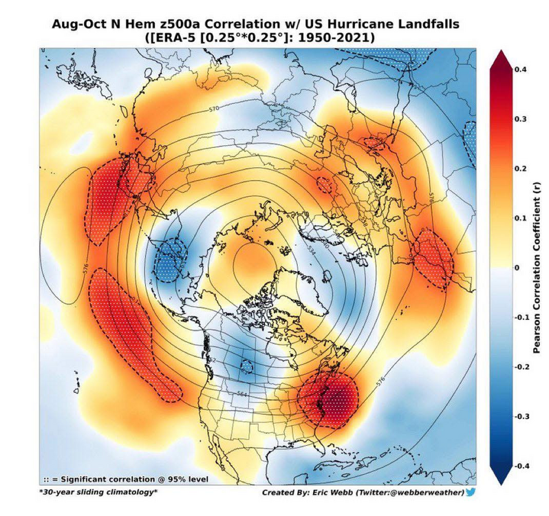
It might be a bit of ptsd, but I’m getting worried about this pattern ahead of an increasingly favorable Atlantic.
-
genetic link between hops and cannabis https://labelpeelers.com/label-peelers-blog/the-genetic-link-between-hops-and-cannabis-and-their-use-in-beer-making/?srsltid=AfmBOope_3aFPiT_F4hnQh7OTrOFeyDiqnjnORDrNWfzTfvzf4KKvxww
-
Fwiw-
-
 Don, does the August 15-20 period look particularly hot, any tropical activity? Thanks.
 -
It will turn briefly noticeably warmer for tomorrow and Tuesday before another somewhat cooler air mass arrives. Durng tomorrow, smoke could dim the sun at times and lead to air quality issues, especially north of New York City. The frontal passage will likely be dry for most of the region. The remainder of the week will see temperatures average somewhat below normal. A new round of heat could develop around or just after August 10th. Parts of the region could see a return of 90° or above heat. Extreme heat still appears unlikely. The ENSO Region 1+2 anomaly was +0.6°C and the Region 3.4 anomaly was -0.2°C for the week centered around July 23. For the past six weeks, the ENSO Region 1+2 anomaly has averaged +0.48°C and the ENSO Region 3.4 anomaly has averaged 0.00°C. Neutral ENSO conditions will likely continue through the summer. The SOI was -19.60 today. The preliminary Arctic Oscillation (AO) was +0.307 today.
-
Even though dews are still in the low 70s keeping it humid (so still sweating when the wind isn’t blowing), the steady NE winds along with overcast and only 81F near got me to take my first outside walk since early June I think. What’s interesting is that the winds off the 86F/30C ocean are not cooling winds. Right now they’re the opposite!
-
Well gang my time in Loudoun county is coming to an end. The wife and i are downsizing from our single family home and moving to....drumroll...to just northeast of Winchester. Target December...pray the rain snow hole disappears by the time I get out there. Oh by the way...HALF the cost
-
67 degrees, overcast and breezy. Sitting out back watching the race. Been a while that it's been this cold during the afternoon
-
 It’s great to have a boat but not with kids who have lots of activities. For me the boat is great without kids but when kids bring their friends and parents it becomes a chore and I am just a charter captain for the day working my ass off. Not fun. 85 today
 -
My numbers for July 2025 Averaged high temp was 86.3 degrees vs a normal of 83.9 degrees, a +2.4 degrees above average. The warmest temp recorded was 90.6 degrees on the 26th. Averaged low temp was 65.4 degrees vs a normal of 62.8 degrees, a +2.6 degrees above average. The coolest temp recorded for the month was 60.0 set on the 4th and 6th. Overall averaged temp was 75.9 degrees vs a normal of 73.4 degrees, a +2.5 degrees above average. Total rainfall for the month was 4.19 inches vs a normal of 4.01 inches, a +0.18 inches above average. The wettest day was the 10th with 1.55 inches falling. There were 17 days with measurable, 6 days with a 'T' and 8 dry days. Highest wind was on the 27th and 21st at 26 mph, but only 5 days had a wind at or above 25 mph. There were two new records, both 'warm minimums' set on the 30th and 31st. A warm to hot and very humid/muggy month with little temp variation. Every day had a high in the 80's except the 26th and 28th which barely crept above 90. Every night was between 60 and 70 degrees and many days/evenings with rainfall only adding to the mugginess.


