All Activity
- Past hour
-
34 again this am. Parkton Mesonet low was 30
-
But the models past 72 hours have been so bad that confidence is still low. No harm in waiting
-

Spooky Season (October Disco Thread)
dendrite replied to Prismshine Productions's topic in New England
It’s Halloween so who really cares. We’re just getting into graupel shower season. -
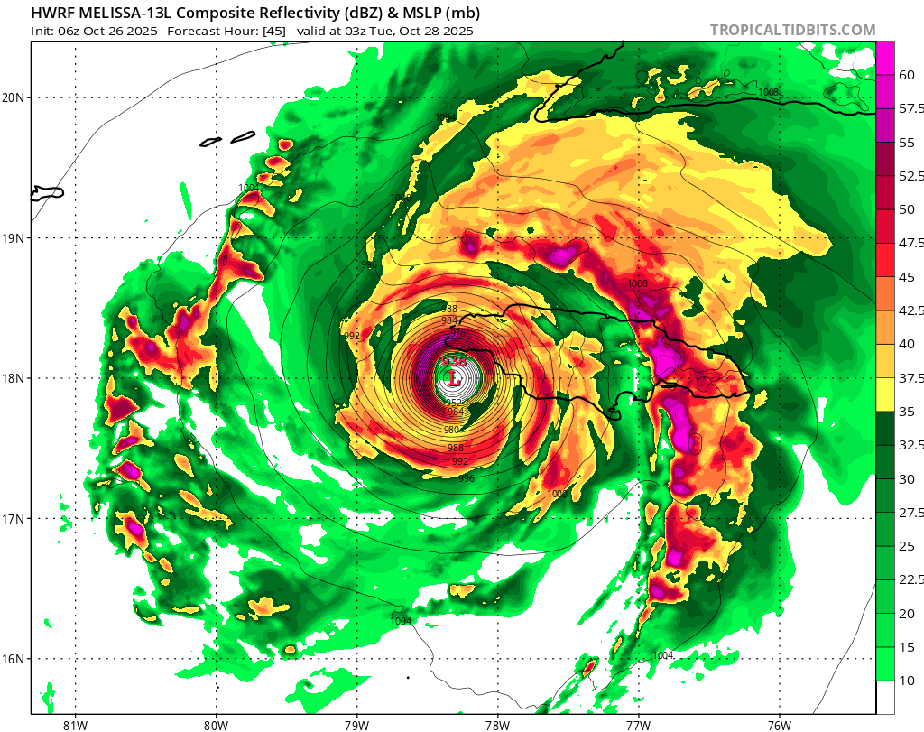
I'm no expert on the socioeconomics of Jamaica but I would guess the tourist areas would fare better than the higher poverty areas of Kingston. Kingston getting the worse of it would likely cause a humanitarian crisis.
-
Yup, I broke down again. I must be getting old
-
For what it’s worth this no longer looks like it will be a low ACE season.
-

Spooky Season (October Disco Thread)
Damage In Tolland replied to Prismshine Productions's topic in New England
The pattern ahead blows for any cold or early wintry chances. Nothing but puke Pacific air. -
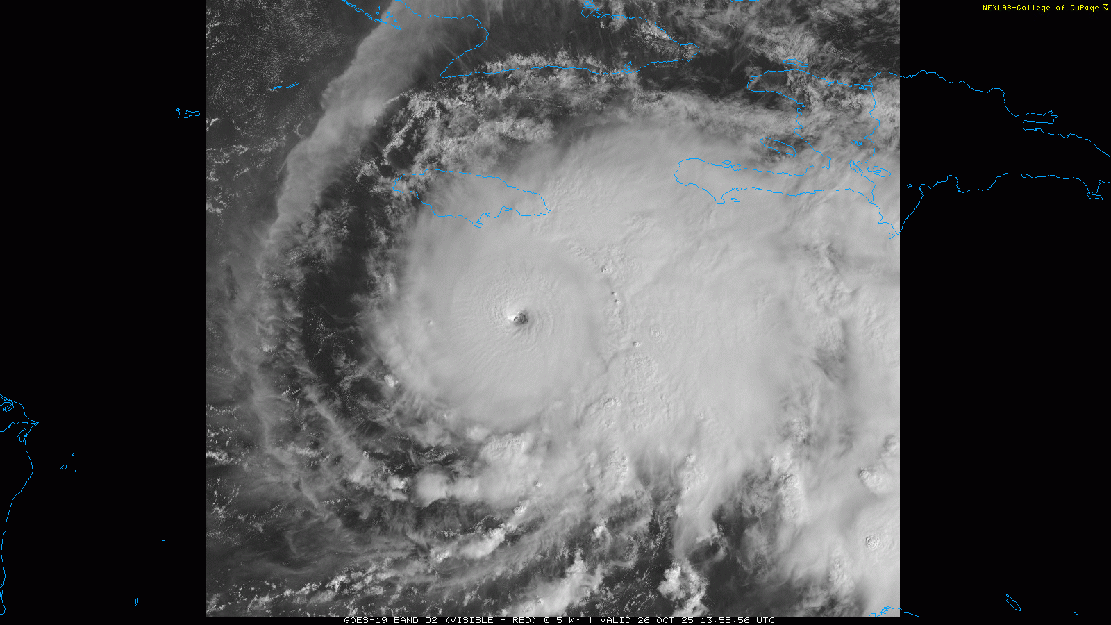
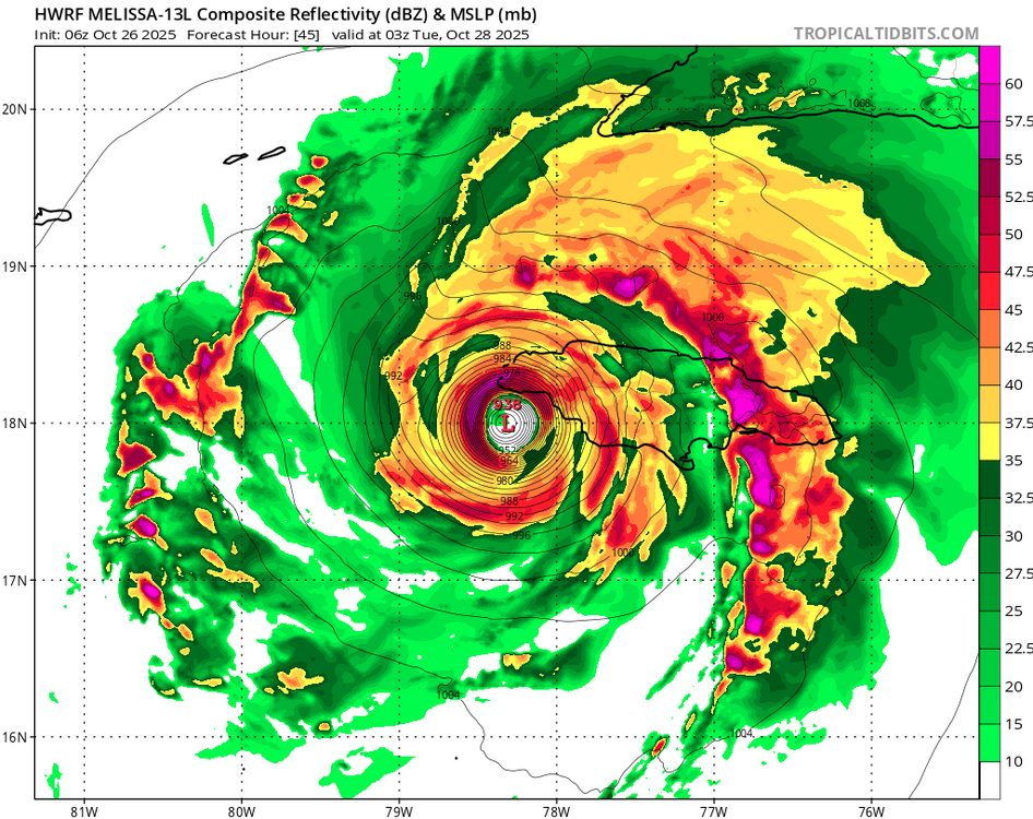
The last dropsonde found surface winds of 111kt with 128kt at 925mb in the northern section of the eyewall, so while potentially a little high, the NHC is in the ballpark. We’ll see what the next recon flight finds.
-
where do you get the EMI index/EMI forecasts?
-
Spooky Season (October Disco Thread)
dendrite replied to Prismshine Productions's topic in New England
35.6° for the min this morning…may go the next week without going below freezing. -
I posted the confusion emoji - because I am confused about exactly what triggers creating a storm thread now. I think there should be a storm thread created with emphasis on the Jersey Coast/ Long Island threats especially storm surge/flooding etc. etc. because as previously mentioned some areas have not fully recovered from the last storm 2 weeks ago. ALSO we still don't know exactly where that hurricane will track and its potential impacts on the coast combined with the coastal and or inland LP trough etc. etc. - I think inland areas will experience conditions similar to 2 weeks ago - agree or disagree ?
-
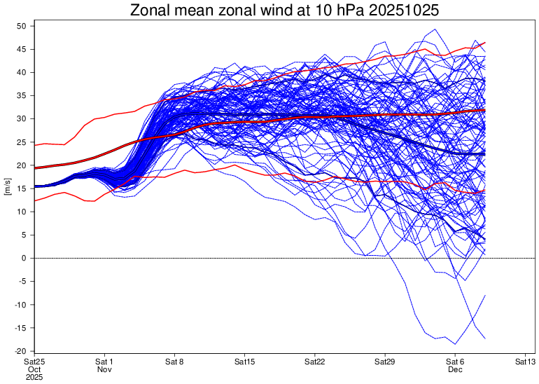
Idk. Over the next 40 day forecast period, the Eps weeklies has winds below normal around 2/3's of the time just eyeballin' it.
-
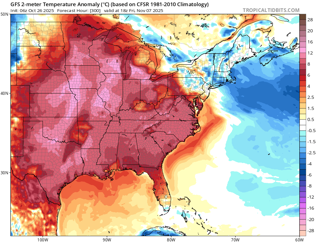
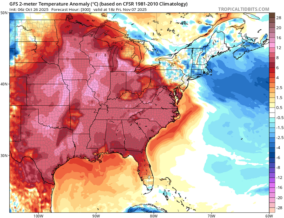
I'm seeing 80's middle to end of next week on the GFS. Its definitely a possibility.
-
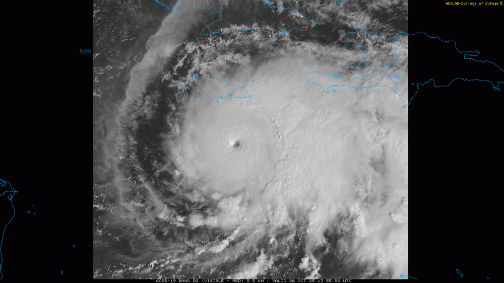
Amazing that this thing is still 36+ hours from landfall.
-
Most recent long-range radar image.
-

Central PA Fall Discussions and Obs
mahantango#1 replied to ChescoWx's topic in Upstate New York/Pennsylvania
I have a friend who just spent a week in Jamaica. He posted last night that he got out of there before they shut down the airports. But he has some other friends that didn't make it off the island before they shutdown the airports, so they are stuck there. -
Confusion emoji to me means uncertainty. Over the years of publishing for the NWS, I learned maybe a little... self discipline is a desired trait as is patience. While I think something, I prefer to be mostly correct in the expected reality--especitally D5. I'll have much more time this evening to balance the tipping point for a thread. Right now, our 06z/26 evaluated Average Return Interval for LGA is 9% for a 2 year or less return rate. That's not very high.
-
Spooky Season (October Disco Thread)
dendrite replied to Prismshine Productions's topic in New England
Ice generally needs a below freezing nucleus to form on so when that ice free day comes, we’ll have to refreeze the arctic from the outside-in which I would think would really slow refreeze up. As long as we have some slabs floating mid-ocean we can refreeze around those areas. The longer it’s open the more we’ll keep the moisture and heat flux going up there which will really hurt the source region for early winter. -
Last three days highs, 60, 56 and 57 yesterday. Next 7 days the forecast highs are between 49 and 56 and lows 36-40 with at least a chance of rain 5 of those 7, yep fall is here. Probably fire up the woodstove Monday or Tuesday for the first time.
-
.thumb.png.4150b06c63a21f61052e47a612bf1818.png)
Spooky Season (October Disco Thread)
HIPPYVALLEY replied to Prismshine Productions's topic in New England
Uhg! Let’s hope we can at least salvage the weekend. -
Some people make 1000s of posts, say every scenario possible, then claim they were able to identify the winter pattern in October. Its quite funny, and also shows they have a complex of some sort.
-
The western tracks by intensity models are easier on Kingston, but worse for tourist hubs Montego Bay and Negril.
-
3rd recon pass this morning continues to find a steady-state storm. The pressure is 953 mb, actually up a hair, and 120 kts flight level in the right (strongest) quad, which equates to 125 mph at the surface using the NHC's 0.9 method.
-

2025 Lawns & Gardens Thread. Making Lawns Great Again
jbenedet replied to Damage In Tolland's topic in New England
Agreed as I’m learning. Mines about 20 years old as I can tell from its about 30 ft size. Beautiful canopy that can expand out broadly as it can reach up to 100 ft high. I think the key is having it properly placed. Mine happens to be in a good spot where the falling walnuts are not a hazard. The walnuts produce juglone which nourishes the tree but is toxic to many competing plants. It’s also in a good spot on that front, as it’s in an area where neither me nor my neighbors want growth or meticulous landscaping. It’s all good at minimizing weed growth. -

Central PA Fall Discussions and Obs
canderson replied to ChescoWx's topic in Upstate New York/Pennsylvania
2nd day I’ve gotten lower than you - interesting. 34 here.