All Activity
- Past hour
-

July 2025 Obs/Disco ... possible historic month for heat
dendrite replied to Typhoon Tip's topic in New England
67.9/52 SCT A nice change of pace, COC day. -

July 2025 Discussion-OBS - seasonable summer variability
LoboLeader1 replied to wdrag's topic in New York City Metro
Spending the long July 4th holiday weekend with family & friends here in the Berks. Gorgeous outdoors, currently 71F under deep blue skies. Topped out at 92F yesterday back in HPN. -

Invest 92L--60% Two Day & 60% Seven Day Odds
GaWx replied to WxWatcher007's topic in Tropical Headquarters
Recon will take off at noon EDT and get into it during the early afternoon: SUSPECT AREA (OFF SOUTHEAST U.S. COAST) FLIGHT ONE - TEAL 71 A. 04/1800Z B. AFXXX 01BBA INVEST C. 04/1600Z D. 30.5N 79.5W E. 04/1730Z TO 04/2100Z F. SFC TO 10,000 FT G. LOW-LEVEL INVEST H. WRA ACTIVATION -
Perfection until all of the people showed up lol
-

July 2025 Discussion-OBS - seasonable summer variability
donsutherland1 replied to wdrag's topic in New York City Metro
2 consecutive days in 1948, not 3. -

Invest 92L--60% Two Day & 60% Seven Day Odds
WxWatcher007 replied to WxWatcher007's topic in Tropical Headquarters
It’s hard to tell via radar but there looks like there’s a fairly well defined low level circulation. -

July 2025 Discussion-OBS - seasonable summer variability
bluewave replied to wdrag's topic in New York City Metro
Yeah, unusually cool and wet July 4th following the snowiest winter of the 1970s. Climatological Data for ISLIP-LI MACARTHUR AP, NY - July 1978 Click column heading to sort ascending, click again to sort descending. 1978-07-01 78 58 68.0 -5.5 0 3 0.00 0.0 0 1978-07-02 73 55 64.0 -9.7 1 0 0.00 0.0 0 1978-07-03 70 60 65.0 -8.9 0 0 0.99 0.0 0 1978-07-04 61 56 58.5 -15.6 6 0 1.56 0.0 0 Climatological Data for JFK INTERNATIONAL AIRPORT, NY - July 1978 Click column heading to sort ascending, click again to sort descending. 1978-07-01 84 66 75.0 0.3 0 10 0.00 0.0 0 1978-07-02 78 57 67.5 -7.4 0 3 0.00 0.0 0 1978-07-03 71 60 65.5 -9.6 0 1 1.73 0.0 0 1978-07-04 65 60 62.5 -12.7 2 0 0.50 0.0 0 Snowfall Data for October 1, 1977 through April 30, 1978 Click column heading to sort ascending, click again to sort descending. NY PORT JERVIS COOP 70.5 NY PATCHOGUE 2 N COOP 68.7 NY ISLIP-LI MACARTHUR AP WBAN 68.0 CT DANBURY COOP 67.0 NY NY WESTERLEIGH STAT IS COOP 66.7 NJ PLAINFIELD COOP 65.2 NJ NEWARK LIBERTY INTL AP WBAN 64.9 NY MIDDLETOWN 2 COOP 64.7 CT MOUNT CARMEL COOP 64.1 NJ CHARLOTTEBURG RESERVOIR COOP 62.3 NY DOBBS FERRY-ARDSLEY COOP 61.6 NJ CRANFORD COOP 60.7 CT MIDDLETOWN 4 W COOP 60.2 NY WESTCHESTER CO AP WBAN 59.7 NY SCARSDALE COOP 59.6 NY BRIDGEHAMPTON COOP 59.1 NJ GREENWOOD LAKE COOP 59.0 NY NEW YORK AVE V BROOKLYN COOP 58.0 NY RIVERHEAD RESEARCH FARM COOP 57.5 NY YORKTOWN HEIGHTS 1W COOP 57.1 CT STAMFORD 5 N COOP 56.0 NY MINEOLA COOP 55.8 NJ WANAQUE RAYMOND DAM COOP 55.6 NY WALDEN 1 ESE COOP 54.2 CT IGOR I SIKORSKY MEMORIAL AIRPORT WBAN 52.7 NY NEW YORK LAUREL HILL COOP 51.6 NJ CANOE BROOK COOP 51.4 NY NY CITY CENTRAL PARK WBAN 50.7 NJ MIDLAND PARK COOP 49.1 CT GROTON COOP 48.9 NY JFK INTERNATIONAL AIRPORT WBAN 48.5 NJ TETERBORO AIRPORT WBAN 48.3 NY SETAUKET STRONG COOP 46.5 NJ LITTLE FALLS COOP 45.6 NY LAGUARDIA AIRPORT WBAN 43.5 -

July 2025 Discussion-OBS - seasonable summer variability
doncat replied to wdrag's topic in New York City Metro
Had a high yesterday of 92°.... Got done with the yard work just in time as thunderstorm followed with 0.27" rain and 39 mph gust . -

Invest 92L--60% Two Day & 60% Seven Day Odds
jbenedet replied to WxWatcher007's topic in Tropical Headquarters
Yea that’s a TS by looks on IR and vis satellite. Should get a name imminently. -
This -PDO being driven by the warm SST anomalies from Japan to north of Hawaii since 2019 is something new for us. The pattern has lead to warmer winters and record low snowfall due to the storm track through the Great Lakes and a faster Northern Stream of the Pacific Jet. Very amplified Aleutian Ridges have become the norm. It has also resulted in the Greenland blocking linking up with the Southeast Ridge. So strong subtropical ridges across the Pacific and Atlantic basins. The previous extended -PDO interval from 2007 to 2013 was more defined by the cold pool west of North America and a weaker warm pool east of Japan. Much weaker Aleutian Ridges and no Southeast Ridge in the East. So we didn’t have the Greenland blocking linking up with the Southeast Ridge. During the extended -PDO phase from 1950 to 1976 there was also a much weaker Aleutian Ridge along with much cooler SSTs in both basins. So there wasn’t any linkage between the Greenland blocking and Southeast Ridge.


-
Not in York yet, a couple more weeks, still in Mass on the CT border so I see CT fireworks too.
-

July 2025 Discussion-OBS - seasonable summer variability
LibertyBell replied to wdrag's topic in New York City Metro
Enjoy this great weather folks, looks like we get days of rain beginning next Tuesday? -
July 2025 Discussion-OBS - seasonable summer variability
LibertyBell replied to wdrag's topic in New York City Metro
How was it so cold in 1978? Raining all day? What was the low Chris? I don't see the high at JFK in this list, was it 65+ there? -
July 2025 Discussion-OBS - seasonable summer variability
LibertyBell replied to wdrag's topic in New York City Metro
Wow I wonder what they would have recorded on July 22, 2011.... In 2010 we maxed out in the low 100s here (three days). -
July 2025 Obs/Disco ... possible historic month for heat
dendrite replied to Typhoon Tip's topic in New England
The biggest anomalies in the extended could still be over SNE. Sites are already +5 to +7 coming in to today with big + anomalies Sun and Mon. BDL will probably be safe because the sensor is finally fixed but top 5 is still in play in most places. It only takes a few cool days to ruin it though. - Today
-
Scraps
-

E PA/NJ/DE Summer 2025 Obs/Discussion
LVLion77 replied to Hurricane Agnes's topic in Philadelphia Region
We need more rain like we need an STD. My goodness, it’s been feast or famine over the last several years. -

July 2025 Obs/Disco ... possible historic month for heat
kdxken replied to Typhoon Tip's topic in New England
Aaaaahhhh
-

Invest 92L--60% Two Day & 60% Seven Day Odds
Yanksfan replied to WxWatcher007's topic in Tropical Headquarters
Looking good on the latest imagery. I would imagine it will be classified as a TD/weak TS at 11am. -

July 2025 Obs/Disco ... possible historic month for heat
RUNNAWAYICEBERG replied to Typhoon Tip's topic in New England
For you and nne, sure. Still AN for sne but that’s par for the course these days. We can forecast AN every warm season month and look like a genius. -
If you were looking SSW from York probably Portsmouth...between 9:15-9:45 or so. Actually may be the last time they have them here due to budget cuts. Would need a private donor to pay for it.
-
Enjoy the 4th, all I got .15” rain yesterday in that little pop up storm.
-
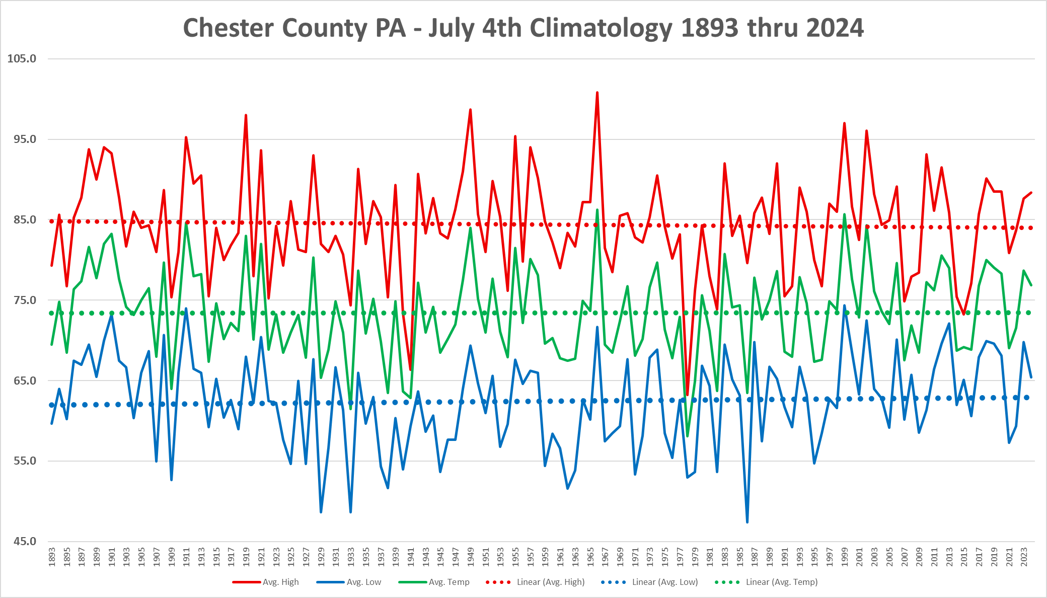
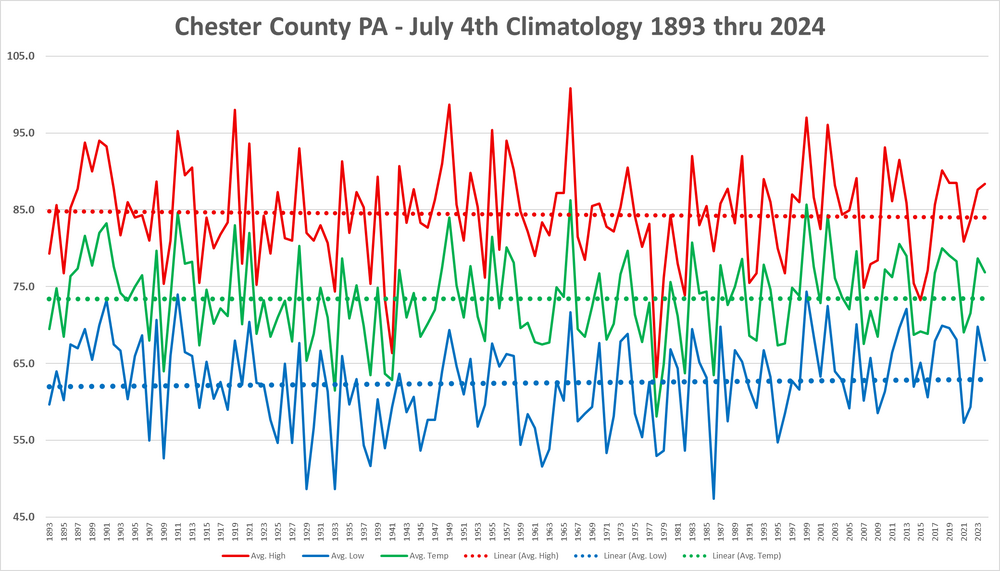
Happy 4th again! Below is an analysis of our climate here in Chester County for Independence Day. As you can see overall in our 132 years of weather records back to 1893 we have seen an overall slight cooling of our high temperatures and a slight warming of our low temperatures. Not surprisingly our average temperatures on the 4th of July have remained mighty constant with no warming or cooling on average over the last 13 decades of weather observations.
-

E PA/NJ/DE Summer 2025 Obs/Discussion
ChescoWx replied to Hurricane Agnes's topic in Philadelphia Region
Happy 4th again! Below is an analysis of our climate here in Chester County for Independence Day. As you can see overall in our 132 years of weather records back to 1893 we have seen an overall slight cooling of our high temperatures and a slight warming of our low temperatures. Not surprisingly our average temperatures on the 4th of July have remained mighty constant with no warming or cooling on average over the last 13 decades of weather observations.
-
Looked like a decent chance of rain a hour ago, gonna rain itself out before it makes it here. Sigh