All Activity
- Past hour
-

The “I bring the mojo” Jan 30-Feb 1 potential winter storm
KrummWx replied to lilj4425's topic in Southeastern States
Lolz. Either dry slot from hell and 2" or the jackpot, who knows?
-

E PA/NJ/DE Winter 2025-26 Obs/Discussion
PhiEaglesfan712 replied to LVblizzard's topic in Philadelphia Region
I was a junior in high school, taking the SATs that morning. It snowed pretty much the whole day, as far as I can remember. That was the last time a clipper (turned Nor'easter) really produced. 2026 joins 2005 and 2016 in the Conference Championship weekend snowstorms. Mark one down for 2036 or 2037 next? -
One thing we dont need is the ULL to trend weaker. That's one thing to really keep an eye out on now.
-

Possible coastal storm centered on Feb 1 2026.
subdude replied to Typhoon Tip's topic in New England
This morning was nuts. I had -15 in my truck at home so I went back in the house and 2 of my thermometers were at -14. Coldest day I have ever seen in Gardner. Drove to work in Fitchburg and it was 5 in the parking lot. -

February 2026 Medium/ Long Range Discussion: Buckle Up!
87storms replied to Weather Will's topic in Mid Atlantic
Chasing is tempting. -
The “I bring the mojo” Jan 30-Feb 1 potential winter storm
wake4est replied to lilj4425's topic in Southeastern States
This is a Miller A, not a Miller B. -

Winter 2025-26 Medium/Long Range Discussion
Chicago Storm replied to michsnowfreak's topic in Lakes/Ohio Valley
a lot of people do, surprisingly/unsurprisingly. -

February 2026 Medium/ Long Range Discussion: Buckle Up!
LeesburgWx replied to Weather Will's topic in Mid Atlantic
Heh, what a forecast for the Outer Banks. That's nuts -
The “I bring the mojo” Jan 30-Feb 1 potential winter storm
UpstateSCBud replied to lilj4425's topic in Southeastern States
It’s been a while since we’ve tracked a snowstorm like this, but it seems to be following so many of the “rules” I remember. Never want to be in the bullseye 3+days out. Always a west trend. Euro catches on first and GFS caves to it a couple days out. Obviously still a lot to iron out as far as totals, but folks in eastern NC definitely have every reason to be concerned given the trends. -

Possible coastal storm centered on Feb 1 2026.
Hailstoned replied to Typhoon Tip's topic in New England
It does seem in general that organized, coherent coastal lows as opposed to strung out disorganized synoptic situations, such as the present, have been lacking in recent years. (Due to the preponderance of fast flows Typhoon Tip often references?) We got away with a biggie this past weekend because it was less a storm and more a situation of exceptional overrunning. -

The “I bring the mojo” Jan 30-Feb 1 potential winter storm
Silver Meteor replied to lilj4425's topic in Southeastern States
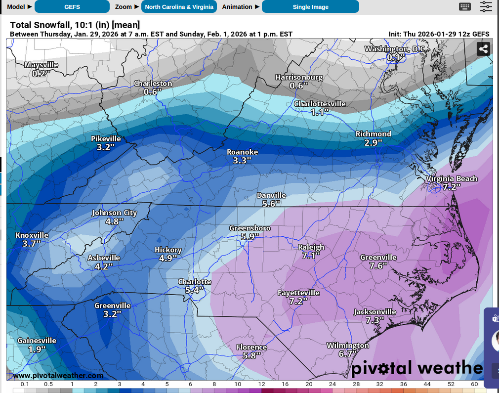
GFS also shows an all time record snowfall for the Cape Fear area. -

Possible coastal storm centered on Feb 1 2026.
RUNNAWAYICEBERG replied to Typhoon Tip's topic in New England
Canadian clips the outer cape with flurries. -

The “I bring the mojo” Jan 30-Feb 1 potential winter storm
olafminesaw replied to lilj4425's topic in Southeastern States
GEFS has the jackpot pretty much right over Wake county, so there's that (.7-.8 liquid) -

The “I bring the mojo” Jan 30-Feb 1 potential winter storm
franklin NCwx replied to lilj4425's topic in Southeastern States
It is if you live in the mtns -

Possible coastal storm centered on Feb 1 2026.
Typhoon Tip replied to Typhoon Tip's topic in New England
yet another way to metaphor it, we got *!@#ed in the ass -

The “I bring the mojo” Jan 30-Feb 1 potential winter storm
gman replied to lilj4425's topic in Southeastern States
When does the HRRR come out? -

The “I bring the mojo” Jan 30-Feb 1 potential winter storm
sakau2007 replied to lilj4425's topic in Southeastern States
3" of snow in my backyard would rank in the top 5 of events over the last 30 years. hard for me to take people seriously when they claim raleigh gets a snow shield if they have that kinda attitude! -

February 2026 Medium/ Long Range Discussion: Buckle Up!
Nomz replied to Weather Will's topic in Mid Atlantic
It should have been MEEEE -
Possible coastal storm centered on Feb 1 2026.
Typhoon Tip replied to Typhoon Tip's topic in New England
I never had a problem with this winter ..even before this last bigger snow producer. I just figured it for over-achieving on cold alone- I realize the demarcation is based upon snow fall, but that's endemic to these individuals and collective psychology amid this very niche' social media. We had early blocking ... we had snow threats. Some minor ones panned out. But a bigger event eventually transpiring was a parlay when we had/have a cold biased winter pattern persisting the way we did. Notice also ...we didn't get a bigger deal event until after the N. Pacific corruptive variant of the -WPO plaguing Dec was finally fully vanquished. That was a toxic relationship with that giant narcissistic block, LOL. Anyway, we got back to episodic -EPO bursts and allowed the Pacific to undercut for a coffee break and we get a STJ drive snow bomb out of it. Anyway, even if we didn't get this 15 to 20 incher, we probably would have ended up near normal by the end off 2-3" buck shot adding up over the long haul. So there... normal snow in a cold winter. The problem is... that psychology ^ ... people tend to judge the winters based on weather that they get that psychology masturbated or not. So that's really a different discussion entirely.. -

February 2026 Medium/ Long Range Discussion: Buckle Up!
Weather Will replied to Weather Will's topic in Mid Atlantic
We can still get a big storm in the Mid Atlantic; congrats Outer Banks! Washington-Tyrrell-Mainland Dare-Beaufort-Mainland Hyde-Northern Outer Banks- Including the cities of Plymouth, Manns Harbor, Manteo, East Lake, Gum Neck, Duck, Kill Devil Hills, Bath, Swanquarter, Roper, Kitty Hawk, Columbia, Aurora, Engelhard, Chocowinity, Stumpy Point, Belhaven, Ponzer, Washington, Creswell, Fairfield, Scranton, Southern Shores, and Nags Head 231 AM EST Thu Jan 29 2026 ...WINTER STORM WATCH IN EFFECT FROM LATE FRIDAY NIGHT THROUGH SUNDAY AFTERNOON... * WHAT...Heavy snow possible. Total snow accumulations between 10 and 16 inches possible. Winds could gust as high as 50 to 60 mph. * WHERE...A portion of eastern North Carolina. * WHEN...From late Friday night through Sunday afternoon. * IMPACTS...Travel could be very difficult to impossible. Strong winds could cause tree damage. -
Should be money for the slopes. Id have to believe Beech and Sugar get at least a foot of powder. I am thinking of heading up there Saturday morning, hoping that the long duration powdery snow makes it a pretty managable drive for 4wd/ awd.
-
The “I bring the mojo” Jan 30-Feb 1 potential winter storm
sakau2007 replied to lilj4425's topic in Southeastern States
i'm pretty bummed to have 2 weeks+ of below, and in some cases way below average temps and still likely come away with zero snow... or damn close to zero. -

Richmond Metro/Hampton Roads Area Discussion
eaglesin2011 replied to RIC Airport's topic in Mid Atlantic
What allot of people don’t understand is just a 2-4 inch snow is going to cause allot of issues just because the snow that is on the ground from the plows is almost impossible to move in some places.. just that is going to be a major hassle -

The “I bring the mojo” Jan 30-Feb 1 potential winter storm
PeeDeeWx replied to lilj4425's topic in Southeastern States
3" of snow in the S is a snoozer? Interesting. -
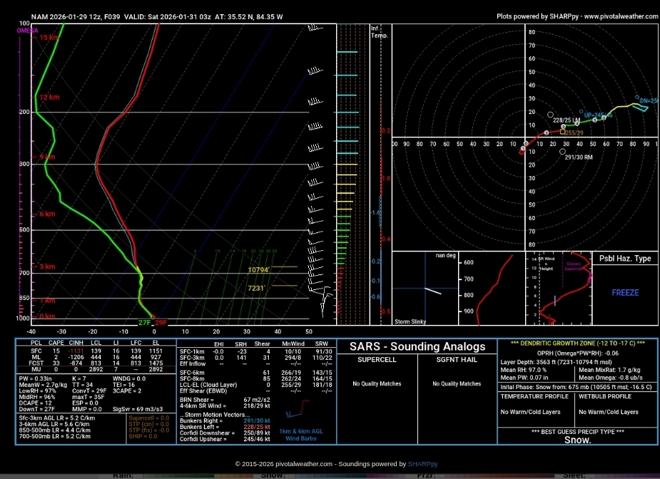
This is a sounding from south of 40 on the low res NAM...it shows the DGZ fully saturated. But for some reason the lift disappears only in the DGZ (mountains alone would create some lift.) So to me there is an error either in the Sharpy or algorithm. Problem is that model is ingested into the NBM = faulty NBM. Since it seems most offices now solely rely on the NBM...


.thumb.jpg.9707d4addca3d84715ae3d888c5c10d6.jpg)
