All Activity
- Past hour
-
First time since 2011 that we're going to get widespread 100s. Even in 2012 and last year, when there were 100s in the region, not everybody hit, and there was a chance it would just miss. But today and tomorrow look like no doubters for almost all of the region, like 7/22 and 7/23/2011.
-
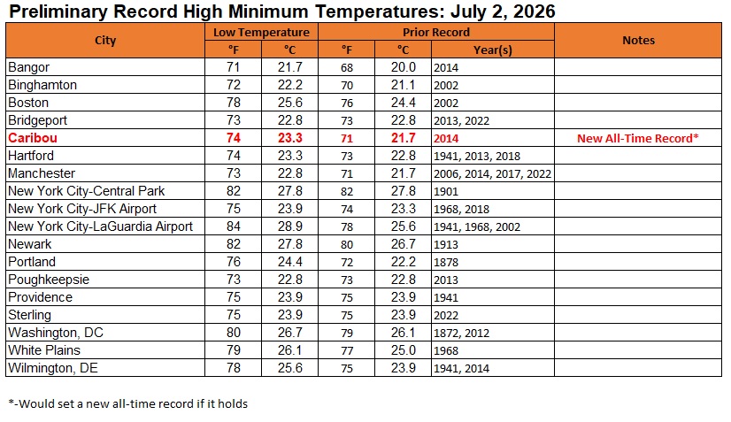
Select record high minimum temperatures (if they hold up through 1 am EDT):
-
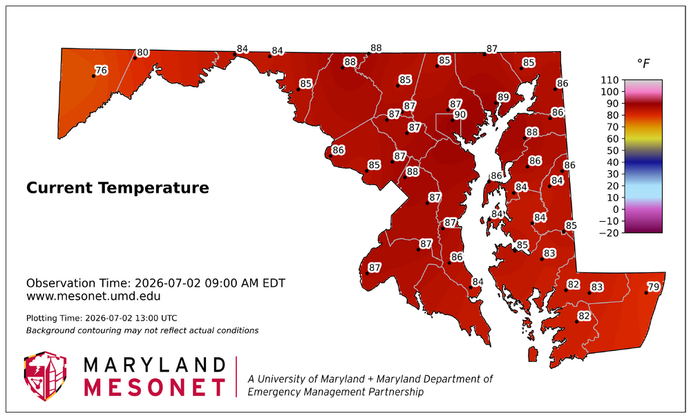
89/76/100 outside of Laurel MD. Today and tomorrow gonna be a special one
-
Do you know if there's a similar map for VA? Thank you!
-
87/78 as of 9 AM
-
Yeah, Brownsville is already 95° at 9am. Brownsville Temp: 95°F 3h Precip: 0.00″
-
In Carteret, weather station has us at 91° as of 9 AM.
-
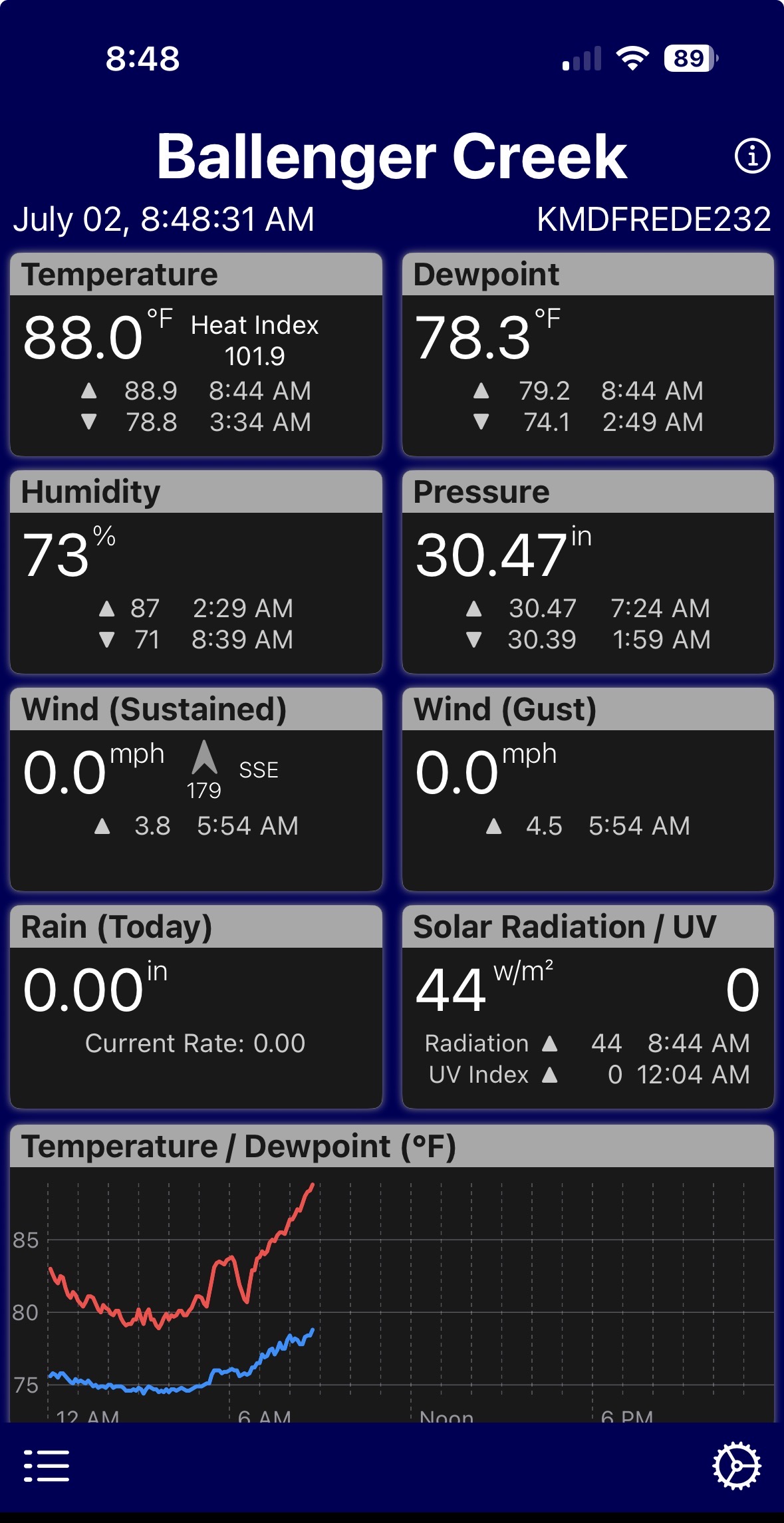
9am temps. DCA: 88 IAD: 87 BWI: 89 88.3 at home
-
 I always thought 90@9 was too aggressive. MHT did 19 after 9 yesterday. It probably works better for a place that stays very mixed overnight like BOS or ORH.
 -
 A lot of evaporation going on too with the rain that moved through. When I went outside with the dog earlier it was like a sauna with the steam rising.
 -
From Mount Holly AFD this morning- DISCUSSION... KEY MESSAGE 1...Dangerous heat and humidity will build across the region through Saturday. All time record high temperatures could be challenged today and Friday with widespread triple digit temperatures. Strong mid-level ridging across the Mississippi Valley, Great Lakes, and Ohio Valleys is building eastward into the Northeast and Mid Atlantic and will persist into the holiday weekend. A west to southwest flow will shift more west to northwest by Friday. The ridge will finally start to break and retreat some starting Saturday into Sunday. High temperatures are forecast to range between 100 to 105 degrees in most areas today and Friday. The shift to a more west to northwest flow aloft will allow for better mixing out of dewpoints during the afternoon, and also a component of downsloping (adiabatic warming) from the Appalachians. This phenomenon should be a little stronger on Friday with low level flow being slightly stronger, but regardless dewpoint should still mix out a fair amount this afternoon. This setup will support temperatures climbing above 100 degrees across most non mountainous inland areas as dewpoints mix out into the mid to upper 60s during the afternoon hours. Resulting forecast heat indices are mostly in the 105-110 degree range, though localized values upwards of 115 degrees are possible if dewpoints stay closer to 70 degrees. This is indeed the type of synoptic pattern that could challenge all time record high temperatures in our region. Areas north of I-78 are forecast to experience the hottest air temperatures (upper 90s to near 100 degrees, even as high as 95 degrees at Mount Pocono) today. Further south, the hottest air temperatures (mainly in the 100-105 degree range, and in the upper 90s to near 100 degrees for the New Jersey Shore and Delaware Beaches) are forecast to occur on Friday.
-
76 for my low
-
92 per mesonet. 100 seems inevitable.
-
Records: Highs: EWR: 102 (1966) NYC: 100 (1966) LGA: 101 (1966) JFK: 101 (1966) Lows: EWR: 56 (2001) NYC: 56 (2001) LGA: 58 (2001) JFK: 56 (2001) Historical: 1833 - An unusually large New England tornado, one half to three quarters of a mile wide, went from Salem Pond to Norton Pond, VT, and then into Canada. It prostrated nearly everything in its path. (The Weather Channel) 1833: The following is from the "History and Description of New England" published in 1860: "On the 2nd of July, 1833, this town (Holland, Vermont) was visited by a violent tornado, which commenced on Salem Pond in Salem, and passed over this place in a northeasterly direction. It was from half to three-quarters of a mile wide and prostrated and scattered nearly all the trees, fences, and buildings in its course. It crossed the outlet of Norton Pond and passed into Canada, and its path could be traced through the forests nearly to Connecticut River." 1843 - An alligator reportedly fell from the sky onto Anson Street in Charleston, SC, during a thunderstorm. (David Ludlum) 1932: Boston, Massachusetts recorded its lowest pressure 29.21 inches of mercury for the month of July. (Ref. NOAA Boston Weather Events) 1944: Today began the longest dry spell in Las Vegas, NV history which lasted until October 10th, a total of 101 days. (Ref. Wilson Wx. History) 1965: A cool morning 50° at Sterling, 61° at DCA. A cool 51° minimum temperature equaled July record low on 15th in 1940 in Richmond, VA. (Ref. Richmond Weather Records - KRIC) 1972: Large hail and damaging winds accompanied severe thunderstorms across parts of central Oklahoma. Baseball-size hail fell in the Oklahoma City metropolitan area, and winds reached 75 to 100 mph. The wind took down power lines and damaged or destroyed at least 23 mobile homes. Winds gusted to 100 mph at Lindsay, and 80 mph at Norman. The wind in these areas mainly damaged trees and blew down power lines, but also damaged a few roofs. (Ref. Wilson Wx. History) 1980: Wichita Falls, TX broke their old record by 10 degrees as the temperature hit 114°. This was the 9th consecutive day of temperatures above 100°. (Ref. Wilson Wx. History) 1986: Amazingly, an F2 tornado at Jacksonville, NC that killed three people was the deadliest twister of the year as the United States experienced only 15 tornado deaths during the year. This was an all-time low since records began in 1916. (Ref. Wilson Wx. History) 1987 - Thunderstorms in Colorado produced hail as large as golf balls northwest of Kiowa, which accumulated to a depth of twelve inches. Hail two and a half inches in diameter was reported at Black Forest. Hail damaged 900 acres of crops south of the town of Wiggins. (The National Weather Summary) (Storm Data) 1988 - Twenty-six cities in the eastern U.S. reported record low temperatures for the date. The morning low of 47 degrees at Roanoke, VA, broke the July record set the previous day. (The National Weather Summary) 1989 - Thunderstorms produced severe weather in the south central U.S., with 158 reports of large hail and damaging winds through the day. Evening thunderstorms in northeastern Texas produced softball size hail which caused more than five million dollars damage at Allen, and wind gusts to 90 mph at Dallas, which injured eight persons and caused seven million dollars damage. Winnfield LA reported 29.52 inches of rain in six days, for a total of 62.50 inches for the first six months of the year. Midland, TX, reported an all-time record high of 112 degrees. (Storm Data) (The National Weather Summary) 1992: An usually cold air mass for the time of year was in place across northern New York and Vermont. Saranac Lake, NY dipped to 30°. An observer in West Charleston, VT dropped to 30° as well with widespread frost and a frozen garden hose. A total of six cooperative observer stations in Vermont reported freezing low temperatures with East Haven reporting the lowest with 29°. Burlington, VT set a record low with 40°. (Ref. Wilson Wx. History) 1994: A US Air jet crashed near Charlotte, NC during a thunderstorm. The cause of the crash was officially listed as wind shear. Major efforts to understand and avoid wind shear have resulted in a dramatic reduction in the number of air accidents involving this deadly phenomenon. (Ref. Wilson Wx. History) 2001: In Michigan, frost and freezing temperatures were observed in some locations with Grant dropping to 29 degrees. Muskegon reported their coldest July temperature on record with 39 degrees. Other daily record lows included: Lansing: 38, Muskegon: 39, Flint: 40, Youngstown, Ohio: 40, and Grand Rapids, Michigan: 43 degrees. 2003: Thunderstorm wind gusts to 75 mph at Bigfork, MN, blew off the top of a tree, which went through the windshield of a car and impaled the driver in his seat; he lived. At Basswood Lake, a storm gust toppled a tree onto a tent; 1 camper killed and 1 hurt. (Weather Guide Calendar with Phenomenal Weather Events 2011 Accord Pub. 2010, USA) 2004: It was about a half hour into the storm that my grandmother recalls hearing what she calls a "blood curtailing scream" coming from me. She looked over to see me lifted from about 6 inches off the ground and dropped back down again. At first she though I had just become scared and jumped as she could tell that the lightning had struck not to far away. Read the full story at the following Ref. (Ref. A Lightning Survivor) 2007: All-time record dew point depression set at las vegas today June 27, 2011 at 432 PM PDT today the dew point depression at Mccarran International Airport in Las Vegas reached 129 degrees. The dew point depression is defined as the difference between the air temperature and the dew point temperature. In the case of today the air temperature was 107 degrees at 432 PM and the dew point temperature was -22 degrees. This made for a relative humidity of 1 percent at the time. The previous all-time record dew point depression for Las Vegas was 120 degrees set on July 2, 2007. The above information is preliminary and is subject to a final review before being certified by the national climatic data center. (Ref. NWS - A New Record To Be Certified) 2019: Measurable rain fell at the Richmond International Airport for the first time in 13 days. The drought began on June 20th and ended on July 3, 2019. (Ref. NWS - The Richmond International Airport Records)
-
 There's some mid 80s dappled around but most sites are just 80..81 now... still not good enough for 90 by 90. Logan's 88 though. The interior ... the more I look at this, they were hobbled by a wet outflow overnight and will need to work extra hard over the next hour
 -
Is that Greenfield Vilage?
-
Its a brutal start esp urban areas. It feels how yday afternoon did already.
-
90 / 76 blazin heat the next 66 hours. Heat peaking today - Saturday. Isolated storms Sat night, but still think most of the 4th is dry for bbq, beach, pool and fireworks but some showers/storms will pop. Sunday the caveat day with clouds keeping it below 90 or more breaks extending the heatwave to day 7-6 or 5. Mon/Tue look wet with front nearby and could push rain >1-2 inches in places. As is the usual case with major heat spikes and >594 Dm rudges, trough into the northeast 7/7 - 7/14 near normal and perhaps a straggler 90 but otherwise close to mid - upper 80s max. Ridge out west balloons into the plains and pieces of heat expands east 7/15 and beyond.
-
That is a crazy view of that fire. It is going to be a long summer out there.
-
Yeah I was working on Biltmore avenue this week. The truck thermometer read exactly 100 degrees yesterday. Freaking amazing working conditions.
-
Heatwave here: June 30 64 90 July 1 68 91 0.53" This morning's low was 74. Up to 85 shortly before 9am. Point and click warmer again with Friday at 101⁰
-
87.3 here at 8 53 am heat index at 96!!! Where I work( welding shop) just absorbs heat. Inside the shop it 114!!! The sun just bakes when it shines on the steel roof.
-
2012 had record May into June early melt ponding with the strong AD and AO blocking continuing through July. Then came the record early August storm leading to the steepest sea ice decline ever during the first half of August. No season since then has been able to put together those three factors. 2020 came the closest with impressive early melt ponding and the strongest AD and AO blocking since 2012. But the lack of a major storm in August and relaxing blocking as the month progressed allowed 2020 to finish just behind 2012. This season so far with lower pressures and colder temperatures from the late spring into early summer over the CAB is the opposite of 2020. So my guess is that as we head into early August 2012 will remain the leader. The 2007-2012 era was unique in that it featured consistent AD and AO blocking with plenty of May and June melt ponding. This quickly reversed in 2013 and continues to this day. The one thing we can say is that the historic Arctic sea ice thickness decline due to the loss from 2007-2012 of older ice has not reversed even with the more favorable summer conditions for retention since 2013. This has resulted in most of the seasons finishing in the 4.0 to 4.9 million sq km range. The finishes in the 6s and 7s haven’t been seen since the early 2000s. 2012 and 2020 were the only seasons to finish below 4million sq km.
-
That would be correct. And my station is in shade.
-

Central PA Summer 2026 Discussion/Obs Thread
canderson replied to Voyager's topic in Upstate New York/Pennsylvania
81 was my low. It is already 88 at 8:45 am.