All Activity
- Past hour
-

January 25/26 Jimbo Back Surgery Storm
Maggie Valley Steve replied to Jimbo!'s topic in Southeastern States
Still garbage here as well. -

January 25/26 Jimbo Back Surgery Storm
NYweatherguy replied to Jimbo!'s topic in Southeastern States
Looks like it's game on for metro Atlanta. -

Possible Record Breaking Cold + Snow 1/25 - 1/26
eduggs replied to TriPol's topic in New York City Metro
I gotta admit, the GFS/AIGFS make me nervous. That ULL in the Southwest has to eject. AND it needs to be well timed with northern stream shortwaves dropping south through MT and the Dakotas. There are always failure modes. -
Comparing the GFS to all other models for this upcoming storm might be the worst gap I've ever seen. We really need to retire it and invest more into our modeling here ... Oof. Unless it wins a coup and is correct but doubt it.
-
I don't like waiting on a second system west of the Apps. Too many times I have seen that slide into the Carolinas during previous storms. Need a 0z Euro solution or AIFS look. Fortunately, the GFS is well...the 12z GFS. There is a reason it scores poorly. The 12z GEM is trending south. And as always...read Jeff's post above.
-

January 2026 regional war/obs/disco thread
CoastalWx replied to Baroclinic Zone's topic in New England
Days and days? -

Possible Record Breaking Cold + Snow 1/25 - 1/26
WeatherGeek2025 replied to TriPol's topic in New York City Metro

-
No, did not move up to this area until 2016. I have often wondered what the NJ coldest minimum temperature on record really is. I believe it is recorded as -34 in River Vale (Bergen County) back in 1904. Have to believe it would have been colder than that in the Sussex County valley locations. Also how accurate is the -34 reading? Who and exactly where was it recorded? Lived in Park Ridge, next to River Vale for 10 years from mid 70's to mid 80's. Saw some cold readings during that time but temperatures on the coldest morning were always notably colder out in NW NJ.
-

Central PA Winter 25/26 Discussion and Obs
pasnownut replied to MAG5035's topic in Upstate New York/Pennsylvania
CMC takes the look of the Euro. We'd sign....well I would. -
-
150 pops a new coastal just off shore
-

Pittsburgh/Western PA WINTER ‘25/‘26
Mailman replied to Burghblizz's topic in Upstate New York/Pennsylvania
Just a foot area-wide on the Canadian. -

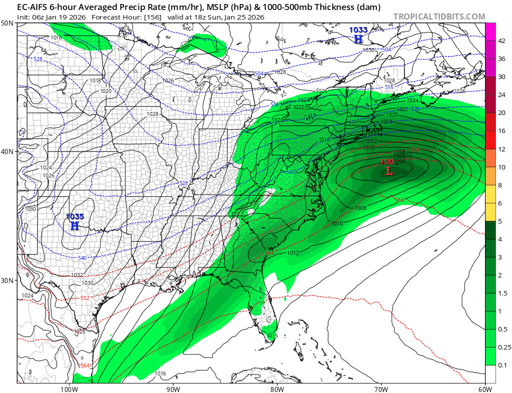
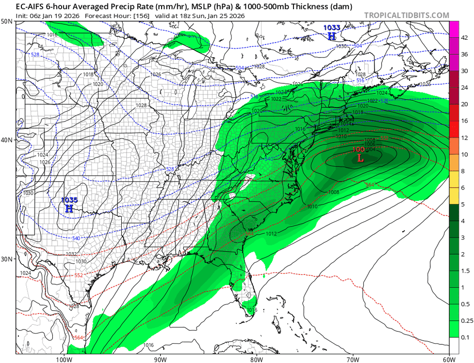
January 25-26 Winter Storm Potential
Violentweatherfan replied to Ralph Wiggum's topic in Philadelphia Region
I think the GFS is what it is because of how it’s handling the cold air. Therefore suppressed, how often do these super cold temps verify. Rarely, so I think the GFS will come north -

January 2026 regional war/obs/disco thread
SouthCoastMA replied to Baroclinic Zone's topic in New England
True, I was kinda worried to see that trend south..but I do trust the EUROAI more. -

Possible Record Breaking Cold + Snow 1/25 - 1/26
Jersey_Snowhole replied to TriPol's topic in New York City Metro
Yes I agree those temps will bring high ratios -
We need the first phase to be nearly perfect with next to no southern energy left behind for a HECS. For 6z this looked like a good consensus but now with 12z shifting the other way I agree its time to put those talks on hold till we see which way it goes at 18z and 0z.
-
January 2026 regional war/obs/disco thread
CoastalWx replied to Baroclinic Zone's topic in New England
Redevelops like the euro had with all that backside energy. -

January 2026 regional war/obs/disco thread
ORH_wxman replied to Baroclinic Zone's topic in New England
Euro suite slowed down overnight which definitely helped getting the storm north. I think that’s definitely what we want, a bit slower evolution that still gets plenty of northern stream involved…but that delay will allow the TPV to lift northeast and ease some of the confluence over us. -

Possible Record Breaking Cold + Snow 1/25 - 1/26
donsutherland1 replied to TriPol's topic in New York City Metro
It's significant, but notably lighter than the 0z solution. -
-
Gotcha, thanks!
-

January 2026 regional war/obs/disco thread
Spanks45 replied to Baroclinic Zone's topic in New England
CMC is kind of like PD 2003 storm, just lighter and a bit south.....a stronger southern system pushing a bit north would help a ton. Watching the radar loop from 2003, you can almost imagine that is what it would look like if the CMC run were to play out as is today at 12z -

January 25/26 Jimbo Back Surgery Storm
neverSnowsLCSC replied to Jimbo!'s topic in Southeastern States
Holy crap lol -
The Euro AI has been adjusting south too.
-
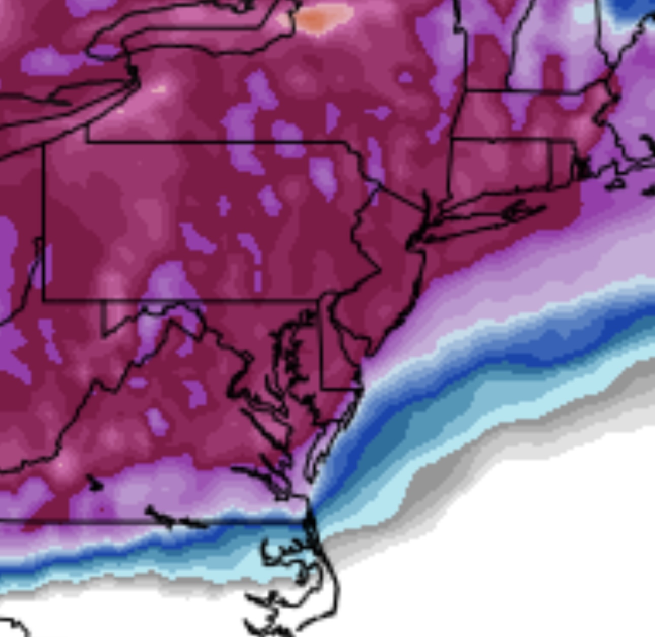
Looks like 13 on Kuchera.


(002).thumb.png.6e3d9d46bca5fe41aab7a74871dd8af8.png)