All Activity
- Past hour
-
Foggy morning here, maybe ~200m visibility off my balcony. it's been lingering for about 2 hours now, kinda surprising given the sun's been up
-

Septorcher 2026 Discussion - Endless Summer
Damage In Tolland replied to Damage In Tolland's topic in New England
Fire up the muggy meters! -
 Sildenafil 100mg price or Cheap Viagra 100mg Viagra online price http://celinaumc.org/System/Login.asp?id=45779&Referer=http://sildendirect.com viagra without prescription or https://mantiseye.com/community/ontcqtcvax Sildenafil Citrate Tablets 100mg [url=http://noexcuselist.com/li/?url=http://sildendirect.com]Viagra online price[/url] Sildenafil Citrate Tablets 100mg and [url=http://www.garmoniya.uglich.ru/user/tjogchmojo/]Cheap generic Viagra[/url] order viagra
 -
I have not had the AC in 3 weeks... Almost had to turn on the heat on this weekend.
-

Strong Nor'Easter/Hybrid Storm Late September 2026
jm1220 replied to Rjay's topic in New York City Metro
Was this a bad storm? Absolutely. But we’ve seen plenty of those since especially around 2010. March 2010 for example was devastating for many because of tree/power damage and we’ve had many more since. For coastal flooding in the back bays I think it briefly hit Major status which is what was expected. Upton was a little slow to catch on but eventually upgraded the coastal areas to high wind warnings and flooding was about what was expected. For days models had the 4-5” rains a chunk of us experienced and Upton had a similar total precip map out. The wet grounds aided in uprooting trees vs if we had dry conditions this summer. The beaches got pounded due to the storm lingering for days and yes it’s rare we get these so soon in September. But compared to other storms we’ve gotten in the last 15 years or so is it that historic-no. Disruptive yes. -
Yeah I thought today was supposed to be mostly sunny and in the mid 70s.
-

Septorcher 2026 Discussion - Endless Summer
BrianW replied to Damage In Tolland's topic in New England
Some dews as well.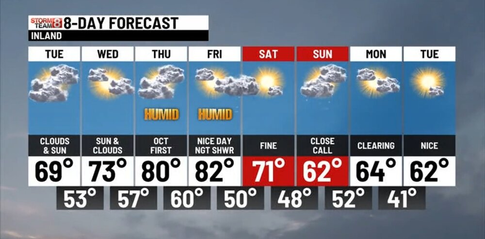
-
Yeah... we are a 13U and still have 8 core players from when we started at 9U.
-

Septorcher 2026 Discussion - Endless Summer
CT Valley Snowman replied to Damage In Tolland's topic in New England
Torch relative to the time of year on Thursday/Friday. 80-84 in this area. -
Ok storm passed 2 days ago, the clouds can go now.
-
Short-lived.
-

October Comes Early: Late September Multi-Hazard Hybrid Storm
HIPPYVALLEY replied to WxWatcher007's topic in New England
If it was winter, it would’ve cut 300mi west or have gone out to sea. -
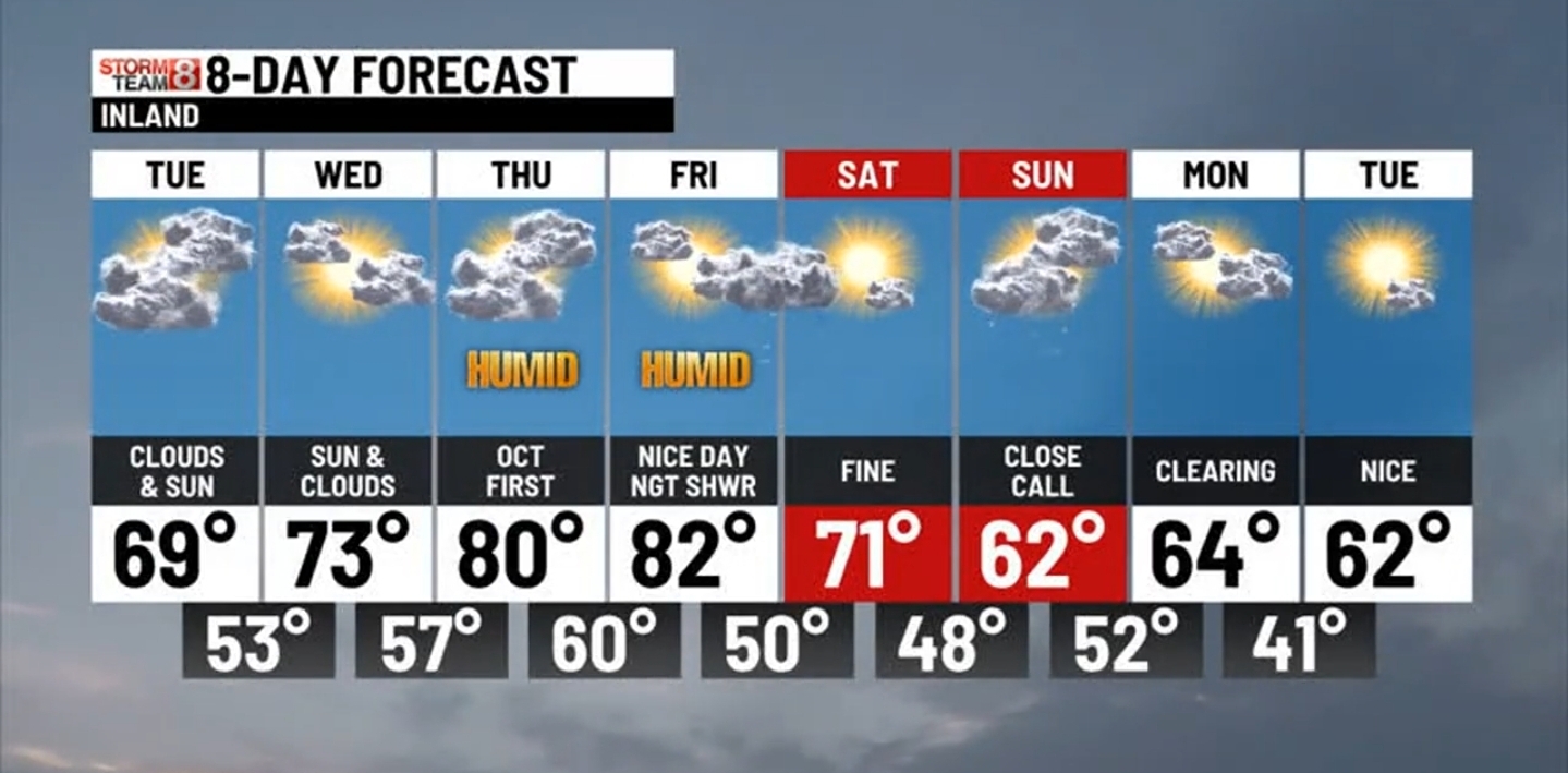
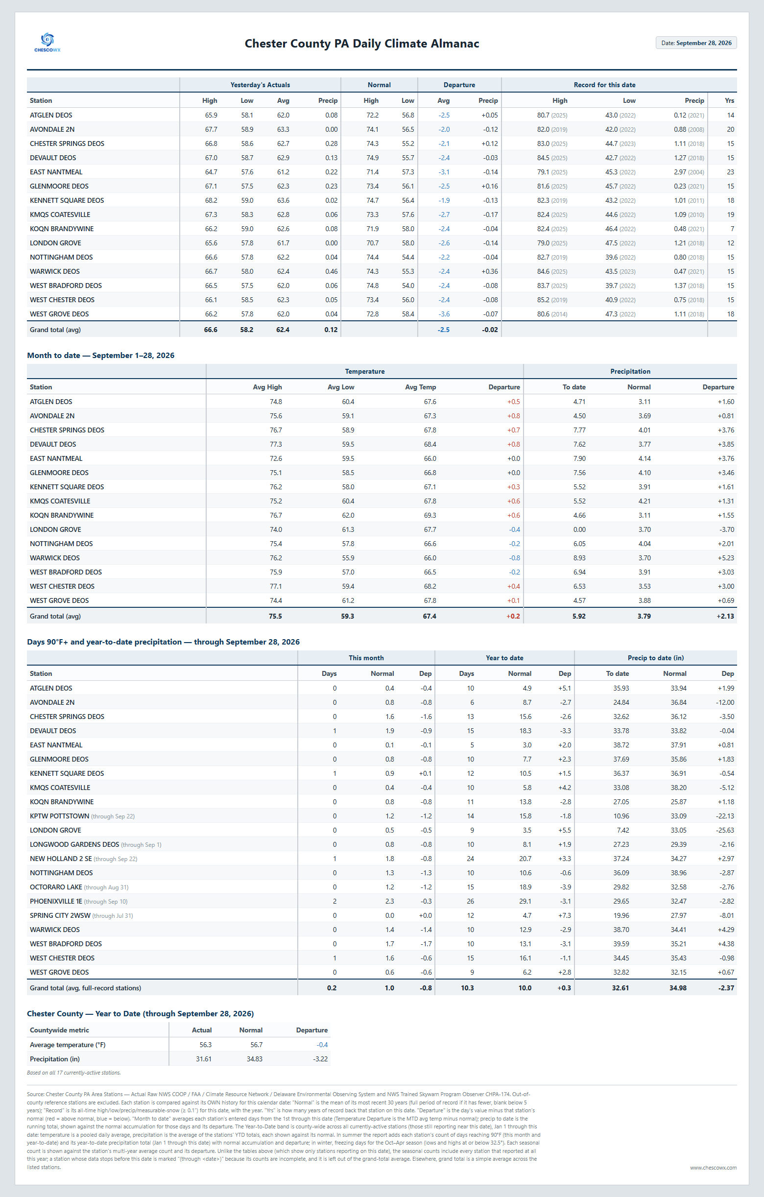
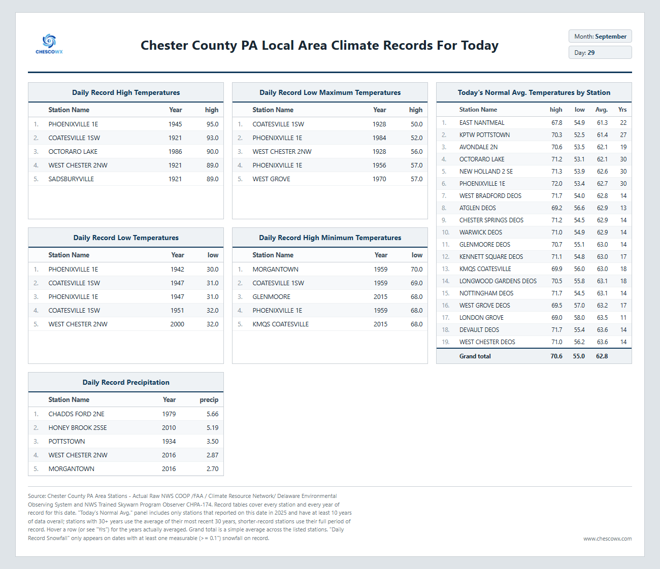
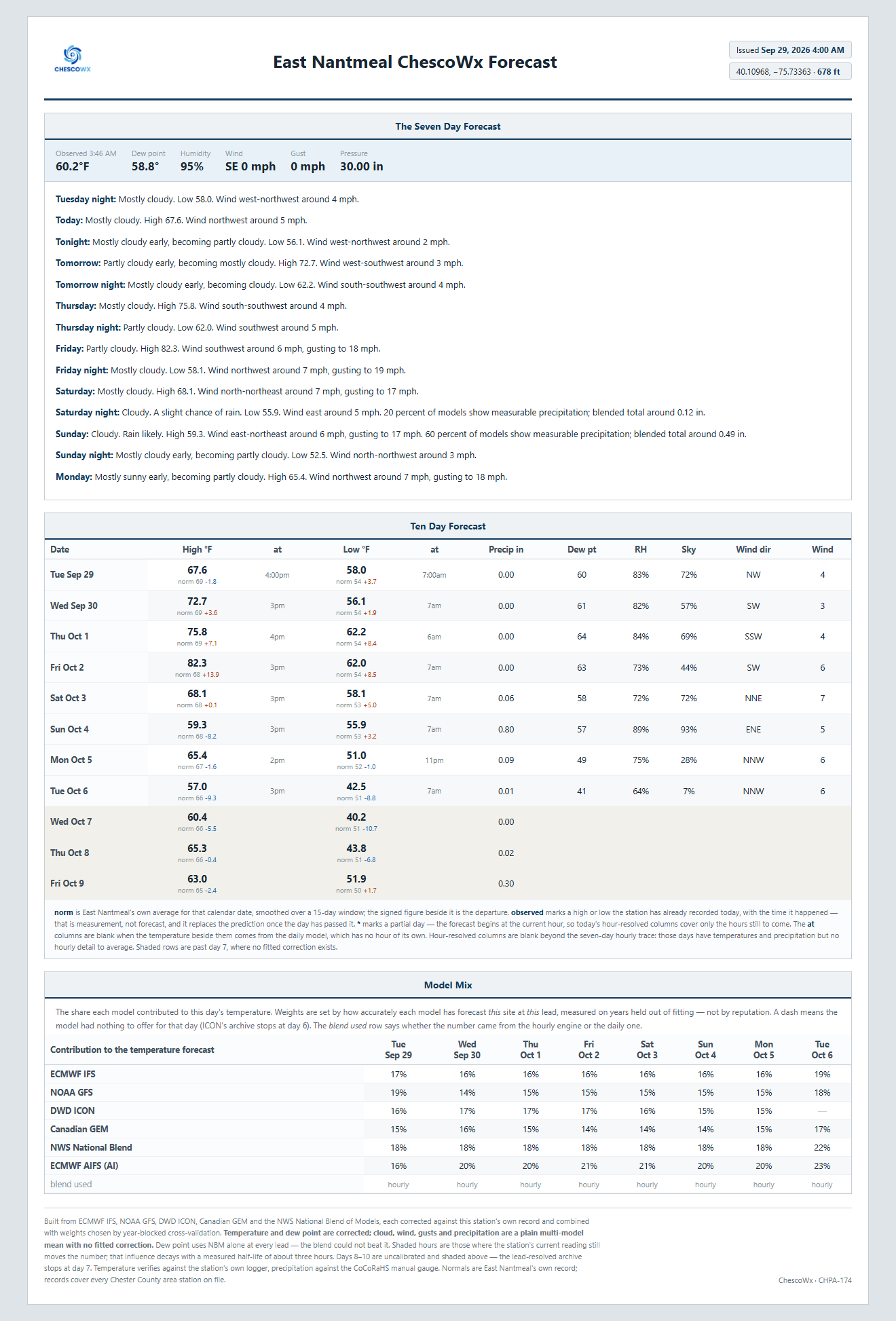
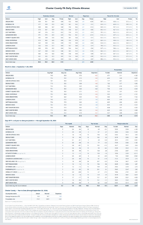
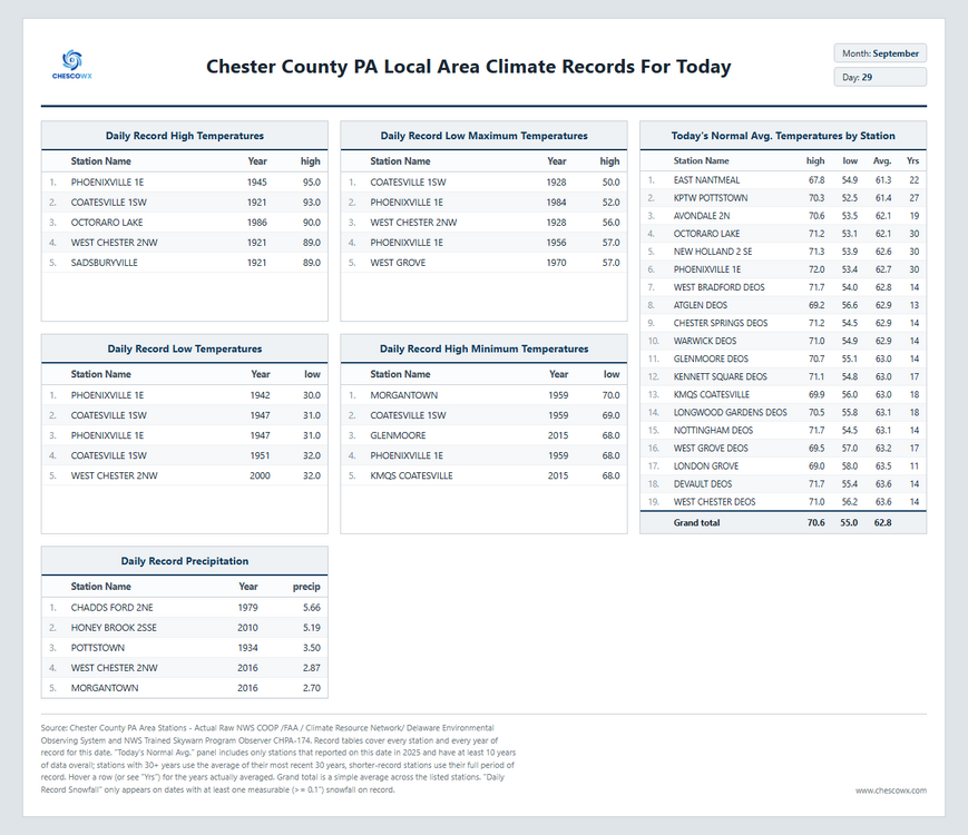
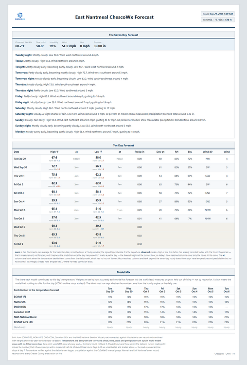
Happy Red October (a little early) for those that celebrate - GO PHILLIES! A nice stretch of warmer weather and sun through the remainder of the work week with temperatures possibly touching 80 degrees by Friday! We turn cooler again and wetter by the weekend.
-
(002).thumb.png.6e3d9d46bca5fe41aab7a74871dd8af8.png)
E PA/NJ/DE Autumn 2026 Obs/Discussion
ChescoWx replied to PhiEaglesfan712's topic in Philadelphia Region
Happy Red October (a little early) for those that celebrate - GO PHILLIES! A nice stretch of warmer weather and sun through the remainder of the work week with temperatures possibly touching 80 degrees by Friday! We turn cooler again and wetter by the weekend.
-

2026 Atlantic Hurricane Season
bigtenfan replied to Stormchaserchuck1's topic in Tropical Headquarters
As a S Florida resident I will take 8 storms like this every hurricane season. . -

Record Number of Extreme 10”+ Rainfall Months Since 2003
bluewave replied to bluewave's topic in New York City Metro
September 2026 was the 3rd consecutive month with parts of the area going over 10” of rain. Monthly Data for September 2026 for Upton NY NWS CWA Click column heading to sort ascending, click again to sort descending. CT NORTHFORD 0.8 SW CoCoRaHS 12.33 NY CENTEREACH 1.3 NE CoCoRaHS 10.70 NY SELDEN 1.6 ESE CoCoRaHS 10.67 CT DARIEN 2.4 NW CoCoRaHS 10.35 NY PORT JEFFERSON STATION 0.3 SSW CoCoRaHS 10.27 NY RIDGE 1.8 SE CoCoRaHS 10.18 -

2026 Atlantic Hurricane Season
vortex95 replied to Stormchaserchuck1's topic in Tropical Headquarters
The 1961-1990 avg is 10.5 NS per year. The current 30 yr avg 1991-2020 is 14.5. In last 10, is it 18. Lots of factors. 1) 1970-1994 was an unfavorable phase of the AMO for Atlantic TCs. Since 1995, it has been favorable. 2) Many more short-lived TS that used to be not declared or missed now get a name and as late as 1994, an off-season HU was not counted/included. 3) Prior to about 2000, NHC rarely declared/included ST storms. Since that time, they declare them routinely. Also, from 1989 to 1994, there was only one operational GOES satellite for the U.S. and it was positioned at 98W So this meant no real coverage for the eastern Atlantic. Meteosat and polar imagery were available for this part of the Atlantic, but it was not received in real-time for hurricane ops. Another thing that changed is when the next generation GOES became available by 1995, not only did we have two GOES satellite again for better coverage, but also image resolution and frequency from these new satellites increased. And when we got to the next "next" generation of GOES satellites, launched in 2017, the resolution of imagery increased again and the amount of data per hour went up by more than an order of magnitude. For instance, we get a full disk every 10 min now. Prior, it was only every 3 hr. A CONUS every 5 min, It was only every 30 min prior. And we went from 5 satellite channels to 16. This all greatly enhanced our capabilities to track and diagnose TCs in real-time. Purely from a standards/practices and technological POV, you can't compare on a level playing field prior decades to the last 3 or so when it comes to NS counts. And this applies for the entire globe. A true long-term avg, accounting for AMO cycles, needs to be 50-70 years of high quality data. -
Same here. We have seen so many modeled hits fizzle out.
-

September 2026 Medium/Long Range
Stormchaserchuck1 replied to JenkinsJinkies's topic in Mid Atlantic
I was 15, keeping a weather journal. Only year I ever did one. Picked one hell of a year for that huh! I was looking back and there was snow 4x in October, but it could have been flurries, or even just flakes -

Septorcher 2026 Discussion - Endless Summer
Great Snow 1717 replied to Damage In Tolland's topic in New England
Is the September torch happening today or tomorrow?? -
discount ed pills and cheap ed pills best online ed medication https://www.google.pt/url?sa=t&url=https://apexmenmeds.com ed med online or https://act2day.eu/profile/kxoipgypsu/ online erectile dysfunction medication [url=https://www.google.gg/url?sa=t&url=https://apexmenmeds.com]buy erectile dysfunction medication[/url] cheapest ed medication or [url=http://asresin.cn/home.php?mod=space&uid=1246443]best ed medication online[/url] buy ed meds
-
...Is it too early for me to come out of hibernation? How much snow will I see this year?
-
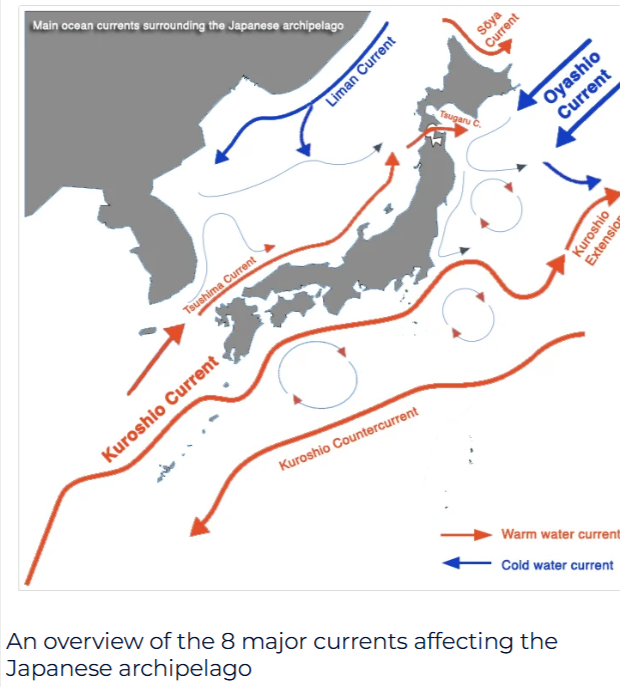
Starting to believe why we see it so warm in the West Pac is being caused by the Kuroshio Current. The Kuroshio is a feeding area for typhoons in which they can strengten SIG. as they track towards East Asia But the Kuroshio forms eddies and in which helps transport warm surface SSTS along it.Seen a couple papers i read in relationship to the ENSO when its a Central based NINO.The Kuroshio isnt as strong but also said more studies needed I believe its around the Kuroshio extension has the strongest currents in the world
-
I didn't think I was going crazy. BWI reported no snow in 10/02...not even a trace. For BWI, snow in November is a good (but not guaranteed since nothing in weather ever is) sign, but not October.
-

2026-2027 Record-breaking El Nino
40/70 Benchmark replied to Stormchaserchuck1's topic in Weather Forecasting and Discussion
I agree....they way I interpret that is some second half volatility. I don't see the season averaging -NAO. I think wave reflection is the path this year....like 1983. I don't think a reversal is in the cards. Guidance may try to flag one, and then back off.
.thumb.jpg.ad3a2e31d30aff035044689b311a0540.jpg)