All Activity
- Past hour
-

February 2026 OBS & Discussion
donsutherland1 replied to Stormlover74's topic in New York City Metro
The January 24-February 1 period has had a mean temperature of 16.9°. That is the coldest nine-day period since December 30, 2017-January 7, 2018 when the nine-day average temperature was 16.6°. Temperatures should begin to moderate tomorrow through Wednesday. One or two days could briefly rise to or above freezing. A few flurries are possible on Wednesday as a weak system brings a cold front across the region. Colder air should return on Thursday. A even stronger surge of Arctic air could arrive for the weekend, possibly accompanied by some snow flurries or snow showers. Overall, January 20th-February 3rd will likely be the coldest and perhaps snowiest two-week period this winter. The forecast WPO-/EPO-/AO-/PNA+ pattern is typically the coldest pattern in January and among the coldest during the first half of February. A persistently positive PNA will have above climatological risk of moderate or significant snowfalls. For perspective, the coldest two-week period this winter prior to January 20th was January 3-16, 2026 and January 4-17, 2026 with a mean temperature of 30.3°. The snowiest two-week period was December 14-27, 2025 when 7.2" of snow fell. Already, snowfall since January 20th has surpassed that figure. The ENSO Region 1+2 anomaly was -0.3°C and the Region 3.4 anomaly was -0.7°C for the week centered around January 14. For the past six weeks, the ENSO Region 1+2 anomaly has averaged -0.48°C and the ENSO Region 3.4 anomaly has averaged -0.68°C. La Niña conditions will likely continue into at least late winter. The SOI was +26.51 today. The preliminary Arctic Oscillation (AO) was -2.273 today. -

WxUSAF's weak ass frontal passage thing.
North Balti Zen replied to dailylurker's topic in Mid Atlantic
Aye, yes, that would be lovely -
Just enough to cover the dog poo piles, yellow patches, and all my bird food shells all over my yard lol. LFG!!!!!!!
-
Just like last winter. We’ve gotten a lot luckier with the few setups we’ve had but there are a lot of similarities.
-

Is we back? February discussion thread
Damage In Tolland replied to mahk_webstah's topic in New England
I remember you said the same thing leading up to NYE and we all ended up 2-5”. It’ll be a few inches of WAA snows Friday night . And then we’ll see if there’s squalls with front -
I don't know if winter will be over after this upcoming warm up, but it's unlikely to return to anything remotely like we've had this week with the cold and ice/snow being able to stick around. The Euro doesn't even go below freezing from the 9th to the 16th here. It's head faked warm ups a couple times this year already, but often when the Pacific breaks down in February and a big warm up hits, it lasts so long that we are in March before it relents.
-
 A severe cold spell you may not know about happened in Feb 1855. Caswell's weather diary from Providence RI states that on 6th and 7th, mins were -14F and -15F with max barely above zero. Then on 8th-9th 12.5" of snow fell at his location (within walking distance of Brown University where he was a professor). At that same time, Toronto had lows of -25F (on 5th and 6th) and daytime highs below zero (-6F on 6th). Caswell's diary runs from late 1831 to early 1860 with very few interruptions. The winter weather from 1854 to 1857 was exceptionally cold and snowy, an even colder version of 2013-16 for snowstorms of note. I don't know of any other N American data from 1855, sure there would be some though. Feb 1855 was also very cold in Britain, their third coldest February of 367 years of record (mean -1.7 C) ... only 1895 and 1947 were colder. The coldest part of the month in Britain happened mid-month to 20th.
 -
No Ruth Chris's for you.
-
and it is going against the CPC outlook of well below normal temps on the 9th and these models are saying this at day 9 -AI models can't be trusted in the longer range yet
-
i'd sign for this right now

-
I've waited to long for a stretch like this with deep snow cover and sustained cold so I'm still enjoying it. Give me another month to six weeks of this and I might be ready to cry uncle.
-
My last time over 20 was January 23. A couple of 19s in there so close.
-
Yea that would really suck and be a slap in the face lol
-
Don’t want to be in the bull’s-eye this far from that monster storm. It’ll be in the foothills by Tuesday night. What might’ve been .
-
The AI models have been pretty insistent that when precipitation finally returns around day 9, it's rain. I don't buy it yet because guidance has been too quick with warmups this winter. But there sure has been a lot of wasted cold this season.
-
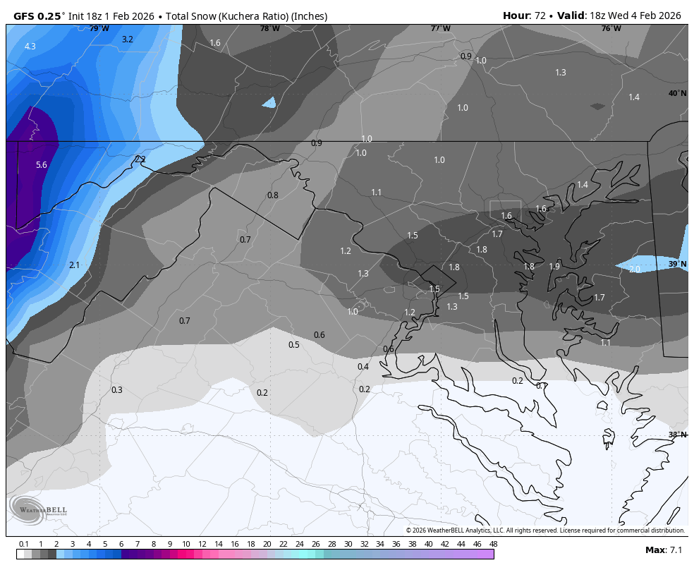
18Z GFS focuses the heaviest precip east of 81, between the beltways and east to the shore. Max of 2" right near DC.
-
Thank you for spending time with us. Tell your dad we thank him for his service!
-

February 2026 Medium/ Long Range Discussion: Buckle Up!
Scarlet Pimpernel replied to Weather Will's topic in Mid Atlantic
Meh...I'd rather see this than nonstop Pac Puke the entire month. At least could give us some element of decent chances. I wouldn't take an ensemble QPF amount at face value. Could it end up just being cold/dry following cold fronts from cutters? Sure. But the ensembles are smoothed, and we could also end up with a nicely timed wave with cold air around and get a good event. You wouldn't have a snowball's chance in hell (literally) of even that with a Pac Puke look. ETA: Apologies if that came off a bit confrontational or like finger-pointing at you. Just that the "mood" in here really gets annoying at times, with some people damn near writing off an entire month, etc., or thinking that if we don't get a "big" event (HECS-like) then it's all crap and a waste. I suspect that if we had gotten some decent or better snow from the thing this weekend, the mood in here would be a LOT better and more positive, and people would be looking forward to whatever we might be able to get in February, with the ensembles showing exactly what they do now. -
Fropa on the gfs still later in the week.
-

Pittsburgh/Western PA WINTER ‘25/‘26
EVLINC64 replied to Burghblizz's topic in Upstate New York/Pennsylvania
BAM Weather @bam_weather · 32m We are monitoring a strong clipper system to push through the eastern Ohio Valley to end the week. We will need to watch for eastward trends with this one, however accumulating snow looks likely!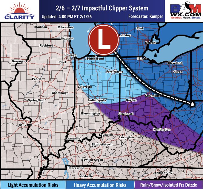
-
Today turned out nice with a high of 22.
-
 Goose egg here this morning. 24 for a high. There are power outages in Florida. Fortunately my parents have not lost it but many neighbors have. I asked why and they said power grid is "stressed".
 -

February 2026 Medium/ Long Range Discussion: Buckle Up!
Climate175 replied to Weather Will's topic in Mid Atlantic
That March 2014 St. Patrick’s Day snowstorm was a good one. Not common, but when it happened, quite a sight. -
Yeah it's up to 0.05" now in a few spots. But there has been no improvement in the height field in Ontario for several days. The RRFS dropped off at 18z. I was hoping this could trend into a 2-3" plowable event but it's settling into a C-1". And there's not much behind it. Super-suppressive northwest flow.
-

February 2026 Medium/ Long Range Discussion: Buckle Up!
Kmlwx replied to Weather Will's topic in Mid Atlantic
People have mentioned it before - but it's pretty clear to me that a lot of folks just use analogs totally wrong. I think the red taggers and the veteran snow trackers (psuhoffman and others) use them *correctly* Too many people see an analog date for big snow and assume big snow is "likely" and on the flip side - somebody will see a Boxing Day analog and get spooked. We should use analogs for large scale patterns NOT end results. It should go without saying that an analog is never going to be a 1:1 match down to every last detail. And in an atmosphere where one tiny change can have a big impact...even a 99% analog could go a completely different way in the end. Long way of saying yes - if I see Jan 2026 in the future analogs in future years - I will absolutely roll the dice with that.