All Activity
- Past hour
-
I read Jerimoth was 812. Either way it's a beautiful area sland I'd like to hike it some day.
-
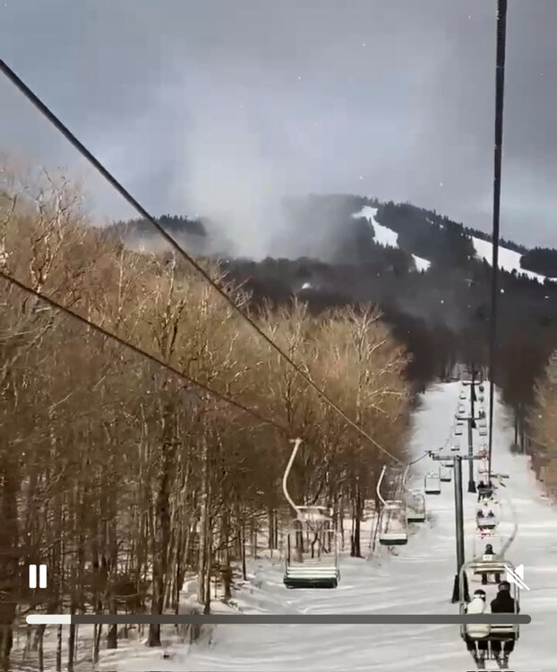
Had one day this winter with multiple large ones at Stowe. Biggest I can ever remember. Wish I could post the video, but too big size. Here’s a screen grab… much easier to see the definition in the video but that’s like a 1,000ft tall vortex.
-
Thank you, that was very informative...and also incredibly depressing. Implies, as I feared, some of the pacific issues we are having are more than just "its cyclical and we will break out of it". Don't get me wrong there are moving parts here and some of it is cyclical, we most definitely are in a -PDO cycle which is making some of it worse...but the theory here seems to be a la nina base state in the north pacific is the result of longer term changes related to the elephant. I've heard it before, makes sense...and is depressing. I have some questions regarding arctic amplification and any possible benefits. I think it's possible that when things go good...they could go VERY good...hence years like 1996, 2003, 2010, 2014. But there is a statute of limitations to how far that effect can last in a warming base state. For example, we are seeing mid level ridges linking up with high latitude ridges more and more...at some point that will simply be the normal every time and the benefit of high latitude ridging will be negated once troughs are no longer forced to cut under and everything simply amplifies into huge full latitude ridges and troughs. That isn't good even when we get under the troughs since a full latitude trough is typically just cold and dry and trasient. That's why i scream when someone breaks out a 1993 analog from 15 days out because the pattern that produced 1993 superstorm can do that...but 99.9% of the time that kind of full latitude trough/ridge configuration is simply a cold front and a few days of cold dry. Sure we could see more super massive storms but most of the time we will just see more warm/wet cold dry winters....heavy on the warm...is my guess. Also... does arcic warming really help if the whole base state is warmer? It's not really the warmth in the arctic that helps us its the flow created by a ridge there and how it compresses the mid latitude flow under it. If it's simply warmer up top does that do the same thing to the same extent? EHH? I don't know I am asking. Just spit balling what some of the implications of what I read would be for us. I see some ways in which it could help...could...but I see a LOT of ways in which it is already tangibly hurting us so...not thrilling lol
-

Presidents' day Snow potential
Freezing Drizzle replied to WeatherGeek2025's topic in New York City Metro
In this huge system, look where it's snowing. Lucky us. lol Raining out in Williamsport and State College, PA.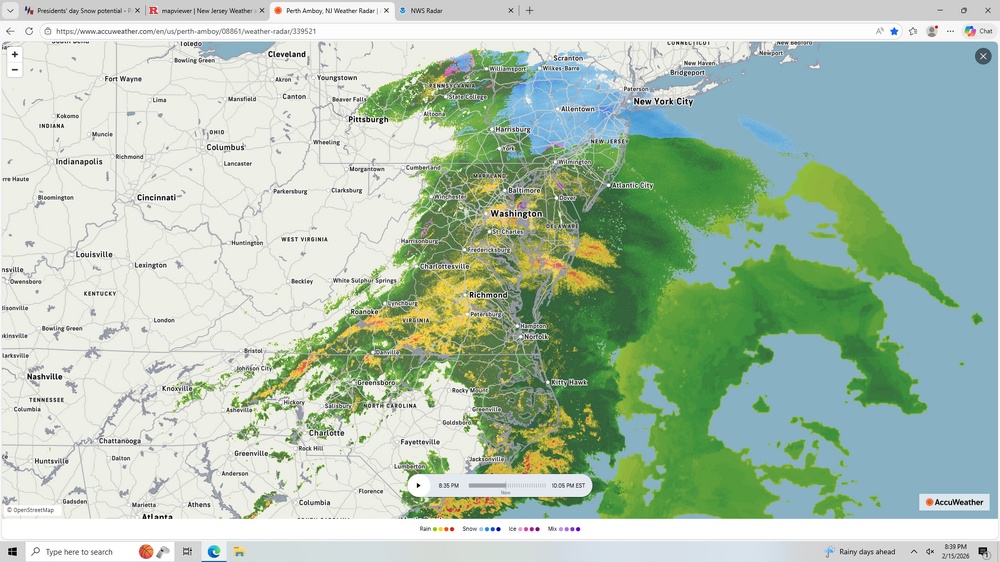
-
More mood flakes for the winter. I’ll take it
-

Central PA Winter 25/26 Discussion and Obs
Voyager replied to MAG5035's topic in Upstate New York/Pennsylvania
Cars caved. Sidewalks caving Street? Not yet, but it's snowing big fatties right now, so it's just a matter of time. -
Presidents' day Snow potential
Freezing Drizzle replied to WeatherGeek2025's topic in New York City Metro
Light snowfall here too. 36 F. Very still. -
JERIMONTH 731 is a half mile west same rd 101
-

Early Monday morning 2/16 last minute event OBS/Discussion
KamuSnow replied to The Iceman's topic in Philadelphia Region
There appears to be some snow mixing in with the rain here in Glen Miĺls Pa. That's with high intensity snow lamp and pattern recognition turned on. Currently 37F -
Preview: he can’t
-

Mid-Long Range Discussion 2026
WinstonSalemArlington replied to BooneWX's topic in Southeastern States
Winter’s Revenge next week -
I think we might have another storm.
-

Early Monday morning 2/16 last minute event OBS/Discussion
Chief83 replied to The Iceman's topic in Philadelphia Region
Worcester. PA. 33.6 Non paved surfaces covering. Light snow. Had started as light drizzle. -

Winter 2025-2026 Offers Return to Normalcy
40/70 Benchmark replied to 40/70 Benchmark's topic in New England
More Active Week Ahead Return of Pacific Trough Regime Implies Mixed Events Mid January Redux Pattern Reprieve The Eastern Mass Weather winter outlook from early last November posited that the milder Pacific trough regime would become prevalent during times of pattern relaxation. The first interval of this pattern presented as forecast, during the middle third of the month of January Another pattern relaxation of this ilk is also slated to return this week, during the middle portion of February. However, the trade-off for the milder temperatures will be a more active weather pattern in terms of bouts of precipitation. Milder & More Active Pattern Ensues For Latter Half Of February The implication for southern New England is likely to be a serious of attenuating waves that will be accompanied by light-to-moderate mixed precipitation throughout the region. The first such system is likely overnight Wednesday into early Thursday. The primary threat for a light snowfall is north of the Massachusetts turnpike. Then a follow up system Friday night into Saturday, which may be more focused on Connecticut. The largest storm potential exists in association with a potential coastal development on Monday, February 23, however, the early indication is that this system is likely to pass predominately out to sea and pose a larger threat to the Canadien Maritimes. More updates throughout the week as needed, including the potential Tuesday issuance of a forecast for the Wednesday system. -
Is we back? February discussion thread
40/70 Benchmark replied to mahk_webstah's topic in New England
Looks like a milder, albeit more active pattern is on tap for the coming weak. Two weaker systems with mixed precipitation likely overnight Wednesday and Friday. The first focused north of the Mass pike for a light snowfall, and the second maybe a bit further south, but quite a ways out. Initial hedge is mainly out-to-sea for a larger storm potential in about a week. Will have a closer look at Wednesday on Tuesday if necessary. This will not be a big deal. https://easternmassweather.blogspot.com/2026/02/more-active-week-ahead.html -

Presidents' day Snow potential
WeatherGeek2025 replied to WeatherGeek2025's topic in New York City Metro
Radar looks really good, this could end up a solid 2-4 -
Presidents' day Snow potential
WeatherGeek2025 replied to WeatherGeek2025's topic in New York City Metro
is there a lot more snow in Boston? -
(002).thumb.png.6e3d9d46bca5fe41aab7a74871dd8af8.png)
Early Monday morning 2/16 last minute event OBS/Discussion
ChescoWx replied to The Iceman's topic in Philadelphia Region
Moderate snow here in NW Chesco temp down to 32.5 all non paved surfaces covered -
Getting dat spring itch.
-

Early Monday morning 2/16 last minute event OBS/Discussion
Ralph Wiggum replied to The Iceman's topic in Philadelphia Region
Im up to 10 flakes spotted. Radar looks meh. 33F -
Ended with 1.19”. .
-

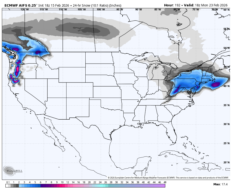
Late February/Early March 2026 Mid-Long Range
Blizzard of 93 replied to WxUSAF's topic in Mid Atlantic
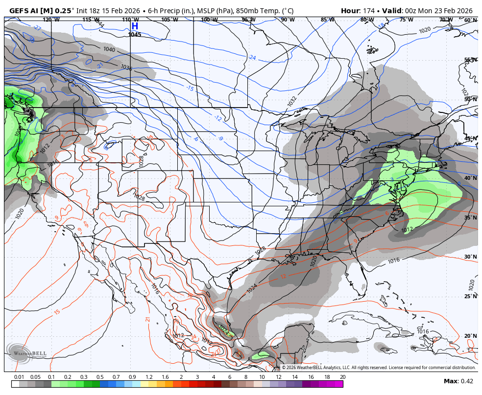
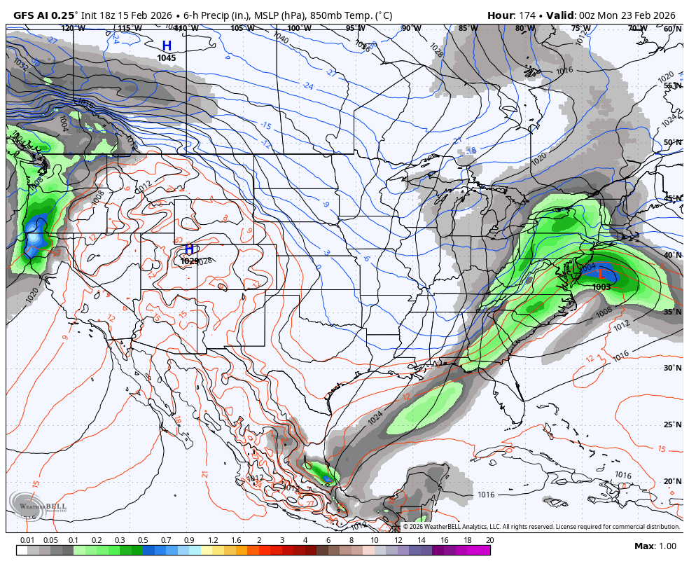
18z GFS AI & 18z GEFS AI also have the 23rd chance.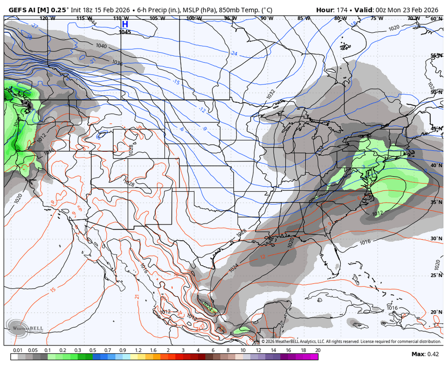

-
SREFs? ARPEGE?
-
Snow just started lightly with a temp of 35F (dewpoint 26F and a wet bulb temp of 31.9F), so hopefully we'll be down to at least 33F soon, which should allow easy accumulation on 32F snow/sleet. Paved surfaces will take longer and require higher rates of course.
-
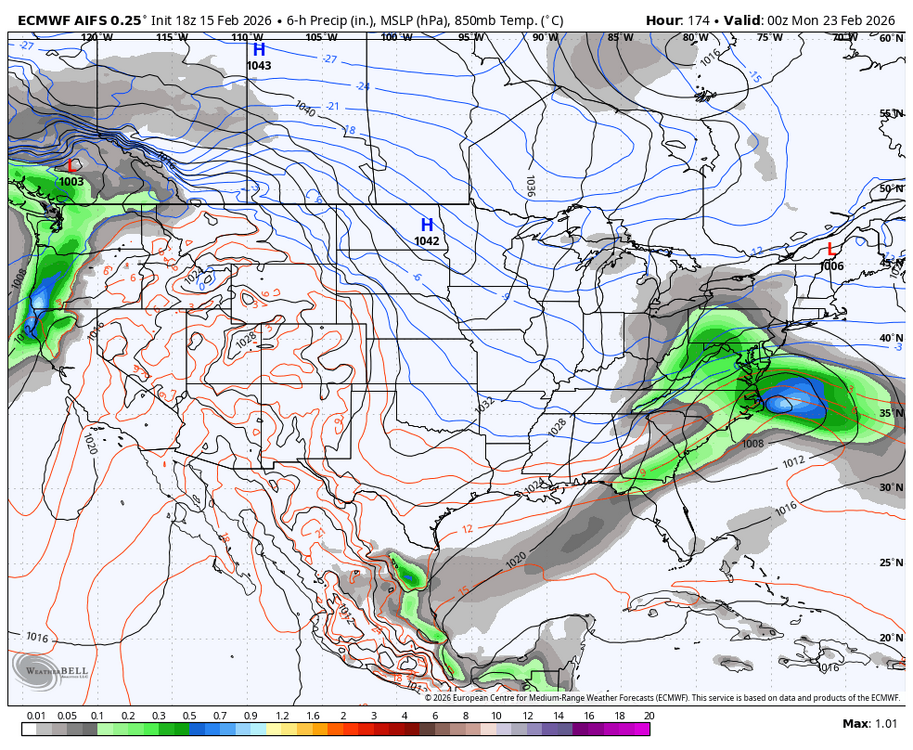
Late February/Early March 2026 Mid-Long Range
Blizzard of 93 replied to WxUSAF's topic in Mid Atlantic
18z Euro AI has the 23rd chance.