All Activity
- Past hour
-

E PA/NJ/DE Winter 2025-26 Obs/Discussion
Physicsteve replied to LVblizzard's topic in Philadelphia Region
Hope that works out thermals-wise, though I am suspicious of a widespread all-snow event unless we get dynamics going for us again. Snow to rain has been modeled with this more than once. -

Is we back? February discussion thread
RUNNAWAYICEBERG replied to mahk_webstah's topic in New England
Yea. Eff dews. I like warmth but not dew warmth. -
That’s been looking like 2-3/2-4 for a day or so now
-
Yes please!!!
-
Just for fun ... but if your a spring enthusiast lookin' for a dopa hit, check out the CFS for March 12th
-
Exactly and the recent icon is way north because it weakens Sundays wave.
-

Outta gas and Outta Time: Early March Winter Storm finale
87storms replied to Ji's topic in Mid Atlantic
After 4 months of a statistically cold winter, you’re ready for spring? Unacceptable. That next week system doesn’t look as wavy as I’d like, but nice to see a cutoff low of sorts out west. They still need precip. -
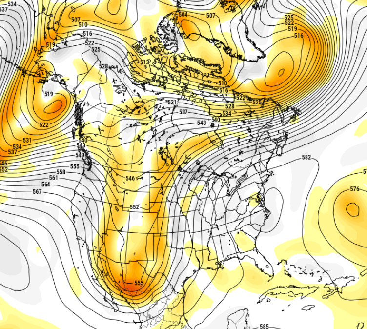
06z OP Euro
-

Outta gas and Outta Time: Early March Winter Storm finale
psuhoffman replied to Ji's topic in Mid Atlantic
Icon has been better this winter, from my observations. Not great, no model has been great, but its not been any further off than anything else and frankly has been more consistent than some of the other guidance for several events. -
Slept in a little this morning, and I wake up to 1"+ of snow. Still snowing, so will take a measure later, and report it. Wasn't expecting that much.
-
Outta gas and Outta Time: Early March Winter Storm finale
psuhoffman replied to Ji's topic in Mid Atlantic
Back in the fall several people made the correct point that this winter would be heavily northern stream dominant, and given the state of the northern stream lately (fast and chaotic) it would mean whatever snow threats we did end up getting would be unlikely to resolve at any significant leads. Several people referenced 2013-14 as an example, when we got numerous snow events but they were far from resolved until inside 24 hours! Some, like early Dec 2013, was a positive bust in the nowcast! There was a negative bust for all except the PA line people in early Feb also. Both cases the going forecast as the storm began was WAY off...one turned snowier and one not. But I've found it entertaining and sometimes frustrating to see all the "why are the models sucking arse" posts all winter when this was a known thing coming in, it was predicted over and over...and yet people still expected 100 hour forecasts to end up accurate, knowing that this pattern was not one models would resolve details on at any lead let along 100 hours plus. big picture he is totally right. But...sometimes late in the season this little boundary waves can be sneaky good given the increased baroclinicity. This also seems to be increasing in recent years...maybe elephant related? While it helps us less and less often, when we do get a flush hit from a weak little boundary wave they sometimes are way more than you would think just looking at the synoptics. That isn't something you would forecast from range though, its just something to root for as a "sometimes this can be sneaky good if we get lucky" thing. -

Outta gas and Outta Time: Early March Winter Storm finale
mitchnick replied to Ji's topic in Mid Atlantic
Similar to 6z EuroAI -
i need to get a big snowstorm for next week my snow potential map is going viral and i need to be right otherwise it won't look good for my weather page
-
The RGEM was headed that way too it seemed.
-
None really getting up into SNE but I think it still could. I do believe though Sunday needs to go away or be very flat. Its noticeable on many Op runs and individual ensembles that those which are amped or more intense Sunday as a whole are flat or nonexistent with the second event.
-

Central PA Winter 25/26 Discussion and Obs
Voyager replied to MAG5035's topic in Upstate New York/Pennsylvania
43 in the Tamaqua backyard at 10:30am. Even warmer here in Allentown. Hopefully we get a full sunny day today. That way, all of the old snowpack will be gone before anything next week materializes. -

Outta gas and Outta Time: Early March Winter Storm finale
Weather Will replied to Ji's topic in Mid Atlantic
WB 12Z ICON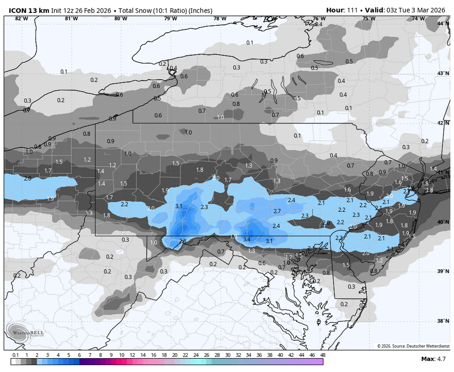

-
no kidding. 100% of possible so far down here. MET MOS 41. Noooormally I'd suggest at this time of year we add the perfunctory tick or two to the high, but with all this white shit underneath ... DPs are low so melt will be slow but the sun will breach that critical angle for maybe 1.5 hrs at zenith this time of year, and that becomes more of a direct melt assault for that time span. Probably a lot of dripping and some street gutter brooks at that time. I'm ready... I could use a 55/48 overnight rainer to really eat this shit down. We'll cross the flooded bridge if/when that happens.
-

E PA/NJ/DE Winter 2025-26 Obs/Discussion
MJO812 replied to LVblizzard's topic in Philadelphia Region
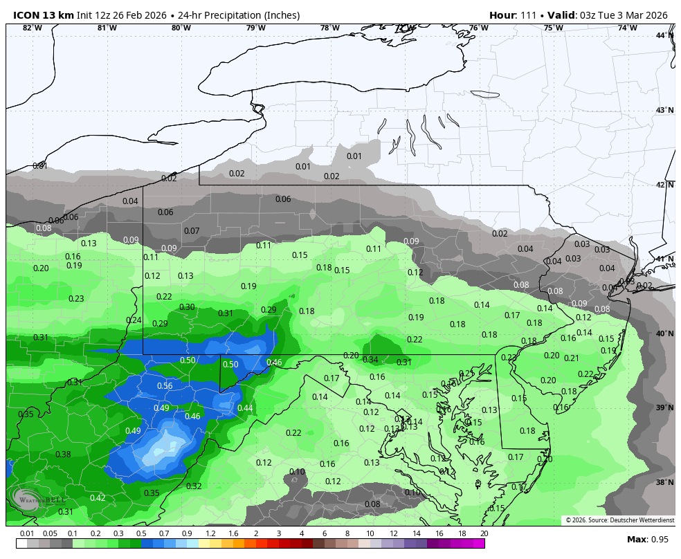
Huge north shift on icon due to the high being way further east..thumb.png.f8eb2406d6e93cb7cc1ce40b65534c58.png)
-
Icon further north for next week 6z vs 12z
.thumb.png.83dc30005eab487629516fc23fe6506a.png)
-

Outta gas and Outta Time: Early March Winter Storm finale
rjvanals replied to Ji's topic in Mid Atlantic
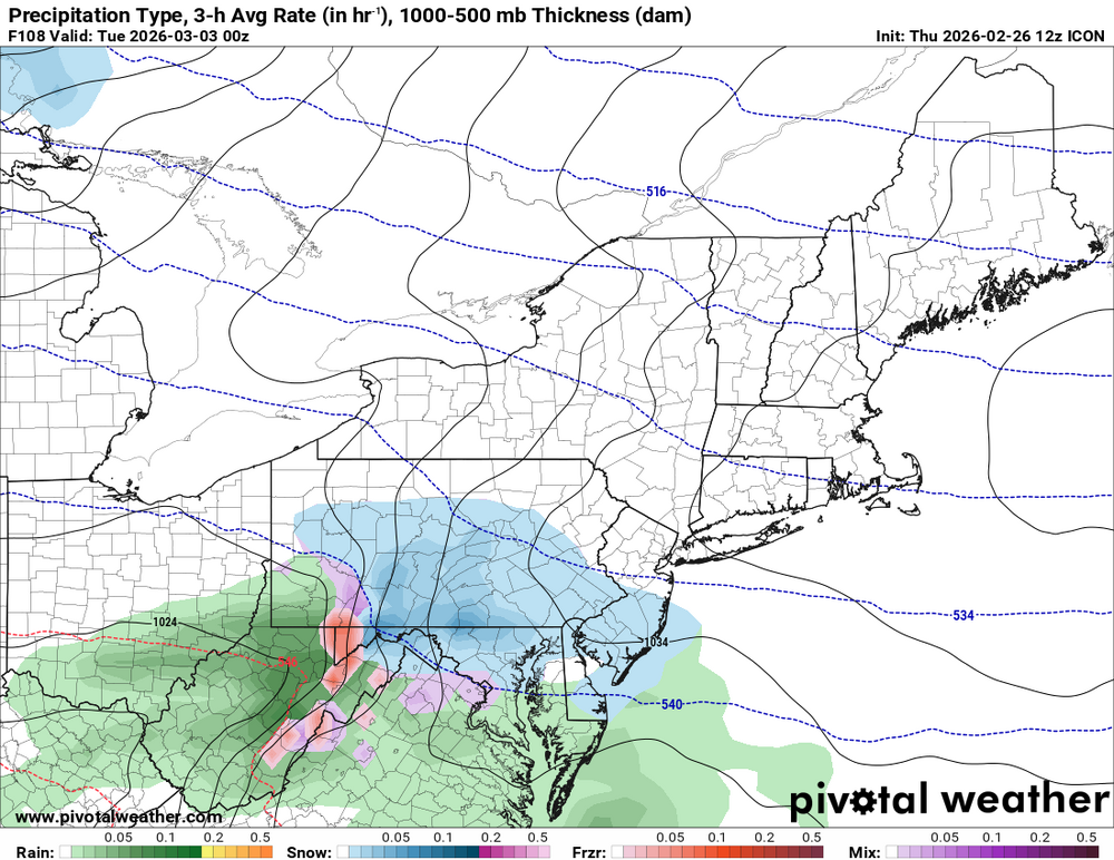
Icon brings some snow north of I-70 -

Outta gas and Outta Time: Early March Winter Storm finale
MillvilleWx replied to Ji's topic in Mid Atlantic
Took some time away from models after a crazy 7 day stretch at the winter desk. Just from a glance, I haven’t been too enthused. Still a shot at some snow, but max potential is probably 2-4”. Need something with more umph this time of year to really get anything appreciable. Judging by the ensembles after this one, I’m gearing up for spring mode. Baseball is on the horizon and I’m ready to tackle some outdoor walks, hiking, and meals outside. I’ll always welcome some snow though, so if it happens, I’ll accept. -
Also have to differentiate between short term and long term drought. Long term drought isn't a huge deal around here because we don't have the issues with limited supply the West has. It seems our short term drought is mostly gone after today in NC.
-
2014-2015 was followed by a record warm May (or at least close to it). One of the most remarkable pattern turnarounds in spring, right along with 2010.
-

Outta gas and Outta Time: Early March Winter Storm finale
wasnow215 replied to Ji's topic in Mid Atlantic
Do you agree that models are "overcooking" a storm and it won't be much for anyone?