All Activity
- Past hour
-
Wye Mills mesonet 1.7" Ridgely an inch so far
-

Central PA Summer 2026 Discussion/Obs Thread
Voyager replied to Voyager's topic in Upstate New York/Pennsylvania
I got .36" so far, but that was nothing but a few light to moderate showers. No storm whatsoever. -
I am right in it on the northern edge here. Hoping to salvage a half inch or so. Places just south are likely going to get 1-2"
-
Yes. Looks like a wet microburst.
-

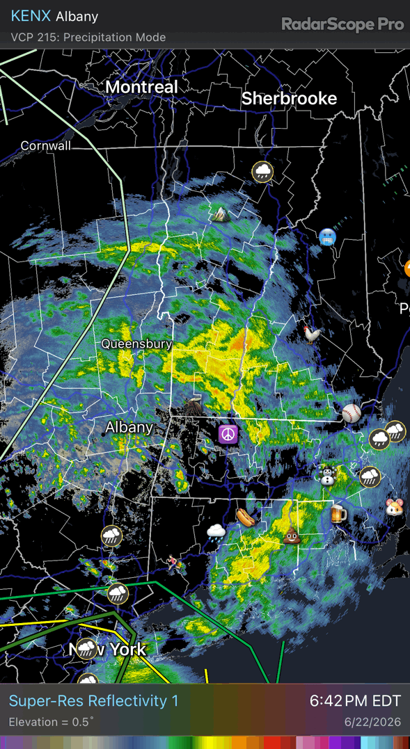
Wet late Monday 6/22 or another Fizzle?
nw baltimore wx replied to Weather Will's topic in Mid Atlantic
Rough cutoff line here. Just a trace..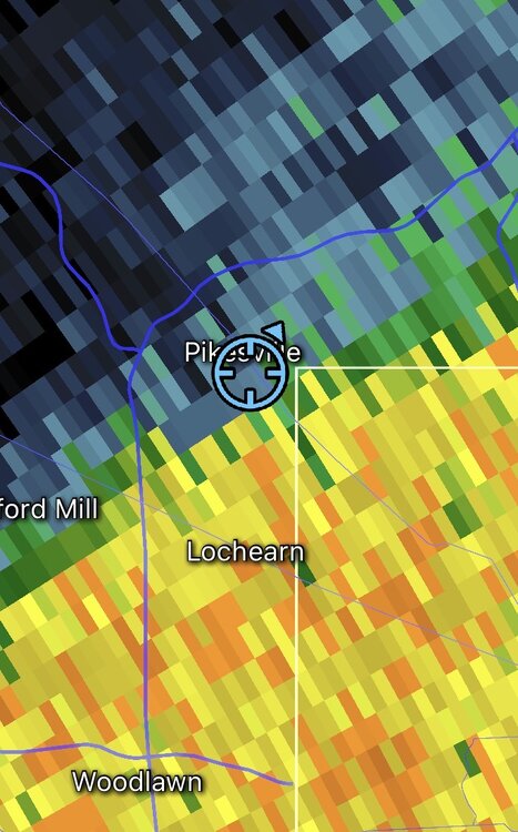
-
At Little River Tpk and Braddock Rd, a big 20 min gully washer, weak T&L, and surprising, no wind whatsoever.
-
Should go over 1” here. Looking good back to NY

-
Typical fail zone up this way.
-

2026 Mid-Atlantic Severe Storm General Discussion
WxWatcher007 replied to Kmlwx's topic in Mid Atlantic
- 861 replies
-
- 1
-

-
- severe
- thunderstorms
- (and 7 more)
-
News 12 reporting some 2” amounts in northern nassau can’t anyone confirm? Seems way overdone
-
More severe weather potential late June and early July https://x.com/TylerSebreezy/status/2069109423008542773 The next 2 weeks feature a good deal of potential severe weather opportunities. The NSSL machine-learning output here isn't the only thing supporting severe weather risks in late June and early July.
-
Looks like some hail near Ridgely. Already 0.42" there. 0.23" here.
-
Some videos popping up out of Burke look pretty gnarly. Maybe a microburst?
-
Big tornado warned area in Dorchester
-
huge supercells with strong rotations east of Fort Morgan
-
I think you are getting crushed dude. Probably an inch at least.
-
The worst is sinking a bit south but heavy rain looks like a good bet.
-

Junorch obs and discussion 2026
Damage In Tolland replied to Damage In Tolland's topic in New England
Well sure. We said a few more showers could move thru . But the main stuff is over -
You are gonna get nailed pretty good by the looks of it. Bowing segment with some hail per radar.
-
Nope. The ongoing stratiform rain over us is what I was calling "round 2", and the HRRR seems to have a very good handle on this. After this ends soon, I think we have to wait until tomorrow morning.
-
Booming thunder. Looks like Ridgely 3 miles to my SW will get hit pretty good. Be interesting to compare the Mesonet site there to my station lol. Looks like I should see at least some moderate rain.
-
Looks like you will get some.
-
Upton mentions a wave on the front tonight/tomorrow which will bring more rains especially east of NYC .WHAT HAS CHANGED... The chance for showers has been expanded Tuesday as a wave of low pressure develops along a departing cold front.
-
12.37” here
-

2026-2027 Super El Nino
michsnowfreak replied to Stormchaserchuck1's topic in Weather Forecasting and Discussion
One more thing on this...im not a big fan of Cc adjusting because of the relatively minor implications it would have, not to mention its full pf assumptions....but i do feel both 57-58 & 65-66 would be BETTER winters here today than they were at the time. 50s/60s winters as it was were very different from each other (50s much much milder) but both winters saw warm, wet decembers followed by cold/dry. While cold/dry certainly still happens, we tend to get more snow out of it nowadays. And im enjoying summer myself so far. Summer/Fall ahead of el ninos are usually very enjoyable.