All Activity
- Past hour
-
Sun out. Feels like Spring again with the sun strength/location, although still a chilly 34. Snow melting. Big difference between this little event happening now and a month ago.
-
DVN mentioned the B word. Will be on edge of snowfall gradient here. Shocker. Lol.
-
Really coming down here in suffolk! Deck covered and now starting to stick to grass.
-
There’s been no shortage of cold air this winter in the east. I’d be surprised if this is the last opp of the season.
-

Rain/Thunder and Anafrontal Snow
WeatherGeek2025 replied to WeatherGeek2025's topic in New York City Metro
moderate snow in the bronx right now -
Had a few snow/sleet grains but 39 and just cloudy now
-

80 Degrees to Ripping Snow: March 12th
Stormchaserchuck1 replied to SnowenOutThere's topic in Mid Atlantic
Some pictures from the snow -
.thumb.jpg.6a4895b2a43f87359e4e7d04a6fa0d14.jpg)
Central PA Spring 2026 Discussion/Obs Thread
Yardstickgozinya replied to Voyager's topic in Upstate New York/Pennsylvania
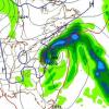
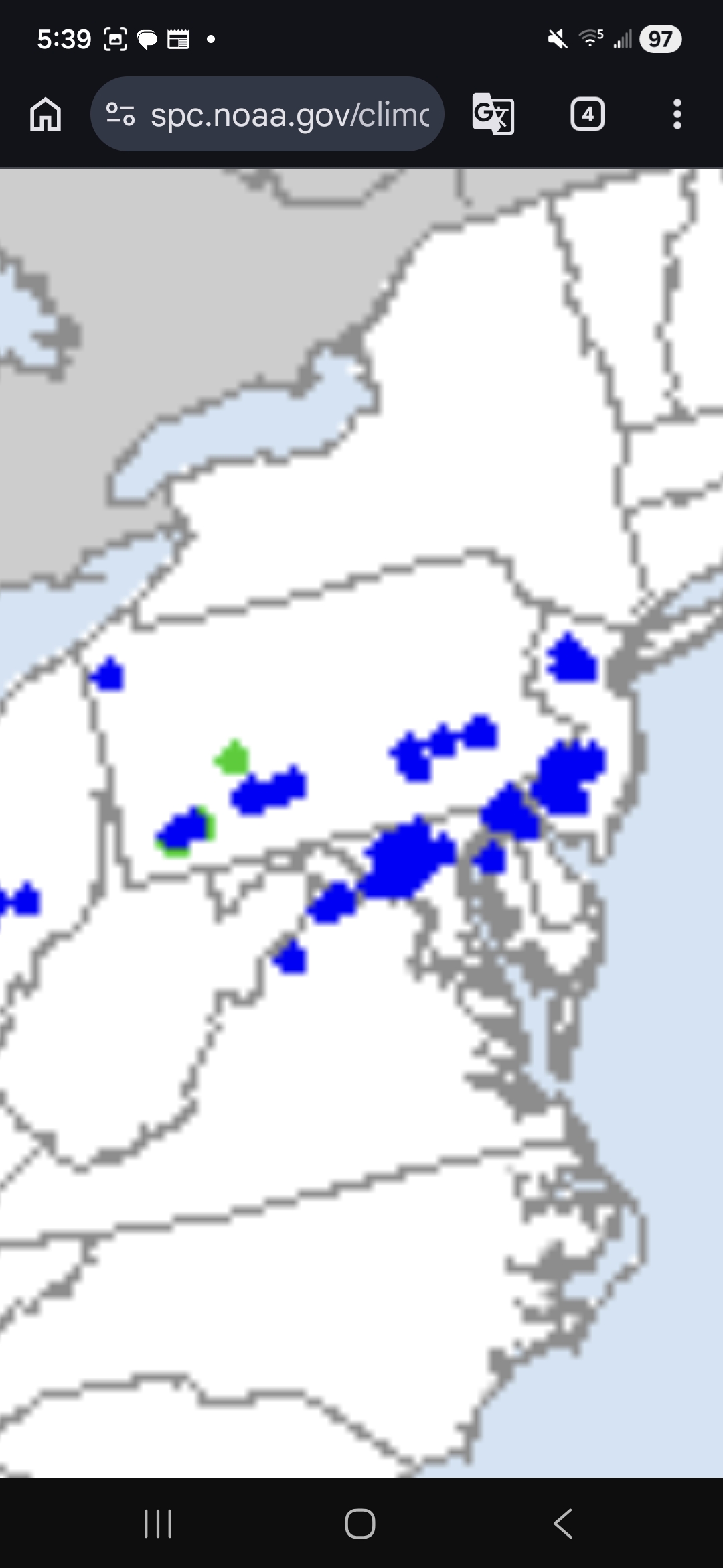
Not even a hail report with yesterday's supercell. That looked to be one of the most intense hail cores I've seen in these parts in a few years. I think the location of this storm during its peak played a big role in the lack of storm reports. It couldn't have taken a better path to absolutely affect nobody. I don't have the circle placed perfectly but it's very close. https://www.spc.noaa.gov/climo/reports/yesterday.html

-

Southern MD / Lower Eastern Shore weather discussion
SnowtoRain replied to PrinceFrederickWx's topic in Mid Atlantic
Same here, dropped down to 32.4 during the heaviest. -

E PA/NJ/DE Spring 2026 Obs/Discussion
Hurricane Agnes replied to PhiEaglesfan712's topic in Philadelphia Region
Back edge is moving through, the sky is brightening, and the sun is trying to come out. Ended up with 0.25" of snow, trace of sleet/ip, and 0.26" of rain/snow/ip melt in the bucket. Anything that had coated or dusted any surfaces, has melted. Currently overcast but clearing and 35, with dp 35. -
18z GFS casually with 6 feet of snow near Marquette. Ungodly with the lake enhancement to boot.
-
Coating on the grass/deck/cars, nice winter send off.
-
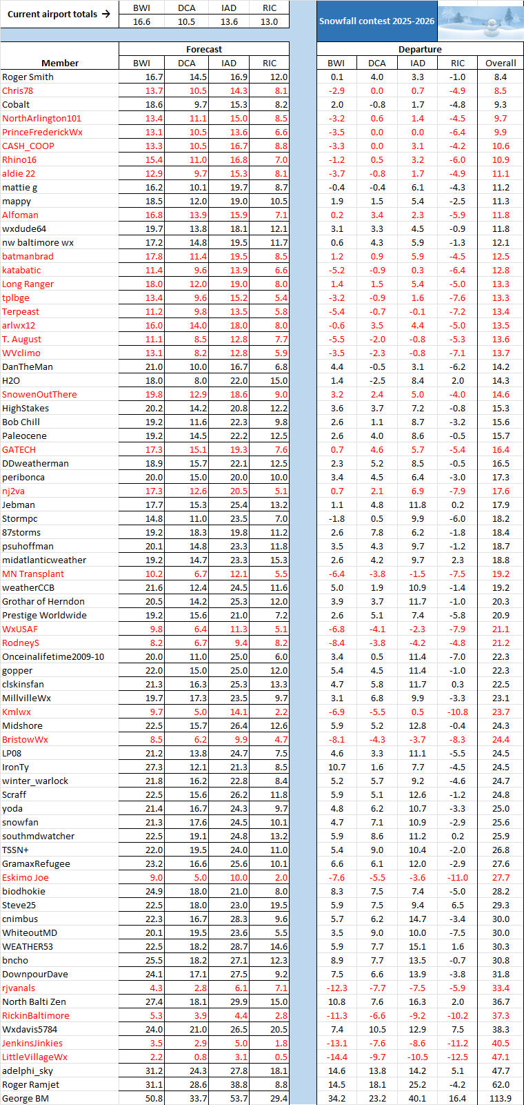
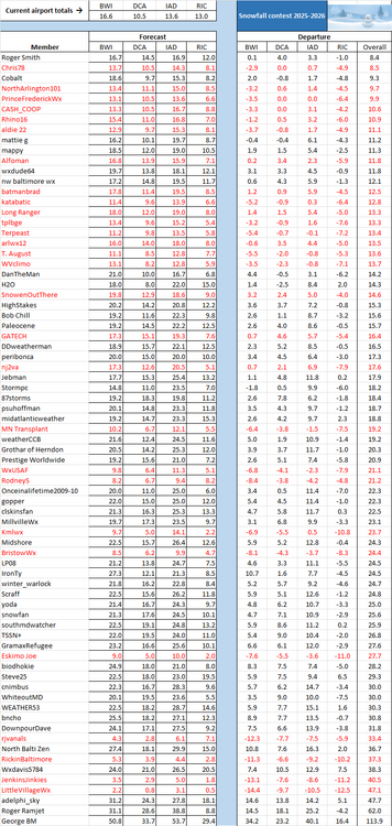
Quite a day in the Mid-Atlantic -- from summer in the early morning to winter in the late morning. That resulted in the following snow totals today: BWI trace, DCA 0.1, IAD 0.6, and RIC 2.0. As a result, our forecasting guru @Roger Smithis the new leader.
-
GFS is correcting… Northwest trend the last three runs.
-

E PA/NJ/DE Spring 2026 Obs/Discussion
BBasile replied to PhiEaglesfan712's topic in Philadelphia Region
For sure. Strongest thunderstorm in 11 years (wind-wise), and then snow cover in less than 24 hours? This winter is even dying well. -
Looks like a big cooldown and chance of some snow over the weekend now.
-
Would be ironic to have one of the least snowiest March on record.
-

Pittsburgh/Western PA WINTER ‘25/‘26
EVLINC64 replied to Burghblizz's topic in Upstate New York/Pennsylvania
NUH-UH ???? -

Richmond Metro/Hampton Roads Area Discussion
migratingwx replied to RIC Airport's topic in Mid Atlantic
CLI says 2" recorded today at RIC -
Radar would have suggested a few inches across CT over the past 6 hours, but in reality, NADA...
-
Virga stein
-

Pittsburgh/Western PA WINTER ‘25/‘26
Gordo74 replied to Burghblizz's topic in Upstate New York/Pennsylvania

-
80 Degrees to Ripping Snow: March 12th
Stormchaserchuck1 replied to SnowenOutThere's topic in Mid Atlantic
That 77F at 2am on March 12 is impressive.. and they were saying 24 hour temp change, that's an impressive 12 hour temp change! -
I bet DC has never had a day with its high at midnight and its low at 1:30 p.m.!
-
Loving the tenor this month