All Activity
- Past hour
-
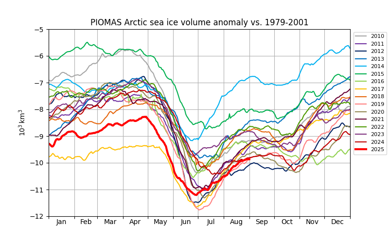
PIOMASS sea ice volume is currently number 2 behind 2012. Volume losses were unusually low this year in June, similar to 2017 in that regard.
-
-
Hazardous Weather Outlook National Weather Service State College PA 402 AM EDT Thu Sep 4 2025 PAZ004>006-010>012-017>019-024>028-033>037-041-042-045-046-049>053- 056>059-063>066-050815- Warren-McKean-Potter-Elk-Cameron-Northern Clinton-Clearfield- Northern Centre-Southern Centre-Cambria-Blair-Huntingdon-Mifflin- Juniata-Somerset-Bedford-Fulton-Franklin-Tioga-Northern Lycoming- Sullivan-Southern Clinton-Southern Lycoming-Union-Snyder-Montour- Northumberland-Columbia-Perry-Dauphin-Schuylkill-Lebanon-Cumberland- Adams-York-Lancaster- 402 AM EDT Thu Sep 4 2025 This Hazardous Weather Outlook is for central Pennsylvania. .DAY ONE...Today and tonight. Strong to severe thunderstorms with damaging winds are possible today.
- Today
-

2025 Atlantic Hurricane Season
BarryStantonGBP replied to BarryStantonGBP's topic in Tropical Headquarters
OI LAD @GaWx -

Eastern Tropical Atlantic Wave - 40/80
GaWx replied to BarryStantonGBP's topic in Tropical Headquarters
0Z: -Icon is a little SW of the 12Z with it at 18N, 55W at 180 moving WNW -The UKMET on again off again is now back to off with the low not strong enough to be classified a TD. -Early in the GFS run, it’s a little N of the 18Z position at 138 hours. -
Release the Epstein files!

-
The actual correlation to the Winter NAO consists of two area: cold up north, and warm below New Foundland correlates with Winter +NAO and warm up north and cold below New Foundland correlations with Winter -NAO. Erin really did a lot of cooling in the southern region, but it's actually a 5-month average (May-Sept), and May-Aug so far is running +NAO probability because the north part has been so cold. Here's the Summer N. Atlantic SSTAs -> Winter NAO correlation (default positive) Here is May-Aug so far: Weak Winter +NAO signal overall. Edit: ^That was only August, but it does show how we are progressing lately. Here is May-Aug.. it comes out at a +0.22 DJFM mean NAO prediction
-
 I think people need to temper their expectations a bit. It's not supposed to be nonstop 80s and 90s all summer long. I was reading P. Vanderbilt Spader's weather record for New Brunswick, New Jersey. He installed self-registering max/min thermometers on February 1, 1857, with periodic records back to 1847. And it looks very similar to those old Newark records you shared earlier this summer. I'm not sure what's going on here, but the summer temperature and precipitation regime looks more like New Brunswick, Canada than New Brunswick, New Jersey. Looks cold and wet. Very weird. Weather Record for New Brunswick, New Jersey, 1847-1890 - Google Books
 -
The Wednesday evening hi-res guidance is very encouraging for Thursday late afternoon / early evening convection, especially over central Maryland.
-
Thanks for the update, Don. Akron, Ohio saw its driest month on record. Not just driest August, but driest of any month. Looking over the numbers, it looks like Ohio had either its driest or second driest August on record. Pennsylvania looks like a top 5 driest August as well. I didn't look at any other states, but it looks like dryness prevailed from Missouri to Maine.
-

2025 ENSO/Winter Speculation
Prismshine Productions replied to 40/70 Benchmark's topic in New England
2013/14 is an analog... Sent from my SM-S166V using Tapatalk -
I said for here, meaning over here towards the coast. Places N and W of the cities haven't done as well, and part of that is the avg annual snowfall there is higher.
-
Looks like canonical Niña. I’m looking for JB to cool this down for his final outlook considering he tends to do that when it isn’t cold along the NE coast. Also, here’s some big hints within this that he will do just that: August 29, 2025 The threat of a cold winter looms. Plenty of blocking is expected over the Arctic. A prominent Alaskan ridge should lead to plenty of cold air. Another Thanksgiving to Christmas cold period is on the table, but this time it may not break. The heart of the winter looks coldest relative to average, but there are questions as to how it starts and ends.
-
Gotcha, yeah he's off Silver Ln and Simmons Rd right by Rentchler Field. I've brought him to Martin Park on Burnside Ave and it seems...sketchy to say the least. Which I already knew from playing baseball there in 2017. There was a shooting at his place a year and a half ago.
-

September 2025 OBS-Discussion centered NYC subforum
xram replied to wdrag's topic in New York City Metro
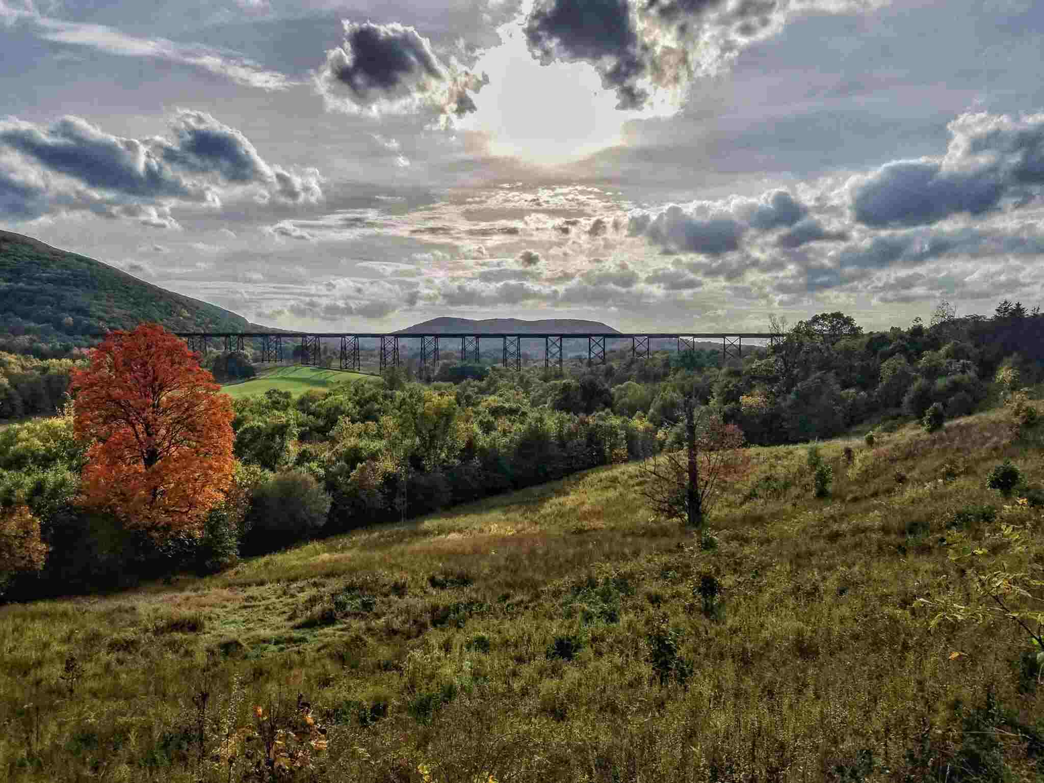
I never get sick of that view. I live less than a mile from the Viaduct. That view never disappoints in the fall or anytime of year really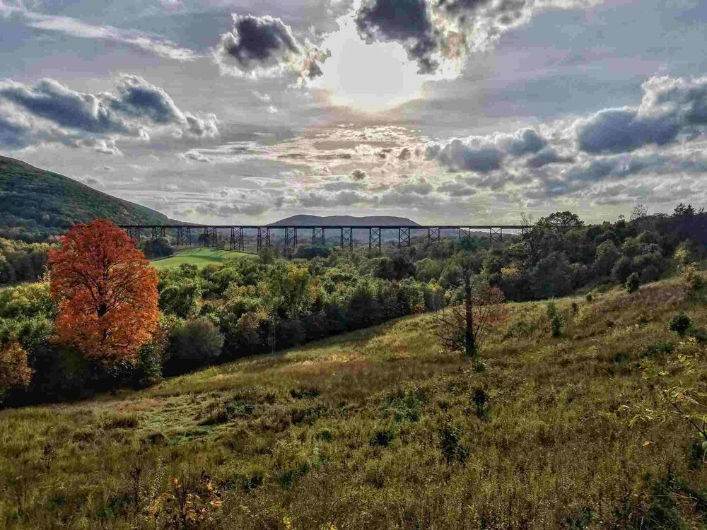
-
mowed the grass this past saturday and it's barely grown a tenth of an inch, usually its faster. turning brown as well.
-

2025-2026 ENSO
Stormchaserchuck1 replied to 40/70 Benchmark's topic in Weather Forecasting and Discussion
It's been pretty constant central-subsurface cold since the 23-24 El Nino. You can see how the surface has been running much warmer than the subsurface (more credence to RONI), which makes me think that when we finally do shift to El Nino, it will be warmer than the subsurface Kelvin Waves would indicate. Pretty good chance we go to El Nino in 2026 or 2027. -
Which ones? I have been below average every Winter since 15-16, and there have been 6 La Nina's in that time (RONI).
-
Sadly for here in Northern Middle & West TN. The rains have all but disappeared. Nashville got some today but the drought is really setting in & the trees are flat out turning yellow to brown. We are going to have a very early looking fall. By the end of September the leaves will be gone. My yard is completely brown. Even my neighbors who have sprinklers have given up. No way to keep up with how much it would cost to keep green. It will be interesting how many trees die from this drought. I remember the last one we had killed many. We sadly can only get a few dust splattering drops.
-
2025-2026 ENSO
Stormchaserchuck1 replied to 40/70 Benchmark's topic in Weather Forecasting and Discussion
+NAO's run wetter, so when that phases with the northern stream, as rare as it is, it produces a lot of good snowfall. -
Im watching a winter outlook on YouTube and they got this winter being the most memories winter in a long time for the east lol
-
We had a couple hours of early morning rain..1.24" Total. Jonesville proper, 2.18". Thar same pecip field moved over your area and kept expanding and backfilling. I'm expecting early cold and snow. May be another November Snowfall. Hopefully, an old fashioned big one.
-
East Hartford is home. It gets a bad rap from some because during and after WWII it grew exponentially and most of the agricultural land became housing and apartments that until recently haven’t really been redeveloped and modernized. The town basically fully built out by the 70s and had some bad commercial owners. Most of EH is actually really suburban outside of the main travel corridors.
-
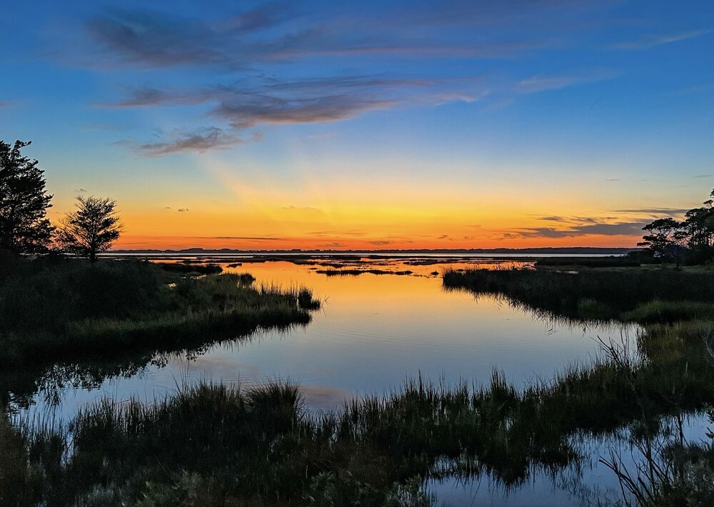
Beautiful sunset tonight on Assateague Island. The weather has been beautiful the past two days down here in Ocean City.
-

2025-2026 ENSO
so_whats_happening replied to 40/70 Benchmark's topic in Weather Forecasting and Discussion
Not necessarily but it should help chances.