All Activity
- Past hour
-

E PA/NJ/DE Summer 2026 Obs/Discussion
Chadzachadam replied to PhiEaglesfan712's topic in Philadelphia Region
DPs are still nasty this morning, hanging in the low-mid 70s. should get some relief this evening and tomorrow -
Issuing a winter outlook, even a preliminary one, in August is dicey.
-
2019 was at least dry until mid-October, which helped lower the humidity. September 2018 had multiple days of monsoon rains, amounting to almost 10 inches, and only 14 days with no precip.
-

2026-2027 Record-breaking El Nino
Typhoon Tip replied to Stormchaserchuck1's topic in Weather Forecasting and Discussion
Heh... that doesn't even look like a climate inference here. It looks like a straight up geophysical response. Like in the model process, the boreal Pacific/seasonality presses up against that colossal heat source between the Date Line and Central N/A. Rather simplistic arithmetically, too. Like two factored: seasonally cooling N + supremely hot S = boom jet. It brings to mind ... I haven't heard much talk about AR phenomenon. "Atmospheric Rivers" are a real thing. Their identity I've recently felt has been over applied and (no pun intended) thus watered down. Like every time California was getting a cut-off low over the lower G of Alaska, sending spoke waves of wind and rain into the west coast we were getting AR headlines and I'm like no - no really. I mean it may be that the definition can apply? But the origination of the Atmospheric River identification of phenomenon was linked to what is called a "Pineapple Express" - from HA, a fire hose sets up... and it's more like a hemispheric event than a low pattern ordeal. Such that those Cali reservoir recovery events during ( surprisingly) La Ninas. Whole nother weirdness... Anyway, the pummeling California took in 1983 was (apparently) tied to a super Nino of the era; now that was an AR/Pineapple Express. So, the stuff above can be right in principle, but the placement could end up N of that axis just the same. And maybe, just maybe is an early hint -
Excessive heat warning once again. Currently at 10:45 am it is 92/83 for a feels like of 118. And it absolutely feels like it too.
-
Recorded 0.1" of rain from the surprise morning event. Definitely a wetter period as of late with recordable rain for 5 of the last 7 days, though totals have been small, only totaling up to 0.47". Guess I don't have to water so much this week.
-
It was worse in 2019.
-
Burn off or=ccuring
-

2026-2027 Record-breaking El Nino
donsutherland1 replied to Stormchaserchuck1's topic in Weather Forecasting and Discussion
The latest C3S seasonal forecast shows the strong El Niño's growing influence on what will likely be a very active subtropical jet during the fall and at least the first half of winter.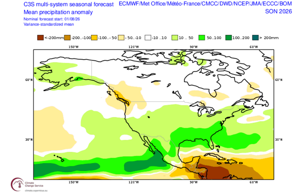
-
I really hope they're wrong on this. September-October 2018 was just horrible. If I wanted Florida weather I'd move there.
- Today
-
Hmm, forecast looks like a Nino, and it feels like a Nino out there. oday Isolated showers and thunderstorms after 2pm. Mostly sunny, with a high near 88. North wind around 5 mph. Chance of precipitation is 20%. Tonight Isolated showers and thunderstorms before 9pm. Mostly clear, with a low around 67. Calm wind. Chance of precipitation is 20%. Wednesday Sunny, with a high near 88. Calm wind becoming west around 5 mph in the afternoon. Wednesday Night Partly cloudy, with a low around 70. Calm wind. Thursday A chance of showers before 11am, then a chance of showers and thunderstorms between 11am and 2pm, then showers and possibly a thunderstorm after 2pm. High near 86. Calm wind becoming west around 5 mph in the afternoon. Chance of precipitation is 80%. New rainfall amounts between a quarter and half of an inch possible. Thursday Night Showers and thunderstorms before 11pm, then a chance of showers. Low around 67. Chance of precipitation is 80%. New precipitation amounts between a quarter and half of an inch possible. Friday A chance of showers after 2pm. Partly sunny, with a high near 84. Chance of precipitation is 40%. Friday Night A chance of showers. Mostly cloudy, with a low around 67. Chance of precipitation is 40%. Saturday Showers likely, mainly after 2pm. Mostly cloudy, with a high near 82. Chance of precipitation is 60%. Saturday Night Showers likely and possibly a thunderstorm before 8pm, then a chance of showers and thunderstorms between 8pm and 2am, then a chance of showers after 2am. Mostly cloudy, with a low around 67. Chance of precipitation is 60%. Sunday A chance of showers. Partly sunny, with a high near 84. Chance of precipitation is 30%. Sunday Night A chance of showers. Partly cloudy,
-
(002).thumb.png.6e3d9d46bca5fe41aab7a74871dd8af8.png)
Central PA Summer 2026 Discussion/Obs Thread
ChescoWx replied to Voyager's topic in Upstate New York/Pennsylvania
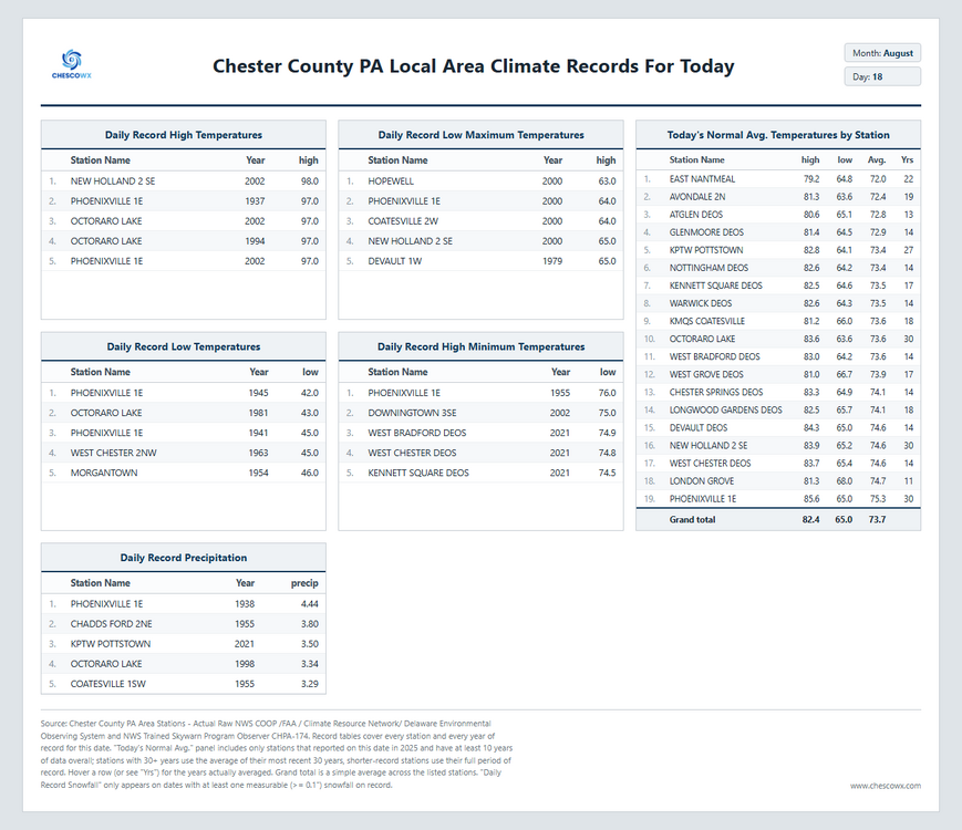
Most spots dry out a bit today with sun returning we could see a couple showers toward evening especially across southeast parts of the area. A bit less humidity today and especially tomorrow before the chances of showers increase again by Thursday afternoon into the night. The weekend looks to continue shower chances as we continue to erode any drought concerns across the area.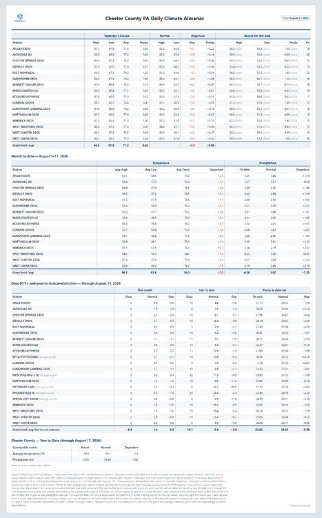
-
E PA/NJ/DE Summer 2026 Obs/Discussion
ChescoWx replied to PhiEaglesfan712's topic in Philadelphia Region
Most spots dry out a bit today with sun returning we could see a couple showers toward evening especially across southeast parts of the area. A bit less humidity today and especially tomorrow before the chances of showers increase again by Thursday afternoon into the night. The weekend looks to continue shower chances as we continue to erode any drought concerns across the area.
-

2026-2027 Record-breaking El Nino
Maestrobjwa replied to Stormchaserchuck1's topic in Weather Forecasting and Discussion
As someone who lives in the la Nina screw zone (central MD) if we gotta get one I'd much rather it be the earlier 27-28 and 28-29 (because they always seem to double-dip) so we can maybe try for another nino for low solar minimum time -
0.02" from yesterday's event. So stupid.
-

Augdewst 2026: Summer's Last Stand
weatherwiz replied to Prismshine Productions's topic in New England
This would probably be the resolution -

Augdewst 2026: Summer's Last Stand
dendrite replied to Prismshine Productions's topic in New England
Does he have an archive of vis captures from great coastal misses over the North Atlantic? -
Augdewst 2026: Summer's Last Stand
dendrite replied to Prismshine Productions's topic in New England
I think the MPAS is the v2 Scott referred to. The other has the broken FV3 core. Someone else more in the know can correct me if I’m wrong. -
Augdewst 2026: Summer's Last Stand
dendrite replied to Prismshine Productions's topic in New England
Actually I’m a meaty urologist, but this was the closest tag we had.
-

2026-2027 Record-breaking El Nino
LakePaste25 replied to Stormchaserchuck1's topic in Weather Forecasting and Discussion
Carryover Ninos/ENSO neutral are usually a gold mine for E US winters. Another reason I want this El Niño to be as strong as possible. -
And you call yourself a meteorologist.
-
Records: Highs: EWR: 97 (2002) NYC: 94 (2002) LGA: 95 (2002) JFK: 93 (1995) Lows: EWR: 52 (1941) NYC: 55 (1915) LGA: 59 (1941) JFK: 58 (1963) Historical: 1779: William Dunbar observed and wrote about the passage of a hurricane's eye over New Orleans. (Ref. AccWeather Weather History) 1879: This storm is often called "The Cape Cod Hurricane of 1879" An extreme hurricane moved north and went on the rampage from the Bahamas to Eastport, Maine (track to the right). In the immediate Mid-Atlantic region, the track of this storm ran very close to a Wilmington - Elizabeth City, NC axis to just southeast of Norfolk. It was considered one of the most severe to strike coastal Virginia in the last half century and was probably as severe as the June 1825 storm. The passage of this storm was accompanied by a rapid pressure fall from 29.58 inches at 9:00 am to 29.12 inches at 11:15 am on the 18th, which was the lowest pressure observed in the storm. Five-minute sustained winds rose to 76 mph with gusts toward 100 mph at Cape Henry, before the anemometer was destroyed. (Ref. for 1879 Hurricane) 1906: Unusual tropical storm came up into the Gulf of California, giving Needles, California 5.66 inches of rain, twice what would normally be seen in a year. (Ref. AccWeather Weather History) 1909: Bagdad, in San Bernardino County of California, reported no precipitation for 993 consecutive days from this date to 5/6/1912. (Ref. Wilson Wx. History) 1917: The high temperature in Death Valley, CA was 119°. This ended a record streak of 43 consecutive days with the high temperature 120° or hotter. (Ref. Wilson Wx. History) 1925 - During the late morning hours a severe hailstorm struck southeastern Iowa completely destroying crops along a path six to ten miles wide and 75 miles long. The hail also injured and killed poultry and livestock, and caused a total of 2.5 million dollars damage. The hailstorm flattened fields of corn to such an extent that many had to leave their farms in search of other work. It was one of the worst hailstorms of record for the nation. (The Weather Channel) 1936: An average of the temperatures at 113 reporting stations in Iowa measured 106.5°, making this the hottest day in the state's history as of this date. (Ref. AccWeather Weather History) 1943: Autumn was in the air with record low temperatures of 41° at Grand Rapids, MI and 43° at Muskegon, MI. (Ref. Wilson Wx. History) 1953: Four heifers near St. Martin, MN were lucky. A tornado picked them up and set them back down again, unharmed. (Ref. AccWeather Weather History) 1955: Diane crossed MD gave 1.09 inches of rain on 18th & brought flooding because of the heavy rain by the earlier storm Connie. Hurricane Diane became the second hurricane to strike the United States East Coast in less than a week. Diane weakened as it crossed colder water left in the wake of Hurricane Connie, but the rainfall did not diminish. The storm moved across the North Carolina coast then recurved to the northeast, passing very near Philadelphia, PA then to the southern coast of New England. Diane's heavy rains, up to 13 inches in the Poconos, added to those of Connie 5 days earlier, brought massive flooding to the Mid Atlantic and the northeast. Westfield, MA recorded 18.15 inches of rain in just 24 hours to establish the 24 hour mark for the state. Boston, MA had 8.40 inches, their greatest 24 hour total ever. At one point, 40% of Worcester, MA was under water. Up to 200 people were killed with $800 million dollars in damage.(Ref. AccWeather Weather History) (The Weather Channel) (More Information About Diane) Diane's Storm Track - NOAA. Gov. - National Hurricane Center 1980: Three inches of snow fell at McCall, ID, a sign of the changing seasons. (Ref. AccWeather Weather History) 1983 - Hurricane Alicia ravaged southeastern Texas. The hurricane caused more than three billion dollars property damage, making it one of the costliest hurricanes in the history of the U.S. Just thirteen persons were killed, but 1800 others were injured. The hurricane packed winds to 130 mph as it crossed Galveston Island, and spawned twenty-two tornadoes in less than 24 hours as it made landfall. (The Weather Channel) (Storm Data) 1987 - Thirteen cities in the eastern U.S. reported record high temperatures for the date, including Orlando FL with a reading of 98 degrees, and Portland ME with a high of 94 degrees. Newark NJ reached 90 degrees for the thirty-sixth time of the year, their second highest total of record. (The National Weather Summary) 1988 - Twenty-two cities, from the Carolinas to the Upper Ohio Valley, reported record high temperatures for the date, pushing the total number of daily record highs since the first of June above the 1100 mark. Afternoon highs of 102 degrees at Greensboro NC and 105 degrees at Raleigh NC equalled all-time records. Evening thunderstorms in Montana produced wind gusts to 75 mph at Scobey. (The National Weather Summary) (Storm Data) 1989 - Thunderstorms over the Middle Atlantic Coast Region and the Upper Ohio Valley produced torrential rains in eastern Virginia during the late morning and afternoon hours. Totals ranged up to twelve inches at Yorktown. Williamsburg VA was deluged with 10.78 inches of rain between 6 AM and 10 AM, with 6.72 inches reported in just two hours. Flash flooding caused nearly twelve million dollars damage in Accomack County VA. Early evening thunderstorms in the Central High Plains Region produced walnut size hail and wind gusts to 80 mph around Casper WY. Thunderstorms produced locally heavy rains in the Yellowstone Park area, causing fifteen mudslides. (The National Weather Summary) (Storm Data) 1993: A squall line developed across western Iowa sending damaging winds over the west central portion of the state for a brief time. A tornado touched down west of Breda causing extensive damage to a farmstead and minor damage to another. Also, an 80 foot barn was destroyed by the tornado. High winds from the storm also overturned a tractor semi-trailer north of Carroll and caused extensive crop damage in the area. (Ref. Wilson Wx. History) 1994: Residents who were in the path of the 1994 Lahoma storm in Oklahoma, awoke on this morning to find a strange world. The devastating wind and hail storm on the previous day had stripped nearly every tree of leaves in the Lahoma and Drummond areas. That, along with plowed fields from harvested wheat, left the August landscape looking eerily more like mid winter. Hail was still on the ground in some protected areas around Lahoma more than 24 hours after the storm. (Ref. Wilson Wx. History) 2005: 27 tornadoes were documented in WI today, thus establishing its record for the greatest number of tornadoes reported in a calendar day. Most were F0 or F1, but an F3 storm killed 1, hurt 23 between Fitchburg and Rockdale. 4 other injuries reported. (Weather Guide Calendar with Phenomenal Weather Events 2011 Accord Pub. 2010, USA) (More Information About These Storms) 2008: During seven days in Florida, August 18–24, 2008, eleven people died and thousands of homes plus roads were damaged, from 60 mph winds and flooded rivers or tornadoes, as Fay traveled through the entire state. Fay was the first storm on record to hit the same U.S. state on four separate occasions, beating a record set by Hurricane Gordon of 1994, It was just the third storm on record to hit the U.S. at least 3 times. Fay was also the first storm to prompt storm warnings for the entire coast of Florida. The four separate landfalls were responsible for every stretch of the Florida coast to receive a Tropical Storm Watch or Warning, or a Hurricane Watch or Warning. The two highest rainfall amounts recorded were 27.65 inches at Windover Farms, 8 miles northwest of Melbourne, Florida, and 27.50 inches at Thomasville, Georgia. The amount of total insured damage compiled by the Property Claim Services of the Insurance Services Office, Inc., was $245 million dollars. This includes $195 million in Florida, $25 million in Georgia, and $25 million in Alabama. Flood damage losses reported by the National Flood Insurance Program were about $36 million dollars. Using a doubling of insured losses to obtain the total damage gives an estimate of Fay’s damage in the United States of about $560 million dollars. Fay's Storm Track - Weather Underground (More Information About Hurricane Fay) (Ref. WxDoctor)
-
I have read (from semi-reliable sources) that the very high arctic...above 80N....has been freakishly cold this summer. What's up with that? Is it a super +AO?
-
77 / 73 Soutern Florida type steam continues today. Enough sun gets min /upper 80. Tomorrow the sunnier day and looks like in the hotter areas a shot at 90. Trough generally into the GL-NE 8/21 - 8/28 with near normal and chances of rain and sotherly flow on the eastern side of the trough. Overall warmer beyond there.
-
73 degree dewpoint at 9 am. nasty. Bring back the drought.