All Activity
- Past hour
-
The winds along the leading edge from yesterday in New Britain
-
I’m expecting an overperform today. The mid level forcing tends to meet or exceed for June. Yesterday with the prevailing low level easterly fetch and overcast was a big sell for rain. Not a repeat. Two completely different setups. More early sun too. Fitting the persistence pattern today with the mid level low swinging through.
-
SPC took out general tstms for SNE 13z update? I don't think so. Plenty of sun, adequate CAPE, and cold temps aloft as a solid s/w trof swings through. HRRR and RRFS clearly show cells ern MA and the S Coast. 12z RRFS gets carried away it seems Buzzards Bay area showing a li'l 2.78" max but the 06z had a .70" max in the same area. Meso models all along have shown decent potential S Coast today, so no reason to think it will not happen. Also, storms dropping from the N often over-perform in SNE and it's how CC and the S Coast do their best.
-
BOOTYLICIOUS?
-
Clouds dropping SE
-
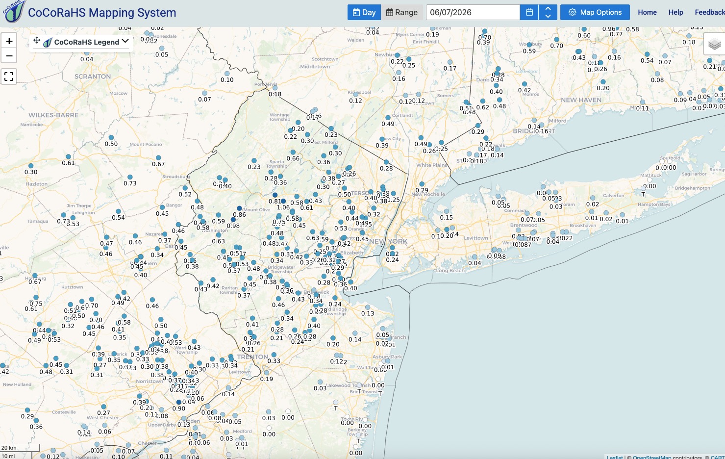
Interesting, I live very close to 78 near Liberty Corner, and from the map it looks like my area got .42+-, but evidently the wind blew the top of my garbage can open early in the storm (so that was the bang I heard lol), and when I went out this morning I would estimate there was at least an inch of water in the can that I had to dump out. I realize that's not scientific and the sides of my garbage can are not perfectly vertical etc. but It seems like I had to have gotten at least .75 here. Very very localized I guess. My lawn is grateful because I don't have a sprinkler system...
-
Good old Steve D is going down with the ship this year I guess lol. That clown is insisting that this is only going to be a moderate to “maybe low-end strong” El Niño and that all the models, obs, data and experts are going to be dead wrong. Good Lord, that guy is the worst meteorologist in history. Total buffoon. And he’s an arrogant, stuck up, pompous asshole to boot. I can’t believe people actually waste their money to subscribe to his garbage
-
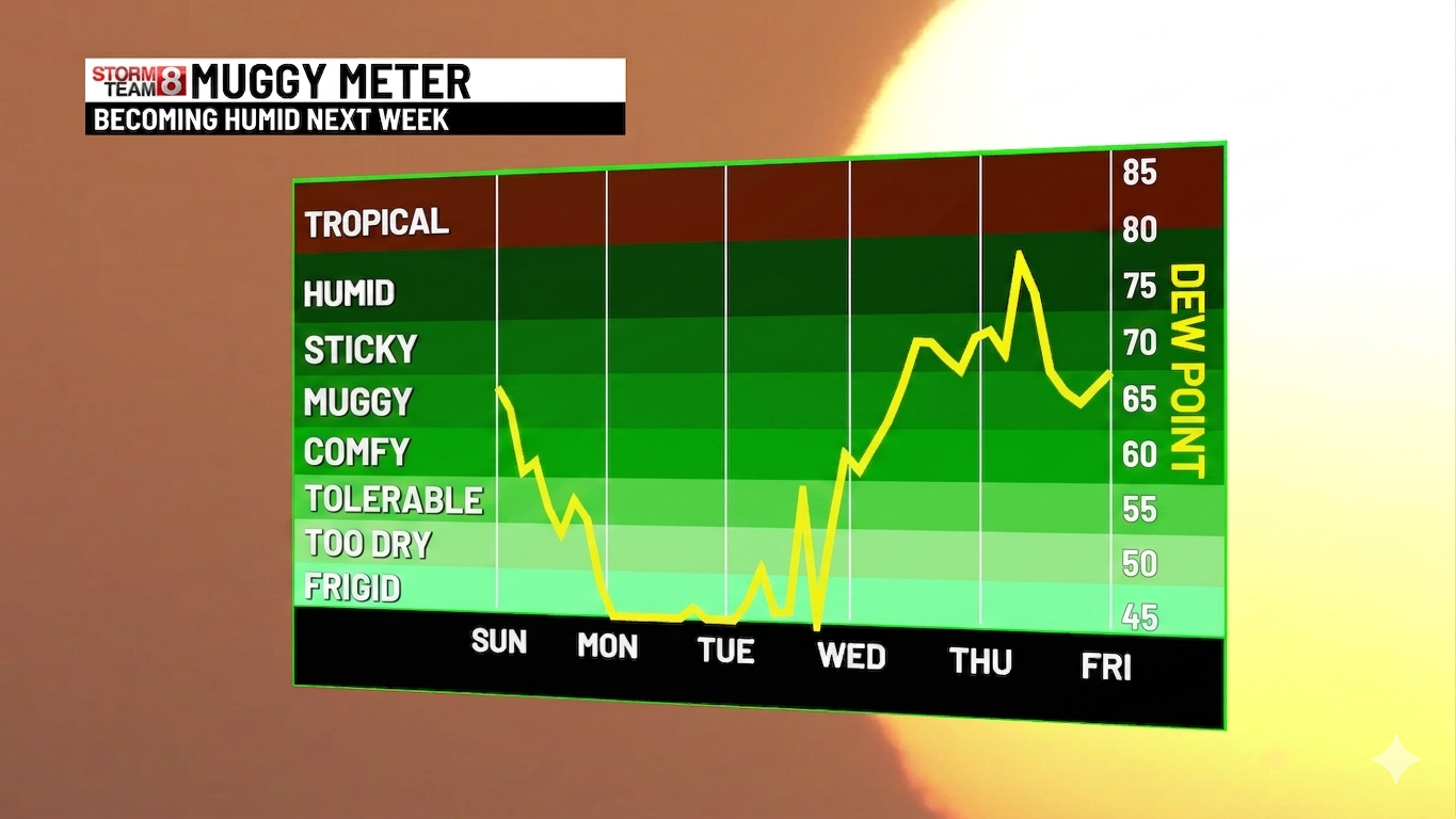
Chance of rain every day the next week here. Very humid this morning.
- Today
-

2026-2027 Super El Nino
George001 replied to Stormchaserchuck1's topic in Weather Forecasting and Discussion
Yeah, definitely an early developing El Niño. Early developing events tend to peak stronger, and it looks like the consensus supports a super peak (which does not surprise me given what the subsurface looked like a couple of months ago). The question now is how will the super Nino affect the weather pattern? I’m thinking since it’s such an early developing event we will likely see the subtropical jet activate in the summer, and have a weaker Atlantic hurricane season than typical. For winter, it’s very early but these super ninos tend to follow a certain pattern (warm and wet in the east) so I would think that’s a good starting point. A bit off topic but I did notice a thing over the years where weenie sentiment tends to be too pessimistic during la Nina’s and too optimistic during El Niños. Has anyone else noticed this? -
The showers dropping in from the north look like weak sauce. 3k tries to fire some isolated convection along the boundary later…we shall see. Setting in by mid June…just like clockwork.
-
(002).thumb.png.6e3d9d46bca5fe41aab7a74871dd8af8.png)
Central PA Summer 2026 Discussion/Obs Thread
ChescoWx replied to Voyager's topic in Upstate New York/Pennsylvania
Temperatures similar to yesterday with highs in the low to mid 80's. We turn a couple of degrees cooler tomorrow. We then start a warming trend with some spots touching 90 degrees on both Thursday and Friday. There will be some chances at a shower by Thursday night.
-
E PA/NJ/DE Spring 2026 Obs/Discussion
ChescoWx replied to PhiEaglesfan712's topic in Philadelphia Region
Temperatures similar to yesterday with highs in the low to mid 80's. We turn a couple of degrees cooler tomorrow. We then start a warming trend with some spots touching 90 degrees on both Thursday and Friday. There will be some chances at a shower by Thursday night.
-

Junorch obs and discussion 2026
Damage In Tolland replied to Damage In Tolland's topic in New England
If you don’t dry it off it will look worse with the pollen water spots. I just wiped and dried mine off. Nothing worse that those sticky pollen splotches all over the vehicle -
Woke up to that one last night...think it was around 3am. Very few precipitation issues in Frederick since the La Niña winter ended.
-
Did well here and I'm calling it a lucky over achiever on the rainfall last evening. Picked up .81". Happy about that. Lawn and garden looking happier this morning. Lawns had really started burning by yesterday afternoon. This rainfall will help a bit for a few days at least. Had a few loud booms of thunder and some vivid lightning flashes to go with the wind and rain. Estimated gusts to 40 mph but only very briefly. Great pictures you all posted from last evening. Looks like a short burst of intense heat by late in the coming week. Would love for the LR guidance to be correct about a wetter period for the second half of June with the GOM possibly opening up with a northern transport of moisture over the eastern U.S. Cautiously optimistic. Of course any northward push of gulf moisture will make it feel swampy and that will make it uncomfortable but it is June.

-
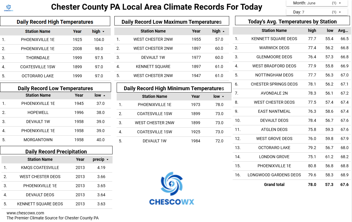
June 7 2011: The Twin Cities reach a high of 103 degrees, shattering the previous record high by 8 degrees. 1939: Grapefruit-sized hail falls in Rock County, killing hundreds of farm animals near Hills. For Sunday, June 7, 2026 1816 - A famous June snow occurred in the northeastern U.S. Danville VT reported drifts of snow and sleet twenty inches deep. The Highlands were white all day, and flurries were observed as far south as Boston MA. (David Ludlum) 1972 - Richmond VA experienced its worst flood of record as rains from Hurricane Agnes pushed the water level at the city locks to a height of 36.5 feet, easily topping the previous record of thirty feet set in 1771. (The Weather Channel) 1987 - Thunderstorms in the Laramie Mountains of eastern Wyoming produced golf ball size hail, and up to five inches of rain in just one hour. Half a dozen cities in the Upper Mississippi Valley reported record high temperatures for the date, including La Crosse, WI, with a reading of 97 degrees. (The National Weather Summary)(Storm Data) 1988 - Snow whitened some of the mountains of northern California and northwestern Nevada. Twenty-six cities in the central and eastern U.S. reported record high temperatures for the date, including Rapid City SD with a reading of 104 degrees, and Miles City, MT, with a high of 106 degrees. (The National Weather Summary) 1989 - Thunderstorms produced severe weather from southern Oklahoma and eastern Texas to northwestern Florida through the day and night. Thunderstorms spawned 22 tornadoes, including a dozen in Louisiana, and there were 119 reports of large hail and damaging winds. A strong (F-2) tornado at Gross Tete LA killed two persons, injured thirty others, and another strong (F-2) tornado injured 60 persons at Lobdell LA. Softball size hail was reported at Hillsboro TX. (The National Weather Summary) (Storm Data)
-
Had a good time yesterday chillin with family n friends at the grad party. Beautiful day with a Lake breeze that kept it comfortable in the 70's. Sun was still warm tho. Today will be different with a stiff Lake wind with temps in the 60's.
-
https://x.com/iembot_okx/status/2063616840316641340?s=46&t=m4Eqkekadb-JCXTm7k-Txg
-
A bit..ton of lightning and torrential downpours. thought my tent was going to wash away
-
Looks good but had to edit it a bit.

-
Not sure anyone saw this but Josh Timlin put together a great page which aggregates all kinds of cool weather maps and data: https://contextclimate.io/#/
-
Got about .25 knocked down the pollen some. But there's plenty more coming off the trees.
-
Correct. Yesterday was glorious. 1st good Saturday weather of year for golf.
-

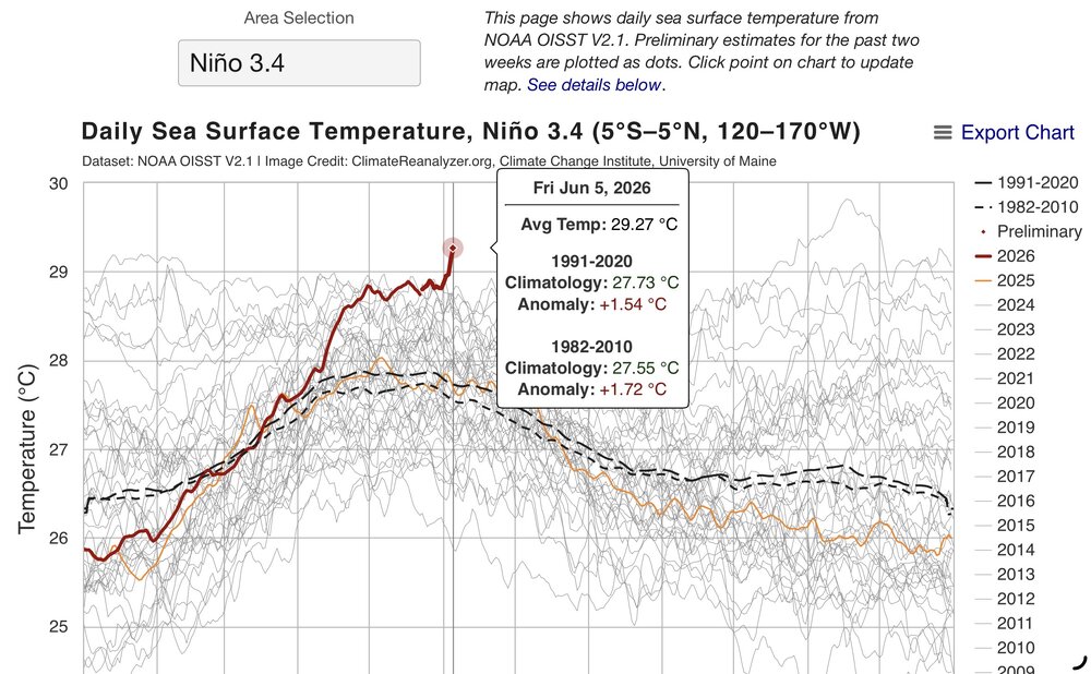
2026-2027 Super El Nino
bluewave replied to Stormchaserchuck1's topic in Weather Forecasting and Discussion
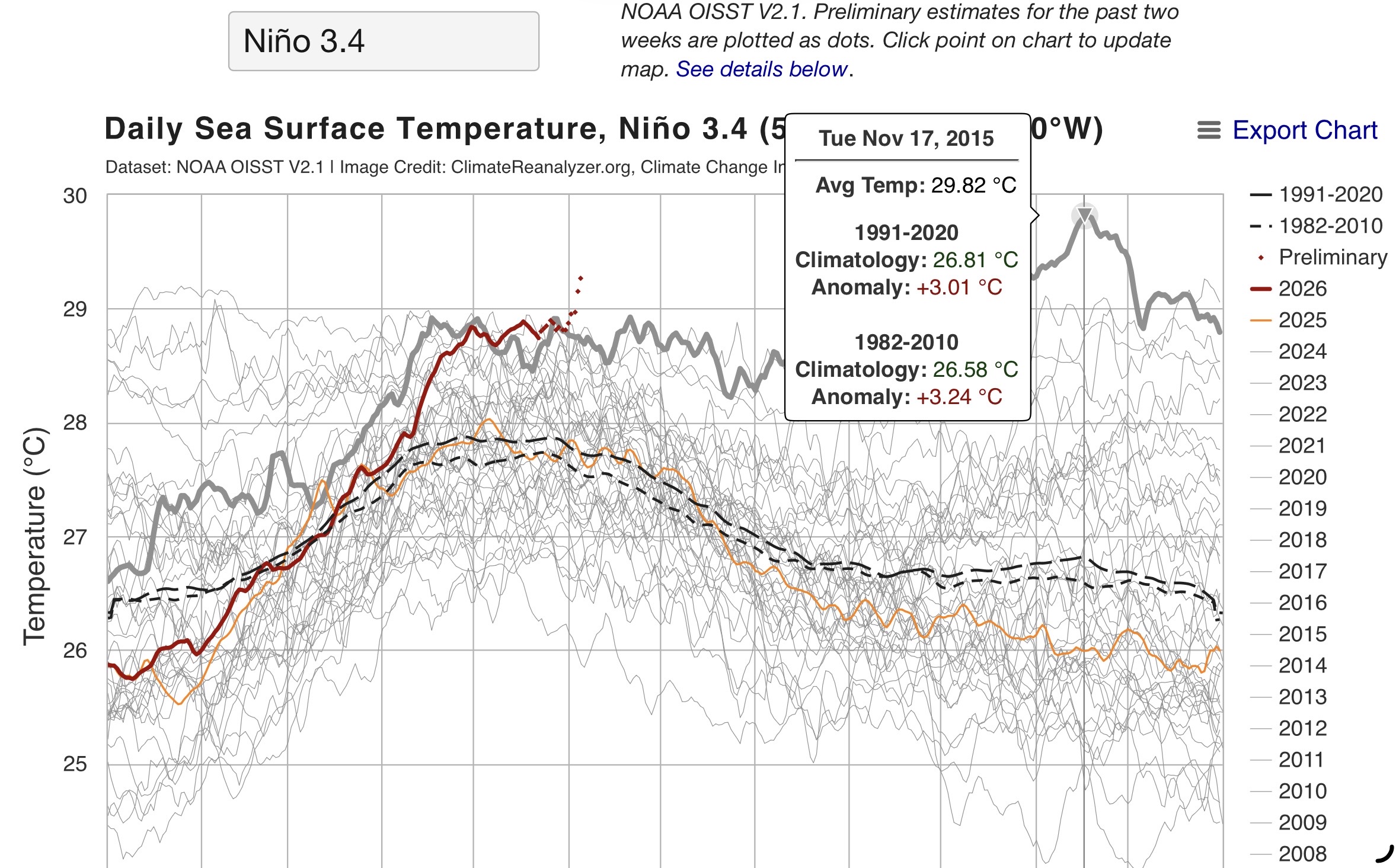
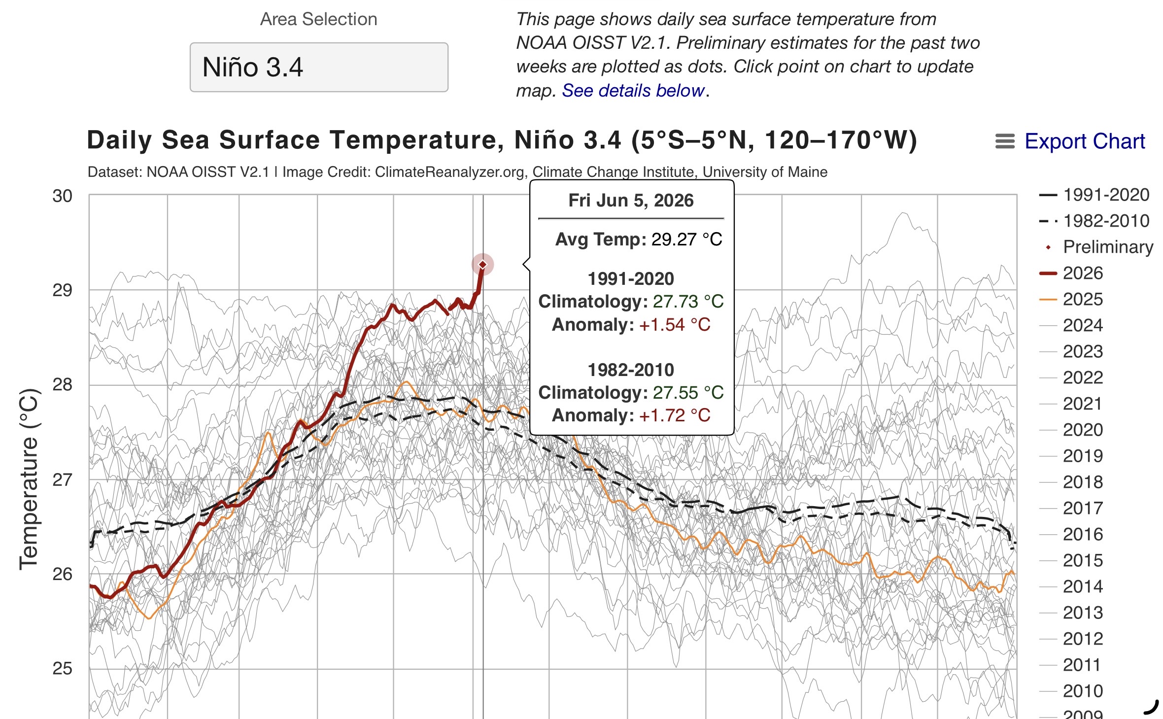
Nino 3.4 getting to 29.27 is really impressive so early in this event. The all-time record was 29.82 back on 11-17-15. They may need to extend the scale since the current forecast peak over is 30°C.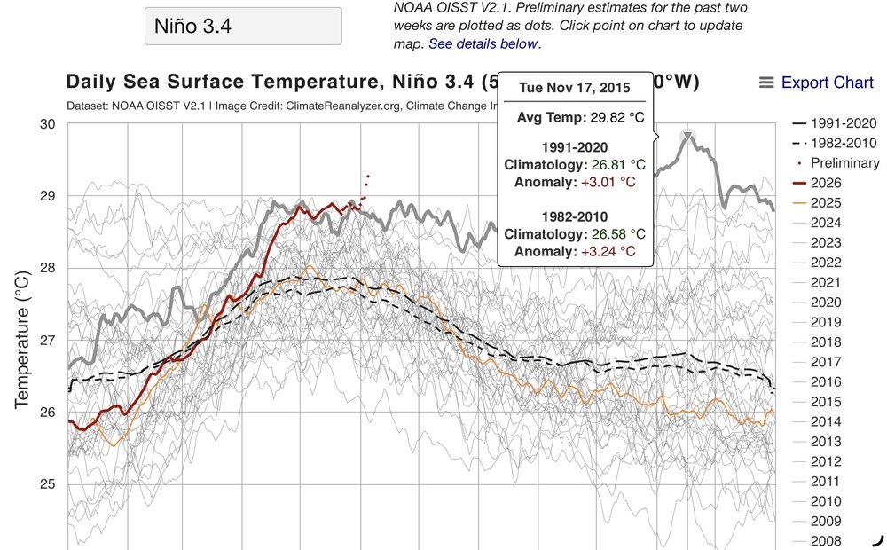
-
Bridgeport: 5 days, 1957, 1984 Islip: 6 days, 1987 New York City-Central Park: 10 days, 1925, 1991 New York City-JFK Airport: 5 days, 1962, 1984, 1988, 1991 New York City-LaGuardia Airport: 9 days, 1991 Newark: 13 days, 1991 White Plains: 5 days, 1957, 1984