All Activity
- Past hour
-
Looks like low 50s for Xmas. Probably 60 or so the day after. Is what it is. Not hating it tbh.
-

December 2025 Short/Medium Range Forecast Thread
Carvers Gap replied to John1122's topic in Tennessee Valley
I think models are in a huge state of flux right now. They were wrong about the Baja lows. They are wrong about over-doing too many NW Pac lows. They could be overdoing the Aleutian and/or NAO and/or AO HL blocking. We have seen modeling miss on HL blocking at exactly this time of year, but we have seen it score. Just too early to tell. -
December 2025 Short/Medium Range Forecast Thread
Carvers Gap replied to John1122's topic in Tennessee Valley
I am mainly confident, because recent Nina climatology suggests there will be 10-14 days of very cold temps sometime between week 2-4 of January. Plus, this seems to be one of those years where warm-ups get shortened as they draw closer. We are in the "warm-up" which was originally modeled to be anomalous. This morning, I was running in 30+mph winds with wind chills in the 20s. If the more aggressive models are correct, the warm-up may be confined to Dec 24-28th. Might be the most talked about warm-up ever to only amount to about 120 hours of AN temps. LOL. I hope that is what happens!!! I am pulling for the NAO to occur, because I am tired of talking about the MJO (no offense meant to those who like it...it is effective). So far, this has fit Nina climatology like a glove.... -

Pittsburgh/Western PA WINTER ‘25/‘26
colonel717 replied to Burghblizz's topic in Upstate New York/Pennsylvania
Looks like this is back building again. I missed out most of the afternoon squalls. Hope these ramp up and head due east.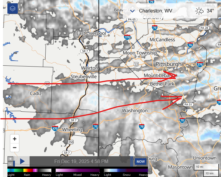
-
Gusted to 49mph in Syosset with the line
-
Meh...72" is like being fringed!
-
Down to 38 . Hopefully snow shortly
-
Hopefully it weakens as it heads east. 6 hours without power now.
-
GFS AI looks good. GFS op barely has precip lol.
-
Yeah that was the ultimate true statement...100% chance of weather and all models and every ensemble agrees on that! Don't forget the known knowns and known unknowns too. You've probably figured out that this place can go from one extreme to another in almost no time! I just await some opportunity for @stormtracker with GUYS, FOLKS, JAWS!!
-

E PA/NJ/DE Winter 2025-26 Obs/Discussion
Hurricane Agnes replied to LVblizzard's topic in Philadelphia Region
I was listening to KYW about an hour ago and the traffic report was already talking about down trees (e.g., in Delco). But flying cows! Temp here has dropped over 15 degrees from my earlier high and I'm down to 40 with dp 28. -
From now until about 6:30 or so.
-
intense winds here with the squall line and thunder
-

E PA/NJ/DE Winter 2025-26 Obs/Discussion
Birds~69 replied to LVblizzard's topic in Philadelphia Region
I'd be on pins and needles if this were to happen tomorrow night during this time frame and probably head to the bar who most likely have a backup generator. Birds game time tomorrow/Saturday at 5:00 p.m.... -
Timing ?
-
Todays Euro Weeklies are looking better/pretty good for 1/12-2/1. See the main ENSO thread for maps/more details if interested.
-

E PA/NJ/DE Winter 2025-26 Obs/Discussion
BBasile replied to LVblizzard's topic in Philadelphia Region
With the 1-2 inches of rain today and all that snow melt, definitely gonna be some downed trees and power lines. -

December 2025 Short/Medium Range Forecast Thread
jaxjagman replied to John1122's topic in Tennessee Valley
Yeah but you can use Cyclonic for free,that sight is more or less click bait,open my wallet https://cyclonicwx.com/sst/ -
squall line here. Windy but not as bad as earlier
-
E PA/NJ/DE Winter 2025-26 Obs/Discussion
Hurricane Agnes replied to LVblizzard's topic in Philadelphia Region
High Wind Warning was issued for metro Philly -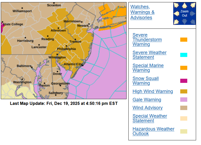
-
E PA/NJ/DE Winter 2025-26 Obs/Discussion
BBasile replied to LVblizzard's topic in Philadelphia Region
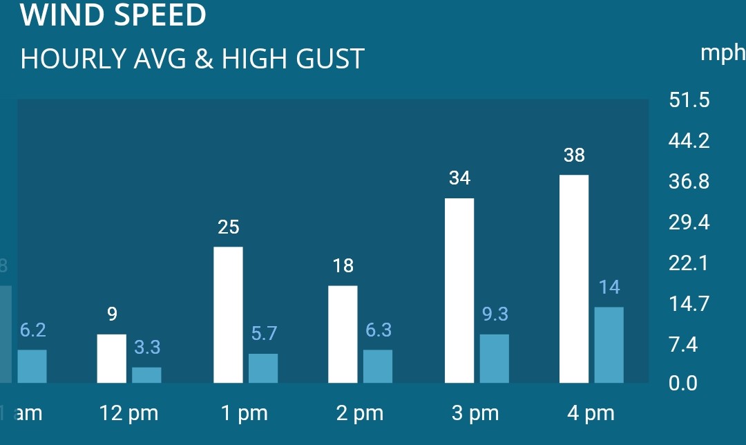
Love that roar of the wind. Peak gust at 38 MPH so far.
-
I don't ever recall seeing a short term upgrade to a HWW, usually it's the opposite Wind events have definitely gotten more intense over the years
-
E PA/NJ/DE Winter 2025-26 Obs/Discussion
Birds~69 replied to LVblizzard's topic in Philadelphia Region
Haven't really visited the Mid-Atlantic threads this year but I would put the over/under Ji cancels at 5 so far and it's not even officially winter yet... (Met winter,yes) -
Pain.
-
I am in the Bahamas for Dec. 18 - 30................................ This tropical touch is heavenly............. Why couldn't we have 70 in D.C. for December 25?