All Activity
- Past hour
-

Jan 30th-February 1st 2026 Arctic Blast/ULL Snow OBS Thread.
TellicoWx replied to John1122's topic in Tennessee Valley
Hopefully, it will improve here (have a bad feeling it won't tho), stopped for awhile now, dusting blowed off, and bare ground. -
So, we're just going to do this weekly until spring?
-

February 2026 Medium/ Long Range Discussion: Buckle Up!
Amped replied to Weather Will's topic in Mid Atlantic
And the second storm just misses Atlanta with the jackpot, otherwise it would be 2 20"+ storms in 72 hrs. Has to be one of the most entertaining fantasyland runs in years. -
I think the state record is -37, lets shoot for that.
-

Jan 30th-February 1st 2026 Arctic Blast/ULL Snow OBS Thread.
BlunderStorm replied to John1122's topic in Tennessee Valley
Wat!? Unless he's on Beartown or up on Big A no shot. I'd be shocked if Lebanon went nuclear and Honaker didn't with how the radar has presented. That said microclimates have shocked me in the past. That said I like this drone shot he did which looks about right. https://x.com/i/status/2017405886688354344 -

Jan 30th-February 1st 2026 Arctic Blast/ULL Snow OBS Thread.
John1122 replied to John1122's topic in Tennessee Valley
Nearly 5 inches into it, MRX upgraded my 1/2 inch forecast to 1-2 inches. -
The “I bring the mojo” Jan 30-Feb 1 potential winter storm
CoolBreeze replied to lilj4425's topic in Southeastern States
Flurries have started here too! -

February 2026 Medium/ Long Range Discussion: Buckle Up!
Fozz replied to Weather Will's topic in Mid Atlantic
In long range GFS world, North Carolina is the new Jay Peak. -
Jan 30th-February 1st 2026 Arctic Blast/ULL Snow OBS Thread.
Scottie16 replied to John1122's topic in Tennessee Valley
Lower level water vapor filling back in. . -

E PA/NJ/DE Winter 2025-26 Obs/Discussion
RedSky replied to LVblizzard's topic in Philadelphia Region
Weird variations out there i have 7F but a cluster of -2 to -6F central Bucks Lehigh Valley in the range of 6F to 8F -
 Officially a trace on record for GSO for Friday
 -

Richmond Metro/Hampton Roads Area Discussion
overcautionisbad replied to RIC Airport's topic in Mid Atlantic
Euro AI.thumb.png.cb6523877f07af59d06fa2f64281c84e.png)
-

The “I bring the mojo” Jan 30-Feb 1 potential winter storm
wxdawg10 replied to lilj4425's topic in Southeastern States
i'm so confused. nothing makes sense. dry slot, no slot, a foot of snow, no snow, who the hell knows. goodnight -

The “I bring the mojo” Jan 30-Feb 1 potential winter storm
knowledgeispwr replied to lilj4425's topic in Southeastern States
Flurries in SW Winston-Salem. -
Down to 4…
-
Jan 30th-February 1st 2026 Arctic Blast/ULL Snow OBS Thread.
John1122 replied to John1122's topic in Tennessee Valley
I would think it would behave in a normal counter clockwise way. But the edge nearest moved north, south, then east over the last 30 minutes. -

-
Light snow near Walkertown
-

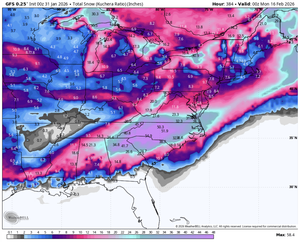
February 2026 Medium/ Long Range Discussion: Buckle Up!
bncho replied to Weather Will's topic in Mid Atlantic
And then there's one last kick to the balls at the very end of the run. Maybe it'll climb up the coast. It's a normal GFS run, lol. -

Jan 30th-February 1st 2026 Arctic Blast/ULL Snow OBS Thread.
Jed33 replied to John1122's topic in Tennessee Valley
It’s been so long since I’ve seen a ULL I forget entirely, but seems like the give this kind of presentation on radar. Just kind of spinning around? Idk I may be grasping for straws here, but yes it’s odd for sure. -
Richmond Metro/Hampton Roads Area Discussion
overcautionisbad replied to RIC Airport's topic in Mid Atlantic
DT is concerned forecasts will bust -

The “I bring the mojo” Jan 30-Feb 1 potential winter storm
DC2Winston replied to lilj4425's topic in Southeastern States
First flurries of the night - here by Wake campus, Reynolda Village. . -
Nice. We should see flurries soon surely.
-

2025-2026 Fall/Winter Mountain Thread
Rainforrest replied to Buckethead's topic in Southeastern States
Just topped 1”with moderate snow.


.png.425ec24d9e60c66bb720f4a969132ebe.png)