All Activity
- Past hour
-
I hear this is his first stop! LOL!
-

2026-2027 Super El Nino
GaWx replied to Stormchaserchuck1's topic in Weather Forecasting and Discussion
The TAO buoy data found at the link below totally confirms Roundy’s noting of the lack of a consistent 30C isotherm E of the Dateline in 1997 when considering SSTs along the 180 and 175W longitudes and comparing those to 1997 to 2026. But it’s also important to keep in mind that there’s been a large amount of GW since 1997. So, that by itself gives 2026 a significant advantage. That’s of course why relative measures have been incorporated in products by NOAA and some others worldwide. That’s the beauty of the SOI. It doesn’t appear to be substantially affected by GW and thus the comparison to past years. -
 random pop up shower overhead, with partly sunny skies very tropical, 84/72
 -

Central PA Summer 2026 Discussion/Obs Thread
canderson replied to Voyager's topic in Upstate New York/Pennsylvania
Looks like major heat comes back middle to late next week as they ridge out west will move over us. Not quite as hot as the records we just experience. And there are signs it’ll be short lived as a big BN ridge wants to take over the NE/mid Atlantic. -
Will that blob to my west make it over the mountains? Stay tuned
-
 Squall lines have become as rare as derechos and hurricanes around here
 -
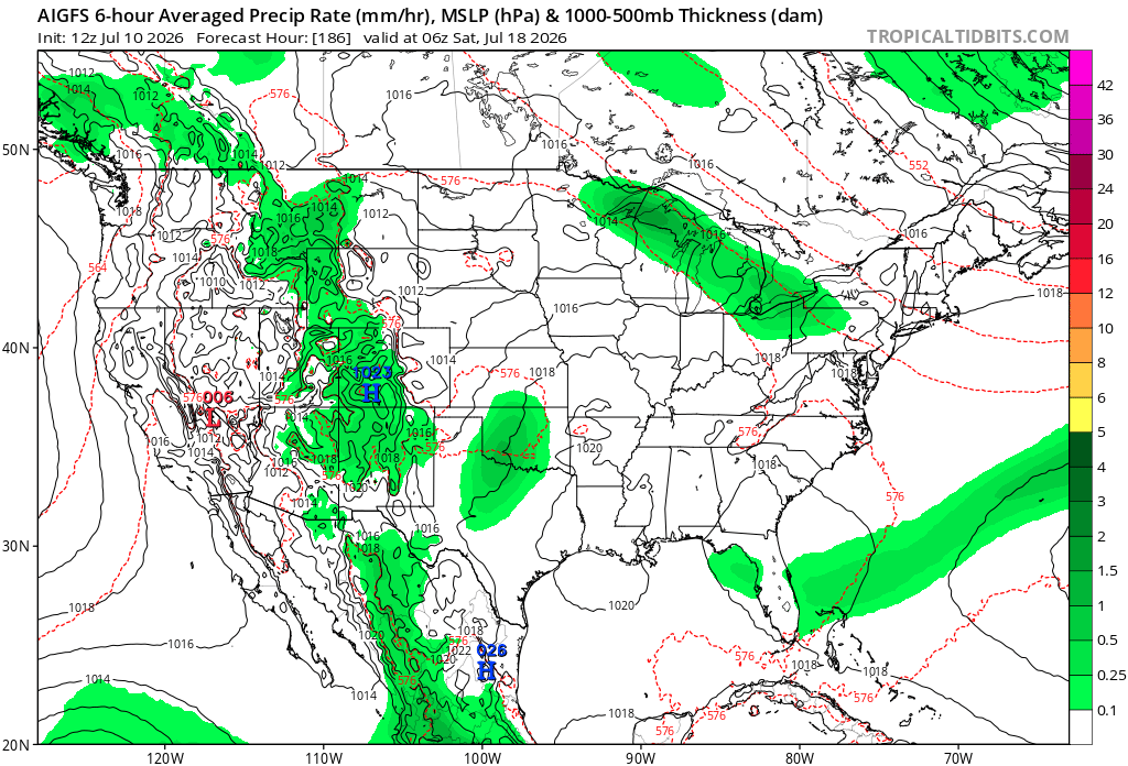
.thumb.gif.f92b16c631a1d15d405ed77b33f0710d.gif) west. there was nothing to track until the 18th onward
west. there was nothing to track until the 18th onward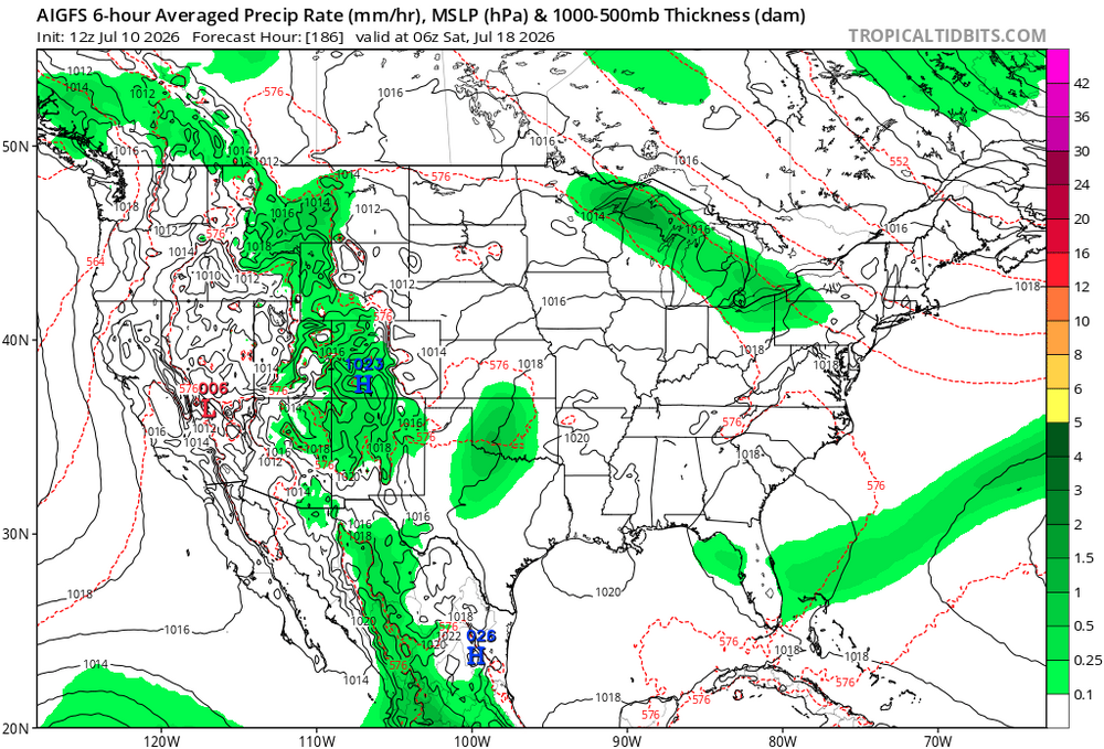
-

2026-2027 Super El Nino
snowman19 replied to Stormchaserchuck1's topic in Weather Forecasting and Discussion
We are already way ahead of all other El Niños on record in region 3.4. That aside, once this current WWB/DWKW and the 30C isotherm east of the dateline catches up and does their dirty work over the next month, Paul Roundy thinks this event surpasses 1997 in the far eastern ENSO regions next…subsurface and surface -
I meant long range
-
Wife is stressing. Planned a pool party for tomorrow. Weather looks better for Sunday. Told her "lets just move it to Sunday..?". "YOU CANT JUST MOVE PARTIES THE DAY BEFORE!". Guess I need to brush up on the party rulebook. Maybe I have an outdated version.
-
Training camp opens in 18 days. Summer is over!
-
July 10 2002: Intense rainfall causes extensive street flooding in St. Cloud. 2.70 inches of rain falls in 1 hour and 45 minutes at St. Cloud State University. People were stranded in their cars and had to be rescued by the fire department. For Friday, July 10, 2026 1913 - The mercury hit 134 degrees at Greenland Ranch in Death Valley, CA, the hottest reading of record for the North American continent. Sandstorm conditions accompanied the heat. The high the previous day was 129 degrees, following a morning low of 93 degrees. (David Ludlum) (The Weather Channel) 1926 - A lightning bolt struck an ammunition magazine in northern New Jersey, and a big red ball of fire leaped into the air triggering a series of explosions. All buildings within a half mile radius were destroyed, and debris fell as far as twenty-two miles away. Sixteen persons were killed, and property damage was seventy million dollars. (David Ludlum) 1936 - Afternoon highs of 112 degrees at Martinsburg, WV, 109 degrees at Cumberland, MD, and Frederick, MD, 110 degrees at Runyon, NJ, and 111 degrees at Phoenixville, PA, established all-time record highs for those four states. It was the hottest day of record for the Middle Atlantic Coast Region. (The Weather Channel) 1979 - The temperature at El Paso, TX, hit 112 degrees, an all-time record for that location. The next day was 110 degrees. (The Weather Channel) 1980 - The temperature in downtown Kansas City, MO, hit 109 degrees, following a sultry overnight low of 89 degrees. The daily low of 89 degrees was the warmest of record for Kansas City, and overall it was the hottest July day of record. It was the seventh of a record seventeen consecutive days of 100 degree heat, and the mean temperature for the month of 90.2 degrees was also an all-time record for Kansas City. 1987 - An early morning thunderstorm in Minnesota produced wind gusts to 91 mph at Waseca. Later that day, thunderstorms in South Dakota produced wind gusts to 81 mph at Ipswitch, and baseball size hail near Hayes and Capa. (The National Weather Summary) (Storm Data) 1988 - Thunderstorms brought welcome rains to parts of the central U.S., but produced severe weather along the New England coast, in the Great Lakes Region, in North Carolina, and in the Southern Plateau Region. Strong thunderstorm winds gusting to 80 mph at Bullfrog, UT, sank three boats on Lake Powell. (Storm Data) (The National Weather Summary) 1989 - Severe thunderstorms spawned seventeen tornadoes in the northeastern U.S. A powerful (F-4) tornado struck Hamden CT and New Haven, CT, causing 100 million dollars damage at Hamden, and another 20 million dollars damage around New Haven. Forty persons were injured in the tornado. Seventy persons were injured in a tornado which traveled from Watertown, CT, to Waterbury, CT, and another powerful (F-4) tornado touched down near Ames NY injuring twenty persons along its 43.5 mile track. It was the strongest tornado of record for eastern New York State. (Storm Data) (The National Weather Summary) 2005 - Hurricane Dennis landed near Pensacola, Florida as a category 3 storm. Maximum sustained winds at the time of landfall were near 120 mph. There were nine hurricane-related fatalities in the U.S. and preliminary estimates of insured losses ranged from $1 to $1.5 billion. Observances: 10 Fri National Kitten Day 10 Fri National Piña Colada Day 10 Fri National Pet Bedding Hygiene Awareness Day 10 Fri National Wyoming Day 10 Fri Pick Blueberries Day 10 Fri Political Flag Day 10 Fri Transplant Financial Coordinator Day 10 Fri Global Energy Independence Day
-
 more like way, way north
 -
yeah, forget it. any convection way way west
-
with the Central ridge being modeled more and more west, we may Stein for several weeks!
-
About to drink a 90 Min IPA
-
We are going to get skunked next week ughhhhhh
-
https://www.spc.noaa.gov/products/outlook/archive/2026/day1otlk_20260710_1300.html marginal risk issued for the majority of the state of tn just a 5% damaging wind risk for today day 1 https://www.spc.noaa.gov/products/outlook/archive/2026/day2otlk_20260710_0600.html for day 2 slight and marginal risk issued for tn with a cig 1 hatching 5-15% damaging wind risk https://www.spc.noaa.gov/products/outlook/archive/2026/day3otlk_20260710_0730.html day 3 has big marginal risk out for Tennessee with 5% probabilities
-
Anything for the hangover?
-
 What a great cool north wind. COC day at Pit2.
 -
the repair was a combo of crazy glue for skin and stiches
-
dry front about to slide through. Stein slider
-
 He’ll be on his 4th wife by Thanksgiving.
 -
Looked like we were finally going to get an actual sunny day, but here come the clouds again. Sigh.
(002).thumb.png.6e3d9d46bca5fe41aab7a74871dd8af8.png)