
All Activity
- Past hour
-
Ya we gotta be over 2” here…a big soaker for sure.
-
Temps evened out after the heat prior, imagine that. Some are too slow to understand. .15" additional rain, 1.80" total
-
(002).thumb.png.6e3d9d46bca5fe41aab7a74871dd8af8.png) But again the facts remain - either way we look at the data both raw and altered still shows a widening gap since 1970 - no reason to think that gap will not continue to widen.
But again the facts remain - either way we look at the data both raw and altered still shows a widening gap since 1970 - no reason to think that gap will not continue to widen.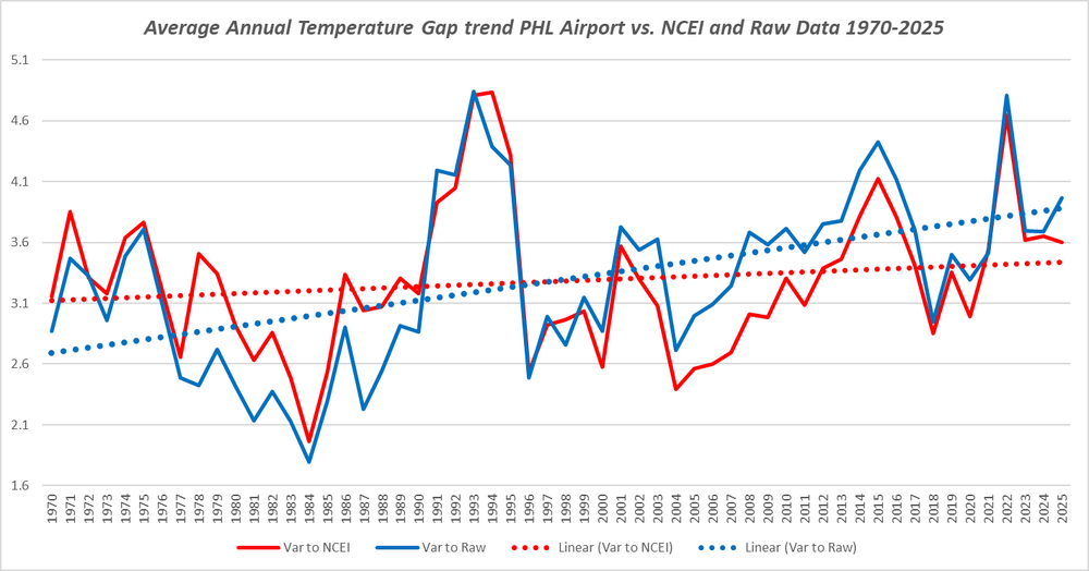
-
mm what stands out to me is that all these operational runs are wildly colder than their respective ensemble clusters at 850 mb by several degrees. Just a-priori on operational model guidance in meridian/slope flow types, they tend to carry an amplitude bias in the mid range to a significant correlation frequency. I'll concede if by hour 72 the means have deepened, otherwise for this type of synoptic hemisphere we've seen this kind of cold sell before.
-
Visiting my wife's sister near Liberty, NC. I do not envy you piedmonters your red clay. They are doing a lot of construction on their property and there is a ton of bare ground, which is currently a gelatinous quagmire.
-
Close to 3 inches here-what an awful holiday weekend at least we salvage this PM to some extent.
-
back edge coming through here finally-that dropped another .75
-

2026 Atlantic Hurricane Season
ineedsnow replied to Stormchaserchuck1's topic in Tropical Headquarters
11/4/2 -

2026-2027 Strong/Super El Nino
GaWx replied to Stormchaserchuck1's topic in Weather Forecasting and Discussion
More on the BoM warm bias: We remember how bad it was in 2023. But also: only 2 weeks ago, it had ~+1.15C for May (see image below) vs the latest’s only ~+0.55C in the image I posted in the previous post! It’s been doing this for 2 months and that’s the kind of thing it kept doing in 2023. We’re still likely headed for a super-Nino, but very likely not as warm as the RONI based ~+3.0C 3 month average super-super Nino the BoM is showing. It could easily be 0.5C too warm based on April/May and based on it being ~0.75 too warm around this point in 2023: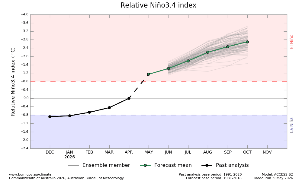
-

2026 Spring/Summer Mountain Thread
Maggie Valley Steve replied to Buckethead's topic in Southeastern States
Just emptied the rain gauge. 2.04 inches since last Wednesday night. -
Yes. They don't need to start completely over in terms of the players. That is why I think this can be turned around in a much shorter timeframe than before, and that another fire sale isn't necessary (not too many sellable veterans left anyway, lol).
-
What a deluge this morning. 49° R+
-
Saturday was dry until late day for most people. There in SW CT you were unlucky. This afternoon should slowly improve
-
2.37” in Syosset & raining currently.
-
Nino gonna Nino. I wouldn't say Summer cancel just yet, but if you're hoping for a pattern more accommodating to severe weather and persistent 80s/90s, it might be rough...
-
speak for yourself!! we snow!!!
-
I have hypothermia in the house this morning
-
Heck yeah!
-
2.02 total so far at my station
-

Central PA Spring 2026 Discussion/Obs Thread
Blizzard of 93 replied to Voyager's topic in Upstate New York/Pennsylvania
.22 rain today so far in Marysville. -
Beautiful weekend to me
-

Central PA Spring 2026 Discussion/Obs Thread
Voyager replied to Voyager's topic in Upstate New York/Pennsylvania
I want to try yard saling. What kind of boat should I get? -
The totals on the above map in Fallston of between 2 and 3 inches is right for the farm. We are probably around 2.4” with whatever has fallen this AM adding to it. That 3.5” over in Edgewood is reflective of the weird storm approach on Thursday to Fallston that fell apart and re-formed just past Fallston and unloaded on 95. SUPER glad for the last 60 hours of rain at the farm - hugely beneficial and hugely needed at a critical juncture as we’ve been getting flowers into the fields in the previous weeks…
-
Narrow band set up shop over head this morning bringing the total to 4.89" thus far. @MillvilleWx I've thought all along what an incredible snowstorm this would have been. Imagine our thunderous squall we experienced yet for several hours at a time. Yes, please and thank you I'll take another lol.
-
2026-2027 Strong/Super El Nino
GaWx replied to Stormchaserchuck1's topic in Weather Forecasting and Discussion
The latest weekly BoM, which just extended to Nov for the first time, is forecasting a +2.9C RONI in SON. The record back to 1950 is +2.5C (1982). However, caution on the ultimate strength is advised due to warm bias as it’s been significantly too warm in April and May: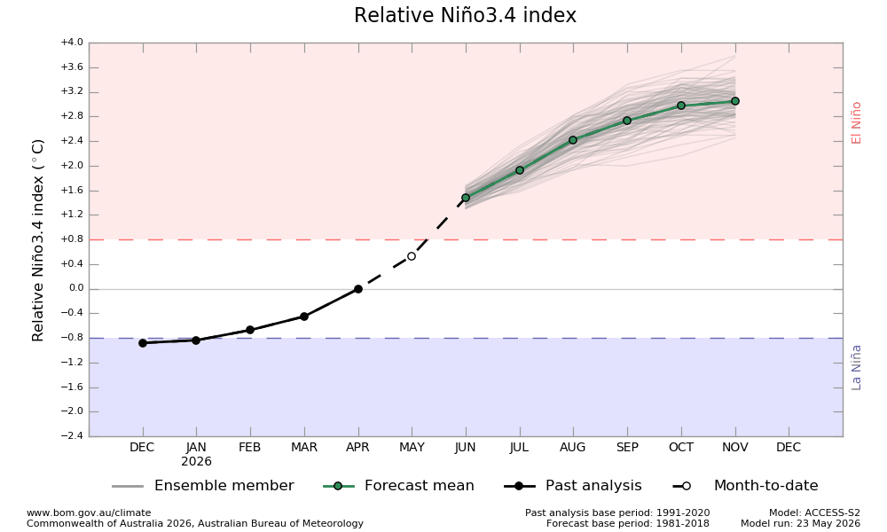




















.thumb.JPG.418e8a9a2902ae687ec35ff4bc0e038e.JPG)