All Activity
- Past hour
-

12/12: The little Friday clipper that could? Or won't.
Roger Smith replied to dailylurker's topic in Mid Atlantic
WHAT? __ trace of snow WHERE? __ on ground WHEN? __ later IMPACTS __ none, dog may sniff at it FUTURE __ bleak in Texas, get out while you still can -
I was figuring I should squeeze out 1-2" when I went to bed last night, but I think it'll be nothing now. As I posted after the debacle up here 2 weeks or so ago, without total model consensus this year, fugetaboutit. I guess there's still time, but the flavor of this season for snow has gone sour and there's nothing on any modeling to suggest otherwise for weeks to come.
-
6z nam south too.
-
It was also quite mild up north here, near 50 F in the Columbia valley (Trail BC) where there is no snow at all, and 45F at my elevation where we still have a bit of snow cover, mostly frozen slush at this point. Driving down the hill into Trail it was evident that the snow line was just below 3,000' asl here. (at the border the valley is down around 1500' asl). It was almost jacket-free mild in the valley and you do see the odd person wearing shorts even in this ski resort area (making a statement of some kind, no doubt). A minor renewal of the major 2021 Fraser valley flood disaster is underway. The Nooksack River which drains the Mount Baker region into Puget Sound had a natural outflow channel before modern times through a flat area near Abbotsford BC known as the Sumas Prairie. There was a natural lake that was drained for intensive agriculture, and of course in very wet seasons that lake tries to fill up, and largely succeeded in Nov 2021. At this point, some water 2 or 3 feet deep has crossed the border, mostly overflow from the Nooksack although there are some tributaries of the Fraser that flood also. There is some infrastructure to channel these overflows into drainage canals that are then pumped over a low divide into the Fraser. In Nov 2021 the Fraser was also flooding so this failed leading to a very rapid inundation to a level of 10-15 feet in some areas. This potential has been known for decades and you would think massive infrastructure would have been built to deal with it, but for whatever reason we are stuck with the rather ineffective smaller scale plans that only work in moderately wet weather conditions. This is because our BC provincial politics seem to be based on a combination of salmon worship and endless talk about possible plans but not starting any of them for fear of offending the spirit of the wild bear. At least that's how it was explained to me at the Indoctrination Center.
-

December 2025 regional war/obs/disco thread
moneypitmike replied to Torch Tiger's topic in New England
Even on a system like this, the new Pit manages to have rain mentioned in the forecast Saturday Night A slight chance of rain before 8pm, then snow. Low around 26. West wind around 6 mph becoming calm after midnight. Chance of precipitation is 90%. New snow accumulation of less than one inch possible. Sunday Snow, mainly before 2pm. High near 34. Light north wind increasing to 5 to 10 mph in the morning. Winds could gust as high as 23 mph. Chance of precipitation is 80%. New snow accumulation of 1 to 3 inches possible. -
Tick south. It’s funny. Looping the trend over the last 24-36hrs it ticks south at 00/12 and north at 06/18. If you’re still an offhour conspiracy theorist there ya go.
-
GFS still has no budged in like the last 10 runs.
-
Not 3k
-

December 11th-14th Double Banger Clippers
KeenerWx replied to Jackstraw's topic in Lakes/Ohio Valley
0.3” call busted high on this current piece, but at least the flakes flew I suppose. For the second piece just gonna throw copium and see what we get. -
Named!
- Today
-
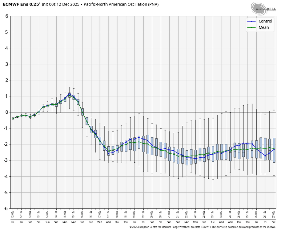
Will be watching the PNA the next couple of weeks to see how long our warmup lasts starting later next week. As long as PNA stays near -3 standard deviation then it is very hard for it to be cold enough to snow at our latitude no matter what the other signals show.
-
Brace yourselves... Let's at least get some Foxboro snow mojo in the air Sunday
-
Maybe the "boo-birds" will be throwing snow balls, not hot water, on Sunday.
-
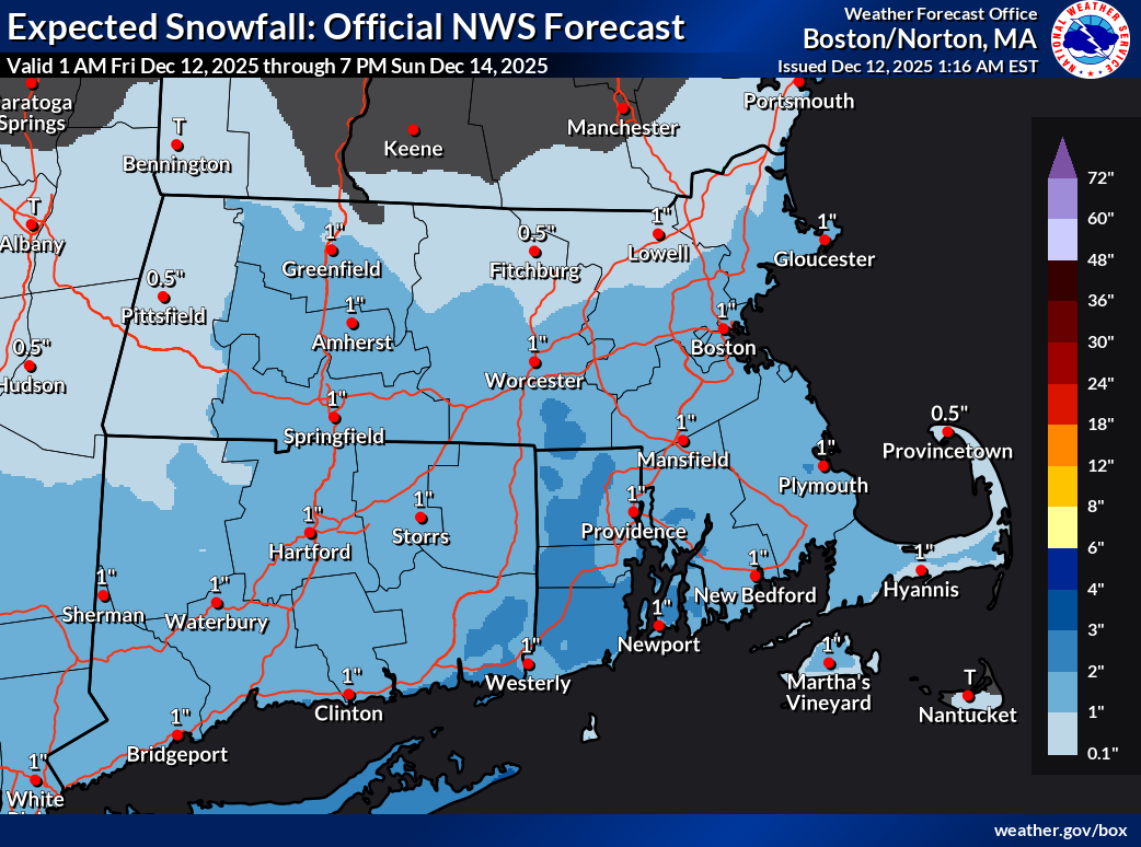
18z NAM was an example... on that run, more energy was able to compensate a little for the worse tilt and southeast squash To echo what CoastalWx and others have said... I remember the occasions, felt like a few times every season, when we were micro-analyzing such details with huge stakes on the eve of classic KUs. Now the stakes are a few inches and it's tiring. 0z Euro continued to tick the trough more positive and outcome more southeast... maybe 1-3" south coast, 3-4" outer Cape. 0z AIFS a hair better.
-

Minor snow possible sunday 12/14/25
coastalplainsnowman replied to WeatherGeek2025's topic in New York City Metro
There seems to be a hard cap of about 35% happiness here. -

December 2025 regional war/obs/disco thread
Snowcrazed71 replied to Torch Tiger's topic in New England
Isn't the euro out soon? -

Minor snow possible sunday 12/14/25
RU848789 replied to WeatherGeek2025's topic in New York City Metro
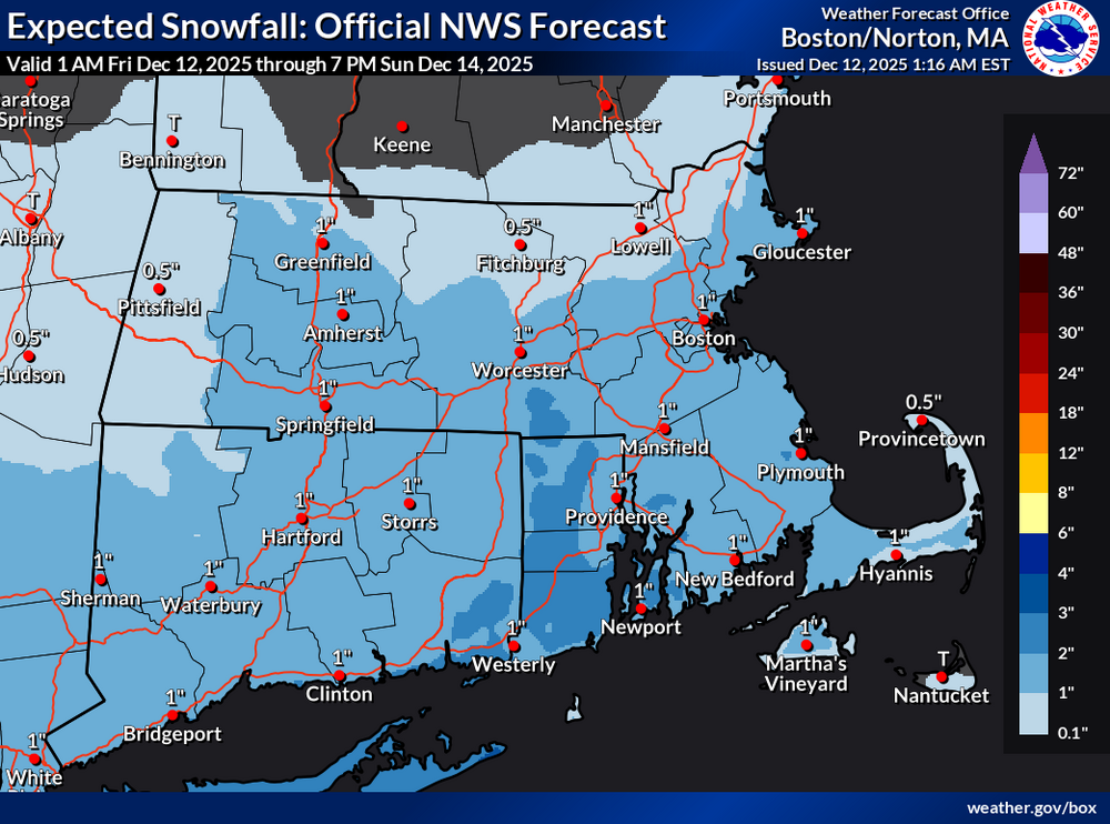
My point was that they could've issued a 72-hour map (that's as far out as they issue them, which I'm fine with) at 18Z that went through 18Z Sunday, which is past the end of the storm, but they waited until 0Z to do so. Plus, I think issuing a map through only 12Z Sunday, without clearly noting that snow wasn't over yet is more than a little misleading and something they shouldn't do, IMO. -
.thumb.png.4150b06c63a21f61052e47a612bf1818.png)
December 2025 regional war/obs/disco thread
HIPPYVALLEY replied to Torch Tiger's topic in New England
Lets do it! -

December 11th - 12th clipper potential
John1122 replied to Holston_River_Rambler's topic in Tennessee Valley
Looks like I'm gonna finish up at about 1.5 inches. Shocked by this one. -
Sticking with the NBM on this one. Expectations should be 1-3 for many east of 15 with perhaps a 4” lolli where things line up just right - looking to likely be NE of Baltimore, my guess is somewhere near elk neck state park along the bay
-

December 2025 regional war/obs/disco thread
weathafella replied to Torch Tiger's topic in New England
lol…skynet with the Christmas Eve sizable snowstorm. -
December 2025 regional war/obs/disco thread
HIPPYVALLEY replied to Torch Tiger's topic in New England
Brisk night. 20F with a fresh breeze and some good gusts. I'll probably go test/measure the ice on a local lake on Sunday. Should be several inches of black ice by then. -

December 11th-14th Double Banger Clippers
Radtechwxman replied to Jackstraw's topic in Lakes/Ohio Valley
Im definitely worried about another south trend. 0z euro and 0z nam's still look solid for you. Gfs was the most south. Hrrr/rap decently north as well but they also were night before this current event. -
December 2025 regional war/obs/disco thread
HIPPYVALLEY replied to Torch Tiger's topic in New England
Still looks like a few inches of fluff is possible for the S Coasts and the Cape. Parts of CT/RI too. -

12/14: Sunday funday? Will the south win again?
Maestrobjwa replied to TSSN+'s topic in Mid Atlantic
Seems like a step toward the GFS though...although precip distribution looks different.