All Activity
- Past hour
-
For research purposes, NCEP/NCAR was eclipsed a long time ago by ERA5 (Euro-based, of course). It is all available, but I'm not sure if there are any sites that make it easy to use for the public.
-
Illinois is gonna manifest 11/17/13 2.0 with the kinda year we've been having
-

2026-2027 Record-breaking El Nino
michsnowfreak replied to Stormchaserchuck1's topic in Weather Forecasting and Discussion
I hate when the media does that. Especially for areas such as the Great Lakes, Midwest and Northeast. Its actually fascinating to see how much of the world does NOT get to enjoy the extremes of both winter and summer like we do. Really if you like seasonal extremes, its a great place to live. Our griping, complaining, worrying or excitement based on what local weather lies ahead is our personal comparison to our climo that were used to. I have a friend in the UK and she would freak at how cold she would be in our warmest winter on record or how hot shed be in our coldest summer on record. -
Getting all you snow in 24 hours and have it melt off in two days would be heart breaking.
-
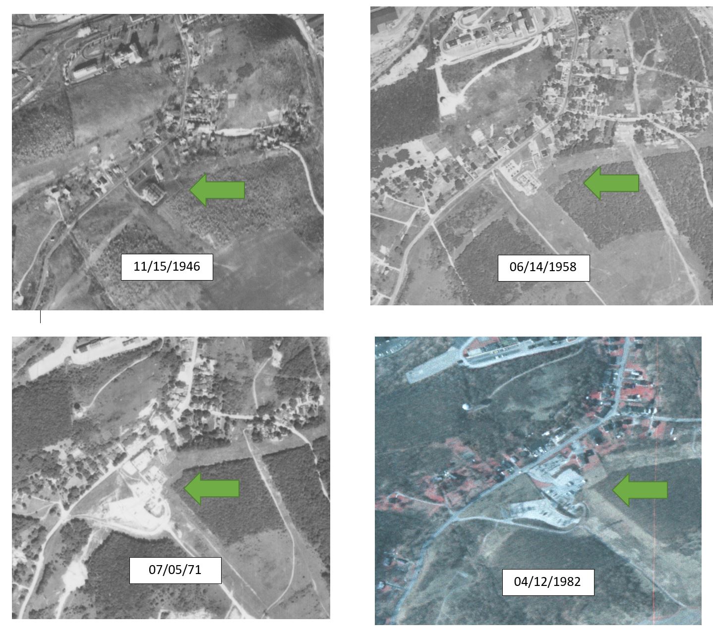
 The Coatesville graphic I supplied says that in the period of 1952 to 1982 there was extensive construction going on at this station location. its an electrical substation with megawatts of power going through it. As components move, there will be step wise changes--up or down. The station itself could be moving also as office space changes. Here are the images showing that station and ongoing construction. Once again, we have 100% documented evidence of microsite impacts to a station record, and a) adjustments are valid and b) absolutely necessary. Both a and b are within the context of using weather station data to develop climate information from multiple stations.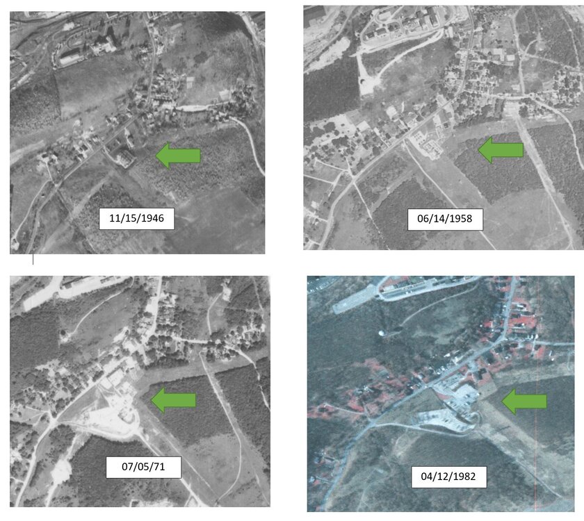
-
Yep. We have November which I kind of think as our second tornado season compared to Spring early Summer.
-
After a decent low of 70, we soared all the way to 97 today.
-
2026-2027 Record-breaking El Nino
michsnowfreak replied to Stormchaserchuck1's topic in Weather Forecasting and Discussion
I hate that too. I hate heat but if its going to be hot id much rather see a good heatwave challenge some daytime high records rather than a swampy 88-92 with warm tropical low temps bringing up the departure. -
Appreciate the reports from a real head, glad you're all good
-
I hope this rain is done for awhile, we can't take anymore. I am very familiar with the creeks and rivers around here as I do a lot of fishing, canoeing and kayaking especially East of State Road 9. I took a ride around Madison, Delaware and Hancock counties today and there are places I've never seen the water that high ever (in 15 years anyway). They are saying record levels on the White River from around Muncie to Anderson. There is a big gravel pit, about 100 acres, to my SE on St Rd 13 that the gravel tower that loads the trucks is halfway under water from the table rising in the 3 pits its already dug. That thing is 75ft tall. Bridges along Pipe creek and White river are like 12 inches from going under on major roads and highways. These are fairly large spans (for us in the stix lol) of over 100ft. Tons of roads closed and EMS trucks and cars everywhere. Believe it or not I forgot my phone lol. I'm gonna go back around tomorrow as the rivers are supposed to crest then and get some pics. Its pretty bad. I know the New Castle and Cambridge areas got hammered too but thats a bit of a stretch for me just farting around lol. That was a ton of rain in such a short time for about an 8 county area.
-

2026-2027 Record-breaking El Nino
40/70 Benchmark replied to Stormchaserchuck1's topic in Weather Forecasting and Discussion
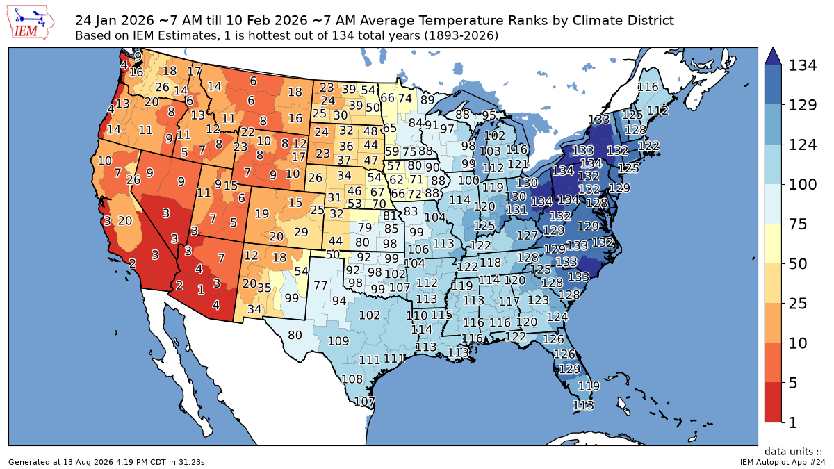
I expected a bitter stretch in latter January into early February in association with that +TNH pattern, but it was cold more consistently than I expected. -
Its possible, but the least likely outcome as psuhoffman says. It happened in 23-24 when that nino didn’t fully couple. This time it’s going to be even stronger and the PDO is rising, should be a well coupled event.
-
Hail and urban flooding for some areas around Denver
-
Maybe something in the middle is possible? With a bit of luck and timing, why not a couple light to moderate events and a big coastal storm? I don't think it has to be binary. We are in uncharted waters to an extent, so who really knows? (no one)
-
That was in the list for 2009-10. The one I am referring to is missing. https://www.raymondcmartinjr.com/weather/
-
There’ll be two camps. Some will go warm and snowless, and others will call for at least one HECS event. Toss up, but I may go the former and then later root against my own forecast.
-
Afraid to jinx this, but in addition to fewer cicadas this year, I feel I can confidently say fewer laternflies as well. Especially at work in Greenbelt. Last year they just covered the front of the building on warm days. Only even seen a couple this year there.
-

Augdewst 2026: Summer's Last Stand
Ginx snewx replied to Prismshine Productions's topic in New England
Getting crushed in Danielson -
Jan 30th 2010. 5-8" storm with some locally higher amounts- more east/south including SNJ(Ray's area). Important because we hadn't had any snow since the pre Xmas Dec blizzard, Ji was was about to have a grand mal meltdown; it was a cold powder smoke job with temps in the teens; it looked like a miss south a couple days prior, and it set the stage for what was to become probably the most epic 10 day period of snow we have seen in our lifetimes. https://www.weather.gov/media/phi/StormReports/January302010.pdf
-
(002).thumb.png.6e3d9d46bca5fe41aab7a74871dd8af8.png) What remains genuinely open regarding Coatesville 1SW remains the magnitudes have never been independently checked. A documented 0.3-mile move does not actually tell us the offset should be +0.86 °C. That number comes from neighbor comparison, not from the site. Nobody in this thread has tested whether the applied steps match what the physical changes would produce. Also of note about a third of the adjustment trend attaches to no listed changepoint at all. +0.123 reconstructed against +0.184 actual. No station history can validate a component that no documented event is claimed to explain, and NCEI hasn't yet answered that from my earlier email. Lastly, and what can't be overlooked is that the raw cooling doesn't behave the way the artifact explanation predicts. Fitting the breaks actually deepens it rather than dissolving it!!
What remains genuinely open regarding Coatesville 1SW remains the magnitudes have never been independently checked. A documented 0.3-mile move does not actually tell us the offset should be +0.86 °C. That number comes from neighbor comparison, not from the site. Nobody in this thread has tested whether the applied steps match what the physical changes would produce. Also of note about a third of the adjustment trend attaches to no listed changepoint at all. +0.123 reconstructed against +0.184 actual. No station history can validate a component that no documented event is claimed to explain, and NCEI hasn't yet answered that from my earlier email. Lastly, and what can't be overlooked is that the raw cooling doesn't behave the way the artifact explanation predicts. Fitting the breaks actually deepens it rather than dissolving it!! -

2026-2027 Record-breaking El Nino
roardog replied to Stormchaserchuck1's topic in Weather Forecasting and Discussion
The media will have you believe that every heatwave is a “heat dome” that will melt your entire body and you’ll end up in the city sewer system. Meanwhile every cold snap is the polar vortex coming south instantly freezing every human or animal outside in place. In reality, sometimes it’s just really cold in winter and really hot in summer. - Today
-

2026-2027 Record-breaking El Nino
bluewave replied to Stormchaserchuck1's topic in Weather Forecasting and Discussion
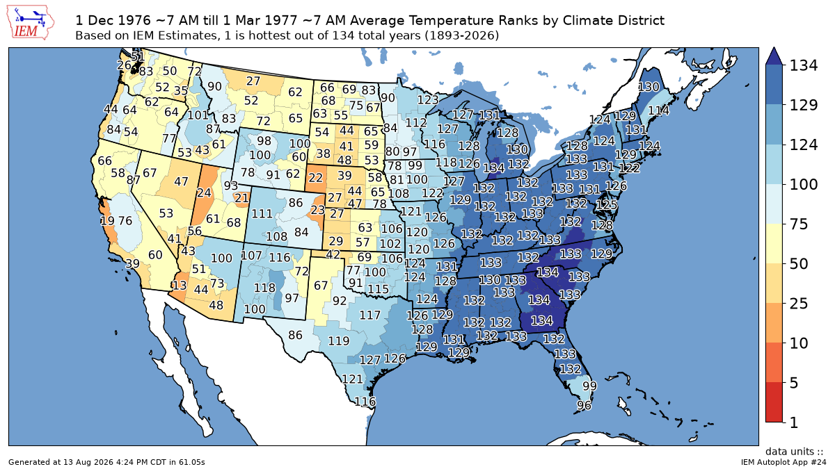
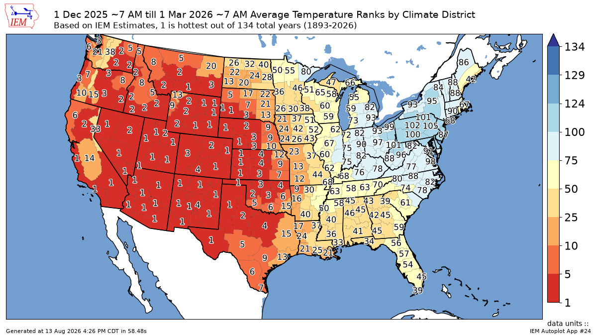
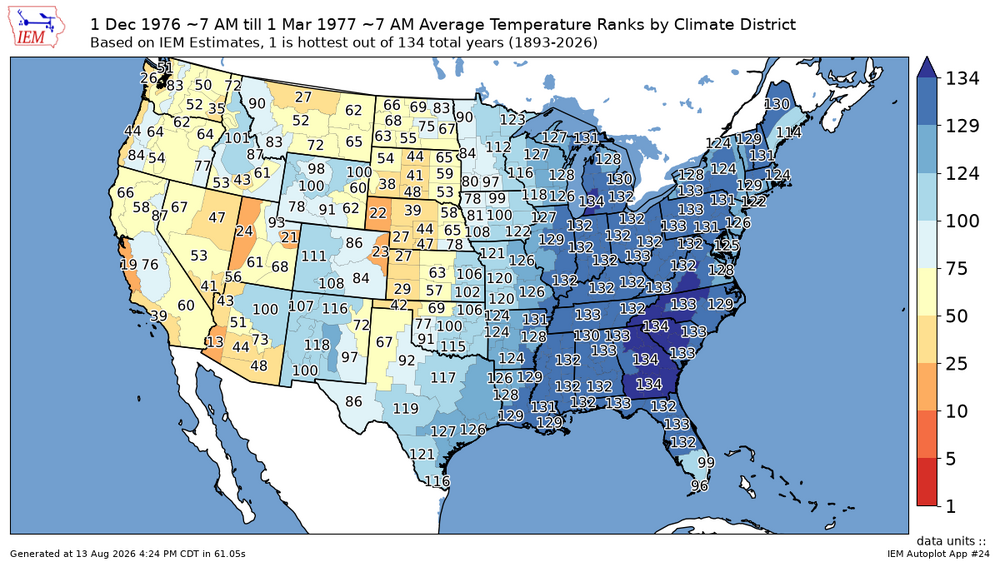
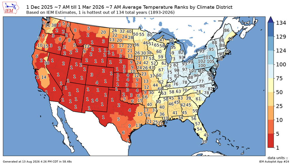
We got that impressive 16 day run of cold from late January into early February. But since the rest of the U.S and the Northern Hemisphere was so warm last winter, the duration of the noteworthy cold was limited. Back in the late 1970s when the world was much colder, there was ample cold supply across the Northern Hemisphere for the entire winter to rank as cold as the 16 day period did last winter. So the Northeast had to wait 11 years to finally get a colder winter than the long term average.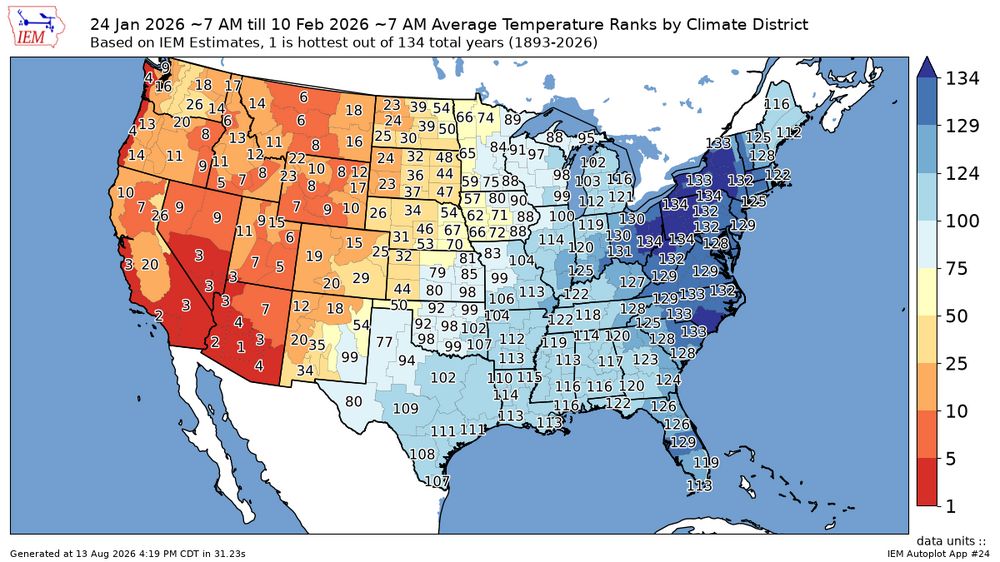
-
3rd straight 88° high temp. Been a warm month so far with a +3.2° departure.
-
Whats with the constant smoke every day? Is the new normal?
-
Could be December 2009. That was a big one that got overshadowed by February 2010.