All Activity
- Past hour
-

October Comes Early: Late September Multi-Hazard Hybrid Storm
Lava Rock replied to WxWatcher007's topic in New England
Parents try to sue the school? Sent from my SM-S921U using Tapatalk -

2026 Atlantic Hurricane Season
WxWatcher007 replied to Stormchaserchuck1's topic in Tropical Headquarters
I’d appreciate, rather my peak season forecast would appreciate, another run at hurricane status -

Strong Nor'Easter/Hybrid Storm Late September 2026
mob1 replied to Rjay's topic in New York City Metro
While the HRRR is notoriously too amped and NW at this range, it's too far off of what the 0Z Euro had (though it's far tamer in its latest run) and if other models come in that tucked to the coast I could see this being a more significant wind event than what's currently expected.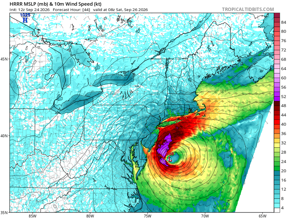
-

Strong Nor'Easter/Hybrid Storm Late September 2026
Neblizzard replied to Rjay's topic in New York City Metro
Should know more after the 12z suite. -
6z euro AI has the 0.5” rain contour back to Baltimore and MBY this weekend from the nor’easter.
-

Septorcher 2026 Discussion - Endless Summer
weatherwiz replied to Damage In Tolland's topic in New England
Noticed a pretty significant increase in tree color with the tree out front and neighbors yard from a few days ago. -

Strong Nor'Easter/Hybrid Storm Late September 2026
Brian5671 replied to Rjay's topic in New York City Metro
I think the impacts at some of the beaches will be pretty bad-days of onshore flow pushing water in before the main event and full moon Saturday to boot. -
Decided October feel out there this morning. Overnight low of 44 with a gusty NE wind. Seems Summer has fallen off the cliff.
-

October Comes Early: Late September Multi-Hazard Hybrid Storm
powderfreak replied to WxWatcher007's topic in New England
That poor kid last year that had the tree kill him while on the physical playground at school outside Boston during a windy day… that stuff is why. -
So surprised this is not even getting mentioned in the TWO. Wonder what the internal reasoning is?
-

Strong Nor'Easter/Hybrid Storm Late September 2026
NEG NAO replied to Rjay's topic in New York City Metro
You should break down the areas that will get a few inches - the areas that will get a few showers only and the areas that will get more than a few inches Some areas to the east will have trees falling with significant flooding this is not a uniform event there will be a wide range of outcomes. -

E PA/NJ/DE Autumn 2026 Obs/Discussion
JTA66 replied to PhiEaglesfan712's topic in Philadelphia Region
Yeah, I've been thinking all week how much "fun" this would be to track if it were winter. Buckle up! 54F/DP 46F -

October Comes Early: Late September Multi-Hazard Hybrid Storm
WinterWolf replied to WxWatcher007's topic in New England
Lawsuits…that’s why. God forbid if a bus load of kids has a tree branch fall on the bus. So that’s why. Whatever. Back to the potential storm. -
October Comes Early: Late September Multi-Hazard Hybrid Storm
Brian5671 replied to WxWatcher007's topic in New England
I'm sure if it were a weekday-we'd have school closures for wind and rain. in NEW ENGLAND nonetheless -

Strong Nor'Easter/Hybrid Storm Late September 2026
TriPol replied to Rjay's topic in New York City Metro
It's going to be a Nor'Easter. We'll get a few inches of rain we don't need right now. Trees will fall. Roads will flood. We'll live! Then, next week, we'll be in the 70s. I'm semi-looking forward to that before it starts getting to sweater weather. -

Septorcher 2026 Discussion - Endless Summer
Brewbeer replied to Damage In Tolland's topic in New England
torch ! 54/47 with an unusually stiff breeze from the northeast -

October Comes Early: Late September Multi-Hazard Hybrid Storm
Typhoon Tip replied to WxWatcher007's topic in New England
Not meaning to digress the thread but all of humanity appears to be swooning over and guided by the 'grand presentation' these days. It's like we're all participating unwittingly in a dystopian cinema - if not delusion. It's a movie about the evolutionary scaled, socio-technological experiment we're sending our own species through. -

Strong Nor'Easter/Hybrid Storm Late September 2026
donsutherland1 replied to Rjay's topic in New York City Metro
IMO, the probability of a more significant impact in the NYC area has increased overnight. The uncertainty is lessening. -

Strong Nor'Easter/Hybrid Storm Late September 2026
Tatamy replied to Rjay's topic in New York City Metro
If they name it the next name is Gonzalo -

E PA/NJ/DE Autumn 2026 Obs/Discussion
The Iceman replied to PhiEaglesfan712's topic in Philadelphia Region
It is actually insane the amount of model spread we have 48 hours out. Euro/euro AI continues to give most of the area a legit northeaster, GFS/CMC continue to be a glancing blow. ICON/`NAM have moved in the EURO camp. The RGEM is in the GFS/CMC camp. If this was snow, people would be losing their minds lol -
 get medicine instantly: Gen Indus Pharma - pharmacy website
 -

October Comes Early: Late September Multi-Hazard Hybrid Storm
Great Snow 1717 replied to WxWatcher007's topic in New England
How soft has society become you ask???...so soft that some girls volleyball matches scheduled for Saturday have been postponed. .last time I checked volleyball is played INDOORS.. -
Down to 46 for a low. Great way to start autumn.
-
October Comes Early: Late September Multi-Hazard Hybrid Storm
Typhoon Tip replied to WxWatcher007's topic in New England
Agree. And the Euro ... described below. As far as the GFS ...the difference seems to be that it doesn't include a tropical source. It is more purely cooler thermodynamic/baroclinic, and as such a weaker total cyclonic recovery takes place when this ...weirdness closes off. In and of itself I suspect it is too strong ? Not certain on that; just a-priori on modeling tending to bias on the strong side with everything at this range ...only to Charlie Brown the top 10, 20 ...30% off results at go time... I think there's wiggle room in this scenario as far as amplitude results. The Euro on the other hand, heh. It pretty clearly indicates what it "thinks" is a kind of 'zygote' tropical entity straddling or just barotropic sidled to the frontalysis boundary, which it is extending between the Carolinas and mid way to Bermuda over these next 48 hours. WPC currently analyzes a stationary boundary with low on it, however. Still, it first appears more tropical in the phase space nearing 988 mb as it moves W toward the VA Capes lat (off shore).. Then drifts NNE toward the Benchmark, losing those characteristics in a less hospitable environment, before undergoing some sort of delayed baroclinic inject, it then re-deepens to 984 or so as it retrogrades back W along or S of LI.. Helluva sell for meticulous skill - I find that overall evolution either extraordinary, or ... unlikely to be so well handled and accurate by the Euro so precisely. We'll see. It's interesting... All of it I suspect is more open to uncertainty than many are likely aware. Just higher than normal for this range. -

Strong Nor'Easter/Hybrid Storm Late September 2026
GaWx replied to Rjay's topic in New York City Metro
Then the NHC should be adding it to its TWOs since those address the chance for both T and ST development. Adding it to its TWOs has been suggested by both JB and @vortex95