All Activity
- Past hour
-
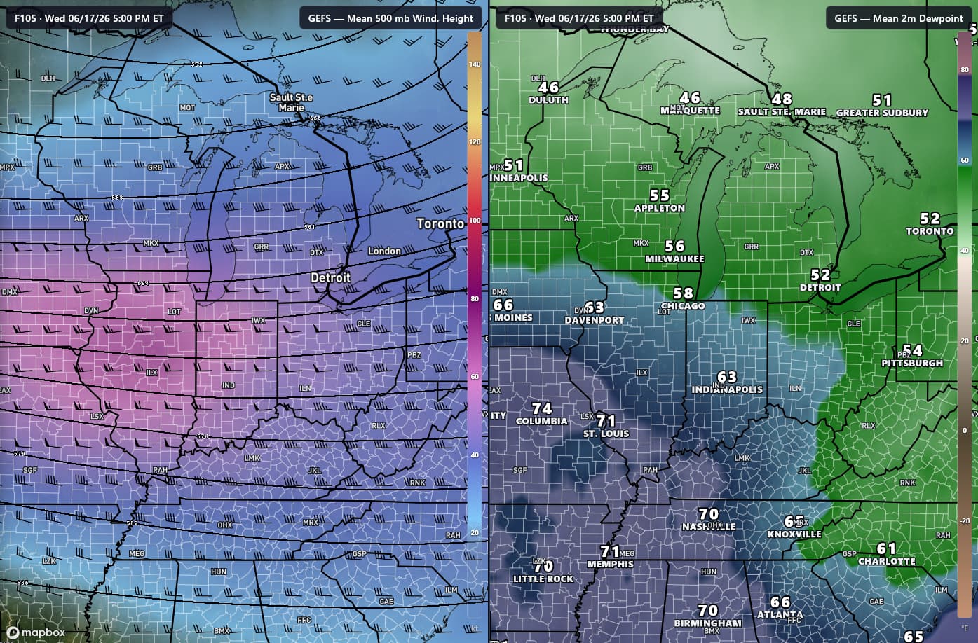
Looking like another impactful stretch of weather coming up, with Wednesday, as of now, having the highest ceiling. StormNet, CSU-MLP, and other ML products have all had very "hot" runs lately, pretty eyecatching stuff, especially as the northern bound of the highest prob area is over the same area that saw several tornadoes on Thursday. The GEFS has been consistent in showing an area of high P[SCP>1] over portions of Missouri and Illinois, even back into Kansas, for multiple runs now, while other models expand the risk further east towards Ohio. Regardless, very strong flow for this time of the year will overlap an area of ample moisture. Should be an interesting couple days.

-
God I hope ur right bro!!!
-
Apparently, not humid enough for some.
-
Agreed, it looks like another potentially widespread and significant severe weather episode with very strong flow overlapping high moisture. Tuesday could have some potential too.
-
Short range models whiiffed,better convection was seemingly in SW Tn,but nothing really severe
-
Ugh! No fun! That had to be miserable for her on Friday! As I get older my excitement for severe weather is drastically waning! I only root for snowstorms now!
-

2026-2027 Super El Nino
Maestrobjwa replied to Stormchaserchuck1's topic in Weather Forecasting and Discussion
Sheesh...what do we have to wait another decade to get outta this? Boo, lol -
Well I don't mind the drought because I don't have to cut an acre of lawn every week. But I do miss the rain cause the grass is looking more brown then green
-
I had some minor branches go in ng across. The driveway but other than that, the storm were more bark then bite. Barely any rain
-
Much less hot today we haven’t broken 94 yet. Mostly overcast and not as humid
-

2026-2027 Super El Nino
GaWx replied to Stormchaserchuck1's topic in Weather Forecasting and Discussion
Yes, ncep ~-0.75 to -1 vs WCS -
So much for rain today too...rain will stay south...screwed again
- Today
-
Decent
-

2026-2027 Super El Nino
mitchnick replied to Stormchaserchuck1's topic in Weather Forecasting and Discussion
It was last year at this time when the PDO started its dump. Interesting to see if we repeat. I know Larry uses Ncep(?) numbers, but I think they pretty much followed the same trend as this graph. Feel fee to correct me Larry..png.67e6bcdc658f4999de7a247c3e83f69a.png)
-
Sorry for the late reply. Sadly I missed out on the seeing the storm hit due to other reasons but could hear it. Family reported that we had a huge wind gust and lost power because of it. Was out for about 2.5 hours. Kids saw a sweet rainbow and sunset sky after that was awesome. Speaking of trees, my mom's hood in annandale was smacked from the storms on Thursday. A huge 30" poplar fell across the road taking out power lines. That was 8pm thursday. Dominion didn't show up until yesterday afternoon so a full 18 hours later. They worked on things but the storms last night knocked power out for a larger area surrounding my mom's house. She didn't get power back until 2am. So a full 30 hours w/o power for an 85 year old and no a/c. And dominion wants to merge to make more money.
-
Gorgeous day
-
Hit 100 again today.
-
What a day
-
79/55 But that peak June sun feels much warmer to me. I would’ve guessed mid-80s working outside.
-
Yes new moon tomorrow.
-
Exactly. Like I said, no one ever fixes it. It is what it is at this point. Temps off, cant measure snow, etc.
-
Surprised there’s no red flag warnings in Franklin County with this breeze. it is dry and crunchy.
-
2PM vs 24 hrs ago: RDU 7 cooler, more clouds, and NW vs SW winds
-
There’s a coastal flood statement posted in my area… Astronomical high tides? The statement doesn’t mention the potential cause.
-
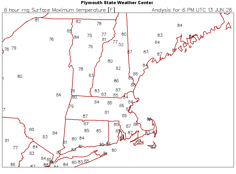
Up to 86F, slightly humid. A trace is of rain so far this week so lawn is pretty crispy
.thumb.jpg.ad3a2e31d30aff035044689b311a0540.jpg)


.thumb.gif.f92b16c631a1d15d405ed77b33f0710d.gif)


