All Activity
- Past hour
-
0.06" here. The guidance has varied so widely for my location I have no idea how much more I'm going to get. Could be nada or could be a couple of inches. RAH has me in the 1 - 1.5" zone which would be much appreciated. Based on persistence the lower end is definitely in play.
-
Last night was awful. Bad pain and no sleep.
-

2026-2027 Record-breaking El Nino
40/70 Benchmark replied to Stormchaserchuck1's topic in Weather Forecasting and Discussion
@LibertyBellhas the record for most quotes in one response. -

2026-2027 Fall/Winter Mountain Thread
Maggie Valley Steve replied to BlueRidgeFolklore's topic in Southeastern States
Just started pouring here with gusty winds. -
Regardless of strength (I’ve seen Andrew & Michael up close). Unless you have boots on the ground you don’t realize the amount of damage even a storm of this strength can cause. My thoughts are with the many people who are dealing with issues big or small. I can tell you the Emerald Coast got smacked by this. Glass half full thoughts, are the shear and dry air saved us from what could’ve been a monster! .
-
You are viewing a monthly mean, which is important considering any potential pattern change around that time...but I see some decent ridging out west.
-
 before and after semaglutide: SemaOral Direct - how long does compounded semaglutide last in the fridge
 -
Due to the pressure gradient between Isaias’ remnants and the wedge, along with sig. ongoing rain, together with a secondary astronomical tidal max due to the new moon, the NE winds were long and strong enough to produce moderate coastal flooding in CHS and minor S of there to Ft. Pulaski. 0842 AM COASTAL FLOOD 1 E CHARLESTON 32.78N 79.93W 10/10/2026 CHARLESTON SC OTHER FEDERAL A MAXIMUM TIDE LEVEL OF 7.76 FT MLLW (2.00 FT MHHW) WAS OBSERVED AT THE CHARLESTON HARBOR TIDE GAGE. MODERATE COASTAL FLOODING TYPICALLY BEGINS ALONG THE COASTS OF CHARLESTON AND COLLETON COUNTIES WHEN TIDE LEVELS REACH 7.5 FT MLLW (1.74 FT MHHW) IN THE CHARLESTON HARBOR.
-
from 4-6 inches in on the NAM To .50-.75 on the GFS LOL
-

2026-2027 Fall/Winter Mountain Thread
franklin NCwx replied to BlueRidgeFolklore's topic in Southeastern States
Been pouring for the past hr and wind is ripping! -
That what happens when I live on the north side of the mountain in a valley beside the creek.
-
In my area overnight, we got some beneficial rainfall from rapidly N moving scattered convection. Per Cocorahs, there was ~0.75” in the area. I’ll check my gauge later. Winds were brisk but no big deal as expected (highest gusts low 20s). Sun is peaking through. The sun will eventually lead to sig. instability, which will fuel scattered or bands of tstorms this afternoon, some of which could be severe with a couple of tornadoes possible.
-
Most models show some strengthening of the storm as it approaches our area
-
N Gulf hurricanes that come this way sometimes “wake back up” over our area like Ida which caused more deaths here than anywhere but this won’t be one of them. You can already see it’s sheared apart and won’t be a very coherent system here. Probably a general 1-2” rain like most models are showing.
-
https://www.espn.com/nfl/story/_/id/50147669/sources-ravens-held-cam-jurgens-physical-trade-eagles Expected to play next week, not this Sunday
-
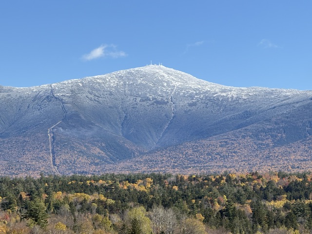
Foliage is going fast but the views are still pretty
-
Yeah so ridiculous. Other models like RGEM, HRRR and GFS have our area closer to 1 inch.
-
legal online pharmacies in the us and safe online pharmacies online pharmacy http://www.dot-blank.com/feed2js/feed2js.php?src=https://queticarerx.com no rx needed pharmacy and https://www.0468wudi.com/home.php?mod=space&uid=310328 safe online pharmacies [url=http://www.tvtix.com/frame.php?url=http://queticarerx.com]online pharmacy no prescription[/url] online pharmacy without prescription and [url=http://www.1gmoli.com/home.php?mod=space&uid=1170712]worldwide pharmacy online[/url] top online pharmacy
- Today
-
41 here for the low. It uncanny how many times you are two degrees colder than I am. More times actually than I've posted.
-
Looks like the NW side has become the wettest side.
-
That band will have to overperform later for us to get the big totals. I'm only at .54 so far.
-
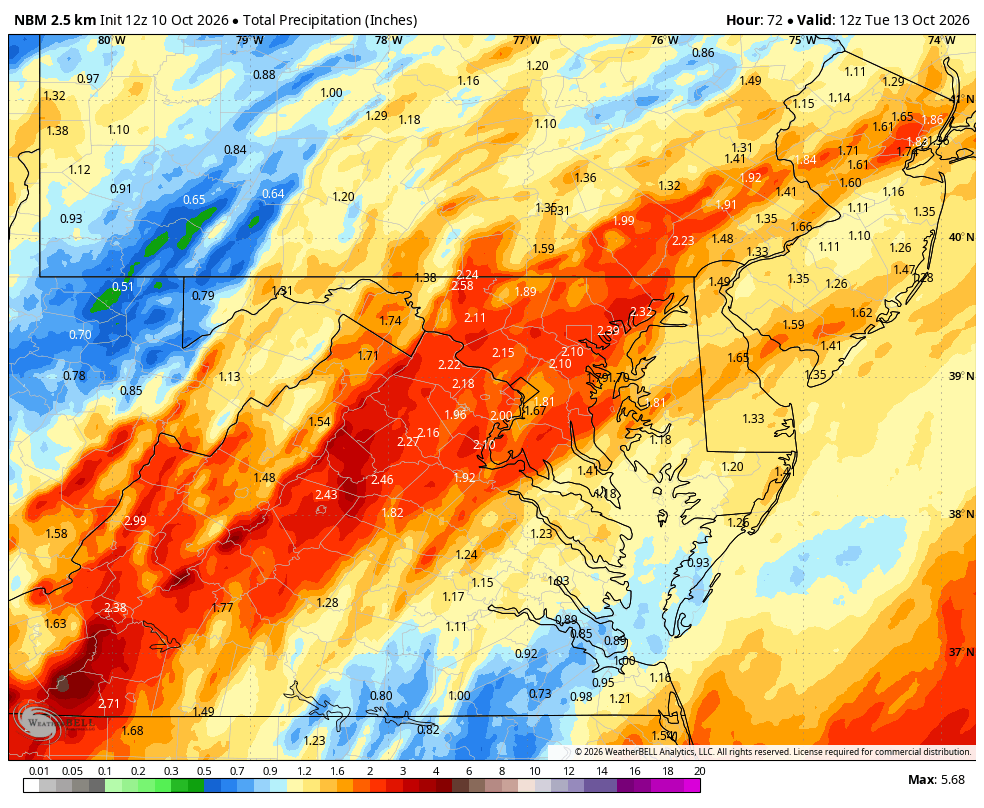
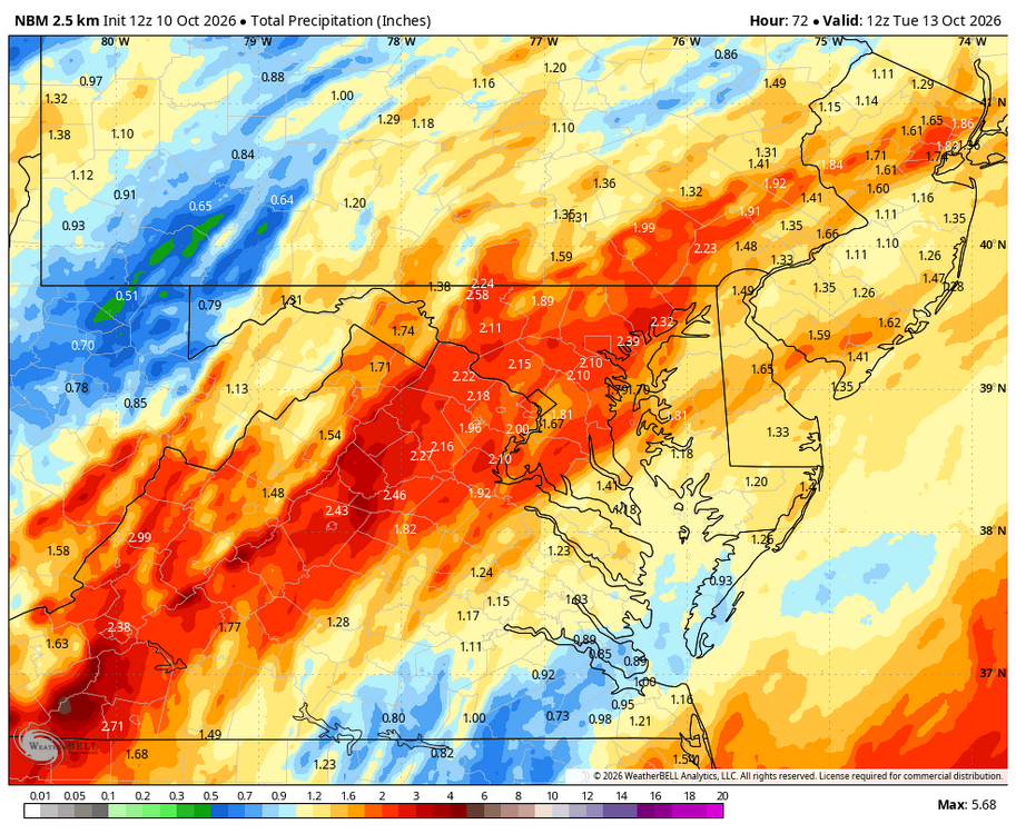
WB 12Z NBM
-
What are "swooping hodographs," other than a great name for a rock band according to Dave Barry?
-
For all the talk of wind measurements with landfalls, I agree the measurements we got from Isaias were impressive and suggest it probably was in fact a low-end cat 2 around the time of landfall. Given how quickly it was weakening at that point it wouldn’t surprise me if it did weaken slightly more than the operationally estimated 90kt at landfall, but the eyewall was impacting the coast when it was at that intensity. I agree with some points raised here - the maximum sustained winds are not something people should expect to see at their location on land, and properly communicating that (while still maintaining the proper level of urgency) is important. Even if you’re not seeing the max sustained winds on land, hazards such as wind damage and surge are very much proportional to those max sustained winds. You won’t see cat 5 sustained winds away from the coast in a cat 5 eyewall, but it would still be destructive and no one would be quibbling over it. Would also like to mention that when storms are sampled by recon, there is a wide array of instrumentation measuring winds at/near the surface and aloft, with well-researched and established reduction factors to equate low-level winds to the surface winds in these storms. The NHC is not just making up the max sustained winds. I do agree with the sentiment that NHC can be slow to operationally reduce the winds in storms that are weakening as landfall approaches, but understand why they’re cautious with that.