All Activity
- Past hour
-

February 2026 OBS & Discussion
PhiEaglesfan712 replied to Stormlover74's topic in New York City Metro
We do it again a month later. 1957-58 was a historical snow season. 2009-10 might have beaten it in terms of total snowfall, but the cold and snowy weather lingered a lot longer in 57-58. In 09-10, winter was long over by the time we got to the vernal equinox, and we were already 90 degrees by the first week of April. We didn't get that until late June in 1958. -

Wednesday Feb 18 Mixed event. NoP refresher?
ORH_wxman replied to HoarfrostHubb's topic in New England
NAMs went south a decent tick…RGEM and ICON very small ticks south. Basically noise on those two. -
of course
-
Less than an inch here in Garwood NJ. Within the range of most forecasts. However, my now casting skills are horrendous. I saw the precipitation shield last night and thought my area was in for at least 2 inches.
-
I had 18 over 3 days . My first year up here
-
Norrisville measured .1 of snow in their cocorahs report this AM
-

Wednesday Feb 18 Mixed event. NoP refresher?
dendrite replied to HoarfrostHubb's topic in New England
RGEM is Mitch to the Monads as well. Lighter accums across MA. -
LOL, I'm down to about 20%, mostly in shaded/N and drifted areas. But it was a fun 3 weeks.
-

Central PA Winter 25/26 Discussion and Obs
Itstrainingtime replied to MAG5035's topic in Upstate New York/Pennsylvania
I was! I have meetings all week on 2nd shift and drove home in the snow last night at 11pm. I measured .1" here at home at 1:30am. When I left work there was already more than that on top of Turkey Hill. Oh, I received .34" of QPF. -
Wednesday Feb 18 Mixed event. NoP refresher?
dendrite replied to HoarfrostHubb's topic in New England
Ended up being negligible change sensibly…Mitch to the Monads -

E PA/NJ/DE Winter 2025-26 Obs/Discussion
Albedoman replied to LVblizzard's topic in Philadelphia Region
Yes on Feb 1, I said 6-12 inches of snow and a pattern change. The pattern change has happened but unfortutantly I was off on the qpf by .50. Not to shabby. I also stated this on Jan 22, 2026 ----"1994 all over again folks if that happens" Well the storm did happen and the depth of cold we have had has rivaled 1994 This weekend' storm is a real crap shoot right now in our relaxed pattern but it would not suprise me at all we all get at least a foot of wet snow as the new pattern really sets in for more warmer temps in the first week in march. I am getting concerned that too much frozen precip right now will enhance ice jamming and flooding, especialy when the pattern gets really warm and perhaps even wet in early march. The temps in early march say we torch to 70 degrees on the GFS. The ice in the Upper Delaware river cannot deal with sudden temps changes into the 60 -70's and if we get heavy rainfall, the residents along the major tribs will be in trouble. -
I'm never touching March 4-6, 2001 again. what a nightmare with these PNS
-

Wednesday Feb 18 Mixed event. NoP refresher?
dryslot replied to HoarfrostHubb's topic in New England
Not expecting much of anything here for this one. -
i see i thought you were making a joke about combining the "EE" rule and "weekend" rule. But i have noticed a ton of big storms occurred on weekends Anyway, can you see my last post on new England snowstorm memories, if you have Mar 4-6, 2001 and Dec 30th, 2000, that would be helpful
-
.50” and the snowpack held in all undisturbed areas.
-

Wednesday Feb 18 Mixed event. NoP refresher?
Ginx snewx replied to HoarfrostHubb's topic in New England
NOP in title? -
...and that's completely fine by me! January was cold enough!
-

Wednesday Feb 18 Mixed event. NoP refresher?
metagraphica replied to HoarfrostHubb's topic in New England
Looking forward to melting some more of the pack! -

Central PA Winter 25/26 Discussion and Obs
canderson replied to MAG5035's topic in Upstate New York/Pennsylvania
Wind season is now November to April - every front seems to be bringing 30+ mph winds now. Colonoscopy all done. About to eat steak and eggs lol -
Start the thread then have it locked to increase the snow potential. Worked this storm lol
-
Wednesday Feb 18 Mixed event. NoP refresher?
dendrite replied to HoarfrostHubb's topic in New England
ICON has more confluence as well -
The past has no influence on the future. Extreme cold suppression depression is over
-
Wednesday Feb 18 Mixed event. NoP refresher?
dendrite replied to HoarfrostHubb's topic in New England
Hopefully no more snow for anyone -

2025-2026 ENSO
donsutherland1 replied to 40/70 Benchmark's topic in Weather Forecasting and Discussion
The latest AO forecast is even more aggressive with the development of an AO+: Given the other forecast teleconnections, this implies that the late February cold shot will likely be short-lived. Temperatures could return to near normal or above normal levels in the Great Lakes Region and Northeast in the closing days of the month.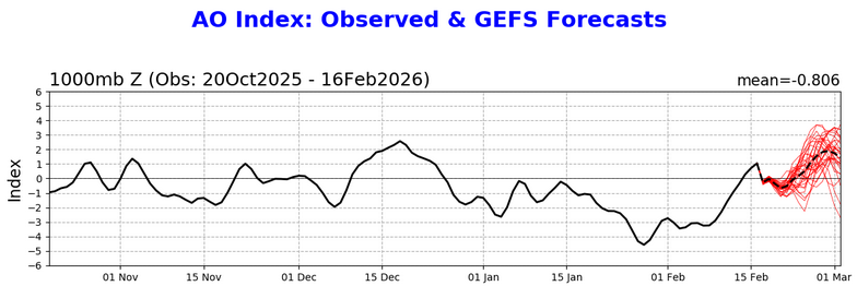
-
No it's not. First all of the top 5 nesis storms occurred here on a weekend. The EE rule states that if the Euro and ETA (old NAM) agreed it was a lock. If on a weekend then get ready


