All Activity
- Past hour
-
Low of 48. Chilly walk this morning with the pup.
-
Yeah, not good the next week or so. May be entering a wetter period after that as the ridge breaks down
-
Agreed. Something delicious about short sleeves in the 40s this time of year
-

2026-2027 Strong/Super El Nino
Stormchaserchuck1 replied to Stormchaserchuck1's topic in Weather Forecasting and Discussion
We might need a +5c El Nino to get that North Pacific High area - low pressure strong and persistent anomaly like 82-83 and 97-98. Right now I think the North pacific 500mb pattern may match 23-24 going forward more than other Stronger Nino's -
Records: Highs: EWR: 92 (1959) NYC: 93 (1881) LGA: 88 (1991) JFK: 89 (1991) Lows: EWR: 40 (1938) NYC: 40 (1907) LGA: 43 (1940) JFK: 43 (2020) Historical: 1760: Ben Franklin was the first person to identify nor'easters. In a letter on this date, Franklin described an experience that happened to him in November 1743 when storm clouds in Philadelphia blocked his view of an eclipse. Franklin assumed that the storm had blown in from the northeast because the surface winds at his location were from that direction. He was puzzled to find out later that his brother had viewed the eclipse with no problems and that the storm had arrived in Boston four hours later. The information caused Franklin to correctly surmise that the storm had moved from southwest to northeast. 1834: Unusual snows occurred across the Northeast. 6 inches fell at Erie, PA and 12 inches at Rutland, VT from this date through the 15th. 1876: The first American newspaper weather map was published in the New York Herald. Weather maps would first appear on a regular basis beginning on May 9, 1879 in the New York Daily Graphic. 1886: A tornado, which peaked at F4 intensity, touched down in Vermilion County near Armstrong, and passed between Alvin and Rossville before moving into Indiana. At least 5 houses were destroyed, two of which were totally swept away. Three people were killed. Five other strong tornadoes occurred across Illinois that day: two near Mt. Carroll, one near Odell, one near Jacksonville, and one in Iroquois County. A tornado killed 57 people as it passed through Greene and Huron Counties of Ohio leaving 43 dead in Xenia. (Ref. Wilson Wx. History) 1914: Record maximum temperature for Washington, DC for the date is 93 °F. (Ref. Washington Weather Records - KDCA) 1929: One of Virginia's worst tornado on record occurred on this date. 6 tornadoes touched down, including two west of the Blue Ridge Mountains, killing 22 people and destroying 4 schools. 13 of the victims were killed at Rye Cove in Scott County. (Ref. Wilson Wx. History) 1934 - A dust storm darkened skies from Oklahoma to the Atlantic coast. (David Ludlum) 1971 - Duststorms suddenly reduced visibilities to near zero on Interstate Highway 10 near Casa Grande AZ. Chain reaction accidents involving cars and trucks resulted, killing seven persons. (The Weather Channel) 1972 - In Texas, A cloudburst dumped sixteen inches of rain north of New Braunfels sending a thirty foot wall of water down Blueders Creek into the Comal and Guadalupe Rivers washing away people, houses and automobiles. The flood claimed 18 lives and caused more than twenty million dollars damage. (The Weather Channel) 1980: Cheyenne, WY received 3.8 inches of snow. It turned out to be the last snow of the 1979-80 season which produced a record 121.5 inches of snowfall. On the same day Scottsbluff, NE received just under an inch of snow (0.8 inches) which brought their snow season to an end with a record 78.5 inches. (Ref. Wilson Wx. History) 1982 - A late season snowstorm struck the Front Range of the Colorado Rockies. The storm produced 46 inches of snow at Coal Creek Canyon, located near Boulder. (David Ludlum) 1983: Heavy wet snow fell on this date through the 12th across parts of Montana. Snowfall totals included: Pryor: 22 inches, Melstone: 19 inches, Hysham: 18 inches, Broadus: 17 inches, Red Lodge: 16 inches, Plevna: 15 inches, Columbus: 14 inches, Nye: 13 inches, Baker: 13 inches, Billings: 12 inches, Forsyth: 12 inches and Miles City: 12 inches. (Ref. Wilson Wx. History) 1987 - A heat wave persisted in central California. Afternoon highs of 100 degrees at Fresno CA and 102 degrees at Sacramento CA were records for the date. (The National Weather Summary) 1988 - Unseasonably warm weather prevailed in the western U.S. Eight cities reported record high temperatures for the date, including Pendleton OR with a high of 92 degrees and Phoenix AZ with a reading of 106 degrees. (The National Weather Summary) 1989 - Showers and thunderstorms associated with a low pressure system stalled over New York State drenched Portland ME with 4.50 inches of rain in 24 hours. Rains of 5 to 7 inches soaked the state of Maine over a four day period causing 1.3 million dollars damage. (The National Weather Summary) (Storm Data) 1990 - Thunderstorms produced severe weather from eastern Texas and the Central Gulf Coast States into Missouri and Illinois. Thunderstorms spawned six tornadoes, including one which injured four persons at Doloroso MS. Thunderstorms also produced hail three inches in diameter west of Vicksburg MS, and wind gusts to 83 mph in southern Illinois, north of Vevay Park and at the Coles County Airport. High winds and heavy rain caused 1.6 million dollars crop damage in Calhoun County IL, and in southeastern Louisiana, Saint Joseph was deluged with eight inches of rain. (The National Weather Summary) (Storm Data) 1997: A towering tornado ripped its way through the middle of Miami, Biscayne Bay and Miami Beach right after lunch Monday, smashing cars and windows, tossing trees skyward and scaring the dickens out of thousands of people. (Ref. Miami, Biscayne Bay Tornado Story with the Tornado Image) 2000: Severe thunderstorms produced hail up to 2.5 inches in diameter from Eureka to Roanoke, causing $300,000 damage to 100 cars. This was part of a cluster of severe thunderstorms, producing hail in a large area from the Illinois River to the Indiana border. (Ref. Wilson Wx. History)
-
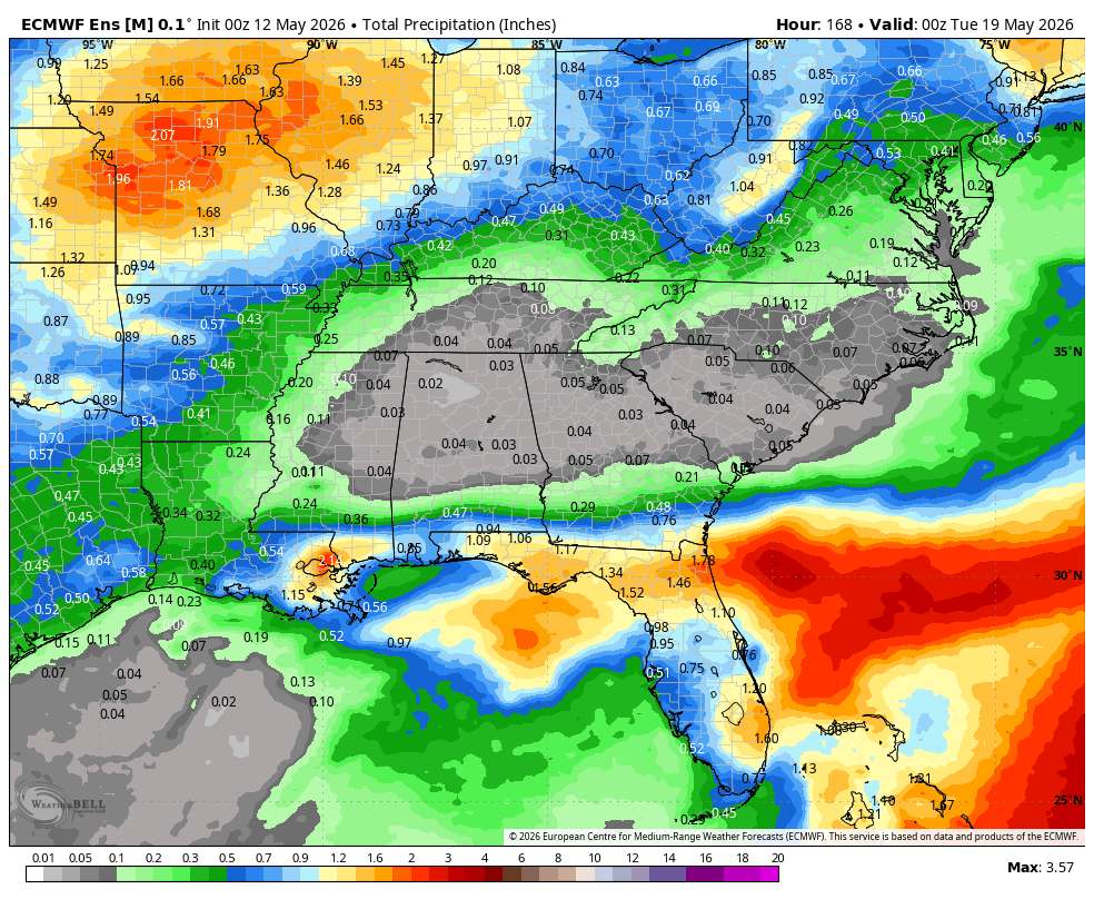
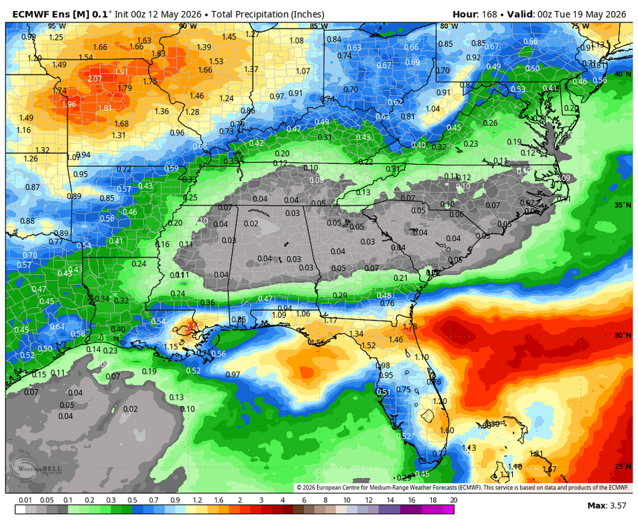
55 / 31 sunny. Nicest day of the next 3 still a bit below normal but a pleasant mid - upper 60s. Clouds showers back Wed - Thu and rain looks in the 0.5 - 1.0 range in the wettest scenario. Clearing out as the closed upper trough rolls through. Much warmer by Sat and into next week with above to much above normal >80 and some 90s potentially. Beyond there overall warmer perhaps some onshore influence especially at the coast/beaches. But overall ridging into the east 5/17 - beyond.
-
That would be bad... That is the Stars and Strikes tournament in Elkridge
-
Chilly morning out this way… but beautiful blue skies.
-

2026-2027 Strong/Super El Nino
snowman19 replied to Stormchaserchuck1's topic in Weather Forecasting and Discussion
Let’s see what the westerlies/WWBs, +IOD and TC’s do over the next few months….how far east do they push that warm pool? -
I still dislike Mayo
-
We’re getting some rain this morning from the N edge of the precip. area. The possibility of rain for today wasn’t even mentioned in the forecast for this far N until late last night as the N edge of rain chances had been forecasted S of here. Temps are in the middle 60s.
-
Got down to 32° on the dot this morning.
-
(002).thumb.png.6e3d9d46bca5fe41aab7a74871dd8af8.png)
Central PA Spring 2026 Discussion/Obs Thread
ChescoWx replied to Voyager's topic in Upstate New York/Pennsylvania
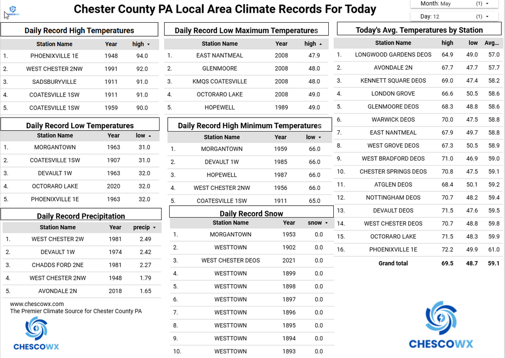
Widespread lows were in the 30’s overnight with some valley locations near or below freezing this morning. The lowest reading was the 31.5 at Warwick Township. That is tied for the 2nd coldest reading for today’s date across Chester County behind only the 31-degree low recorded at Coatesville in 1907 and Morgantown in 1963, That may well be our last freezing observation across the county until October. We continue with below normal temperatures through the rest of the work week before we warm up to well above normal temperatures starting Saturday and into next week. Rain chances increase by tomorrow night into Thursday morning.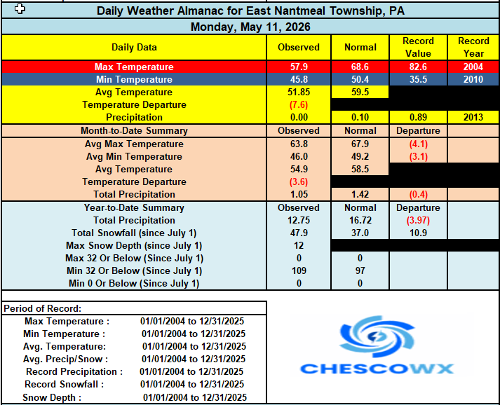
-
E PA/NJ/DE Spring 2026 Obs/Discussion
ChescoWx replied to PhiEaglesfan712's topic in Philadelphia Region
Widespread lows were in the 30’s overnight with some valley locations near or below freezing this morning. The lowest reading was the 31.5 at Warwick Township. That is tied for the 2nd coldest reading for today’s date across Chester County behind only the 31-degree low recorded at Coatesville in 1907 and Morgantown in 1963, That may well be our last freezing observation across the county until October. We continue with below normal temperatures through the rest of the work week before we warm up to well above normal temperatures starting Saturday and into next week. Rain chances increase by tomorrow night into Thursday morning.
-
I drove through the East Quabbin hill towns yesterday. Wilderness with scattered houses. It’s so rural. Good sandwiches at Petersham Country Store though.
- Today
-
I love these chilly nippy May days
-
Weekend looks great. Heat building early next week - 80s-90 Tuesday and Wednesday looks possible
-
.87" total rain yesterday. Wonderful!! Low of 34.9 with clouds and fog.
-

Central PA Spring 2026 Discussion/Obs Thread
mahantango#1 replied to Voyager's topic in Upstate New York/Pennsylvania
It gets any colder you'll be posting snow maps. -

Central PA Spring 2026 Discussion/Obs Thread
Blizzard of 93 replied to Voyager's topic in Upstate New York/Pennsylvania
37 low in Marysville -

Central PA Spring 2026 Discussion/Obs Thread
Jns2183 replied to Voyager's topic in Upstate New York/Pennsylvania
Thursday with highs in the upper 50's seems like the last chilly day until fall. Maybe we can sneak in a few backdoor fronts in June and have a couple relief days of drizzle. Sent from my SM-S731U using Tapatalk -
Central PA Spring 2026 Discussion/Obs Thread
Jns2183 replied to Voyager's topic in Upstate New York/Pennsylvania
The one day in July I was stuck in Houston because storms cancelled my flight made me amazed anything ever was built down there. I never had so many big bites. Sent from my SM-S731U using Tapatalk -
There’s nothing anyone could possibly get out of that. It means heat on in cars and houses and extreme irritability if they live there.
-
There’s about three people and some black bears that live there.
-
41.9 for the low, impressive amount of mid 30s in northern piedmont including my farm in Louisburg at 35.5! Won’t see these temps again till next fall