All Activity
- Past hour
-
Also for this weekend I wouldn't be surprised to possibly see some snow flying around Sunday morning.
-
Ok so we basically have 2 potentials for some snow. One is next Thursday and the other is possibly next weekend. Both of these systems I'd be extremely cautious with. We are seeing changes from run to run and this is about a week to 10 days out.
-

Central PA Winter 25/26 Discussion and Obs
Mount Joy Snowman replied to MAG5035's topic in Upstate New York/Pennsylvania
Yeah I'm surprised by that but good to hear. -
-
Good to see some positives within range on the map. Always remember the 3 day rule though.
-
The 1960s had the best Long Island and surrounding area radiational cooling following the big snowstorms of that era. for January 21, 1961 through January 31, 1961 Click column heading to sort ascending, click again to sort descending. NY SHRUB OAK COOP -25 NY CARMEL COOP -24 NJ CANOE BROOK COOP -21 CT WESTBROOK COOP -21 NY PORT JERVIS COOP -20 CT WATERBURY RADIO WBRY COOP -19 NJ CHARLOTTEBURG RESERVOIR COOP -18 CT STAMFORD 5 N COOP -18 CT MOUNT CARMEL COOP -17 NY SUFFERN COOP -16 CT DANBURY COOP -16 NY BEDFORD HILLS COOP -16 NY STEWART FIELD WBAN -15 NJ WANAQUE RAYMOND DAM COOP -14 CT GROTON COOP -14 CT NORWICH PUBLIC UTILITY PLANT COOP -13 NY PATCHOGUE 2 N COOP -12 CT COLCHESTER 2 W COOP -12 NJ LITTLE FALLS COOP -11 NY MIDDLETOWN 2 NW COOP -10 NY SCARSDALE COOP -10 NY WESTCHESTER CO AP WBAN -10 NJ ELIZABETH COOP -10 CT MIDDLETOWN 4 W COOP -10 NY WEST POINT COOP -7 CT NORWALK GAS PLANT COOP -7 NJ PLAINFIELD COOP -7 CT NEW HAVEN TWEED AP WBAN -7 NY HEMPSTEAD GARDEN CITY COOP -2 NY SETAUKET STRONG COOP -2 NY RIVERHEAD RESEARCH FARM COOP -2 NY BRIDGEHAMPTON COOP -2 CT IGOR I SIKORSKY MEMORIAL AIRPORT WBAN -1 NJ PATERSON COOP -1 NY WESTHAMPTON GABRESKI AP WBAN -1 Monthly Snowfall Data for January 1961 for Upton NY NWS CWA Click column heading to sort ascending, click again to sort descending. NY WARWICK COOP 45.2 NY GARDNERVILLE COOP 44.0 NJ GREENWOOD LAKE COOP 37.6 NY PORT JERVIS COOP 37.2 NY WEST POINT COOP 35.9 CT WOLCOTT RESERVOIR COOP 33.5 NY DOBBS FERRY-ARDSLEY COOP 32.7 NJ PATERSON COOP 32.5 NJ MAHWAH COOP 32.0 NY WESTCHESTER CO AP WBAN 31.1 NJ MIDLAND PARK COOP 31.0 NJ CHARLOTTEBURG RESERVOIR COOP 31.0 NY SCARSDALE COOP 30.9 NY CARMEL COOP 30.0 NJ CANOE BROOK COOP 29.0 NY STEWART FIELD WBAN 28.0 NY BEDFORD HILLS COOP 27.7 NJ RINGWOOD COOP 27.5 NY SHRUB OAK COOP 27.5 NY BRIDGEHAMPTON COOP 27.4 CT STAMFORD 5 N COOP 27.0 CT MIDDLETOWN 4 W COOP 26.2 CT COCKAPONSET RANGER STA COOP 25.0 NJ WANAQUE RAYMOND DAM COOP 24.0 NJ LITTLE FALLS COOP 22.8 CT WATERBURY RADIO WBRY COOP 22.5 NJ NEWARK LIBERTY INTL AP WBAN 22.2 NY PATCHOGUE 2 N COOP 21.6 NY NY WESTERLEIGH STAT IS COOP 21.5 NY WESTHAMPTON GABRESKI AP WBAN 21.5 NJ CEDAR GROVE COOP 21.0 NY SUFFERN COOP 20.6 NJ PLAINFIELD COOP 20.5 NJ IRVINGTON COOP 20.5 NY HEMPSTEAD GARDEN CITY COOP 20.5 CT COLCHESTER 2 W COOP 20.2 NY NEW YORK LAUREL HILL COOP 20.0 NY MINEOLA COOP 20.0 CT DANBURY COOP 20.0 CT NEW HAVEN TWEED AP WBAN 20.0 CT GROTON COOP 20.0 Data for February 7, 1967 through February 14, 1967 Click column heading to sort ascending, click again to sort descending. NY STEWART FIELD WBAN -20 NY SHRUB OAK COOP -16 NY MIDDLETOWN 2 NW COOP -16 CT COLCHESTER 2 W COOP -15 CT WESTBROOK COOP -15 NY ISLIP-LI MACARTHUR AP WBAN -14 NY CARMEL COOP -12 CT MOUNT CARMEL COOP -12 CT STAMFORD 5 N COOP -11 CT DANBURY COOP -10 CT MIDDLETOWN 4 W COOP -10 NJ CHARLOTTEBURG RESERVOIR COOP -10 NY PORT JERVIS COOP -10 CT GROTON COOP -9 CT NORWICH PUBLIC UTILITY PLANT COOP -9 NJ CANOE BROOK COOP -9 NY SUFFERN COOP -8 CT NORWALK GAS PLANT COOP -7 NY SCARSDALE COOP -6 NY WESTCHESTER CO AP WBAN -6 NY YORKTOWN HEIGHTS 1W COOP -5 NY WESTHAMPTON GABRESKI AP WBAN -5 NY BEDFORD HILLS COOP -4 NJ WANAQUE RAYMOND DAM COOP -4 NY WEST POINT COOP -4 NY PATCHOGUE 2 N COOP -4 CT NEW HAVEN TWEED AP WBAN -3 CT IGOR I SIKORSKY MEMORIAL AIRPORT WBAN -2 NJ PLAINFIELD COOP -2 NJ LITTLE FALLS COOP -2 NY HEMPSTEAD GARDEN CITY COOP -1 Monthly Snowfall Data for February 1967 for Upton NY NWS CWA Click column heading to sort ascending, click again to sort descending. CT WOLCOTT RESERVOIR COOP 34.2 CT COLCHESTER 2 W COOP 33.2 CT EASTON RESERVOIR COOP 32.5 CT COCKAPONSET RANGER STA COOP 32.3 NY STEWART FIELD WBAN 32.1 NY WARWICK COOP 32.1 CT DANBURY COOP 31.6 NY BRIDGEHAMPTON COOP 30.5 NY SCARSDALE COOP 30.5 NY WESTCHESTER CO AP WBAN 29.6 NY NY WESTERLEIGH STAT IS COOP 29.5 CT TRAP FALLS RESERVOIR COOP 29.5 NJ PLAINFIELD COOP 29.1 NJ CHARLOTTEBURG RESERVOIR COOP 28.6 NY BEDFORD HILLS COOP 28.5 NY DOBBS FERRY-ARDSLEY COOP 28.1 NY MINEOLA COOP 28.0 NY PATCHOGUE 2 N COOP 27.8 NY NEW YORK LAUREL HILL COOP 27.7 CT WESTBROOK COOP 27.6 NJ MIDLAND PARK COOP 27.5 NY WESTHAMPTON GABRESKI AP WBAN 27.3 NJ CANOE BROOK COOP 27.0 NY CARMEL COOP 27.0 NJ PATERSON COOP 26.8 NJ WANAQUE RAYMOND DAM COOP 26.6 NY WEST POINT COOP 26.3 NY YORKTOWN HEIGHTS 1W COOP 26.0 NY SHRUB OAK COOP 25.5 NJ NEWARK LIBERTY INTL AP WBAN 25.4 CT NEW HAVEN TWEED AP WBAN 25.3 CT MIDDLETOWN 4 W COOP 25.3 CT STAMFORD 5 N COOP 25.3 NY GARDNERVILLE COOP 25.0 CT MOUNT CARMEL COOP 24.6 NY RIVERHEAD RESEARCH FARM COOP 24.3 CT NORWALK GAS PLANT COOP 24.3 NY NEW YORK AVE V BROOKLYN COOP 24.0 CT IGOR I SIKORSKY MEMORIAL AIRPORT WBAN 24.0 NY HEMPSTEAD GARDEN CITY COOP 23.8 NY PORT JERVIS COOP 23.7 NY NY CITY CENTRAL PARK WBAN 23.6 NJ GREENWOOD LAKE COOP 20.5 NY LAGUARDIA AIRPORT WBAN 20.0
-
We will see for yall outside the mountains. I've seen a lot of heartbreak with yall. The next 7 days look decent.
-
throwback DT post
-

January 2026 regional war/obs/disco thread
VivaManchVegas replied to Baroclinic Zone's topic in New England
Up to 45 today. The snow pack is only 4 inches but it is dense. -
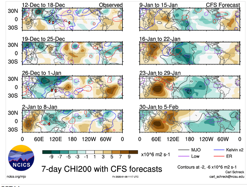
Seemingly we are starting to see a pattern change upcoming,the tropical forcing is getting taken out of the WP/MC which is what we've been seeing literally since fall I'm using the GEFS and CFS I.E,take out the tropcial forcing you dont see these troughs going trough East Asia,
-
This puzzle will have many moving parts, but, as currently depicted, the 95 corridor probably does better than western areas for the 18th and 19th. I don't like complication.
-

January 2026 regional war/obs/disco thread
brooklynwx99 replied to Baroclinic Zone's topic in New England
dude, I don't have to post when things look crappy. everyone knows it looks crappy when the pattern is unfavorable and I don't find SE ridges and 50 degree weather interesting, so I don't really post about them. that is the case for most people here though, I should make sure that I hold my posts to your stringent standards; I'm sure everyone on this forum would appreciate if I had such unbiased analysis as yourself -

Central PA Winter 25/26 Discussion and Obs
Itstrainingtime replied to MAG5035's topic in Upstate New York/Pennsylvania
Add the MU warminsta to the group who is invested in next weekend's storm. Says the event centered around Thursday will just be a frontal passage, but he's going to be issuing a first look outlook for next weekend on Tuesday. For him to say that now, he's onboard. (not that we need that but if HE'S onboard, it's telling.) -
Good 12z suite. In the meantime, some beneficial rains will occur before the cold moves in on Sunday. I think everyone has pretty much taken care of the 12z disco...not much to add from me!
-

January 2026 regional war/obs/disco thread
WinterWolf replied to Baroclinic Zone's topic in New England
I understand this all the time….but at some point there’s a point where there’s enough venting too. And you just suck it up. Or log off. And it’s not all positive all the time. I got no issues saying it sucks when it does. -
12z EPS for both storms.
-
Super.
-

Pittsburgh/Western PA WINTER ‘25/‘26
jwilson replied to Burghblizz's topic in Upstate New York/Pennsylvania
Difficult to buy into anything right now. Mid-range modeling has been suspect for a few months. Long-range is worth even less. I'm not too worried about individual threats until they close within three-to-five days. The best we might hope for is a return to the December clipper-heavy pattern. I think it is possible, if not probable, that the worst of our winter cold is over with, however. Height anomalies over Canada don't look quite as robustly cold as they were a month ago, and a massive building -EPO coupled with +PNA might reconfigure how cold air gets moved through the CONUS. A huge ridge out west precludes cold air from coming at us in a westerly fashion and retains a more northern component. The ridge does create opportunities for storms to ride down the spine and amplify south of us, but the speed of the northern stream combined with a lack of blocking really caps any potential. Even a big coastal would move in a hurry absent additional variables that aren't yet clear. The combination is a somewhat typical Nina atmosphere. Not to say the rest of winter will be warm, only that it is more moderate than what we dealt with previously with quite negative departures. A February warm-up is always a threat. If you do believe anything very long-range, the data itself doesn't yet support that outcome. Cold conditions may be bolstered if the MJO eventually traverses through Phase 7 as currently progged. -
Today's record low for Islip is -4 from 1968.
-

January 2026 regional war/obs/disco thread
CT Valley Snowman replied to Baroclinic Zone's topic in New England
Up to a balmy 48 here. -
Same to you.
-
EPS doesnt support a Cutter
-

January 2026 regional war/obs/disco thread
Typhoon Tip replied to Baroclinic Zone's topic in New England
Euro's all over the place not saying your wrong or even off ...but we're analyzing shitness from where i'm sitting, this one run appears to be favoring the 2nd wave in that broadly interfering headache, while simultaneously speeding up the 2nd wave... it was the 19th and 20th last night. yikes -
We were a heat island before heat islands were cool.
-
I mean this as nicely as possible but you may be better served by reading more and posting less. The amount of posts you’ve shared that make little to no sense and provide no value is kind of baffling. A little self awareness goes a long way!


