All Activity
- Past hour
-
No that level of weenie transcends the forum. Look at Twitter, especially Webb’s before he did his about face around Christmas.
-

January 2026 regional war/obs/disco thread
Damage In Tolland replied to Baroclinic Zone's topic in New England
If you want blood.. you got it ! -

Central PA Winter 25/26 Discussion and Obs
mahantango#1 replied to MAG5035's topic in Upstate New York/Pennsylvania
-
Got a 1/2in from French Ticklers off of the lake down here. Moderate wind damage reports around the area, that was the bigger story along with the temp bottom falling out. 15 gusts over 50 at my station with a 10 min 38+ sustained period. Left Fl to get Tropical Storm force winds up here lol.
-
(002).thumb.png.6e3d9d46bca5fe41aab7a74871dd8af8.png)
Central PA Winter 25/26 Discussion and Obs
ChescoWx replied to MAG5035's topic in Upstate New York/Pennsylvania
Winds have been howling much of the night and will continue this morning before slowly subsiding later today. The sun returns today but we stay with well below normal temperatures for at least the next week with temperatures remaining below freezing till at least Saturday. We only warm slightly to just above freezing this weekend into early next week. There is a chance of a little snow later New Years Eve into New Years Day. If we do see some snow amounts should be light.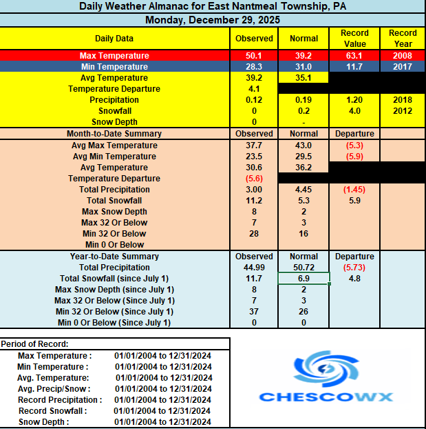
-
E PA/NJ/DE Winter 2025-26 Obs/Discussion
ChescoWx replied to LVblizzard's topic in Philadelphia Region
Winds have been howling much of the night and will continue this morning before slowly subsiding later today. The sun returns today but we stay with well below normal temperatures for at least the next week with temperatures remaining below freezing till at least Saturday. We only warm slightly to just above freezing this weekend into early next week. There is a chance of a little snow later New Years Eve into New Years Day. If we do see some snow amounts should be light.
-

January 2026 regional war/obs/disco thread
40/70 Benchmark replied to Baroclinic Zone's topic in New England
Yea, def. a very bad sign if we don't get anything major in the next two weeks. -

January 2026 regional war/obs/disco thread
WinterWolf replied to Baroclinic Zone's topic in New England
What was the one that gave central CT 12-16” on Feb 13, 2024. Was that near the benchmark? -
Who was the met?
-

January 2026 regional war/obs/disco thread
Cyclone-68 replied to Baroclinic Zone's topic in New England
As a novice/amateur I’d state it’s too soon to give up but if we stay dry thru mid Jan with nothing still on the horizon, it’s lights out I think. -
New Years Day 2026 - 1st snows of the new year possible
WinterWolf replied to Baroclinic Zone's topic in New England
If this follows the tenor of this season…it’ll probably juice up some. 1-3” would be a nice refresher. -

January 2026 regional war/obs/disco thread
TauntonBlizzard2013 replied to Baroclinic Zone's topic in New England
I know we had one that was rain last year -
Can confirm we had about 1/2 inch overnight. I'm about 5.1 miles NNE of Jonesborough on the map, south of I-81. Was a total surprise. https://freeimage.host/i/fXqnsh7 https://freeimage.host/i/fXqn4kl https://freeimage.host/i/fXqnLQ9
-
January 2026 regional war/obs/disco thread
40/70 Benchmark replied to Baroclinic Zone's topic in New England
Either Jan 2024 or 2022 -
Earthlight likes the pattern ahead for a big east coast snowstorm.
-
Agreed. This pattern is good for some lighter snows, but until we have a big PNA spike, no larger storm is making its way to our area. I think the OPs and the Ensembles were overzealous with the large storms they were depicting past few days. In reality, they were probably just signaling a pattern change, but the way models are….. you know the rest
-
Whether you like Bamwx or not, he has some great explanations for coming pattern, and should watch.
-
-
Its always the same person who keeps doing it.
-

January 2026 regional war/obs/disco thread
Sey-Mour Snow replied to Baroclinic Zone's topic in New England
She was the last benchmark ish bomb? -
January 2026 regional war/obs/disco thread
40/70 Benchmark replied to Baroclinic Zone's topic in New England
What I will say is that I think guidance is underselling the emergence of the PNA...I can see this storm burgeoning back into existence with relatively little lead time when that correction is made. -
he also said to ignore the models that showed a warm Dec 18-28 window because of Phase 8. bad bam bad bam
-
"a model run comes in, people rejoice. a model run comes in, people jump off a cliff" - he must browse this forum.
-
Very astute observation there PF! We were all standing at the top of Vista Peak and commenting on the amazing views of the Adirondacks/Whiteface (along with most visitors that were getting off the lift) and my younger son caught that nuance of the view immediately. He was quickly looking for a word and in the guessing game I threw out “mirage” and a few other things until my wife finally realized he was looking for “mesa”. What he had actually first noticed was how surprisingly glacier-like that col to the right of Whiteface looked (more than usual), and we started talking about local examples like Lake Willoughby. It was shortly after that when the flat appearance of the peaks to its right caught our attention. I did comment that the col looked a bit more U-shaped than usual, but without the aid of the lens, it wasn’t immediately obvious whether the overly flat appearance of the peaks to the right was due to mirage or simply due to a localized area with a lower cloud ceiling. But once you see the image with the help of the camera lens, its very obvious that its Fata Morgana – you can see the refraction ripples in various spots in the image. It’s interesting that the area around Whiteface itself seemed less affected, but I bet more people would have noticed with the naked eye if something had been going on there.
-
January 2026 regional war/obs/disco thread
WinterWolf replied to Baroclinic Zone's topic in New England
That ain’t science Paul…it’s seeing that what you’re saying isn’t applying to any other region at this time. And What I have that you don’t is life experience…your a kid that hasn’t lived through what I have. I’ve seen this shit before first hand…you have not. So perhaps, you are the one that doesn’t understand.


