All Activity
- Past hour
-
Plenty of time to trend that press stronger to get more posters in the game for a front ender at least. This isn’t cutting to the lakes. 6z euro shows how to get it done
-

White Christmas Miracle? December 23-24th
weatherwiz replied to Baroclinic Zone's topic in New England
There should be some decent frontogenesis that crosses the region. Still have a quite a bit to iron out with the details but there should be a sizable swath of 1-3 inches. Def some concerns with boundary layer temps in some spots, but that won't be much of a concern if we get a decent precip. shield and a far enough south track. -
Who cares about rain and 40s? This is the day after Christmas, looks fun!
-

December 2025 regional war/obs/disco thread
TauntonBlizzard2013 replied to Torch Tiger's topic in New England
Warmer than 6z. Keeps only far northern areas frozen -

2025-2026 ENSO
donsutherland1 replied to 40/70 Benchmark's topic in Weather Forecasting and Discussion
Webb describes a plausible scenario. It's not the only possibility, despite his skill and expertise. Prior to about 1980, December PNA- cases (-0.500 or below average) were typically followed by January PNA- cases. Since 1980, most cases have seen the PNA flip in January. The difference in PNA persistence could reflect the changes that have taken place due to Arctic amplification rather than statistical factors e.g., sample size. With Arctic sea ice extent continuing to set new daily record lows, the risk of a fairly abrupt change can't be ruled out. That there has been a strong clustering of December-January cases prior to and after 1980 (Dec PNA-/Jan PNA- prior to 1980 and Dec PNA-/Jan PNA+ since 1980) suggests that more than random variability is involved. That does not guarantee a flip to positive for January, but model skill at such a timeframe is essentially non-existent. Yes, both the EPS and GEFS paint a picture of a perpetual PNA-. But that's current modeling. The long-range isn't cast in stone, at least as far as January is concerned. Assuming a canonical La Niña winter, I think things are tilted toward a warm February, especially in the East. -
Exactly. All too often there are 2 modes of thinking here... wall to wall good or door to door turd lol. Through history the vast majority of our winters fall in between. A general mix of good periods and blind shitting. Simply guessing an in between winter is the highest odds and the most common outcome. This winter sure feels like an in-betweener to me
-

White Christmas Miracle? December 23-24th
WxWatcher007 replied to Baroclinic Zone's topic in New England
Still have to watch for some warmth but yeah, not bad for CT. -
December 2025 regional war/obs/disco thread
WxWatcher007 replied to Torch Tiger's topic in New England
No dice on the GFS on Boxing Day but it does have ice to snow in NNE from a pretty strong storm. -

White Christmas Miracle? December 23-24th
Snowcrazed71 replied to Baroclinic Zone's topic in New England
Well... That looks a lot better as far as precipitation amounts for most ( although interior SE Mass seems to have stayed the same ) -
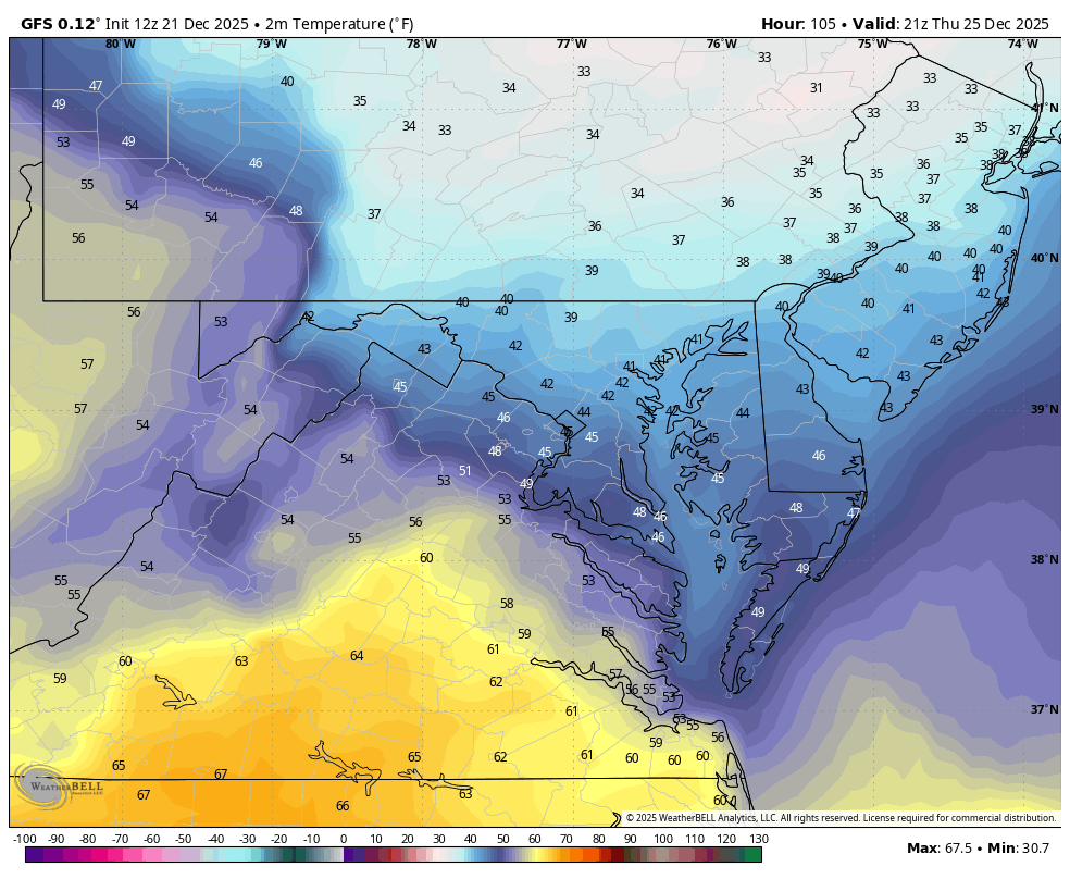
WB 12Z GFS for Christmas....rain and 40s....our specialty. Also perfect example on taking models with a BIG grain of salt outside a few days. No torchmas, just rawmas...

-
Yes, generator is absolutely necessary on my road. Hundreds of dead trees all along the length of it. Power came back on at 8:19 this morning. So a little over 45 hours.
-
Uh oh I saw geese flying north today.. Webb is right
-
The NYC area is modeled to get some more snow on Tuesday.
-
Isn’t Webb living in New Mexico or somewhere like that? I can see why he would be frustrated wrt his backyard snowfall prospects (lack of STJ), but to paint that as “winter’s over” for the entire country/EC is a bit much. Some stretches are gonna suck, others may be decent. I still don’t think this is a one track winter.
-
What doesn’t help is that Webb has been known to call people out who challenge him. Last week he was running rings around the people doubting torchmas in the east screenshotting model runs that showed muted warmth in our area and below normal in New England. Flash forward to now and looking at the 7 day on Google for DC it’ll be AN but it’ll be low 50s instead of low 60s which was forecasted a couple days ago.
-
White Christmas Miracle? December 23-24th
WxWatcher007 replied to Baroclinic Zone's topic in New England
With apologies to the NNE crew (but note up near PWM) 06z 12z -
And after that period it looks to go right back to warm
-
Not buying Webb's latest. He had cold/blocking scenarios loaded up and ready to go. His science behind the logic is sound here in that we need change, but it's not curtains through February from what I'm seeing. To attribute this all to Nina when the actually ENSO state is so weak in that direction is also a bit incorrect.
-
It’s not a perfect comparison but trusting a single good poster on Twitter for how the whole season is gonna go will work as well as trusting a fantasy football analyst for your week to week start/sits. Nobody knows. Strange things happen. Random players can have a home run game. We’ve got 3 months to go in winter where it can be significantly snowy around here. Cannot possibly wave a white flag yet.
-
Webb says we're screwed https://x.com/webberweather/status/2002755646454993016 https://x.com/webberweather/status/2002759593269792869
-

Winter 2025-26 Short Range Discussion
Brian D replied to SchaumburgStormer's topic in Lakes/Ohio Valley
Christmas Day may be a LES or lake enhancement with synoptic snows across NE MN. Looks like a possible def zone between HP n LP setting up. A long fetch from the ENE across the Lake usually gives something, especially with a boundary hanging out. -

MO/KS/AR/OK 2025-2026 Winter Discussion
NWAflizzard replied to stormdragonwx's topic in Central/Western States
This has to be the biggest spread I’ve seen on the AO forecast.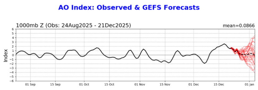
-
It has zero ensemble support so we’ll see. Even if it did, I don’t want to be in the bullseye for at least another 6 days. That time period does look interesting though. It seems like we get a brief break from warmth but it’s an all or nothing type of look.
-

Possible Light Snowfall (1" - 4") on Tuesday Dec 23
WeatherGeek2025 replied to Northof78's topic in New York City Metro
this would be considered a white Christmas -
White Christmas Miracle? December 23-24th
WxWatcher007 replied to Baroclinic Zone's topic in New England
Back to wx. It’s definitely tenuous for coastal areas, but you can see how a slightly more robust system is very good for much of the subforum being in striking distance of a widespread 2-4” event. I’d still lean 1-3” generally given the track and possibility we can’t amplify this to its ceiling, but still solid minor snow in advance of the holiday.