All Activity
- Past hour
-
Models having inherent biases have nothing to do with cherry picking. They are a function of the way the models work. The CanSIPS is well known for showing too much cold where the troughs are forecast especially in the East. One of the few parts of the country that can verify colder than these seasonal forecasts is the Rockies and Upper Plains. But that doesn’t do the posters living in the I-95 corridor any good. Plus the forecasts beyond one month are a crap shoot anyway. So don’t get too attached to what any of the seasonal models are showing now for next winter. The CanSIPS and other models don’t have a ton of skill forecasting the 500mb pattern more than 30 days out. So we have to wait until the 1st of each month for the monthly forecast. Then adjust the temperatures warmer in the spots where a trough is indicated for models like the CanSIPS, With the exception of Western areas which can sometimes verify colder. But usually not the East.
-
I'm in Chicago until 7/21, and I'm sure not loving this humidity. Any chance of a real cold front in the foreseeable future that will knock the DPs down to 50 or below??
-
Iowa scraps yesterday gave .02”. Drought feedback loop in full effect
-
Typical MA summer. At least it doesnt look boring. Nothing worse than brutal heat and humidity with no trigger for storms. Snippet from the latest Mount Holly AFD-
-

July 2025 Obs/Disco ... possible historic month for heat
kdxken replied to Typhoon Tip's topic in New England
Ditty doing hurricane forecasting now? -
July 2025 Obs/Disco ... possible historic month for heat
kdxken replied to Typhoon Tip's topic in New England
You can certainly tell which way it was leaning..jpg.f20e5e75c98ffece771c4a45c4df430d.jpg)
-
Dews have mercifully dropped to the 58-60 range, after hanging around 70-72 the past two days.
-

July 2025 Discussion-OBS - seasonable summer variability
SACRUS replied to wdrag's topic in New York City Metro
81 / 66 -
After the last 2 days with below normal temperatures we will see increasingly warm and humid weather today and through much of next week. Today looks like it is the only day that should stay dry. Rain chances will continue all week. The best chances of heavy rain look to be Monday into the evening. Wednesday looks to be the relatively driest day. Today should be our warmest day of the week with lower elevation spots across the county possibly touching 90 degrees while ridge locales will likely only reach the upper 80's.
-

E PA/NJ/DE Summer 2025 Obs/Discussion
ChescoWx replied to Hurricane Agnes's topic in Philadelphia Region
After the last 2 days with below normal temperatures we will see increasingly warm and humid weather today and through much of next week. Today looks like it is the only day that should stay dry. Rain chances will continue all week. The best chances of heavy rain look to be Monday into the evening. Wednesday looks to be the relatively driest day. Today should be our warmest day of the week with lower elevation spots across the county possibly touching 90 degrees while ridge locales will likely only reach the upper 80's. -
^ That would be nice. Feeling fortunate to have scraped up 0.63" out of the Iowa scraps.
-
Last couple evenings have been pleasant. About 2 weeks from noticing the days shortening. Less than 3 weeks from NFL camps opening.
- Today
-
By far the biggest issue we have right now is simple. We’ve let the losers get control of society. The western liberal society we helped create is by far the best in human history by every single measurable of human existence. But somehow we’re letting the losers who are so F’ing stupid they can’t be successful or happy even in this society rip it apart. Instead of getting an education or developing marketable skills they’re mad immigrants took their jobs. Ya ok. If you were so incompetent you couldn’t get a service industry job in this economy, your problem isn’t anyone else. The legitimate issues we do have, inadequate healthcare, guns, not enough resources or investment for impoverished communities, lack of adequate drug rehabilitation, are mostly created by the same people these morons think are the answer to their struggles. We simply need to wrestle control away from the dumbest losers in our society who aren’t qualified to run a lemonade stand but somehow got the keys to the car and are running us into a ditch because their big mad they’re no education barely literate 80 IQ selves weren’t making 500k a year.
-

July 2025 Obs/Disco ... possible historic month for heat
moneypitmike replied to Typhoon Tip's topic in New England
35 people descending on Pit2 for our annual lobsterfest on Saturday. It'll be a tight squeeze if they need to be inside. -

Best Ball Lightning Footage Captured in Alberta!
Stebo replied to Torchageddon's topic in Lakes/Ohio Valley
That looks like a plasma charge along a powerline. -

July 2025 Obs/Disco ... possible historic month for heat
Lava Rock replied to Typhoon Tip's topic in New England
Going to Boothbay weds-sun. Not liking the frcst Sent from my SM-S921U using Tapatalk -
July 2025 Obs/Disco ... possible historic month for heat
moneypitmike replied to Typhoon Tip's topic in New England
Is there any hope for some sun next weekend (Saturday??) in Maine? Looks really touch and go to me. TIA. -
July 2025 Discussion-OBS - seasonable summer variability
SACRUS replied to wdrag's topic in New York City Metro
Records: Highs: EWR: 103 (2010) NYC: 103 (2010) LGA: 103 (2010) JFK: 101 (2010) New Brnswck: 103 (1999) Lows: EWR: 54 (1979) NYC: 53 (1979) LGA: 56 (1979) JFK: 56 (1979) New Brnswck: 48 (1979) Historical: 1879: Boston, MA recorded its lowest temperature of 50 °F for the month of July. (Ref. NOAA Boston Weather Events) 1893 - A violent tornado killed 71 persons on its forty-mile track across northwestern Iowa. Forty-nine persons were killed around Pomeroy, where eighty percent of the buildings were destroyed, with most leveled to the ground. Photos showed most of the town without a wall or tree left standing. (The Weather Channel) 1928: A seven-inch hailstone weighing 1.5 pounds fell in Potter Nebraska. With a circumference of 17 inches, this appeared to be the largest hailstone in the world at that time. 1928 - A hailstorm at Potter, NE, produced a stone which was 5.5 inches in diameter, and seventeen inches in circumference, weighing a pound and a half. (David Ludlum) 1936: The temperature at Moorhead, MN, soared to 114 °F to establish a new state record and the temperature at Steel, ND, soared to 121 °F to establish a new state record (Ref. Lowest and Highest Temperatures for the 50 States) 1972: Unusually strong Canadian high pressure pushed a cold front into the central Gulf of Mexico bringing record chill to the central states. Richland Center, WI and St. Louis, MO set July record lows of 38° and 51° respectively. Other daily records: Lansing, MI: 39°, Detroit, MI: 42°, Columbus, OH: 43°, Toledo, OH: 43°, Dayton, OH: 44°, Springfield, MO: 44°, Peoria, IL: 48°, Springfield, IL: 48°,Lexington, KY: 49 °F. (Ref. Additional Temperatures Listed On This Link) 1977: RIC The Highest temperature ever recorded for July was 105 °F which has occurred on two other dates. (Ref. Richmond Weather Records - KRIC) 1978: Severe thunderstorms developed over eastern South Dakota during the afternoon and moved quickly to the northeast. Winds of up to 80 mph were reported and hail as big as baseballs pounded some areas. A tornado produced widespread damage to crops and personal property across Turner and Lincoln counties. Total property and crop damage from the storms was near $20 million dollars.(Ref. Wilson Wx. History) 1982: A severe thunderstorm which produced extremely high winds pummeled Sioux Falls, SD. The thunderstorm produced winds of 125 mph which swept across the city causing damage in a path ten blocks wide and three miles long. The National Weather Service office at the airport reported a gust of 82 mph. (Ref. Wilson Wx. History) 1983: Cool high pressure settled over the Great Lakes bringing record lows. The 41° at Grand Rapids, MI is the lowest ever recorded during the month of July. Chicago, IL set a daily record low with 46° and the low of 45° the next morning set the record low for July. Other daily record lows included: Ste. St. Marie, MI: 36°, Muskegon, MI: 41° and La Crosse, WI: 48°. (Ref. Wilson Wx. History) 1985 - Lightning struck a large transformer in Salt Lake County sending a 200 foot fireball into the air and blacking out almost the entire state for up to five hours. (The Weather Channel) 1986 - Thunderstorm rains during the mid morning hours, and again during the evening, produced major flash-flooding at Leavenworth, KS. The official rainfall total was 10.37 inches, but unofficial totals exceeded twelve inches. At nearby Kansas City, the rainfall total of 5.08 inches was a daily record for July. (Storm Data) 1987 - Thunderstorms produced severe weather in twenty-one states east of the Rockies, with severe weather reported in Kentucky and Indiana for the second day in a row. A thunderstorm produced more than five inches of rain in one hour near Reynolds, IL. Rochester, NY, was soaked with 3.25 inches, a record 24 hour total for the month of July. (The National Weather Summary) (Storm Data) 1988 - Thirty-six cities in the north central and northeastern U.S. reported record high temperatures for the date. Afternoon highs of 98 degrees at International Falls, MN, and 101 degrees at Flint, MI, equalled all-time records. Highs of 96 degrees at Muskegon, MI, and 97 degrees at Buffalo, NY, were records for July. (The National Weather Summary) 1989 - Unseasonably hot weather prevailed in the southwestern U.S. Ten cities reported record high temperatures for the date, including Las Vegas, NV, with a reading of 115 degrees. Hanksville, UT, reached 112 degrees, Bullhead City, AZ, hit 120 degrees, and Death Valley, CA, soared to 126 degrees. (The National Weather Summary) 1996: The hottest July temperature ever recorded in Oklahoma City, OK is 110°. (Ref. Wilson Wx. History) 1999 : Record heat occurred across the Mid-Atlantic and Northeast. Record highs for the date included: Washington, DC: 103°, Raleigh-Durham, NC: 102°, Newark, NJ: 102°, Harrisburg, PA: 102°, Baltimore, MD: 101°, NYC-Central Park, NY: 101°, NYC-LaGuardia, NY: 101°, Salisbury, MD: 100°, Roanoke, VA: 100°, Allentown, PA: 100°, Reading, PA: 100°, Trenton, NJ: 100°, Atlantic City, NJ: 99°, NYC-Kennedy, NY: 99°, Hartford, CT: 99°, Lynchburg, VA: 98°, Philadelphia, PA: 98 °F. (Ref. Additional Temperatures Listed On This Link) 2006: From June 22nd to July 6th a total of 15.52 inches of rain occurred averaging more than one inch a day over one-half of a summer month period, amazing! (Ref. Annandale Weather Records) 2007: Death Valley, California: Death Valley reaches 129°F the fourth time it has been so hot at this site since 1913. (Ref. WxDoctor) 2009: In Twisp, WA, a couple took shelter in a car due to a thunderstorm. Lightning struck the car and blew out 2 of its tires. After the incident, the engine would not start. The couple was unhurt. (Weather Guide Calendar with Phenomenal Weather Events 2011 Accord Pub. 2010, USA) 2010: On the 6th, BWI soared to 105 °F; 2nd hottest day ever in Baltimore (107 °F, 7/10/36); at or above 100 °F at BWI on 5 days, most on record. BWI recorded record high temperatures on 4 days: 6th (105 °F), 7th (101 °F), 24th (101 °F) and 25th (100 °F). DCA soared to a record 102 °F on the 7th and 101 °F on the 24th. Ref. July PRESTO Page 1 -
Might touch 90 again today. 89 yesterday, and supposed to be warmer today.
-
July 2025 Discussion-OBS - seasonable summer variability
SACRUS replied to wdrag's topic in New York City Metro
75 / 65 sunny and hot low - mid 90s in the hot areas today. Messy period overall warm - hot / humid and wetter starting tomorrow. Under the northern ridge, western ridge pushing out spurts of heat and the W atl ridge expanding west enough to pump heights the next 7 - 9 days. Clouds from Chantal may get here as early as Mon morning, otherwise more 80s - low 90s Monday. Rain / storm chance look to focus on Mon PM, / Tue AM , Thu- Sat. Clouds the caveat in pushing 90s, onshore along the coast keeps heat focused west. Hotter by mid month with ridge building height and heat expanding east. 7/7 - 7/15 : Warm - hot , humid, wetter / onshore at times heat focused inland, clouds /storms frequent 7/16 - beyond : Hotter -
While there hasn’t been any temps of 95 or higher, every day since June 21 has been above normal, with only 2 days below normal since June 4. That trend looks to continue for at least the next couple of weeks.
-
In all honesty taking any model seriously in July for Dec-Jan-Feb-Mar whether it shows whatever outcome (cold, warm…) you want or not is crazy. I don’t think anyone here is doing that though
-
The weather has been spectacular lately. Got some trail riding in at the ‘shed and Schaeffer in the last couple days. Fairly dry, but enough dry mud (and just plain mud) spots to remind you that we’re having a classic DMV summer.
-

July 2025 Discussion-OBS - seasonable summer variability
wdrag replied to wdrag's topic in New York City Metro
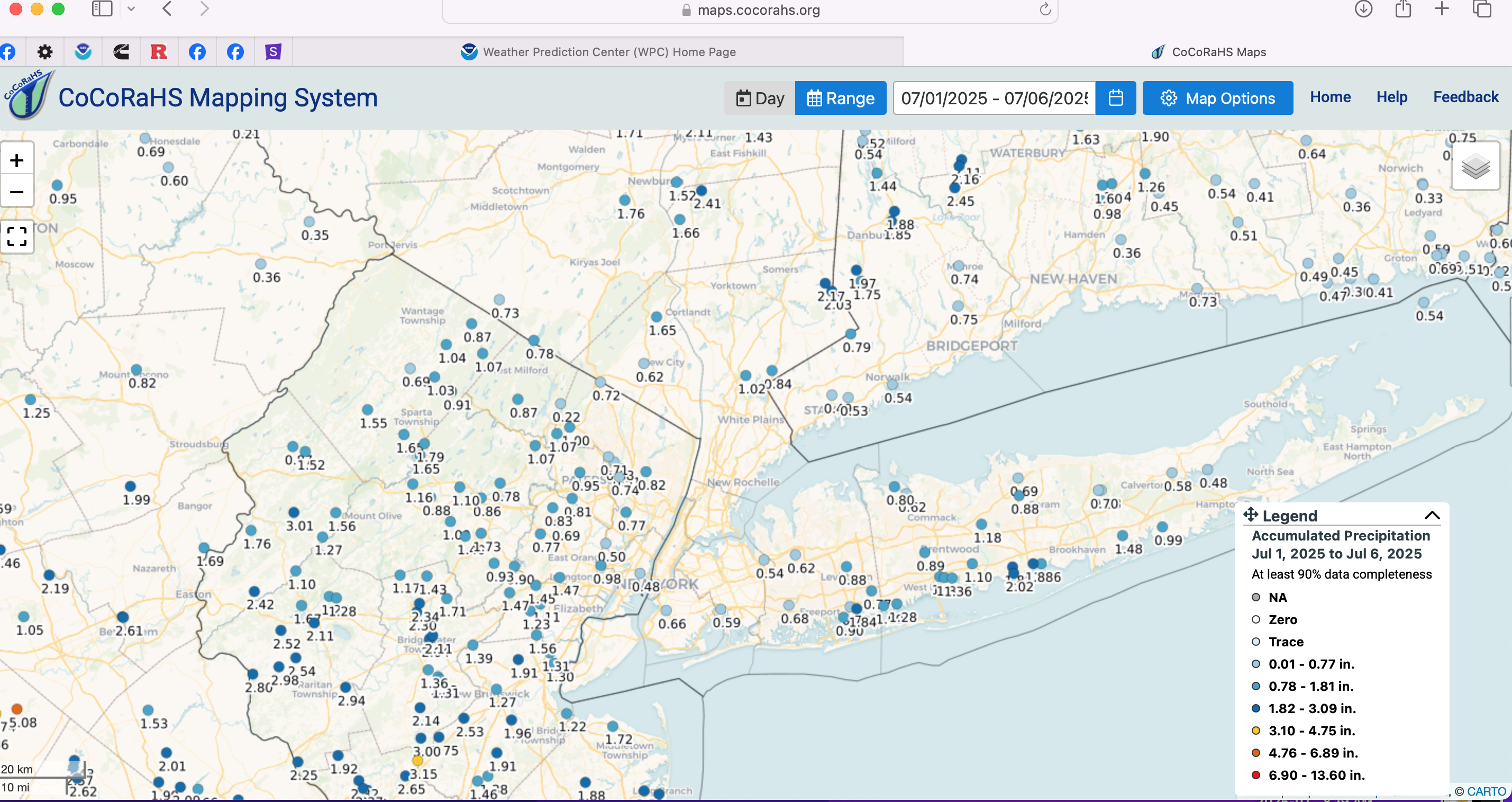
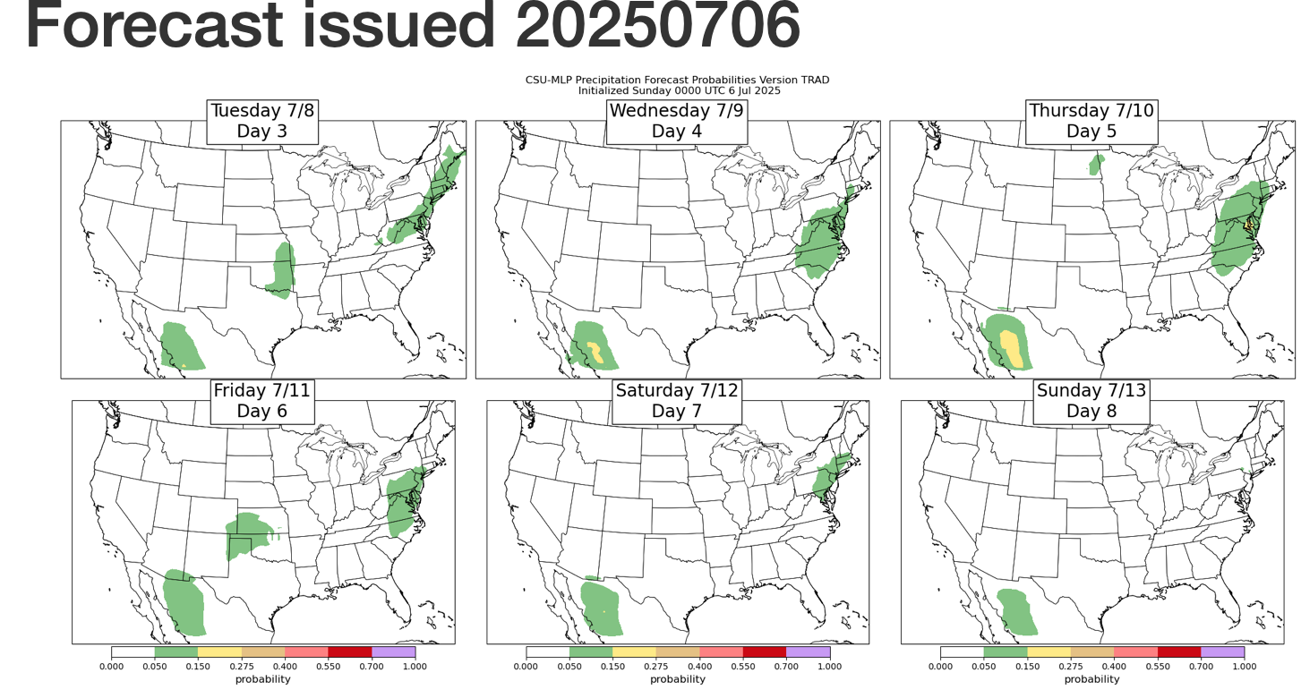
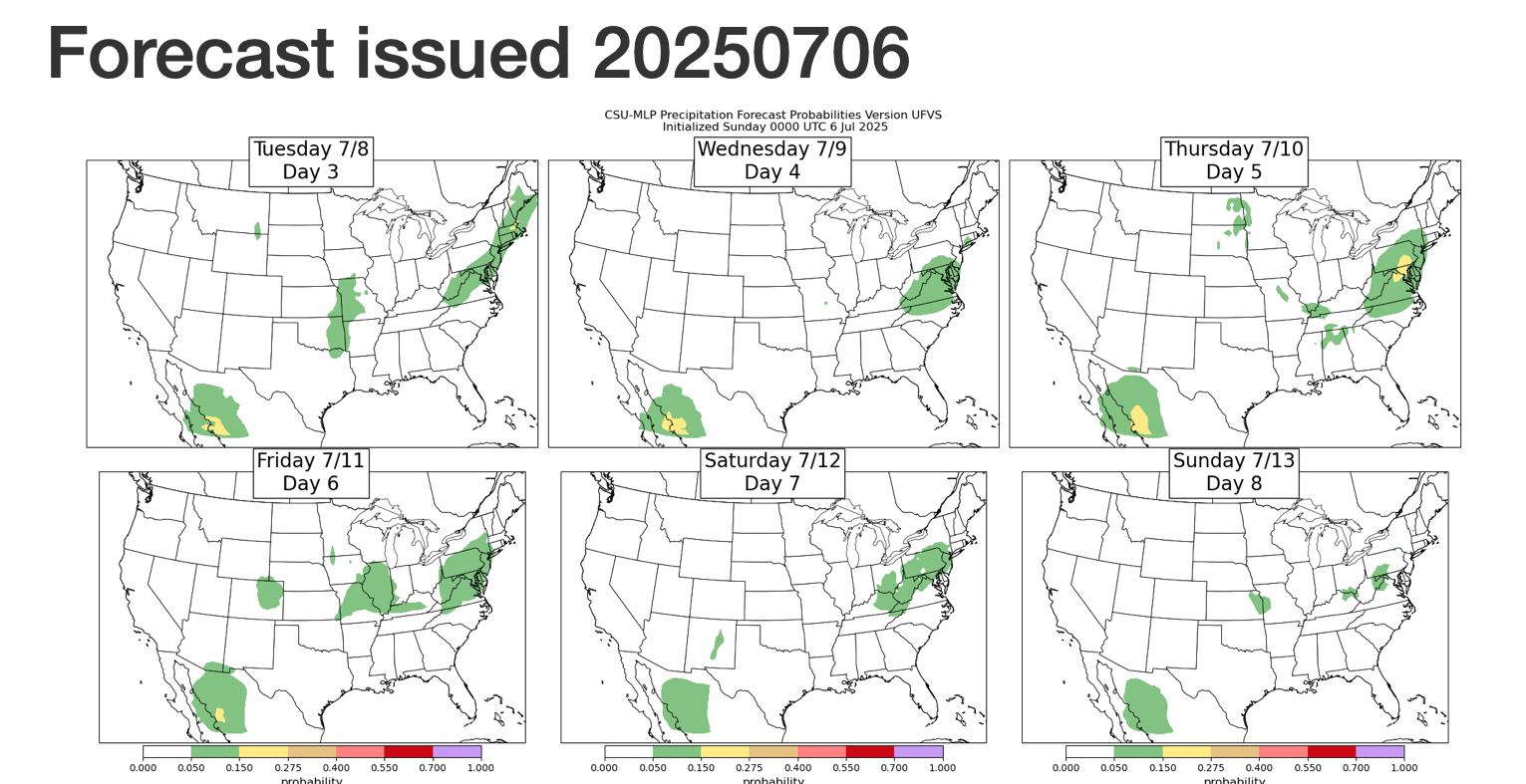
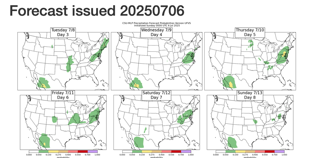
No thread, at least not yet... but the week ahead seems like opportunity for mesoscale excesses. Many models disagree with the EPS (and occasionally the CMC suite) ever increasing heavy rain threat for parts of our NNJ portion of the NYC subforum. For now will go with 3" max Mon afternoon-evening somewhere up here-probably near I95. (Chantel 850 flow-moisture advection combined with RRQ of th UL jet over New England) Looking ahead...the CF heavy convection in parts of the area Tue. Then Thu-Fri, maybe Sat... heavy rain potential with southern stream short wave and warm front returning. Some of the experimental modeling has us in small chance iso FF THU-Sat (spot 5"+ this 3 day period). Added July CoCoRaHs totals as a baseline. Click for clarity. Next potential 3 day (dry) haying period around 7/16-19? Cleaned up the FF potential graphics at 752AM

-
Sure looks like this week will bring ample opportunity for wetness.