All Activity
- Past hour
-
@Solution Man‘s analog still holds strong, lotta young ones.
-
9” by 1 pm Sunday in Baltimore on the ICON lol. What a run
-
NWS grid forecast for DC has “snow” at 80% Saturday night and Sunday… don’t know the last time I’ve seen such a high pop this far out.
-

January 25-26 Winter Storm Potential
Albedoman replied to Ralph Wiggum's topic in Philadelphia Region
the media pressure will be too much or model agreement will have to be stupendous and overwheelming once the GFS comes on board. I am concerned with the severe cold afterwards not the amounts of precip. You have an entire generation of drivers that have never driven on powdery snow that is compacted into 4 inches of solid ice with no salt to melt as temps in the single digits. The region better keep the truck drivers off the interstates or we all see 100 car pileups. As an old timer, this situation with the cold though not as severe as 1994 reminds of one thing friends Just look at where everything is lined up in this weather channel video see below The 1994 ice storm (specifically the January 7–8 event) effectively paralyzed the Lehigh Valley, turning routine travel and daily activities into significant hazards. Transportation Impacts Road Closures and Accidents: Freezing rain transformed roads into "ice skating rinks," leading to hundreds of accidents across southeastern Pennsylvania. A notable 16-vehicle pileup occurred on westbound Interstate 78 in Lower Saucon Township due to the sudden icing. Stranded Vehicles: Many motorists were forced to abandon cars on snow- and ice-covered highways. Public transit, including some Greyhound bus services, was suspended, leaving travelers stranded at terminals. Public Transit Standstill: Regional transit systems like SEPTA and Amtrak faced major delays or complete shutdowns, with some services taking nearly a week to return to normal. Airport Disruptions: Lehigh Valley International Airport (then ABE) and other regional hubs like Philadelphia International faced multi-day closures due to icy runways. Impacts on Daily Life Widespread Power Outages: Heavy ice accumulation—up to 1 inch—downed thousands of trees and utility lines. Approximately 400,000 to 590,000 customers in the broader region lost power, with many remaining in the dark for over a week. School and Business Closures: Schools across the Lehigh Valley were closed for multiple days. In some instances, schools that attempted to open had to send students home early as conditions worsened, leading to buses becoming stranded on rural roads. Supply Shortages: Panic buying led to severe shortages of staple items; locals reported that "not a loaf of bread" could be found in some city stores. Hardware stores quickly sold out of generators, kerosene, and salt. Hazardous Conditions: Falling tree limbs and "snapping" sounds like gunshots were common as the weight of the ice became too great for trees to bear. Walking outdoors became extremely dangerous due to the thick coating of ice on sidewalks. Infrastructure Failures: The extreme cold and heavy precipitation during this period contributed to the eventual collapse of the Corporate Plaza building in Allentown due to a massive sinkhole -
I have a flight to a conference in Vegas on the morning of February 23. Doesn't really apply to this discussion...just thought I'd mention it.
-
Was just going to post this. HP was slightly weaker this run. ICON is heavy snow at 9 degrees out this way. Amazing run.
-

January 2026 regional war/obs/disco thread
vortex95 replied to Baroclinic Zone's topic in New England
That's when Machester-by-the-Sea had the weenie OES 23"? -
Storm is still going at this point too
-
Saving 0s and 1s for Minesweeper games in the off hours. That's just science.
-
Today we start to cross the HR120 (D5) threshold. Should see the guidance really tighten up over the next 24 hours. Would caution folks here that might result in some extreme solutions getting eliminated and thus, reducing a mean snowfall here or there. That does not mean this is "trending towards a bust", but rather just narrowing towards a better forecast.
-
Hey all, I'm here to add to the barrage of teenagers (HS, I'm roughly between @bncho and @Nomz). Been heavily lurking for about a year but I'm so hyped for this storm I finally decided to post. My APUSH teacher had some sage advice for my class today that I'll share here: "don't get too excited, the energy warms up the atmosphere." lol. Let's reel this one in!
-

Pittsburgh/Western PA WINTER ‘25/‘26
colonel717 replied to Burghblizz's topic in Upstate New York/Pennsylvania
Now that there is a consensus of a storm this weekend, models are all going to differ up until gametime on how much of the southern vort get absorbed. Gonna affect how north or south it goes. Even if every model shows they all fully absorb it, it only matters what happens at gametime and we won't have that answer any sooner. Time for me to stop getting caught up in every different model and run. Too tiring. -
interesting dynamics on the Icon. WAA is farther north but colder air than 12z just north of it. TYS is 2 degrees colder at 102
-

January 2026 regional war/obs/disco thread
Go Kart Mozart replied to Baroclinic Zone's topic in New England
The 18z Nam. What more can I say. -
Probably supercomputer time being limited. It might be shared with other tasks.
-
For our lower Delmarva / southern MD / VA tidewater folks. Only two 12z Euro AI EPS members have below 10" of snow for Virginia Beach. What an incredibly consistent signal at this range, which is right in the Euro AI EPS's wheelhouse.
-
Yep, mixing was already a given in my mind as climatology says it usually is. I’m just hoping to see at least 50% of the QPF go to snow. Then ideally as little zr as possible but as long as it stays around 0.25-0.5 there should be too many issues. Frankly, none of that feels like too much to ask for. I could be really crazy and be clinging to the all snow GFS solution, but I'd like to think I've matured enough to know better lol
-
I think so. Gets it done (or would get it done), but just a bit differently than at 12z.
-
I mean it's noise, but it's a little better verbatim, though I wonder if this is more just it being a little faster than anything.
-
probably a money issue
-
Icon trying to go Miller B? .
-

January 2026 regional war/obs/disco thread
wxsniss replied to Baroclinic Zone's topic in New England
Agree I've been browsing through NARR there are H5 similarities to Jan 1994 and Feb 2013... it's nice to be in a favorable setup for a change... in the what's-more-important cold vs. qpf debate for optimizing chances, we're rolling with cold for a few weeks and I think we do well -
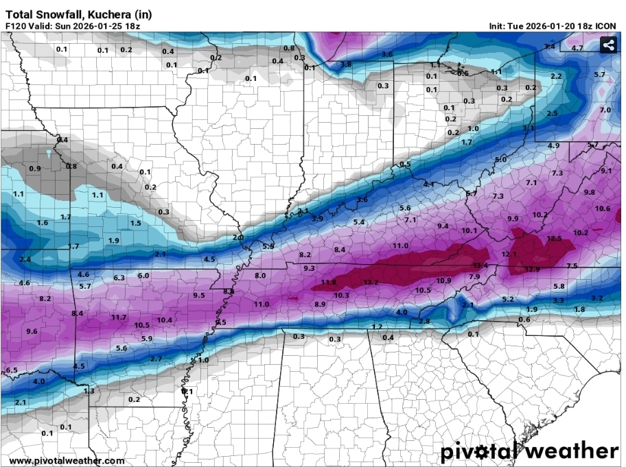
18z ICON
-
Yeah I do not get why some models reduce their run lengths on off hours.
-

Central PA Winter 25/26 Discussion and Obs
paweather replied to MAG5035's topic in Upstate New York/Pennsylvania
Looks like 18z ICON holds serve.


