All Activity
- Past hour
-
Kick this shit out of here so we can beach.
-

Augdewst 2026: Summer's Last Stand
Brian5671 replied to Prismshine Productions's topic in New England
looks dry western sections for sure tomorrow. Cloudy and cool but I'll take it. -
I wasn't home but it looks like 1.8 around my hill. Of course, I got a UPS delivery a few hours before the rain and it's still sitting there because the neighbor forgot to grab it
-
Didn't realize how blessed I was yesterday
-

Central PA Summer 2026 Discussion/Obs Thread
Mount Joy Snowman replied to Voyager's topic in Upstate New York/Pennsylvania
Low of 58 to go along with 1.28" of rainfall. I expect the NWS to confirm a tornado touchdown near the Wrightsville/Columbia area today. Even over my way the low clouds had some serious rotation to them. Impressive event. -
We nearly had a repeat of the August 2025 flash flood last night. It hit Ringgold and Catoosa county instead. 6" of rain in less than 3 hours.
-

Augdewst 2026: Summer's Last Stand
weatherwiz replied to Prismshine Productions's topic in New England
maybe we net some small hailers Sunday -
(002).thumb.png.6e3d9d46bca5fe41aab7a74871dd8af8.png)
Central PA Summer 2026 Discussion/Obs Thread
ChescoWx replied to Voyager's topic in Upstate New York/Pennsylvania
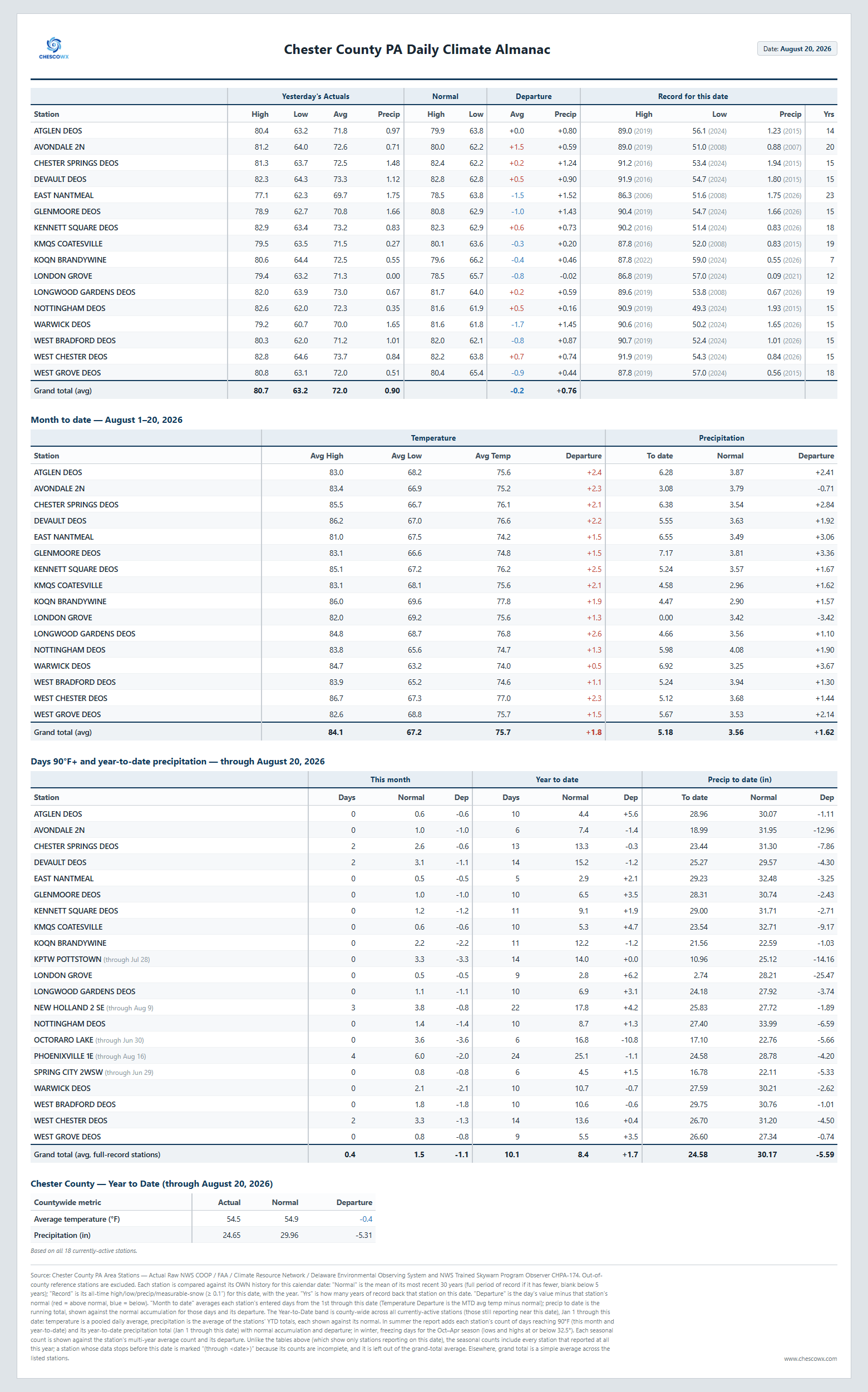
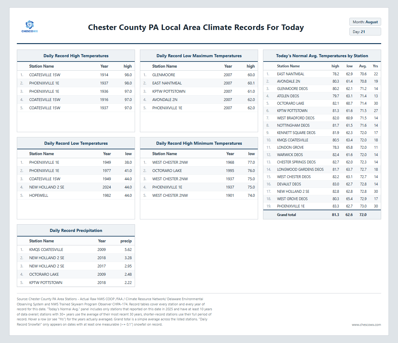
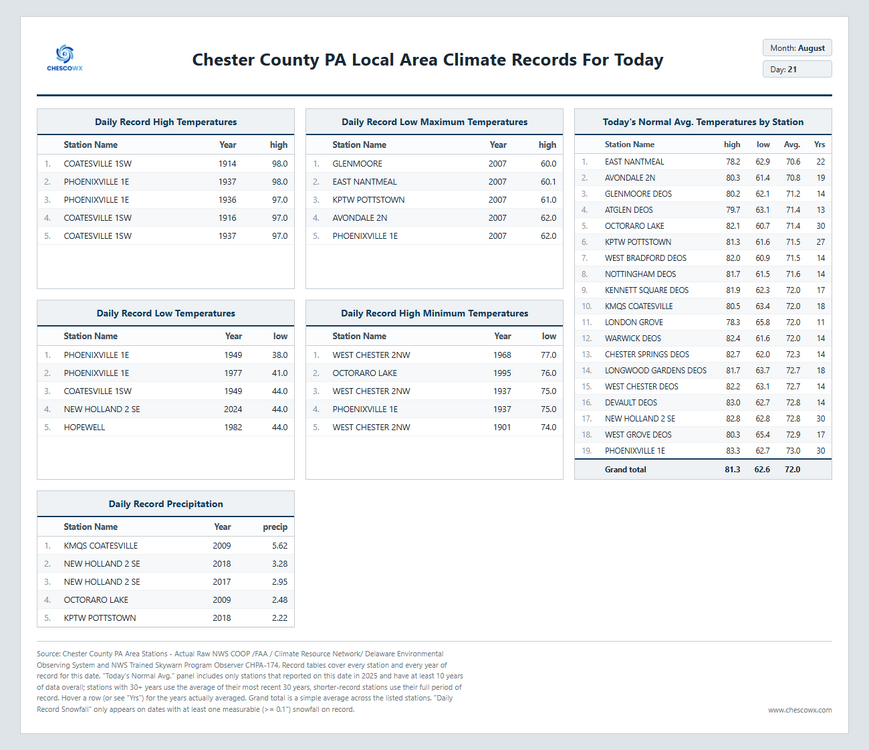
Widespread cool 50's overnight with our usual chilly spot in Warwick Township down to 54.4. In most spots it was our chilliest morning since back on July 26th. Below normal temperatures look likely to continue through most of this week with highs mainly in the 70's and lows in the upper 50's to lower 60's. Some shower chances but no washouts around this weekend before we clear out to start the new work week.
-

Augdewst 2026: Summer's Last Stand
dendrite replied to Prismshine Productions's topic in New England
Mesos had some showers down there most of the day with that low just offshore, but it may be overblown. Looks like the hrrr is backing off a bit this run. Def not a washout. -
E PA/NJ/DE Summer 2026 Obs/Discussion
ChescoWx replied to PhiEaglesfan712's topic in Philadelphia Region
Widespread cool 50's overnight with our usual chilly spot in Warwick Township down to 54.4. In most spots it was our chilliest morning since back on July 26th. Below normal temperatures look likely to continue through most of this week with highs mainly in the 70's and lows in the upper 50's to lower 60's. Some shower chances but no washouts around this weekend before we clear out to start the new work week.
-

2026-2027 Record-breaking El Nino
Typhoon Tip replied to Stormchaserchuck1's topic in Weather Forecasting and Discussion
Oh, that looks like a smoking gun for CC adaptation in that temperature outlook. Not sure ... is that a straight model to publication? - or is it modified by forecaster(s) opinion en route to the public Because it looks damn well like they took the canonical linear El Nino correlation and then just moved it warmer by a click or two. So instead of warm north cool south, you end up with very warm north and more neutral/average S. If. so... can't see I blame them. I mean, we play this head game in here as responsible weather and climate minded people, where we are not deniers about CC ... we just play some avoidance and hedge away from it meaning warmer snow challenging winters ...haha. At least a reticence to do so. Anywho they don't have that luxury. They necessarily need to be as close to accurate as they can be. -
The worst kind. Can't plan anything effectively.
-

Augdewst 2026: Summer's Last Stand
CoastalWx replied to Prismshine Productions's topic in New England
Tomorrow night certainly could rain. -
61.0 for the low. Plenty of upper 50s in Maryland. Looking forward to Monday/Tuesday of next week for more of this.
-

Augdewst 2026: Summer's Last Stand
Damage In Tolland replied to Prismshine Productions's topic in New England
Sun coming out . Should be a nice day -

Augdewst 2026: Summer's Last Stand
tamarack replied to Prismshine Productions's topic in New England
Cloudy weekend, just enough rain to keep the bushes wet but far too little to water the garden. Lose-lose. -
Augdewst 2026: Summer's Last Stand
CoastalWx replied to Prismshine Productions's topic in New England
Basically no models show that -
For years my backyard has died out and I've always blamed myself for not keeping up with watering. Well, despite the crappy early season I did keep the yard in reasonable shape only to conclusively determine that it has been dying out due to dog pee. At this point, with two big dogs, I view much of the yard as an annual and re-seeding is just part of the game.
-

Augdewst 2026: Summer's Last Stand
NoCORH4L replied to Prismshine Productions's topic in New England
BOX is still saying tomorrow is basically a washout to the NH border in all their posts and AFD. Doom and gloom -
Augdewst 2026: Summer's Last Stand
Damage In Tolland replied to Prismshine Productions's topic in New England
Look at the posts source -
Augdewst 2026: Summer's Last Stand
CoastalWx replied to Prismshine Productions's topic in New England
Maybe Saturday night or Sunday morning. -
3.70” storm total, 6.60” for the month.
-

Augdewst 2026: Summer's Last Stand
TauntonBlizzard2013 replied to Prismshine Productions's topic in New England
Right, so what is that post talking about? Looks cloudy and dry for the weekend -
Augdewst 2026: Summer's Last Stand
CoastalWx replied to Prismshine Productions's topic in New England
Tomorrow looks decent. May be tough to clear clouds but looks dry. -
0Z UKMET has 2 ATL TSs: -it has a TS form in the MDR early next week that then moves WNW: NEW TROPICAL CYCLONE FORECAST TO DEVELOP AFTER 102 HOURS FORECAST POSITION AT T+102 : 12.4N 20.3W LEAD CENTRAL MAXIMUM WIND VERIFYING TIME TIME POSITION PRESSURE (MB) SPEED (KNOTS) -------------- ---- -------- ------------- ------------- 1200UTC 25.08.2026 108 12.9N 22.2W 1007 30 0000UTC 26.08.2026 120 13.7N 26.0W 1008 33 1200UTC 26.08.2026 132 13.1N 30.9W 1003 37 0000UTC 27.08.2026 144 12.8N 34.7W 1002 36 1200UTC 27.08.2026 156 13.0N 38.3W 1002 36 0000UTC 28.08.2026 168 14.0N 42.6W 1005 38 ———— -It has a TS form in the subtropical region: 0Z UKMET NEW TROPICAL CYCLONE FORECAST TO DEVELOP AFTER 54 HOURS FORECAST POSITION AT T+ 54 : 29.9N 58.5W LEAD CENTRAL MAXIMUM WIND VERIFYING TIME TIME POSITION PRESSURE (MB) SPEED (KNOTS) -------------- ---- -------- ------------- ------------- 1200UTC 23.08.2026 60 30.4N 59.0W 1015 25 0000UTC 24.08.2026 72 31.2N 59.5W 1015 28 1200UTC 24.08.2026 84 32.6N 60.2W 1013 33 0000UTC 25.08.2026 96 34.9N 59.6W 1012 30 1200UTC 25.08.2026 108 37.7N 58.5W 1007 36 0000UTC 26.08.2026 120 41.7N 55.6W 1003 44 1200UTC 26.08.2026 132 46.8N 50.7W 1000 43 0000UTC 27.08.2026 144 51.0N 42.4W 999 40 1200UTC 27.08.2026 156 53.5N 34.1W 996 33 0000UTC 28.08.2026 168 POST-TROPICAL