All Activity
- Past hour
-
Yep, just make sure you check to make sure there’s no CAPE or thunderstorm potential. Oh and always approach from the top as I tried going bottom up once and the bridge was washed out
-

January 2026 regional war/obs/disco thread
dendrite replied to Baroclinic Zone's topic in New England
WTTTE -

January 2026 regional war/obs/disco thread
weatherwiz replied to Baroclinic Zone's topic in New England
BOS perhaps gets near 50F with 40's elsewhere...but temperatures start dropping west-to-east through the afternoon...probably see squalls along the leading edge of the colder air -

January 2026 OBS and Discussion
coastalplainsnowman replied to TriPol's topic in New York City Metro
Memories of this classic:
-
47° here. I remember last week people were saying one day mild up.
-
January 2026 regional war/obs/disco thread
dendrite replied to Baroclinic Zone's topic in New England
I like big cold…I just worry about my birds and plants. There’s just something about going out in a calm -20° or colder airmass and breathing it in. 0°F is cold, but when you push -30 it’s on another level. -

Winter 2025-26 Short Range Discussion
Chicago Storm replied to SchaumburgStormer's topic in Lakes/Ohio Valley
to be clear, i’m not hating on the lead up… few to none got that right. i’m hating on the in the moment. -

January 2026 regional war/obs/disco thread
40/70 Benchmark replied to Baroclinic Zone's topic in New England
The persistent +WPO portion has obviously started to shift already, and the behavior of the MJO will eventually follow suite.....but that is lagging, which is at least part of the reason why we still have a dearth of large east coast storms despite a N Pac more conducive to cold...also some plane bad luck, I'm sure. -
It’s the extreme range NAM but it was very similar to the 6z Euro. Looked like it was about to go boom if it went out 6 more hours.
-

January 2026 regional war/obs/disco thread
jbenedet replied to Baroclinic Zone's topic in New England
40/34 We torch since the 6th scattered snow cover gone today. -
January 2026 regional war/obs/disco thread
dendrite replied to Baroclinic Zone's topic in New England
I don’t think anyone had DD from that airmass in SNE. Wasn’t it really windy? I remember ORH doing -10° or something in that. DD is basically the frozen form of fog…a cirrus cloud at the sfc. -

January 2026 regional war/obs/disco thread
radarman replied to Baroclinic Zone's topic in New England
I've refrained from chiming in lately but the fact is you have to play the hand you're dealt. If we had super snowy and warm we'd be skiing. If we had early Jan 2007 we'd be out taking walks. Of those who complain most bitterly I'm not sure they've ever posted evidence of going outside in the winter in any conditions. The south beckons. -
That's pretty wild. Looks like a total of only 6 out of 34 happened earlier than January 15.
-

January 2026 regional war/obs/disco thread
Damage In Tolland replied to Baroclinic Zone's topic in New England
Nah 50-55 -
Why? Just because in some areas it went from 50 inches to 3 inches in a six hour period? It's trying to give you every option possible. Maybe the 12 Z will show a heat wave today just to open up all possibilities.
-
Do you understand why the change happened and why it has happened in the past many times ?
-

January 2026 regional war/obs/disco thread
RUNNAWAYICEBERG replied to Baroclinic Zone's topic in New England
We are ready. -
If Raleigh gets a 6” storm this year I promise we’ll send everything else your way the rest of the the season
-
Totally agree, I think if you look at ens. right now on both GFS and Euro, go right in the middle of the heaviest predicted totals and that's where we will see bulk of the storm. I hate being on the outskirts, but that's what it's looking like. Need some blocking, get that wave slowed down and developed more then we would be game. Also, the NAM will save us at some point!
-
January 2026 regional war/obs/disco thread
40/70 Benchmark replied to Baroclinic Zone's topic in New England
Well, the gradient between the stagnant cold over Siberia and warmth east of Japan not only accentuates the jet, but emphasizes the n PAC placement ...it goes hand-in-hand. That is starting to change... The Limitation of Traditional Conceptualizations In A Warming Climate The Relative Ocean Nino Index (RONI) attempts to remove the trend due to global warming in an effort to produce a measure that is of more direct relevance to changes in tropical convection driven by SST anomalies, rather than the general warming around the globe. This is similar to the issues addressed with respect to the original PDO patterns in that the general background warming alters these traditional relationships. Just as the west Pacific warm pool enhances the general cold phase of the Pacific despite the general warming along the coast of the western CONUS, it also strengthens the proclivity for the MJO to frequent the MC in a similar fashion to canonical La Nina despite any competing forces. In this case, the competing force is perhaps some heightened convection and vertical ascent in the vicinity of the dateline relative to what would normally be expected for a cool ENSO event. Thus it is probably unreasonable to expect as consistently of a cold pattern as seen in an older analog, such as 1995-1996, due to the increased baseline tendency for MC forcing and Pacific jet extensions. Note the absence of subsidence in the vicinity of the dateline in the traditional weak and east-based La Niña composites. However, the most recent weak and east-based events are not devoid of this Modoki like subsidence in this area, rather it is just more subdued. This is indicative of considerable periods of MC forcing and Pacific jet extensions, albeit less propounded than in a canonical La Niña that is more west-based. This is also illustrated by the aforementioned increase in the Pacific jet over time. How this manifests in terms of the RONI is that these modern La Niña events often have stronger RONI values due to the west Pacific warm pool accentuating the cool ENSO influence. This is what feedbacks into the pattern that reenforces the cold over Siberia and warmth east of Japan that embodies the +WPO regime, and strengthens the jet. Below is the progression over the past quarter of a century in the north Pacific relative to the intensity of the Aleutian low, as the attendant Hadley Cell has continued to expand northward. Note that this western Pacific warmth was less pronounced in the older La Nina analog composite, which is why the jet was weaker in the mean. -
(002).thumb.png.6e3d9d46bca5fe41aab7a74871dd8af8.png)
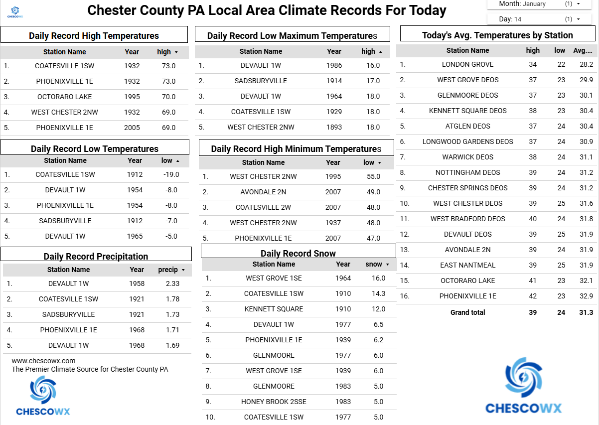
Central PA Winter 25/26 Discussion and Obs
ChescoWx replied to MAG5035's topic in Upstate New York/Pennsylvania
Of note today back in 1912 Chester County recorded its lowest temperature on record of 19 degrees below zero at Coatesville 1SW. This was equaled at Phoenixville 1E (1/22/61) and Octoraro Lake (1/22/84.) Nothing close to that today here in Chesco...however our coldest weather of the season will arrive next week. This is also on average our coldest week of the year. We could see some light rain both today and especially later tonight this may change to a bit of light snow toward tomorrow morning which could make for some slippery spots for rush hour. Temperatures tomorrow will fall through the 20's during the day. We stay below freezing on Friday but moderate a bit with a bit of snow possible on Saturday with the arrival of the arctic front. Next week will feature well below normal temperatures.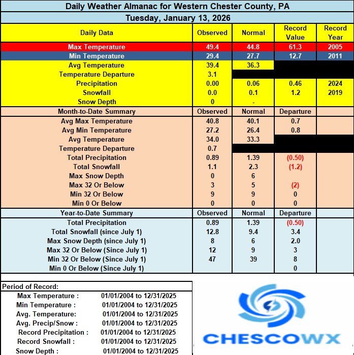

-
January 2026 regional war/obs/disco thread
dendrite replied to Baroclinic Zone's topic in New England
That was more of a shallow cold. 850s were relatively warm. 04 had -25C 850s in S NH with snowfall. -
E PA/NJ/DE Winter 2025-26 Obs/Discussion
ChescoWx replied to LVblizzard's topic in Philadelphia Region
Of note today back in 1912 Chester County recorded its lowest temperature on record of 19 degrees below zero at Coatesville 1SW. This was equaled at Phoenixville 1E (1/22/61) and Octoraro Lake (1/22/84.) Nothing close to that today here in Chesco...however our coldest weather of the season will arrive next week. This is also on average our coldest week of the year. We could see some light rain both today and especially later tonight this may change to a bit of light snow toward tomorrow morning which could make for some slippery spots for rush hour. Temperatures tomorrow will fall through the 20's during the day. We stay below freezing on Friday but moderate a bit with a bit of snow possible on Saturday with the arrival of the arctic front. Next week will feature well below normal temperatures.
-
Models really lost the storm signal around the 24th big time. They were honking on it yesterday but now…. Nothing. I’m sure something will reappear at some point because the pattern is conducive. But wow what a change in a 6 hour model run period !
-

Winter 2025-26 Short Range Discussion
RCNYILWX replied to SchaumburgStormer's topic in Lakes/Ohio Valley
For those who prefer not to bash given the challenges of these, there was a debate in the office when I was about to leave re. SQW. It's not as simple as just pushing a button. There's a specific criteria for visibility of less than one quarter mile that wasn't really being met at the ob sites as the squall moved through areas farther north. For that reason, there was active discussion including Gino Izzi (lead forecaster), our WCM, and the other lead that had just arrived on the best way to handle things. I personally weighed in on the side of issuing a SQW for downstream areas right before I left. From a lead time perspective, I'm happy I put out a SPS at 4:50am when it wasn't exactly clear how it would go and a graphic heads up. We also made a social media post last njght that gave a heads up. I thought something like this might be possible, if you read back to AFDs from past few early mornings, but this definitely overperformed and has been a top tier squall for this area. Ultimately, yes, we could have issued a SQW earlier that included the rest of the metro, but I think we gave a heads up about adverse conditions and got some lead time with the SQW for the south burbs and points south and east. For very tough forecasts, you win aspects of it, lose some, and learn and apply it to future similar scenarios. Thankfully the roads weren't too bad for most of my drive back home - only starting getting worse traction once almost into Naperville from north Bolingbrook. Edit: I guess the app really didn't like me trying to type out less than one quarter mile visibility with a less than symbol and numbers lol