All Activity
- Past hour
-
1.39”
-
0.13” yesterday. Not nearly enough but better than 0
-
Channel 7 showed a rainfall graphic this morning showing parts of the city, LI, and Jersey south of I78 got very little out of this event compared to areas to the north. Two rounds of storms passed through my area of Queens yesterday afternoon for a storm total of 0.57".
-
We can't be QPF pigs, just take what you get.
-
 1.06 yesterday at a nearby PWS. I'm fine with that. No need for flooding.
 -

Central PA Summer 2026 Discussion/Obs Thread
pawatch replied to Voyager's topic in Upstate New York/Pennsylvania
65 degrees this morning. Yesterday was a big disappointment for rainfall. As much as they was warning everyone of severe weather. .20” was all I got. The 2nd storm the radar just dissipated, and we didn’t even get a trace of rain. The river they went from predicting a crest of around 6’ to the river cresting below 3’. Currently a 1.46 deficit of rain for the month of July. June was even worse. -
Only 0.15" in Lindenhurst yesterday, 5.45" for the month
-
Maybe somebody's drone shaped that way.
-

E PA/NJ/DE Summer 2026 Obs/Discussion
BBasile replied to PhiEaglesfan712's topic in Philadelphia Region
Time lapse of couple shelf clouds from yesterday. Not much happened, otherwise. Ended up with 0.63" of rain. -
E PA/NJ/DE Summer 2026 Obs/Discussion
BBasile replied to PhiEaglesfan712's topic in Philadelphia Region
-
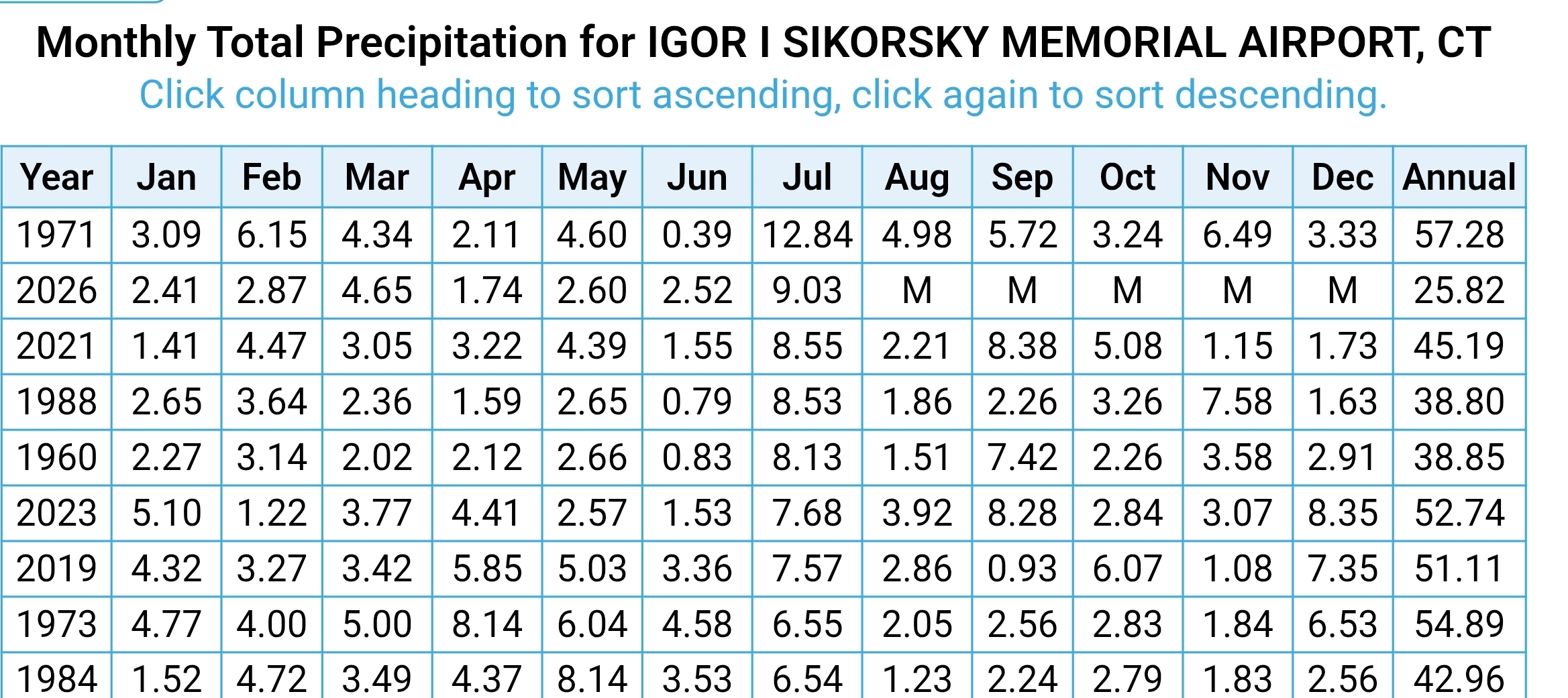
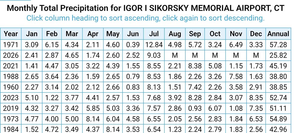
 Just incredible rain here this month. Just standing water and mushrooms everywhere. 2nd wettest July at BDR with 9.03 inches.
.thumb.png.a5a8a75ae8ebb7e29a90e71c98f2da61.png)
-
This was my heaviest rainfall in an hour since moving up to CT. Picked up 3.18 yesterday from around 1:50 to 2:50 PM. The daily total in my area was 3.72.
-
 Hartford plus 1.2 for the month. Doesn't seem like that would be the hottest ever???
 -

Central PA Summer 2026 Discussion/Obs Thread
Mount Joy Snowman replied to Voyager's topic in Upstate New York/Pennsylvania
Low of 69 with a paltry .01” of rain. Just too much cloud debris around yesterday to ever really get things going. Good news is the upcoming stretch of weather is about as good as it gets for late July. Enjoy. -
And there goes Rusty!
-

2026-2027 Super El Nino
bluewave replied to Stormchaserchuck1's topic in Weather Forecasting and Discussion
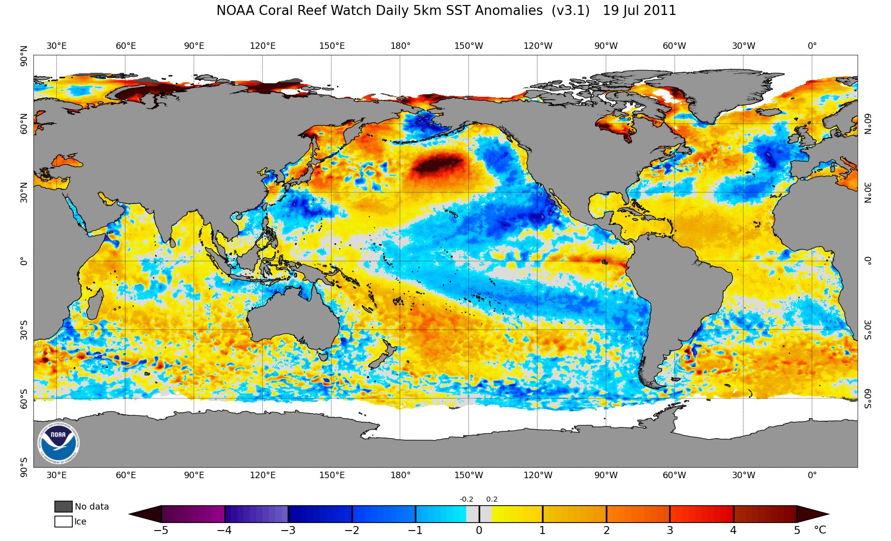
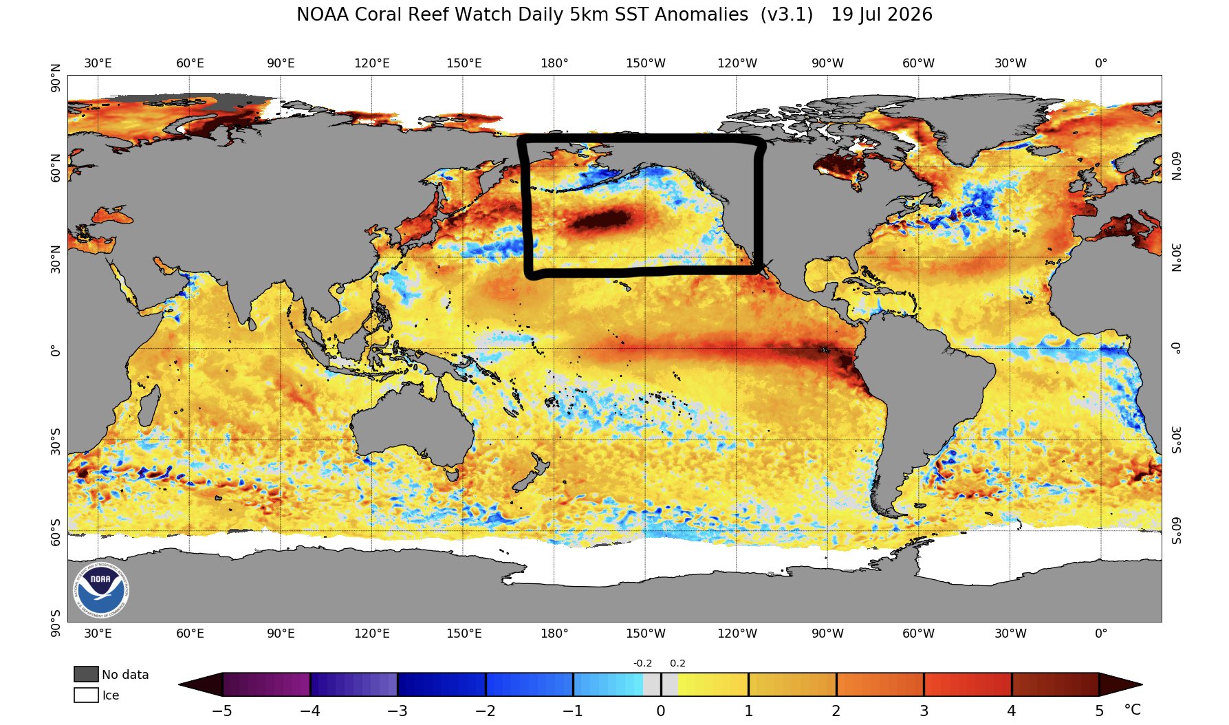
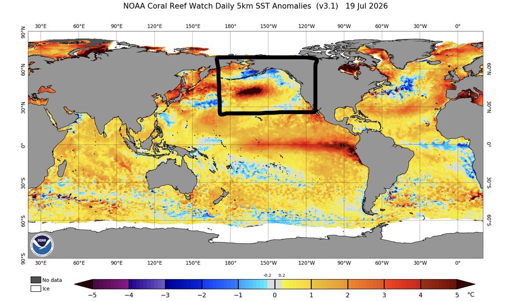
Pretty wild how we have had elements of the summer 2011 weather pattern against the backdrop of such an extreme developing El Nino. Maximum 1-Day Mean Max Temperature for HARRISON, NJ Click column heading to sort ascending, click again to sort descending. 1 107.0 2011-07-22 through 2011-07-22 2 106.0 2026-07-03 through 2026-07-03 - 106.0 2010-07-06 through 2010-07-06 3 104.0 2001-08-09 through 2001-08-09 4 103.0 2026-07-04 through 2026-07-04 - 103.0 2025-06-25 through 2025-06-25 - 103.0 2025-06-24 through 2025-06-24 - 103.0 2012-07-18 through 2012-07-18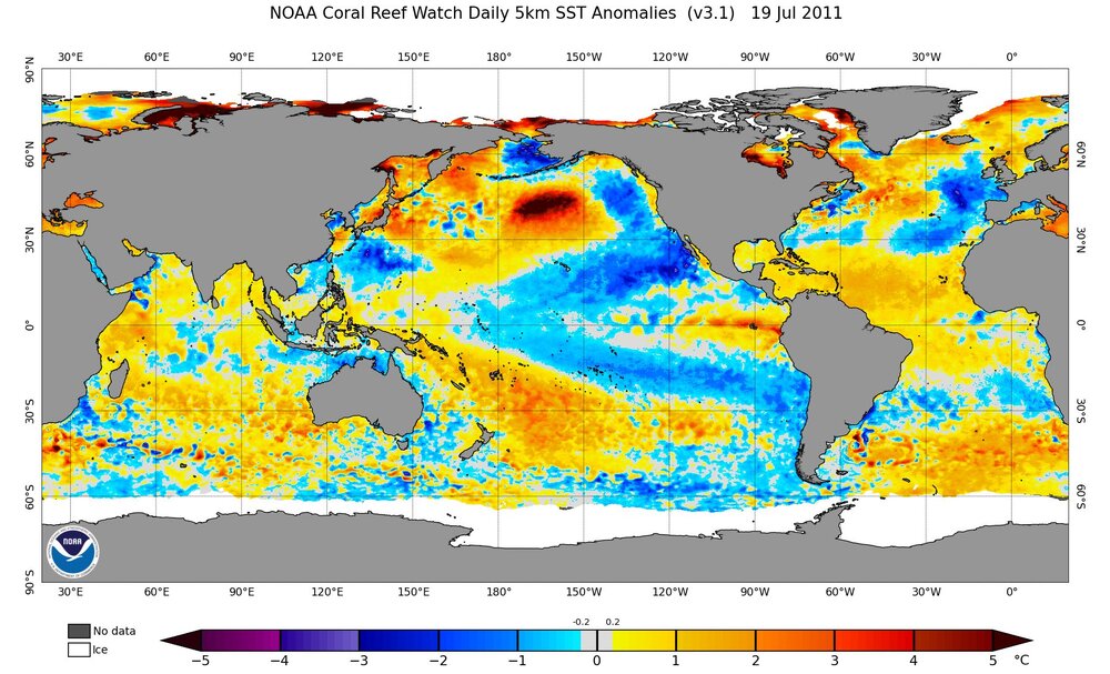
-

2026-2027 Super El Nino
snowman19 replied to Stormchaserchuck1's topic in Weather Forecasting and Discussion
We’ve now passed 1997’s OHC record, we are over +2.6C The Peru weather service just updated, they are expecting “extraordinary” (aka super) El Niño costero (region 1+2) conditions, with SSTs greater than +3.5C to continue into 2027….. Region 3.4 continues shattering SST records -
Upcoming days look like pure chamber of commerce weather. One day of raised dew points and right back to it. Not much sweating this summer.
-
You can always cancel if it looks bad.
-
Picked up 0.89” here, which isn’t as much as I thought. I was in the city last night and they definitely got more.
- Today
-

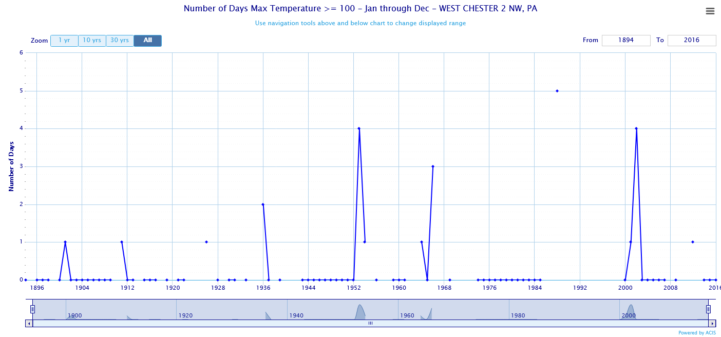
Chester County PA - Analytical Battle of Actual vs. Altered Climate Data
chubbs replied to ChescoWx's topic in Climate Change
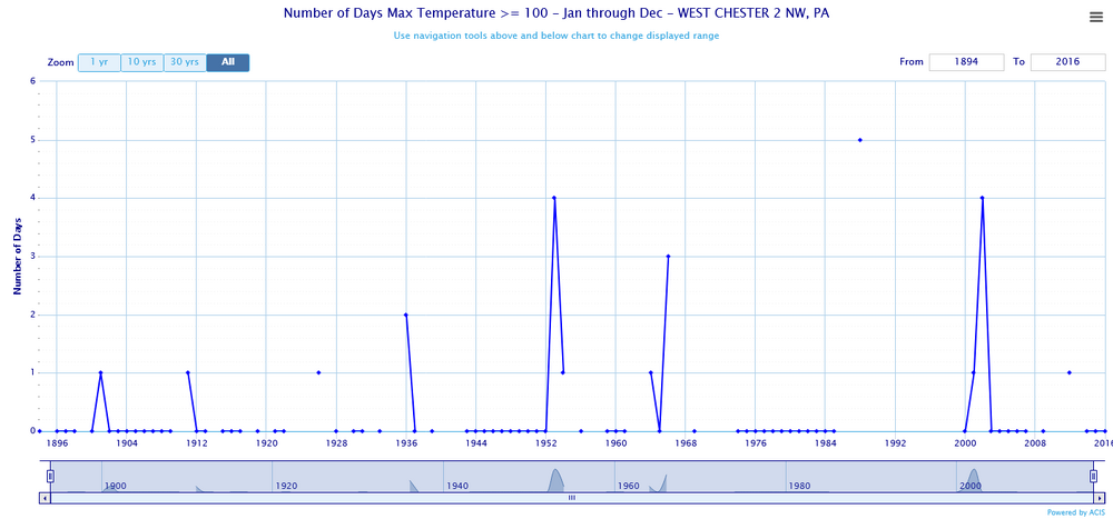
Nope no dust bowl in Chester County, just Phoenixville with a bad shelter location. Philadelphia and West Chester don't agree at all with your plot. Not surprising since once again you are confounding station changes and weather. East Nantmeal and West Grove are a little different than the City of Coatesville or West Chester don't you think?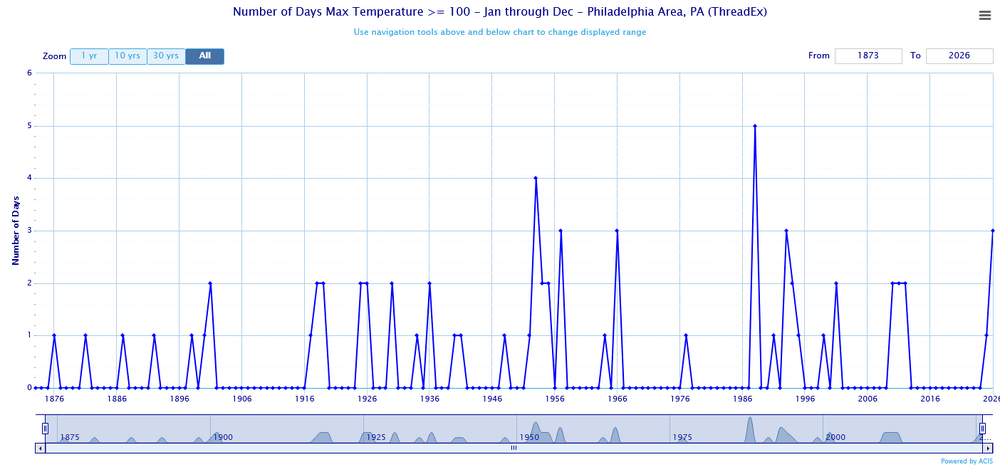
-
Congrats north, south, east, and west of me. .60 here while just about everyone received 3-6". Ugh the boring drought continues in my area. I'm going to have to start chasing rain events. So bored. I can't wait until LES season lol
-
 Pft. 0.34". Sent from my SM-S921U using Tapatalk
 -
 Glad to see we both could get in on the action. I’m a little to your southwest, on the norwell/scituate line. This was def a much needed soaker for the south shore and much of eastern ma too!
 -
 What a deluge of rain this morning in my area of NS. Looks like another heavy slug later this morning also. Certainly not the dry summer we had last year..






.png.3c86979e8c8570f8ee2e5f3f01fe2c9f.png)