All Activity
- Today
-

SE Area of Interest--0% two day, 30% five day odds
GaWx replied to WxWatcher007's topic in Tropical Headquarters
Upped from 20% to 30%: 2. Off the Southeastern United States: A broad area of low pressure is forecast to form in a couple of days a few hundred miles off the coast of the southeastern United States. Some gradual development of this system is possible during the middle or latter part of the week as the system drifts to the west or northwest. * Formation chance through 48 hours...low...near 0 percent. * Formation chance through 7 days...low...30 percent. -
Upped from 40% to 50%: Tropical Weather Outlook NWS National Hurricane Center Miami FL 200 AM EDT Mon Aug 4 2025 For the North Atlantic...Caribbean Sea and the Gulf of America: Active Systems: The National Hurricane Center is issuing advisories on newly formed Tropical Storm Dexter, located over the western Atlantic Ocean. 1. Central Tropical Atlantic: A tropical wave is forecast to move off the west coast of Africa later today. Thereafter, some gradual development of the wave is possible, and a tropical depression could form late this week while it moves generally west-northwestward across the central tropical Atlantic. * Formation chance through 48 hours...low...near 0 percent. * Formation chance through 7 days...medium...50 percent.
-
We’re getting pretty heavy rains at 1AM (8/4) from an area moving only slowly NW. Hopefully, the heavy doesn’t last too long. Edit: It’s not yet letting up at almost 1:30. And this was released at 1AM, a repeat of Saturday: Z.000000T0000Z.000000T0000Z.OO/ CHATHAM GA- 101 AM EDT MON AUG 4 2025 ..FLOOD ADVISORY IN EFFECT UNTIL 3 AM EDT EARLY THIS MORNING * WHAT...FLOODING CAUSED BY EXCESSIVE RAINFALL IS EXPECTED. * WHERE...A PORTION OF SOUTHEAST GEORGIA, INCLUDING THE FOLLOWING COUNTY, CHATHAM. * WHEN...UNTIL 300 AM EDT. * IMPACTS...MINOR FLOODING IN LOW-LYING AND POOR DRAINAGE AREAS. WATER OVER ROADWAYS. OVERFLOWING POOR DRAINAGE AREAS. PONDING OF WATER IN URBAN OR OTHER AREAS IS OCCURRING OR IS IMMINENT. * ADDITIONAL DETAILS... - AT 100 AM EDT, DOPPLER RADAR INDICATED HEAVY RAIN EXTENDING FROM SILK HOPE AND HUNTER ARMY AIRFIELD TO RIO VISTA. A QUICK 1 TO 2.5 INCHES OF RAIN COULD FALL THROUGH 3 AM, RESULTING IN URBAN FLOODING. - SOME LOCATIONS THAT WILL EXPERIENCE FLOODING INCLUDE... POOLER, MIDTOWN SAVANNAH, WINDSOR FOREST, HUNTER ARMY AIRFIELD, COFFEE BLUFF, DOWNTOWN SAVANNAH, HUTCHINSON ISLAND, WILMINGTON ISLAND, I-16/I-95 INTERCHANGE AND MONTGOMERY.
-
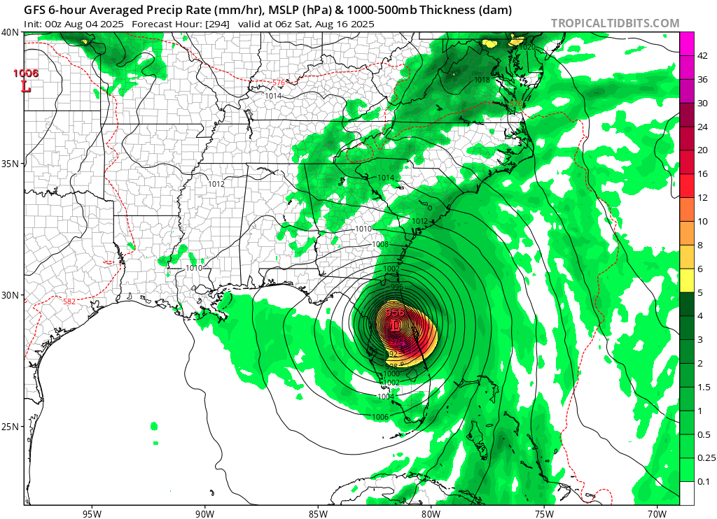
Another Florida hit on gfs

-
 Plenty of people who don’t fish use their boats. Coming from someone at the marina every week…also no sailboaters fish and they are out a lot as well. what keeps people from using their boats is kids sports and bad weather. That’s about it
 -
71 for the high today with around .39 inches of rain. The rest of the week looks pretty good too.
-
After 5 runs in a row with TCG from this (3 in MDR and the last 2 N of the MDR), the new UKMET (0Z) completely dropped this as a TC.
-
Could potentially go 14+ days with no precip. Even with the smoke today, it was beautiful. It definitly has been feast or famine precip wise the past few months. It hasn't rained often but when it has, 3 inches+ has fallen 3 different times in less than a few hours, when rain chances were forecasted at 30%.
-
 Yep, my dad likes to fish and keeps his boat in the water from mid-April through mid-October
 -
pathetic try again next time dexter morgan
-
smoke has been an every summer occurrence for years now.
-

tropical storm dexter
WishingForWarmWeather replied to BarryStantonGBP's topic in Tropical Headquarters
We got Dexter. -
Hi Res NAM shows pockets of 6+
.thumb.png.f933b2001661fea78037946fc374871f.png)
-
Orange skies and sun
-
Won’t be long until 95L is a TC.
-
The air quality and smoke has been something this season. So many hazy orange evenings on the mountain. The sun is just this orange crisp disk in the sky.
-
 Boats are only worth it if you love fishing. Fishing season starts in April and runs through early December. Peole with boats, who don’t fish, barely use them and just waste money.
 -
"do the dew" yes Dr. Dew approved
-
Days shortening quickly now. Christmas is right around the corner, and with the lack of sunlight/short days, it'll FLY by!
-
Dexter coming at 11
-
 Table of forecasts for August 2025 FORECASTER ____________ DCA _NYC _BOS ___ ORD _ATL _IAH ____ DEN _PHX _SEA hudsonvalley21 __________ +1.8 _ +2.1 _ +1.9 ___+1.3 _ +2.2 _ +1.5 ___+1.3 _ +1.2 _ +1.0 wxallannj ________________ +1.8 _ +1.9 _ +2.0 __ +2.2 _ +1.2 _ +2.0 __ +2.8 _+2.8 _ +0.5 RJay ____________________ +1.5 _ +1.7 _ +1.7 ___ +1.8 _ +1.0 _ +1.0 ___ +2.0 _+2.0 _+2.0 Roger Smith _____________ +1.5 _ +1.5 _ +1.8 __ +2.0 _ +2.5 _ +2.8 __ +3.3 _ +2.8 _+3.2 Yoda _____________________+1.4 __+1.1 __+0.9 __ +0.7 _+0.9 _+1.3 ___ +1.1 _ +1.6 _ +1.8 wxdude64 _______________+1.2 _ +1.6 _ +1.8 ___+1.1 __+0.6 _ +0.4 __ +0.9 _ +2.1 _ +1.9 ____ Consensus _________ +1.1 __+1.1 _ +1.0 __ +0.9 _+0.9 _ +1.1 ___ +1.4 _ +1.9 _ +1.7 Scotty Lightning _________ +1.0 _ +1.0 _ +0.5 __ +1.0 _ +1.5 _ +2.0 __ +0.5 _ +1.5 _ +0.5 so_whats_happening ____ +1.0 _ +0.8 _ +1.0 __ +0.9 _ +0.6 _+0.5 __ +1.5 _ +1.8 _ +1.6 Tom ______________________+0.6 _+0.5 _ +0.4 __ +0.2 _ +0.9 _+1.1 ___ +1.2 _ +1.3 _+1.4 DonSutherland1 __________+0.3 _ +0.5 _ +0.6 __ +0.4 _+0.2 _+0.2 __ +1.6 _+2.1 _ +2.2 StormchaserChuck1 _____ +0.2 _ +0.4 _ +0.8 __ +0.4 _+0.1 _ +0.2 __ +2.0 _+2.3 _+2.3 ____ Normal _______________ 0.0 __ 0.0 __ 0.0 ___ 0.0 __ 0.0 __ 0.0 ____ 0.0 __ 0.0 __ 0.0 RodneyS _________________ -1.4 _ +0.3 _ -0.6 __ +0.9 _ -1.5 _ +0.1 ___ +1.8 _ +1.5 _ +1.1 =============== ____ Persistence __________ +1.4 _+2.0 _+1.9 __ +2.1 _ +3.4 _ +1.2 ____ 0.0 _ +1.4 _ +0.8 ______________________________________________________ Warmest and coldest forecasts are color coded (Persistence is not included) ... Normal is coldest for six locations, NYC, ORD, IAH, DEN, PHX and SEA.
 -
Good thing I left Saturday.
-
Crazy how this forest fire season hasn't been worse. We've been so dry here in the Hebgen Basin/Yellowstone area.
-
Nice orange-red smoke moon tonight.


.png.f54445080bf05544db3aee4ab06e703f.png)