All Activity
- Past hour
-
Your call for extreme heat is happening. Very rare to see the Extreme Heat watch issued. Going to be brutal, not to mention the dew points and real feel temps.
-
Seems like 2006 / 2002 progression so far. We'll have to see the extent of the ridge in the 7/8 - mid month period.
-
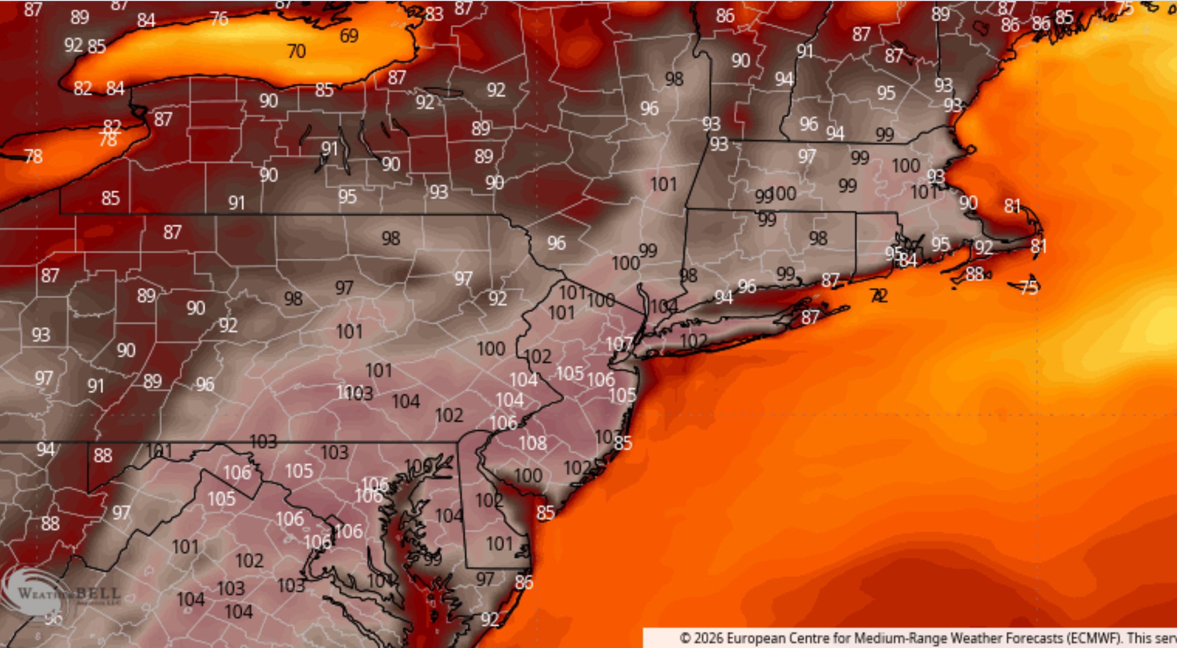
75 / 68 clouds hanging around much of the day but with breaks. Warm / humid low -mid 80swhere the sun comes out most. Trough into the west with snow into the mountains MT - ID - WY and subsequent ridge popping into the Midwest and northeast. Building warmth into record heat 6/29 - 7/5 with core of the heat into the Southeast- Mid Atlantic and NYC-NJ region Wed - Sat. Ridge builds to >594 Dm and 850 MB temps forecast in the >20c by Wed and peaking >22c Thu-Fri. The Fourth of July extended weekend 250th comes in hot blazing Fri-Sat and Sunday - Isolated storms on the euro / more scattered storms on the gfs but for 90% i think it'll be good. A bit of a pull back 7/6 - 7/7 but overall hot beyond with very stong / intense heat nearby and flirting with the eara in the period beyond.
-
I’ll wag BWI and DCA hit 100 twice, but not all time records. IAD gets to 99 or 100 as a max.
-
Oh I think we hit exceptional for sure after July and Aug both less than 1.0 total rainfall and many 100-degree days
-

Junorch obs and discussion 2026
Damage In Tolland replied to Damage In Tolland's topic in New England
Who will hit 110?!? -
Should be banter but anyone having issues with connections to https://www.weather.gov/phi/
-
Finally getting some useless sprinkles this morning. 0.05" for the event! With the big heat on the way and only low probability for showers the end of the week, the monthly total here will be less than 1.5". 4 months straight below avg and only one of those months was above 50% of normal. Exceptional drought category is a possibility. Pretty sure I have never seen that here.
-
Light rain/ drizzle from Brunswick to Frederick this am along with patchy fog. Pleasant surprise, not a drought buster but everything is wet!!!
-
Yeah it’s probably 95-100 or so. You need plume if 24C+ at 850 and crystal clear skies both of which may not happen.
-

Central PA Summer 2026 Discussion/Obs Thread
anotherman replied to Voyager's topic in Upstate New York/Pennsylvania
The lack of rain is very concerning. -
LOL. Another month or so and its finally put out to pasture?
-
Euro clown map for max temp on Friday. I see some 105 to even a 108 in NJ. Sorry, I have been a bit missing in action... Life stuff...

-

Central PA Summer 2026 Discussion/Obs Thread
Mount Joy Snowman replied to Voyager's topic in Upstate New York/Pennsylvania
Low of 68 and a very underwhelming .06” of rainfall. As others have mentioned, things are going to get very dry after we bake out under this extreme heat this week. -
I see Mt. Holly has already issued EHWs... I expect LWX probably will tomorrow
-

2026-2027 Super El Nino
bluewave replied to Stormchaserchuck1's topic in Weather Forecasting and Discussion
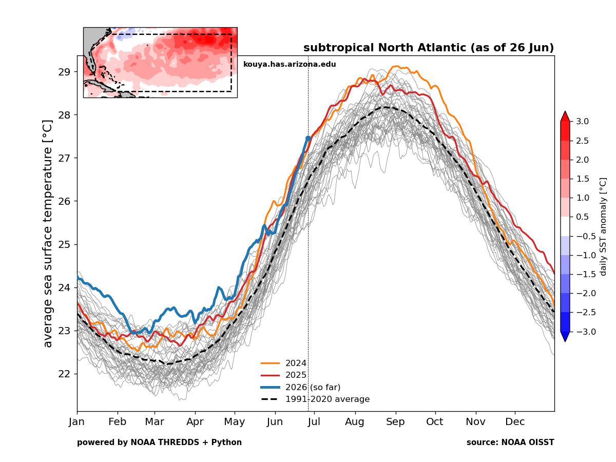
The subtropical North Atlantic is the warmest on record for June 26th.
-
Maybe because its 4th of July weekend and so many people will be out? Go extremely hot and try to get the word out? I mean besides us... I dont think many people are going to care for the difference between 100 and 105.
-
There wasn't any improvement worth mentioning for Falls Lake from yesterday. Looks like today is the last chance for about a week for any real rainfall there. We will see how much it drops off during the net heatwave. At least they lowered my forecast high to 105F for Friday lol.
-
Mount Holly going with 101 and 102 here respectively for Thursday and Friday. Pretty bold. I have never seen 100 here on my station. I will take the under.
-
Classic track. Goated video.
-
The 3km NAM has a couple of 6-7" bullseyes for later today in the area. Of course, it has a 4" one this morning and nobody is getting that, so trust level = low. 0.32" since Friday.
-
For reference:

-
I really don't know what the NWS is thinking by putting 104 and 105 into the zones. You don't forecast historic heat 4-5 days out, especially when the only guidance giving those types of numbers are models that have known boundary layer issues. From the AFD: ================================================================== *** ALL-TIME RECORD HIGHS *** ================================================================== Baltimore 107 (set on Jul 10, 1936) Washington 106 (set on Jul 20, 1930 + Aug 06, 1918) Sterling-Dulles Airport 105 (set on Jul 22, 2011) Baltimore Downtown 108 (set on Jul 07, 2012 + Jul 22, 2011) Annapolis 106 (set on Aug 06, 1918) Hagerstown 105 (set on Jul 14, 1954) Martinsburg 112 (set on Jul 11, 1936) Charlottesville 107 (set on Sep 07, 1954 + 3 other times) ================================================================== *** ALL-TIME RECORD WARM LOWS *** ================================================================== Baltimore 83 (set on Aug 05, 1930 + 2 other times) Washington 84 (set on Jul 24, 2011 + 2 other times) Sterling-Dulles Airport 79 (set on Aug 08, 2007) Baltimore Downtown 88 (set on Jul 02, 2011 and Jul 10, 1993) Annapolis 92 (set on Jul 07, 1994) Hagerstown 86 (set on Jun 15, 1899) Martinsburg 86 (set on Jul 21, 1930) Charlottesville 85 (set on Aug 07, 1918) ================================================================== *** JULY MONTHLY RECORD HIGHS *** ================================================================== Baltimore 107 (set on Jul 10, 1936) Washington 106 (set on Jul 20, 1930) Sterling-Dulles Airport 105 (set on Jul 22, 2011) Baltimore Downtown 108 (set on Jul 07, 2012 + Jul 22, 2011) Annapolis 105 (set on Jul 21, 1930 + Jul 02, 1901) Hagerstown 105 (set on Jul 14, 1954) Martinsburg 112 (set on Jul 11, 1936) Charlottesville 107 (set on Jul 10, 1936 + Jul 20, 1930) ================================================================== *** JULY MONTHLY RECORD WARM LOWS *** ================================================================== Baltimore 83 (set on Jul 21, 1930) Washington 84 (set on Jul 24, 2011 + 2 other times) Sterling-Dulles Airport 78 (set on Jul 24, 2010 + Jul 08, 2010) Baltimore Downtown 88 (set on Jul 22, 2011 + Jul 10, 1993) Annapolis 92 (set on Jul 07, 1994) Hagerstown 83 (set on Jul 24, 2010) Martinsburg 86 (set on Jul 21, 1930) Charlottesville 84 (set on Jul 22, 1930) ================================================================== *** DAILY RECORD HIGHS | WARM LOWS *** VALID: Jul 01 ================================================================== Baltimore 103 (1901) | 80 (1933 + 1901) Washington 102 (1901) | 79 (1977) Sterling-Dulles Airport 96 (2012) | 72 (2017 + 3) Baltimore Downtown 101 (2012) | 82 (2012) Annapolis 103 (1901) | 79 (1945 + 1901) Hagerstown 100 (1901) | 74 (2017 + 1977) Martinsburg 102 (1933) | 74 (1933) Charlottesville 101 (2012 + 1945) | 78 (1901) ================================================================== *** DAILY RECORD HIGHS | WARM LOWS *** VALID: Jul 02 ================================================================== Baltimore 103 (1901) | 80 (1901) Washington 101 (1898) | 79 (2012 + 1872) Sterling-Dulles Airport 98 (1966) | 75 (2022) Baltimore Downtown 102 (1966) | 84 (2002) Annapolis 105 (1901) | 80 (1901) Hagerstown 100 (1966) | 74 (2018 + 1901) Martinsburg 102 (1933 + 1931) | 75 (1933 + 1901) Charlottesville 100 (1954) | 76 (1910) ================================================================== *** DAILY RECORD HIGHS | WARM LOWS *** VALID: Jul 03 ================================================================== Baltimore 104 (1898) | 80 (1898) Washington 101 (1966 + 2) | 80 (2018) Sterling-Dulles Airport 103 (1966) | 73 (2018 + 2) Baltimore Downtown 102 (1997) | 82 (2018 + 1983) Annapolis 100 (1901) | 84 (1896) Hagerstown 102 (1966) | 76 (2002) Martinsburg 102 (1941 + 1911) | 74 (1980) Charlottesville 100 (1966 + 1954) | 79 (1911)
-
Junorch obs and discussion 2026
Damage In Tolland replied to Damage In Tolland's topic in New England
We found Ineedsnow and Kooky Kenny -
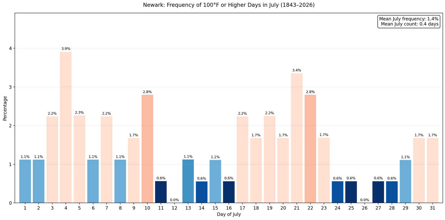
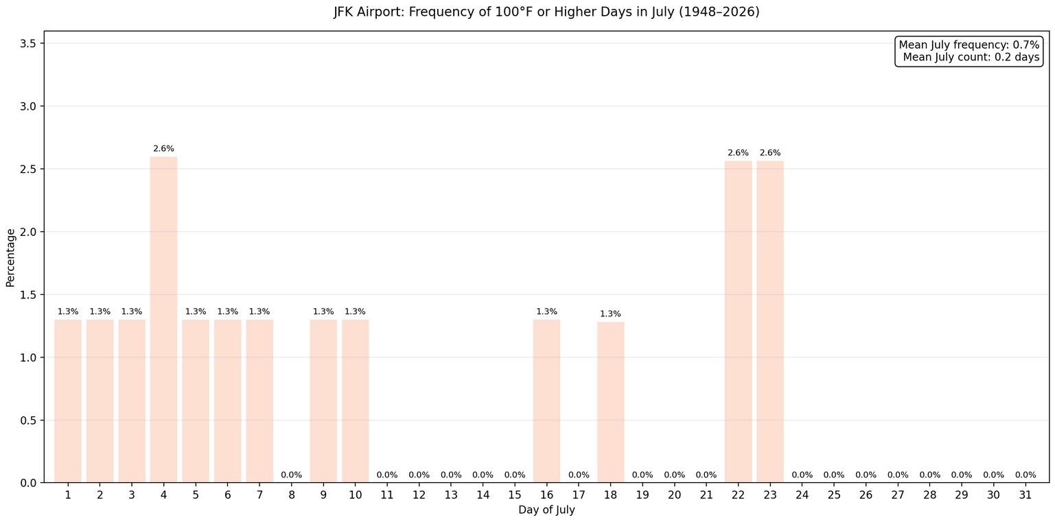
I’m still feeling mostly 98-100 in the hot spots right now…not buying the 2m 103-105 stuff with 850s of only 22-23C. I’m sure EWR will drop a 104° one day over the tarmac though. Just imagine all of those sweathogs in DC later next week for the 250th. No thanks.