All Activity
- Past hour
-
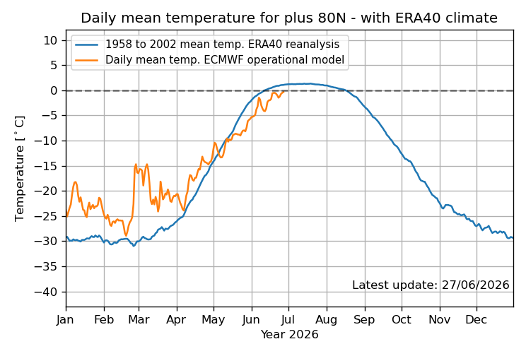
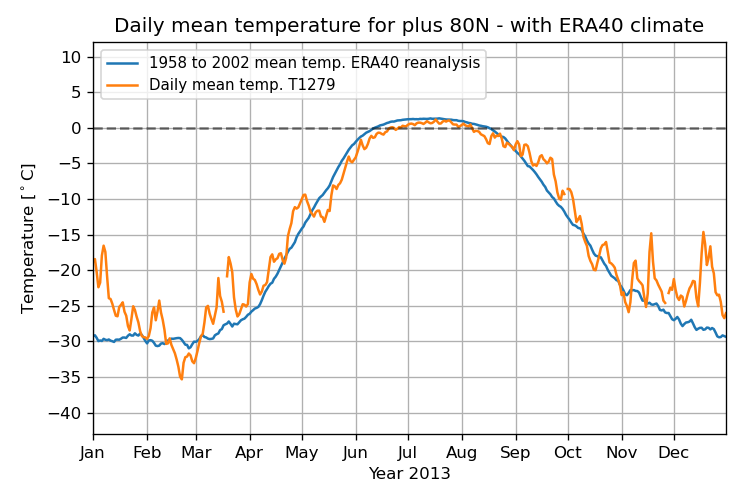
Per DMI, the daily mean temp in the Arctic N of 80N has still not reached 0C! As of today (6/27), it’s still barely <0C at -0.35C: Going all of the way back to 1958, the previous latest to first exceed 0C was a full week earlier, June 20th, and that was in 2013: So, even if it finally exceeds 0C tomorrow, that would still be a whopping 8 days later than the previous latest on record of June 20th! I checked every year. https://ocean.dmi.dk/arctic/meant80n.uk.php
-

2026-2027 Super El Nino
GaWx replied to Stormchaserchuck1's topic in Weather Forecasting and Discussion
Per DMI, the daily mean temp in the Arctic N of 80N has still not reached 0C! As of today (6/27), it’s still barely <0C at -0.35C: Going all of the way back to 1958, the previous latest to first exceed 0C was a full week earlier, June 20th, and that was in 2013: So, even if it finally exceeds 0C tomorrow, that would still be a whopping 8 days later than the previous latest on record of June 20th! I checked every year. https://ocean.dmi.dk/arctic/meant80n.uk.php

-
Just before a June full moon is jumbo season. Last year’s mudders
-

E PA/NJ/DE Summer 2026 Obs/Discussion
Birds~69 replied to PhiEaglesfan712's topic in Philadelphia Region
Was thinking the same and almost guarantee Philly will stay above 80F for overnight lows for at least 1 and probably more nights... -
Are you petrified?
-
Yes...I am from there...during floyd rescued the neighbors labradors from flooding. Lake Wilson rd...across the street
-

E PA/NJ/DE Summer 2026 Obs/Discussion
JTA66 replied to PhiEaglesfan712's topic in Philadelphia Region
Wouldn’t be surprised to see those overnight “lows” bump up. I imagine PHL records an overnight low of 80F or more next week. Only a T in the bucket today. Driest super El Niño ever. -
Had a few storms pop up here today, not much in the rain gauge. .13 fell here. And again now that I moved out of my old hood, they got nearly a third of an inch, go figure.
-
I live in the north end of town, near Lake Wilson (which is now mostly a puddle). Was just getting on I-95 heading south on the way to a birthday party when I hit those storms. They were torrential.
-
Went back and calculated: June 2025 10.00 July 2025 3.91 Aug 2025 3.18 Sept 2025 0.66 Oct 2025 2.96 Nov 2025 1.37 Dec 2025 2.15 Jan 2026 1.06 Feb 2026 2.47 Mar 2026 1.91 Apr 2026 1.57 May 2026 1.98 June 2025 - May 2026 33.22 June 2026 4.10 (so far)
-
Yeah. At this point Elias and Albernaz both need to go. I think they messed up with not brining back Showalter.
- Today
-
Where do live in wilson exactly? Those storms looked brutal going through there. I am from there
-
lol jones beach air show is gonna be so wild
-
O’s are the worst base running team in the majors. And that’s on the manager.
-
We know.
-
I'm scared
-
E PA/NJ/DE Summer 2026 Obs/Discussion
Birds~69 replied to PhiEaglesfan712's topic in Philadelphia Region
68F/DP 67F at 10:10pm AccuWeather cranking highs to start off July...drought friendly.
-
A disappointing 0.24" when areas to the south of town got 2+ inches. But still had 2.87" this week and 4.10" for the month, which is my first 4+ inch month since at least last June (my PWS records only go back a year). Rain didn't use to be this hard.
-
.26 this batch .58 for the event. If i somehow have a good day tomorrow maybe this could end close to an inch
-
On those days the south shore can be the hottest in the whole area because of compressional heating. Around the Southern State and Hempstead/Garden City are usually the hot spots.
-
Tues the 30th looks to be the hottest showing 35C/94F with a staggering humidex of 47! That is rare and unlikely to verify but my guess is 44. That's going to be a real beat down since we're still not used to any heat. Also impressive is the string of very warm lows maybe 4 nights at 23C+.
-

Junorch obs and discussion 2026
Damage In Tolland replied to Damage In Tolland's topic in New England
Apparently you were looking at Memorial Day output -
I wonder what it would take to make a load balanced system capable of bringing on the international constituency
-

Junorch obs and discussion 2026
TauntonBlizzard2013 replied to Damage In Tolland's topic in New England
Did you look at the model? Be honest -
This is looking increasingly more synergistic in nature as the time nears. It’s kind of funny too because just last week or maybe the week before… we were sort of questioning whether this could ever happen here hm Nothing’s happened yet so we’ll see what this looks like over the next couple days of new modeling solutions but… this has inched into a remarkable situation for the time being the strongest signal for >100 degree temps lies in interior river valleys and larger urban areas. Equally concerning is the signal for limited cooling at night mid week. The NBM shows a widespread 60-80% chance for low temperatures above 70 degrees Wednesday to Friday, with a 50-70% chance for lows greater than 75 degrees for much of Southern New England! Seeing signals for extreme heat impacts appear in Heat Risk guidance with widespread Major (3/4) impacts expanding over much of the CWA on Wednesday. By Thursday, several urban areas including Boston and portions of the CT River Valley may see Extreme (4/4) heat impacts. Levels like these are typically reserved for rare and/or long duration heat with little overnight relief.