All Activity
- Past hour
-

First Legit Storm Potential of the Season Upon Us
DJln491 replied to 40/70 Benchmark's topic in New England
24hrs ago it was a whiff basically so not gonna complain about getting a few inches. Seems to develop late, congrats GOM -

First Legit Storm Potential of the Season Upon Us
DavisStraight replied to 40/70 Benchmark's topic in New England
Jerry called the trend last night, said he was going with the AIFS for guidance. Not sure why but he has a lot of experience at his age. Good job Jerry -

First Legit Storm Potential of the Season Upon Us
tavwtby replied to 40/70 Benchmark's topic in New England
I'd take that but have a feeling wor folks are seeing showers instead of accumulated snow with this one -

E PA/NJ/DE Winter 2025-26 Obs/Discussion
Chadzachadam replied to LVblizzard's topic in Philadelphia Region
Temps in Philly are a little too warm for much stickage. Looks like all frozen precip but it’s melting faster than it can accumulate for the most part. Hope we can get a couple inches tomorrow -
The latest RAP keeps bringing moisture in further West each run. Tries to bring some snow right up the escarpment just after midnight.
-

First Legit Storm Potential of the Season Upon Us
ORH_wxman replied to 40/70 Benchmark's topic in New England
Canadian ticked west. Really nice look for SE MA on that run. -

Storm potential January 17th-18th
WeatherGeek2025 replied to WeatherGeek2025's topic in New York City Metro
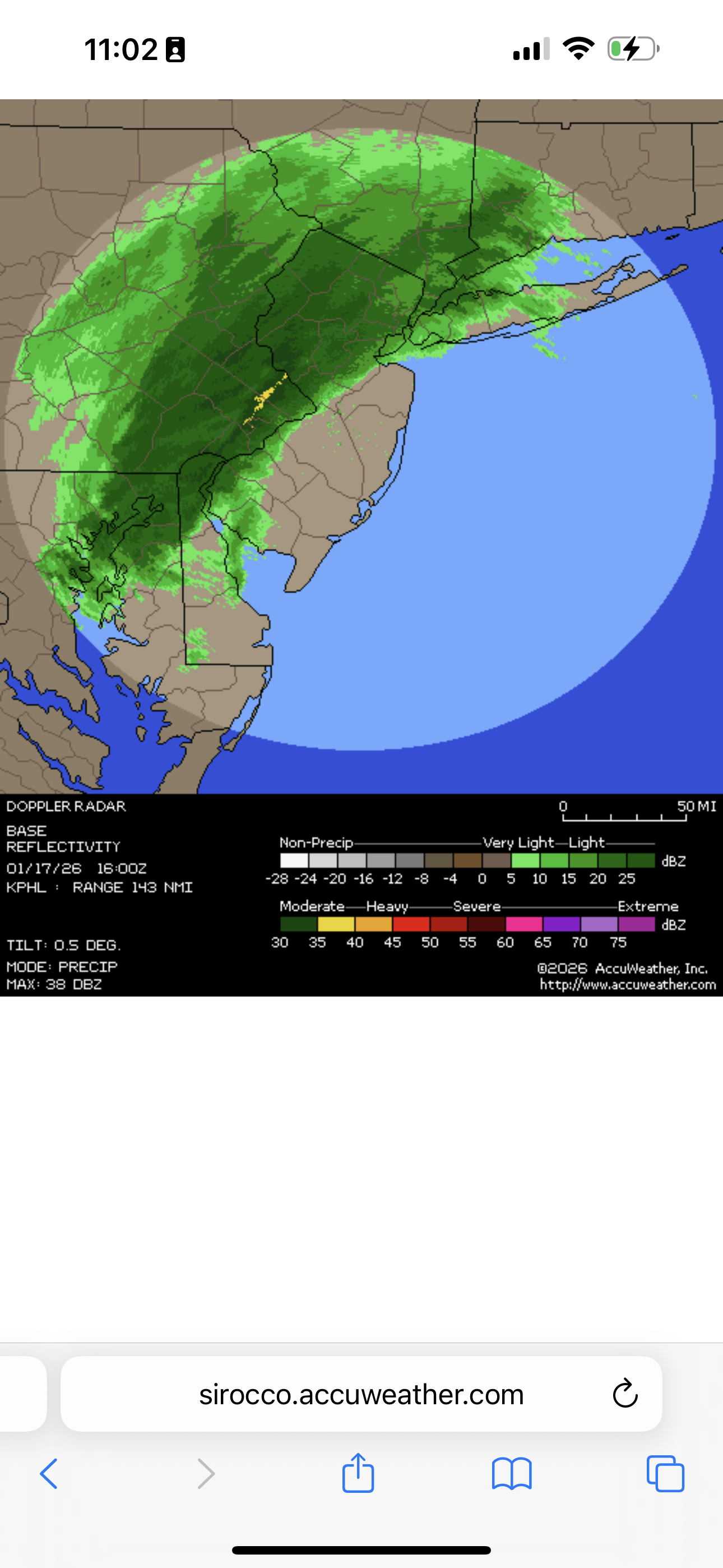
radar looks really good
-

E PA/NJ/DE Winter 2025-26 Obs/Discussion
Ralph Wiggum replied to LVblizzard's topic in Philadelphia Region
Fv3 also bullish 2-4" additional tomorrow up here. Checking other mesos now -

Storm potential January 17th-18th
Stormlover74 replied to WeatherGeek2025's topic in New York City Metro
Snow picking back up. Temp back down to 32. Should be an hour or two of moderate to heavy stuff -
Is anything *not* showing snow for Raleigh now?
-
So far, GFS is slightly wetter out west with the approaching "cold front' event...but doesn't look like anything to get hype about so far. Just a light ribbon of precip along the front
-

First Legit Storm Potential of the Season Upon Us
WinterWolf replied to 40/70 Benchmark's topic in New England
AIGFS was a little west…at this point might be a better idea to go with the machines…since they have led the way imo. Although A blend as usual is always a good idea. -

First Legit Storm Potential of the Season Upon Us
40/70 Benchmark replied to 40/70 Benchmark's topic in New England
Was basically a wash for me. -
Storm potential January 17th-18th
WeatherGeek2025 replied to WeatherGeek2025's topic in New York City Metro
moderate snow in White Plains now 33 degrees -
0.3”! See kids, complaining works!
-

Central PA Winter 25/26 Discussion and Obs
Blizzard of 93 replied to MAG5035's topic in Upstate New York/Pennsylvania
Congrats & safe travels! -
First Legit Storm Potential of the Season Upon Us
ORH_wxman replied to 40/70 Benchmark's topic in New England
OP GFs sfc kind of escaped east that run so it wasn’t quite as juiced with the main stuff. Still has moderate stuff pretty far west though. It actually might have trended slightly better over interior while being a bit worse for coast. -

First Legit Storm Potential of the Season Upon Us
moneypitmike replied to 40/70 Benchmark's topic in New England
If the south voadt can avoud rain, we might do okay. -
First Legit Storm Potential of the Season Upon Us
40/70 Benchmark replied to 40/70 Benchmark's topic in New England
Got my 5th 1/4" snowfall of the season today. -

First Legit Storm Potential of the Season Upon Us
CoastalWx replied to 40/70 Benchmark's topic in New England
I meant on gfs factoring in temps -
It’s certainly felt like winter all season. Now let’s get some moisture up in here!!!!
-

Pittsburgh/Western PA WINTER ‘25/‘26
RitualOfTheTrout replied to Burghblizz's topic in Upstate New York/Pennsylvania
NWS still seems bullish on the chance of heavier convective snow showers. Hopefully they are right. SNOW SQUALLS/SNOW SHOWERS ARE EXPECTED THIS MORNING INTO THIS AFTERNOON... Scattered snow showers are beginning to move through eastern Ohio late this morning. Some snow squalls are possible heading into this afternoon along and north of I-70. The most intense snow squalls are expected to be between 1pm and 6pm. Some challenging travel conditions will be possible with a sudden drop in visibility and a quick coating of snow within snow showers. If traveling remain alert for changing road conditions. $$ -

E PA/NJ/DE Winter 2025-26 Obs/Discussion
LehighValleyDad replied to LVblizzard's topic in Philadelphia Region
How did the 12 NAM look anyone for tomorrow? ... 6Z sure looked interesting. Given the apparent jackpotting here today, if anything falls here tomorrow that would be quite a bonus. -
Looks like more snow possible in the panhandle of FL. Two straight years?
-
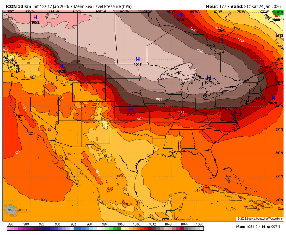
ICON looked poised to deliver some cold smoke. That is one heck of an arctic HP. Just need something with a little pep to attack.