All Activity
- Past hour
-
Yea. This is obvious. How many inches?
-
electric bill 143 gas bill 95
-
well we have been using our heating. my bill from a/c is always negligible I only use a/c in two rooms.
-
Yeah but then like now it's good to miss out on the heavy rain lol.
-
Mildly disagree about Saturday Tony-- the heavy overnight rain will be over by 7 am Saturday morning and then we'll break out into sunshine by noon or 1 pm and then showers and thunderstorms will move back into the region around 5 pm. City and points east will have less than an inch of rain.
-
Solar radiation data for mesonet showing some good spikes on the eastern shore.
-
meltdown city if this were winter and the storm moved that far west lol
-
Records:Highs:EWR: 98 (1987)NYC: 97 (1987)LGA: 96 (1987)JFK: 92 (1987) wild-- I don't remember this clean sweep at all!
-
Sun finally broke thru the fog here! It feels soupy/humid as all get out, blah. Supposed to storm later. I am 0.17" from setting a new monthly rainfall record.
-
and sunshine in the middle of the day tomorrow before the convection gets here.
-

2025 Lawns & Gardens Thread. Making Lawns Great Again
tamarack replied to Damage In Tolland's topic in New England
If you find that the natural methods and then choose chemical herbicide, I recommend a glyphosate product, preferably one with no other active ingredient. The SNJ home of our 7 grandkids had beaucoup poison ivy when they moved there in 2015. That summer I attacked the stuff with "Eliminator", the Wal-Mart version of Round-Up. (Recently, and unfortunately, they've added a bit of Diquat, far more toxic, to get quick brown-up.) -
Yes this is what I always thought. The rain will be scattered for our area which fits climo for this time of year-- no surprises there.
-
Don't care about lows, I would prefer not to have any highs lower than 70.
-
Suns out. Would like some thunder
-
Unfortunately. At least Sunday looks good. Hoping a week from today is dry, my girls have prom and want nice weather.
-
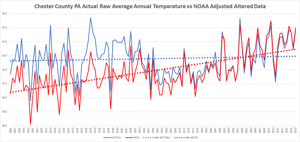
Of course there is.... note that red line that is the altered data! Blue flat - alternative fact data Red!!
-
Yeah, the Euro's dramatically yawing between synoptic concepts wrt that pinch low formulation... Doesn't lend to confidence it knows what to do, when the 12z run just yesterday morning had zero impact from that feature along with +2 SD heat intrusion to our region, and then the immediate new 00z had that thing completely shutting it all down and a 0 SD heat intrusion... The GGEM has that pinch low too, but it conserves just enough progressive w-e aspect to formulate it far enough away ( and moving E) to not be a factor here mid week. Believe it or not...it may be a compromise and better solution ... at least through 144 hours. The GFS is even more so progressed away with it. However, I hate the run overall. Longer read: It seems to be fighting the non-linearity of the teleconnection signal - which is ridging over eastern N/A's mid latitudes. It's got modest height anomalies, but it won't expand them into the correlation extent - meaning it's low balling it. It's drilling the westerlies through the top of the ridge latitudes, limiting the ridge expanse. Meanwhile, I'm noticing the CAG low genesis ( TC ) down there, which is a feature not uncommon to the -PNA summer, whence ridging formulates over the eastern conus this creates favorable genesis period in the Caribbean gyre region at low latitudes underneath. Near the Yucatan Pen and Bay/Camp. etc. So It's like the GFS is seeing the the whole scope, but is shirking the ridge part of it. The GFS has about .1% w-e stretched bias at all times ( sarcasm but true-ish) at all times - definitely used to, but has improved with that progressivity bias some over the years of upgrading the model. This strikes me as possibly interfering just enough albeit subtle, nonetheless.
-
SPC expanded the slight risk area northward. Now covers almost all VA and MD east of the mountains.
-
i think most places east of the rain axis will manage an inch from bands of convection
-
WTH
-
Beween 12:30 - 1:30 am it seems. I've never seen a "look back" radar but that'd be cool!
-
For tomorrow looking pretty strongly like the offshore ridging is winning out and driving the heavy rain axis to our west over NJ/Hudson Valley. Maybe a few inches of rain there over the reservoirs, more showery from the city on east.
-

2025 Atlantic Hurricane Season
AStorms13 replied to BarryStantonGBP's topic in Tropical Headquarters
Let the season of overreactions BEGIN!
-
Records: Highs: EWR: 98 (1987) NYC: 97 (1987) LGA: 96 (1987) JFK: 92 (1987) Lows: EWR: 39 (1949) latest 30s low NYC: 42 (1884) LGA: 48 (2021) JFK: 45 (1949) Historical: 1879 - A major outbreak of severe weather occurred in Kansas and western Missouri. In Kansas, tornadoes killed eighteen persons at Delphos, and thirty persons at Irving. Two tornadoes struck the town of Irving within a few minutes time virtually wiping the small Kansas community off the map. The second tornado was perhaps two miles wide, and exhibited multiple vortices. (David Ludlum) (The Weather Channel) 1927: The Kentucky River peaks during a massive flood that killed 89 people and left thousands homeless. Torrential rains caused this unprecedented flood. 1948 - A railroad bed acting as a dam gave way during a flood along the Columbia River destroying the town of Vanport, OR. The nearly 19,000 residents escaped with little more than the clothes on their backs. (David Ludlum) 1948 - Twenty carloads of glass were needed in Denver, CO, to replace that destroyed by a severe hailstorm. (The Weather Channel) 1982: An amazing 17 inches of rain fell in a nine day period of time ending on this date at Avon, South Dakota. This led to major flood problems in the area. Krug's lake, located one mile south of Avon, is normally dry. Not only did the lake fill up, but it also drained into the south side of the town after a hastily constructed dike gave way. Many dwellings in the town ended up being completely surrounded by water. (Ref. Wilson Wx. History) 1983: Unusually high temperatures throughout the western United States caused a rapid runoff from snow pack in the Rocky Mountains. This caused flooding which washed out bridges and caused mudslides in parts of Nevada. (Ref. Wilson Wx. History) 1987 - Unseasonably warm weather prevailed across the eastern U.S. Eighteen cities, from Virginia to Ohio and Michigan, reported record high temperatures for the date. Afternoon highs of 97 degrees at Baltimore, MD, and Washington, DC, and 98 degrees at Newark, NJ, were records for the date. (The National Weather Summary) 1988 - Memorial Day heralded heavy snow in some of the mountains and higher passes of Wyoming, closing roads in Yellowstone Park. McDonald Pass, MT, was blanketed with eight inches of snow, while the temperature at Miles City, MT, soared to 94 degrees. A "supercell" thunderstorm in west Texas produced baseball size hail in Bailey and Lamb counties, and up to five inches of rain in less than an hour. (The National Weather Summary) (Storm Data) 1989 - Thunderstorms produced severe weather from the Upper Mississippi Valley to the Upper Ohio Valley during the day. A powerful (F-4) tornado injured three persons and caused a million dollars damage at New Providence, IA. Baseball size hail was reported at Blue Earth, MN. (The National Weather Summary) (Storm Data) 1990 - Thunderstorms developing along a warm front spawned fourteen tornadoes in northeastern Texas during the late afternoon and evening hours. The thunderstorms also produced baseball size hail near Marshall, wind gusts to 77 mph at Commerce, and up to five inches of rain. Thunderstorms over southwestern Kansas produced up to six inches of rain. (The National Weather Summary) (Storm Data) 1988: Memorial Day heralded heavy snow in some of the mountains and higher passes of Wyoming, closing roads in Yellowstone Park. McDonald Pass, Montana was blanketed with eight inches of snow, while the temperature at Miles City, Montana soared to 94 degrees.
-
Enhanced risk now. Includes the Triangle and parts of the Triad.


