All Activity
- Past hour
-

November 2025 general discussions and probable topic derailings ...
dendrite replied to Typhoon Tip's topic in New England
Min 21.7° 19° down in town along the river. -

December 2025 Short/Medium Range Forecast Thread
jaxjagman replied to John1122's topic in Tennessee Valley
Euro backed off from any SSW upcoming with not much of any wind reversal to what its been showing.JMA has the temps around -65C which is around what the Euro shows last update,Euro only shows the temps will get close to -60C in 10 days,so right now no SSW just some weakening,least not right now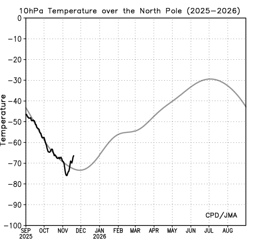
-
November 2025 general discussions and probable topic derailings ...
dendrite replied to Typhoon Tip's topic in New England
Probably still related to Cloudflare -

2025-2026 ENSO
michsnowfreak replied to 40/70 Benchmark's topic in Weather Forecasting and Discussion
Not sure if it matters but those were 500mb temps, not surface temps. That said, November 1950 saw an incredible shift in temps. At Detroit, November 1st saw the all-time November high temp of 81°, to this day the only time 80 has been seen in November...then 7° on November 24th. -

Central PA Fall Discussions and Obs
Superstorm replied to ChescoWx's topic in Upstate New York/Pennsylvania
Ditto in Lancaster . -
 I looked quickly and saw it pushing the PV down towards Hudson Bay, so there will be cold lurking. GEFS do that too.
 -

November 2025 general discussions and probable topic derailings ...
UnitedWx replied to Typhoon Tip's topic in New England
I just saw it... however just like every other model, it's a totally different solution than the one prior, and likely the next. It does show that something could happen in the time frame, but who knows what at this point -

November 2025 general discussions and probable topic derailings ...
WinterWolf replied to Typhoon Tip's topic in New England
What are you wasting in mid November? This is the stepping down process..it’s been right on target this fall. -
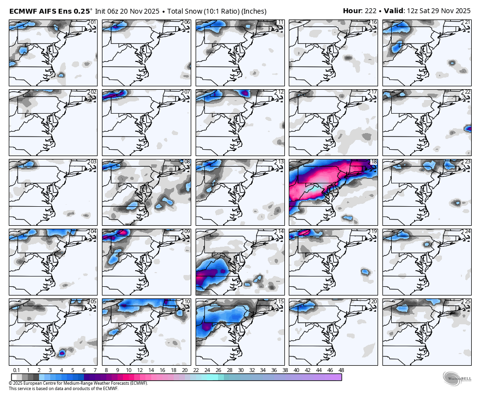
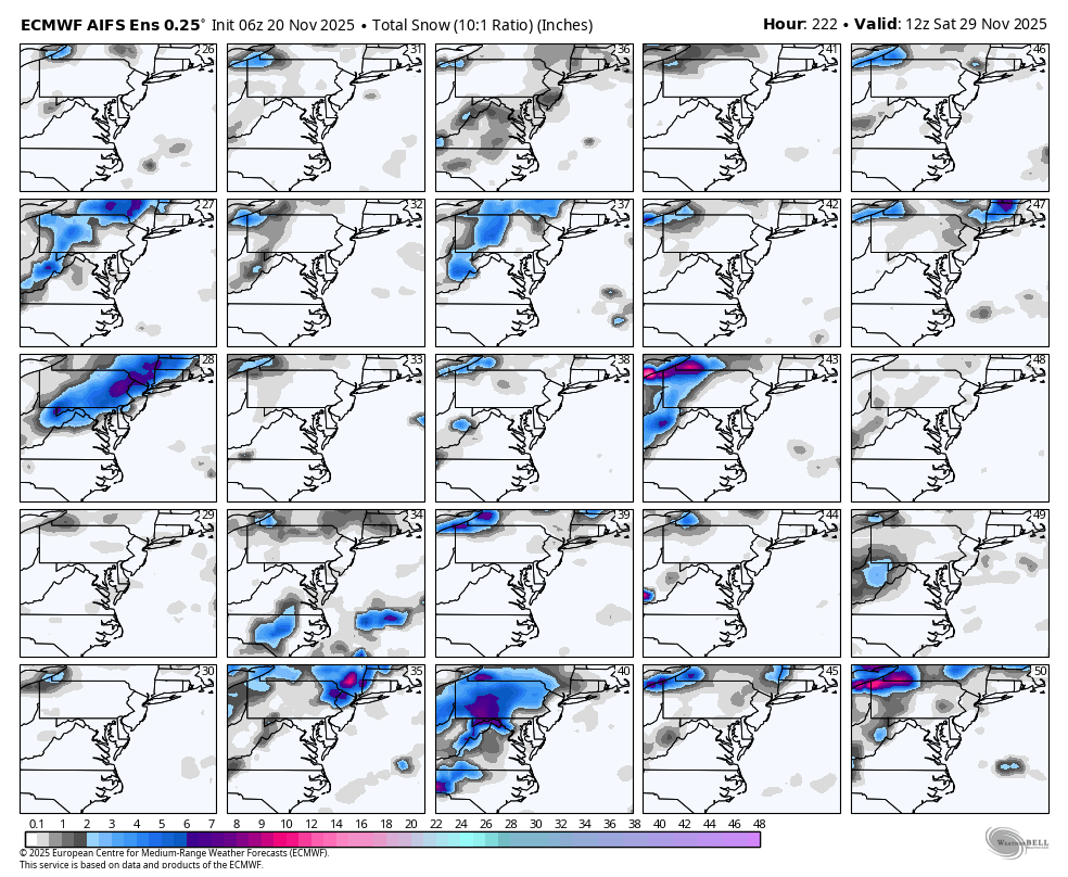
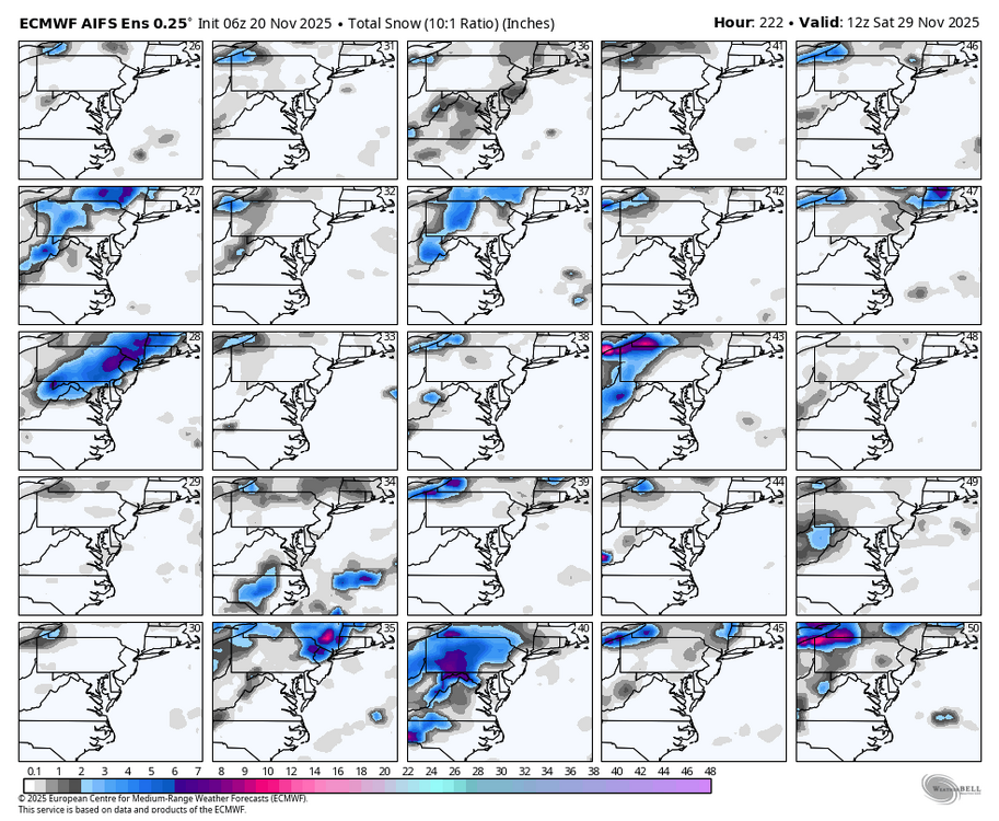
WB 6Z AI ensemble....lock in our 1-50 chance for a post Thanksgiving blizzard.

-
November 2025 general discussions and probable topic derailings ...
WinterWolf replied to Typhoon Tip's topic in New England
Let’s elaborate some. -
28 currently. Feels like November.
-
Gotta watch this. If you pop a poleward Scandinavian ridge here that suggests further damage to the PV sometime in December.
-

2025-2026 ENSO
40/70 Benchmark replied to 40/70 Benchmark's topic in Weather Forecasting and Discussion
This trend is more in line what with my thought process. I anticipate a more rapid recovery of the PV than some guidance has implied due largely to how I feel the stratosphere will evolve mid season (mid January reflection event). -
My cherry tree canceled winter....

-
Thanks for sharing .
-

November 2025 general discussions and probable topic derailings ...
ariof replied to Typhoon Tip's topic in New England
The Euro op is close to as bad as possible for holiday traffic. Basically wipes Saturday off the map for the entire northeast from DC north, hitting all the airports and roads. Maybe a bunch of people who would normally have traveled on Saturday don't, so the plows can still get out (because once a traffic jam occurs and people stall out, everyone is stuck) but that means adding a lot of volume on Sunday when the roadways are already over capacity. Backups on the Pike and in Connecticut would be epic. (This guy is glad to have train tickets back from Philly on Friday …) -

Pittsburgh PA Fall 2025 Thread
Gordo74 replied to TheClimateChanger's topic in Upstate New York/Pennsylvania
https://paweatheraction.com/polar-vortex-favorable-conditions-setting-up-a-cold-snowy-december/ Seems like there's the beginning of smoke. Hopefully something shapes up. -
2025-2026 ENSO
40/70 Benchmark replied to 40/70 Benchmark's topic in Weather Forecasting and Discussion
This is my thinking, as well...but I am nervous. -

E PA/NJ/DE Autumn 2025 Obs/Discussion
Mikeymac5306 replied to PhiEaglesfan712's topic in Philadelphia Region
28 and hard frost on my truck this morning. In other news, overnight Euro has something trying to spin up next weekend. -
November 2025 general discussions and probable topic derailings ...
ariof replied to Typhoon Tip's topic in New England
KBOS finally broke the dam … 32˚ for several hours, after the 5th 34˚ reading yesterday morning (and a 33˚) this month. 15 days after normal. Month now running more than 1˚ below normal. Congrats to the airport (I think the rest of the city has been well below freezing since I nearly fell on my behind the other day.) -
27° for a low. Bounced around between 28-31 most of the night
-
December 2025 Short/Medium Range Forecast Thread
jaxjagman replied to John1122's topic in Tennessee Valley
BOM has the reconstructed MJO back to 1975 here,i know you look at analogs all the time maybe that can help out some https://www.bom.gov.au/climate/mjo/#tabs=Monitoring -
-

November 2025 general discussions and probable topic derailings ...
CoastalWx replied to Typhoon Tip's topic in New England
Clouds again this morning, but still 28. -
November 2025 general discussions and probable topic derailings ...
CoastalWx replied to Typhoon Tip's topic in New England
It was weird for me yesterday.