All Activity
- Past hour
-
Ha I didn’t even realize you posted before they did pull the trigger
-
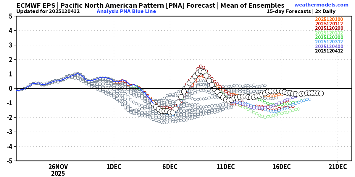
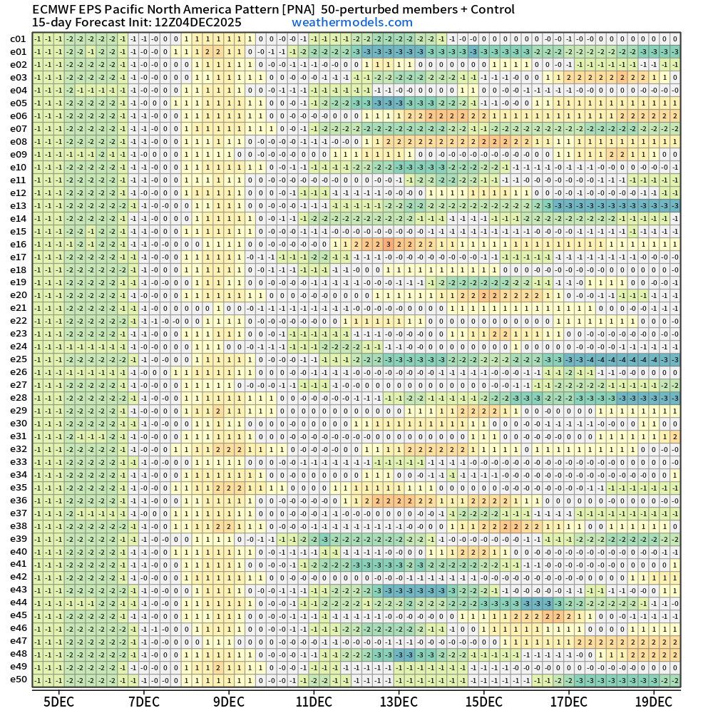
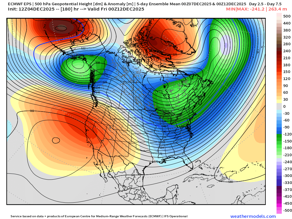
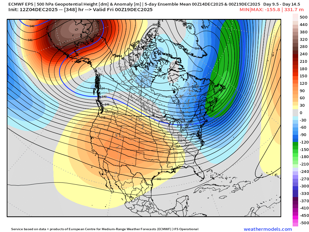
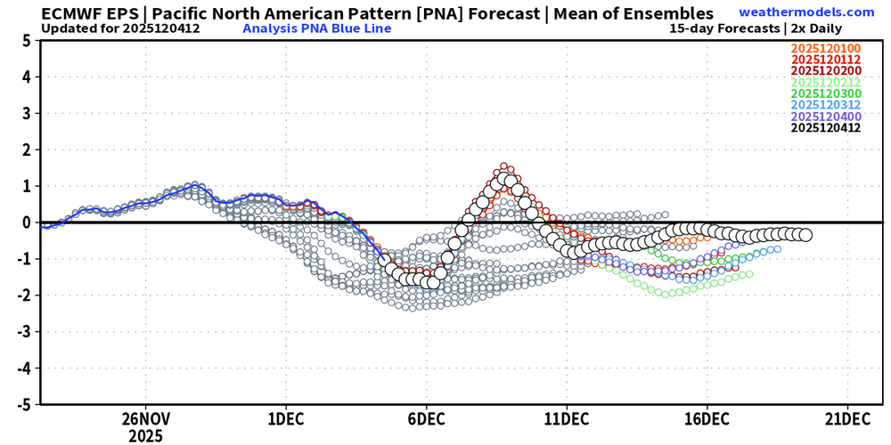
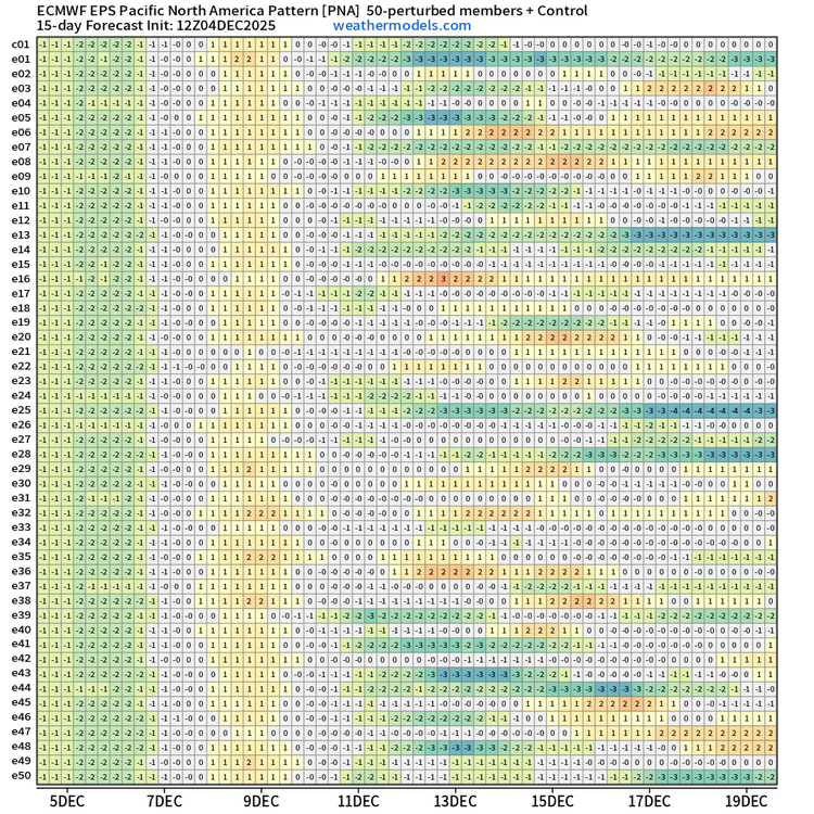
I hear your point about the dangers of oversimplying ENSO-PNA relationships, Don, and wholeheartedly agree. However, from my perspective there is increasing evidence the PNA will average neutral overall (with some periods of slightly positive PNA, especially Dec 7-9 and Dec 14-20) the second and third weeks of Dec. True, the EPS pattern days 3-7 and 11-15 is not fully in line with a canonical +PNA (the positive anomalies are shifted south and west vs. the typical position over western Canada and the NW US, the negative anomalies are concentrated over SE Canada and the NE US vs. the mid-Atlantic and SE US, and the upstream negative anomalies are in the e. Gulf of Alaska vs. the typical position further SW in the north-central Pacific). However, both the EPS and GEPS have been trending toward a more neutral PNA in most of the next two weeks (e.g. Dec 7-10 and Dec 14 and beyond). The charts you showed were from the GEFS, which has the most -PNA (and SE US ridge) biased of all the models recently. Also, looking at the EPS individual members it is evident that a few members with a highly negative PNA are skewing the mean downward Dec 14 onward. A slightly majority of members (about 55-60%) actually show a +PNA during that timeframe! The GEPS is not as aggressive, but still has about 40-50% of members showing a +PNA in the same timeframe. Regarding the last third of Dec, there is too much uncertainty to comment much on that period. While I favor the SE US ridge returning to a degree, I am skeptical of the strength of the NW/N-central US trough and SE US/W Atlantic ridge shown in the past two EPS long-range runs.
-
need some posts here with people worrying about temps the day before the "storm"
-
Got to admit it’s getting better . Getting better all the time-won’t get no worse.
-
Great path except it dies as it gets here.
-
Noise at this point
-
HRRR is a tick better than 12z

-
WWA hoisted to include both metros. Lets reel this one in!
-
Looks like latest hrrr has light snow in dc metro from 3am to 9am or so. .
-
Ha. Meant to say have NOT pulled the trigger... Posted this just before they did, apparently.
-
Hiking Lafayette in my yoga pants and tevas tonight. Wish me luck.
-

Mid to long range discussion- 2025
WinstonSalemArlington replied to wncsnow's topic in Southeastern States
-

2025-2026 Fall/Winter Mountain Thread
Maggie Valley Steve replied to Buckethead's topic in Southeastern States
Stuck at 41 after a low of 26. Wet bulb is 28 with a DP of 19. Radars from Morristown and Nashville are juicy! -
Parts of the area also got snow on 12/5/2003. That was back when N&W suburbs meant something. I had like 8" in Germantown and rode the MARC to DC for work and it was wet ground there
-
A good trend that Wakefield extended the WWA SE to include the Peninsula. Hopefully they extend it SE more tonight.
-
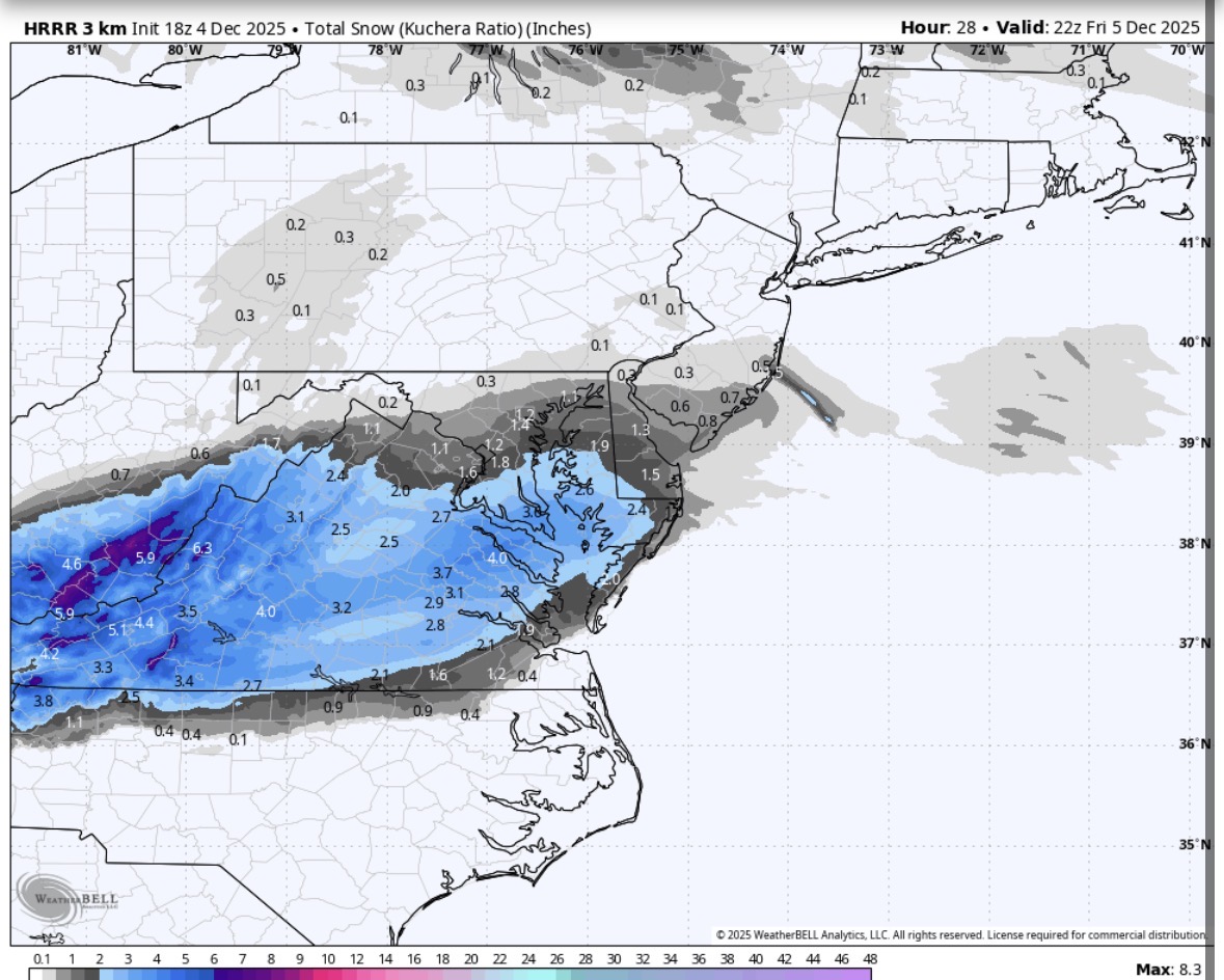
My 4 model blend increased from 1.6" at 8 am to 2.4" at 1 pm.................... I will predict 2 - 4 inches for Augusta in my newsletter a little later, with snow developing 1 - 3 am. For D.C., my thoughts are .5" - 1.0" with flurries by 5 - 6 am.
-
Treating roads has begun here in the tropics
-
Moisture trying to make it down. 40/23. I've seen 4 flakes so far. LOL!
-
It’s because it’s happening in the morning during the commute.
-
18z HRRR is running, looks similar to 12z at hour 14.
-
Wasting money or brining... They have only been brining the roads for the last 15 years or so. Also, anyone that think the brine is beet juice or anything else... It is 77% water and 23% salt... so just another way to ruin our vehicles.
-
Congratulations Terp.!!
-

Winter 2025-26 Medium/Long Range Discussion
Chicago916 replied to michsnowfreak's topic in Lakes/Ohio Valley
Winter "MCS" szn -
They have been doing this for ages, good luck getting them to stop wasting the taxpayers money.
-
Looks like southern DE or the southern peninsula near Exmore will be a good chasing spot.