All Activity
- Past hour
-
Lol, let's get warning criteria. I think people around here are unaware they'll wake up to snow to deal with.
-
What do all say about the 41" report in Fall River? https://x.com/snewengweather/status/2026098368804487556 I see it plotted on the JDJ map, but it does not seem to jibe w/ surrounding totals. Also, NWS BOX did not included it in their PNS. Looking at the photos, it is a tape measure and those can bend at the bottom against a solid surface, or since several inches of snow was on the ground prior, is that accounted for? This reminds me of the Bridgewater MA 41" report in the Bliz of '05 (I think that was the storm). Every time I brought that up to CoastalWx, he would vehemently deny that actually fell there! LOL.
-
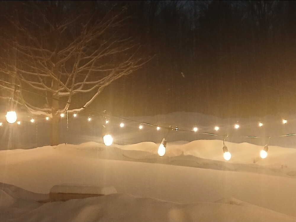
Man I'm glad this rain train is staying to my south. We've gotten over an inch but to be honest our soil has been quite moist coming out of the thaw last month. I won't mind inch here there through May. besides keeping the mud to a minimum it is extra good for the coming mushroom season. Heavy heavy rains will shut it down. Here's a pic if anyone wants to start training
-

Pittsburgh/Western PA WINTER ‘25/‘26
Rd9108 replied to Burghblizz's topic in Upstate New York/Pennsylvania
It can still snow in May here. I get that ot doesnt stick around though. -
24.8° -SN 5.9”/0.60”
-
-
I’m sure but remarkable when you think about how the winter started. The ebbs and flows I suppose.
-
30F with freezing rain. Ice coated trees. Snowpack. Frozen roads and sidewalks.
-
05z PWM - With a few more hours to go, this will be a bigger event here than the blizzard (4.5") and deepest pack of the season. 2.5" new (0.27 SWE) 4.3" total ( 0.47 SWE) Depth - 15"
-

Winter 2025-26 Medium/Long Range Discussion
DocATL replied to michsnowfreak's topic in Lakes/Ohio Valley
True…not a universal thing. Michigan may still do well. -
Winter 2025-26 Medium/Long Range Discussion
DocATL replied to michsnowfreak's topic in Lakes/Ohio Valley
Past is prologue. -
Bruh what/when was this from? Hahaha
-
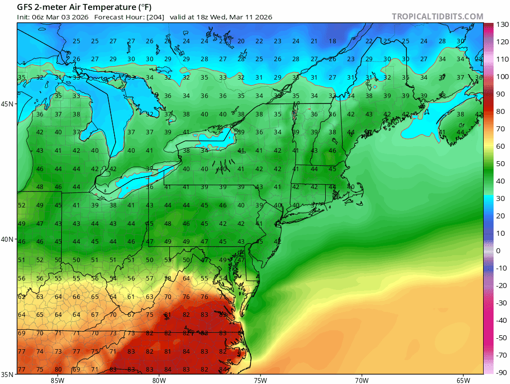
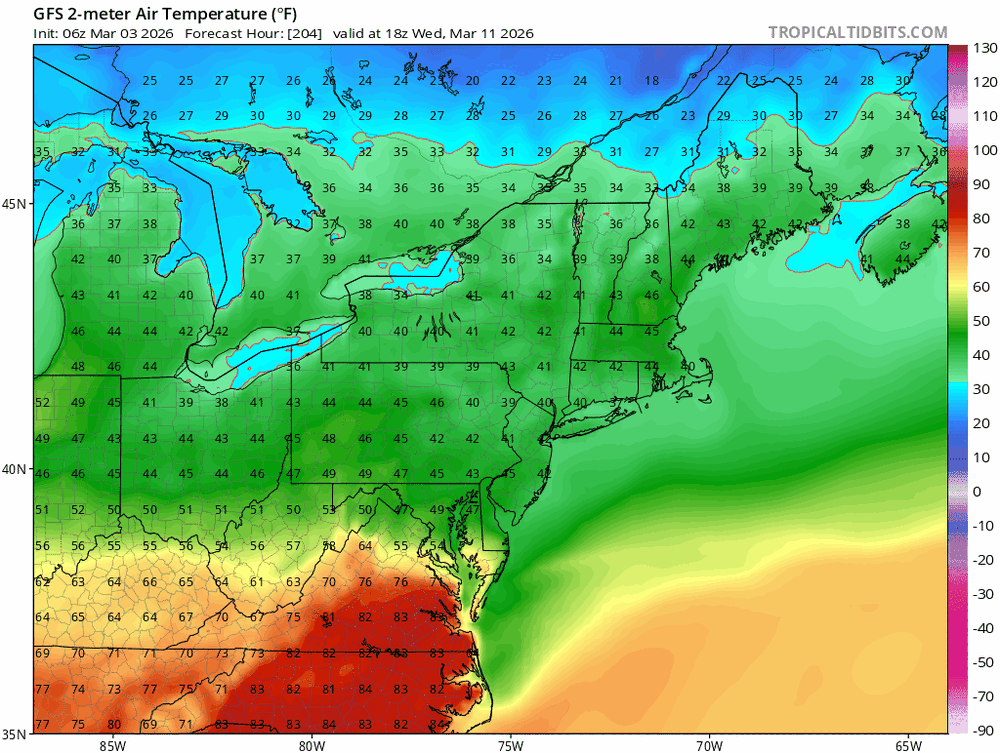
Really incredible AI map of the country there...
- Today
-
except for maybe ACK. No reports from there but im estimating 24-36" there I never realized how bad of an area the 91 CTRV in central Hampden and Hampshire counties were until i started putting together these maps and seasonal snowfall stuff. They are just in the worst possible spot, shadowed by the ORH and Berkshire hills, too far north and miss a lot of coastals and E MA specials, too low elevation to do well in those type of events. It's almost better to be in central CT and around Windsor Locks area than up there.
-
We have ~4'' in lebanon. I'm impressed by the remarkably good snow quality.
-
Just want this snow to melt so I can do some shit in the yard. Still 10” of snow in the shade. Just a solid glacier that refuses to go away.
-
In case this is the last event, here's my data. I have every storm for 23 winters. Contact Randy if anyone wants it. Mt Pleasant DC 04-05 - 17" 05-06 - 17.5" 06-07 - 13.5" 07-08 - 7.5" 08-09 - 10" 09-10 - 67.5" 10-11 - 12.5" 11-12 - 2" Old Town Alex 12-13 - 5" Downtown DC 13-14 - 36.5" 14-15 - 20" 15-16 - 26" 16-17 - 5" 17-18 - 10" 18-19 - 19" 19-20- 0.5" 20-21 - 6.5" Adams Morgan 21-22 - 14.5" 22-23 - 0.5" 23-24 - 8" 24-25 - 15.5" 25-26 - 14" to date 26-27 (Philly)
-
Just checked out your updated seasonal map through March 2 and I’m honored to be the lowest total in all of SNE!
-

Winter 2025-26 Medium/Long Range Discussion
cyclone77 replied to michsnowfreak's topic in Lakes/Ohio Valley
Probably for everyone other than Michigan if it's like the rest of the winter. -
It's also a bad idea to say that winter is over on March 3rd. Just sayin'.
-

Winter 2025-26 Medium/Long Range Discussion
michsnowfreak replied to michsnowfreak's topic in Lakes/Ohio Valley
Who says the NW flow will be all dry? -
They just might get it.
-
Thanks, will email WFO GYX for the complete top 20 list of PWM storm surges.
-
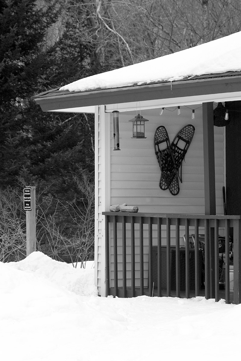
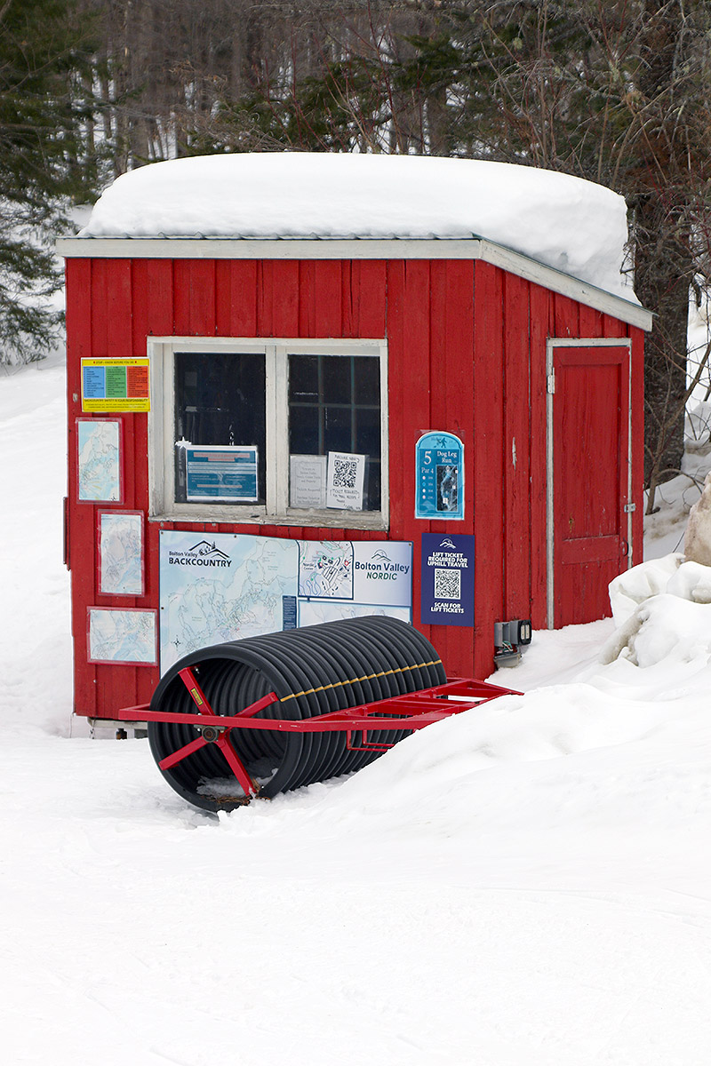
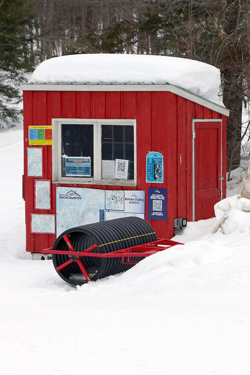
As folks noted in the thread, with the return of some arctic air, the past couple of days have been a bit too cold to easily entice one out onto the slopes after Saturday gave us that taste of spring warmth. I was last out on the mountain on Saturday, and I finished up my ski tour around noon. On that descent, the freezing line had risen to 2,400’ in the Bolton Valley area, and from that point down the surface of the powder had become sticky and essentially unskiable. I was curious to know just how far the freezing levels had gone, and with temperatures rising into the upper 40s F in the lower valleys on Saturday once the sun came out, I figured the freezing level must have risen even further. I had some time today, so I decided to head out for a tour on the Bolton Valley Nordic & Backcountry Network to assess the quality of the unconsolidated snow. With the way the powder had become wetted from at least 2,400’ and below, I wasn’t too optimistic about what I was going to find with respect to the quality of the powder skiing, but I figured worst case I’d get a workout in anyway, and I could always make a quick descent via the Bryant Trail if the powder was a crusty mess. Today I headed up in the midafternoon timeframe, and temperatures were around 35 F in the valley in the 200’-500’ elevation range, I hit the freezing line around 1,000’ on the Bolton Valley Access Road, and up in the Bolton Valley Village at 2,000’ the temperature was around 30 F. Right from the start of my tour, I could immediately tell that we were still in business with respect to the quality of the powder. There was a light melt crust on the surface, but it was nearly insignificant and the overall snowpack surface was really still holding onto that same consolidated powder that I’d encountered out there on Saturday. So, while those cold temperatures of the past couple of day may not have been appealing for getting outside, it turns out that they were beneficial with respect to the quality of the snow. The dry arctic air let any wetting of the snow dry out, and the powder really recovered quite nicely. For today’s tour I headed up past Bryant Cabin and onto Heavenly Highway, topping out around 2,900’. I focused my descent on low and moderate angle terrain based on what I’d learned from my tour on Saturday, and those pitches definitely delivered. You still wanted to avoid any terrain that had been hit by sun or wind, because those effects has certainly degraded the powder surface, but as long as you did that and avoided southerly aspects, there were plenty of surfy powder turns. The melt crust did get a bit more noticeable below the 2,400’-2,500’ level, so below those elevations you had to be a bit more diligent about avoiding areas exposed to any sun. Ironically, as I thought I might be descending on packed terrain today if the powder had been shot, packed terrain was to be avoided if possible. Terrain that had seen traffic during the warmth was too packed to recover its winter character below a certain elevation. It was slick and hard, and it was simply best to just ski in snow off to the side. On my ascent, I had noticed that people had made separate skin tracks off to the side of the packed areas, and I didn’t know why at first, but on the descent it became more obvious – it was just a much better ski surface. I had actually even used those sidetracks on my ascent a bit as well because the main traffic areas with packed snow were somewhat slick and my skins even lost grip at times. Our next snowstorm is currently ongoing, so we’ll have to see how much snow we pick up and how things shape up with respect to this next layer. This storm may deliver snow on the denser side, but I’m actually not too worried about the powder gradient getting noticeably upside down because there’s already decent density in the surface snow at this point.

-

12th Annual Mid-Atlantic Snowfall Contest
NorthArlington101 replied to RodneyS's topic in Mid Atlantic
Pretty content with third if this is it. But hope the AIFS is right and I get blown out.