All Activity
- Past hour
-
DEN picked up 3.4" on Friday, putting them at 27.1" on the season. This means 2025-26 is officially no longer the least snowy winter for Denver in the airport era.
-

2026-2027 El Nino
Stormchaserchuck1 replied to Stormchaserchuck1's topic in Weather Forecasting and Discussion
Cooler May? NAO was 2nd highest monthly all time in March 2026. 12 weeks x 75 years = 900 analogs. The following May in totality of analogs is surprisingly cold: CPC has it at least starting out this way -

2026-2027 El Nino
LakePaste25 replied to Stormchaserchuck1's topic in Weather Forecasting and Discussion
Yup. 15-16 is a good example of a super that starts out east-based before going basin wide approaching winter. -
2026-2027 El Nino
Stormchaserchuck1 replied to Stormchaserchuck1's topic in Weather Forecasting and Discussion
^Right now it's developing from the west and the east, signaling basin-wide. Nino 1+2 doesn't correlate as highly as a lead in April, surprisingly. Here is Nino 1+2 vs Nino 4 for +8months Dec SSTA -

E PA/NJ/DE Spring 2026 Obs/Discussion
Mikeymac5306 replied to PhiEaglesfan712's topic in Philadelphia Region
I too had a quick round of graupel In West Chester albeit 45 seconds worth. -
Heavy wet snow while driving under this cell on route 3/44 in Plymouth. Unexpected
-
Freeze warnings
-
42 with a few flakes flying
-
.thumb.jpg.6a4895b2a43f87359e4e7d04a6fa0d14.jpg)
Central PA Spring 2026 Discussion/Obs Thread
Yardstickgozinya replied to Voyager's topic in Upstate New York/Pennsylvania
Absolutely, I saw that in the discussion today, pray for clouds and wind. -

2026-2027 El Nino
snowman19 replied to Stormchaserchuck1's topic in Weather Forecasting and Discussion
^”See the magenta in the middle of the map? That’s alert level 4 of 5 for bleaching in the #Galapagos. Common in El Niño (or in this case developing) where cool water upwelling slows/ stops and surface waters significantly warm. The sea surface temp anomaly is +3-4°C (~6°F). That’s why life suffers there every El Niño, esp. east based episodes Thanks @NOAACoral” -
I got my April Trace in at 1:52pm this afternoon with a brief light burst of some gruapel/mangled snowflakes.
-
Yeah we got rain last two fronts, which is some encouragement. QPF came in under, not a surprise in drought - but at least it's raining. See if we can accomplish more this weekend into next week. Even poorly timed waves (see my severe rant) can bring rain. Seems like a decent bet. Then we'll see how long we can milk the southern jet stream next week. Could it be a drought breaker? Could it just add humidity before the SER gets on steroids? I don't believe the CFS or Euro weeklies. Check back in June!
-
I think there will be additional chances especially for your area around 4/28-5/3
- Today
-
Ok now we just need a good 2 day soaking rain and then some sun plz thx
-
2026 Atlantic Hurricane Season
Stormchaserchuck1 replied to Stormchaserchuck1's topic in Tropical Headquarters
Unfavorable SSTA for big season as it stands currently -

Spring 2026 Pattern Discussion Thread
Carvers Gap replied to Carvers Gap's topic in Tennessee Valley
We have managed a couple of decent rain showers. It won't dent the drought, but it will provide some temporary relief. As for relief, there might be some on the way as we begin May. Temps look to fall BN right as we end April and begin May. It won't be anything overly shocking I don't think - some frost likely I think. It will feel sharper than it really is due to the much AN temps we have seen(summer like) during the past couple of weeks. Hopefully, that heat has abated until its proper time. I don't see mid 80s on my phone any longer, and that is a relief. We don't want summer heat building during April. Even with La Nina fading, any residual effects from that dying Enso phase could still produce very hot and dry weather. Hopefully, Enso neutral and Nino conditions take hold sooner than later. That should bring more precip and moderation of temps.- 185 replies
-
- 1
-

-
- severe
- mountain snow
- (and 1 more)
-
2026-2027 El Nino
Stormchaserchuck1 replied to Stormchaserchuck1's topic in Weather Forecasting and Discussion
Nino 4 is the loading pattern for a Nino 3.4 El Nino. CDAS is currently much higher than CPC. This event is developing basin-wide like 2015-2016 or further west than most Strong Nino's. If it keeps developing further west at its core, I don't think it will go Super, but perhaps Strong, or per RONI high-end Moderate. -
We're not doing watches and warnings. Season's canceled. That's not commentary on the system. That's angry storm chaser venting. This weekend into early next week I would bet a stack of chips on poorly timed waves. Well, that's good for the storm anxious. Note it's a week out. I'm being a pessimist more than a scientist today.
-

Central PA Spring 2026 Discussion/Obs Thread
Itstrainingtime replied to Voyager's topic in Upstate New York/Pennsylvania
Still a couple things to resolve - cloud cover and wind. We need those to work out to really drop. -
Morch and the torch definitely sped things up this year.
-
(002).thumb.png.6e3d9d46bca5fe41aab7a74871dd8af8.png) Due to multiple requests below for comparison I have added the recast National Centers for Environmental Information (NCEI) temperature data that includes the chilling adjustments to the older data. That chart is now below the actual raw data. I split our weather database almost down the middle to compare how our climate here in Chester County has changed compared to the first 66 years of climate data (1893-1959) vs. the last 67 years of data (1960-2025). With the actual data we see that 7 of our months have trended cooler - 3 have trended warmer and 2 have remained about the same. Overall, on an annual basis the actual raw data has trended cooler by 0.2 degrees during our most recent half of climate data 1960-2025. However, once NCEI applies their adjustments it paints a very different picture. We see clear warming in each and every month during our more recent climate history from 1960-2025. This aligns well with the expected warming narrative.
Due to multiple requests below for comparison I have added the recast National Centers for Environmental Information (NCEI) temperature data that includes the chilling adjustments to the older data. That chart is now below the actual raw data. I split our weather database almost down the middle to compare how our climate here in Chester County has changed compared to the first 66 years of climate data (1893-1959) vs. the last 67 years of data (1960-2025). With the actual data we see that 7 of our months have trended cooler - 3 have trended warmer and 2 have remained about the same. Overall, on an annual basis the actual raw data has trended cooler by 0.2 degrees during our most recent half of climate data 1960-2025. However, once NCEI applies their adjustments it paints a very different picture. We see clear warming in each and every month during our more recent climate history from 1960-2025. This aligns well with the expected warming narrative.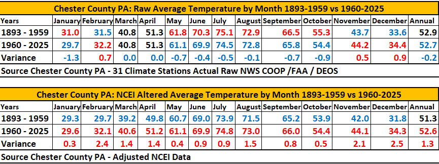
-
Poor little birdie smacked my living room window. Heard a loud thump, and when I checked, there he was sitting on the deck rail trying to regain his bearings. At least he made it. Sometimes they break their neck. Not uncommon to find a dead bird laying on the deck.
-
Seems reasonable to assume a T. We have now had three separate graupel/snow showers blow through, all moving NW-SE (and Arlington is SE of us). Together with @pazzo83's DC observation, seems likely that both Arlington and DC got a T. But maybe that's just my weenie logic.
-

E PA/NJ/DE Spring 2026 Obs/Discussion
Chadzachadam replied to PhiEaglesfan712's topic in Philadelphia Region
I'm not saying that it accumulated but we were under a squall that was frozen precip, bouncing off the cars, much too small/atmospherically stable for hail. so yes, it was sleeting heavily and I don't think that's all that historic -
We’re getting a passing shower and yet I could’ve sworn I’ve seen some frozen precip in the mix. Maybe even mangled snowflakes or graupel. And that is in spite of it being partly cloudy and 47. I’ve seen this before even in Maryland, usually in the spring when there’s a cold airmass in place and it’s probably a lot colder aloft.


